+ All Categories
Home > Documents > Loru Forest Project - Project Description (PD) Part B: PES ... · PDF fileLoru Forest Project...

Loru Forest Project - Project Description (PD) Part B: PES ... · PDF fileLoru Forest Project...

Date post: 09-Mar-2018
Category:
Upload: buithu
View: 218 times
Download: 1 times
Share this document with a friend
91
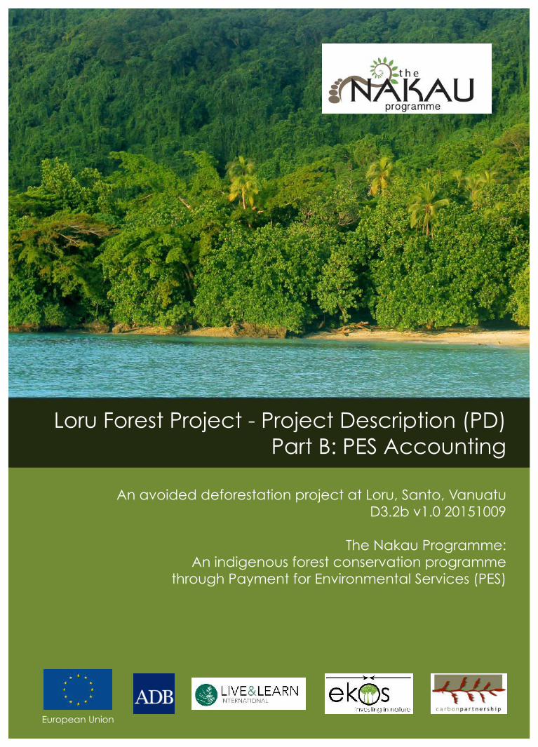
Loru Forest Project - Project Description (PD) Part B: PES Accounting An avoided deforestation project at Loru, Santo, Vanuatu D3.2b v1.0 20151009 The Nakau Programme: An indigenous forest conservation programme through Payment for Environmental Services (PES) European Union
Transcript

Loru Forest Project - Project Description (PD)Part B: PES Accounting

An avoided deforestation project at Loru, Santo, VanuatuD3.2b v1.0 20151009

The Nakau Programme:An indigenous forest conservation programme

through Payment for Environmental Services (PES)

European Union

LoruForestProjectPDPartB(AD-DtPF):D3.2bv1.0,20151009

2

A project of Live & Learn Environmental Education in collaboration with Carbon Partnership Ltd.FundedbytheEuropeanUnionandtheAsianDevelopmentBank.Reportpreparedby:SeanWeaverandIanPaytonCover Photo: Weaver - view towards the coastal fringe of the Loru Project site from the sea, eastEspirituSanto,Vanuatu.TheNakauProgrammeRossHouse,4thFloor247–251FlindersLaneMelbourne3000Victoria,AustraliaTel:+61396501291Email:[email protected]:www.nakau.org

___________________________

Suggestedcitationforthisreport:Weaver,S.A.andPayton,I.2015.LoruForestProject,ProjectDescriptionPartB:PESAccounting.AnavoideddeforestationprojectatLoru,Santo.D3.2bv1.0,20151009.TheNakauProgrammePtyLtd.

ThispublicationhasbeenproducedwiththeassistanceoftheEuropeanUnion,intheframeworkoftheproject "Pilot effective models for governance and implementation of REDD in Small IslandsDevelopmentStatestoprovideequitablebenefitsforforestdependentlocalandindigenouspeople",co-fundedbytheEuropeanUnion.Thecontentsofthispublicationarethesoleresponsibilityoftheauthorsand Live & Learn Environmental Education and can in no way be taken to reflect the views of theEuropeanUnion.

European Union

LoruForestProjectPDPartB(AD-DtPF):D3.2bv1.0,20151009

3

TableofContents1.ELIGIBILITY&GUIDANCE ..........................................................................................61.1 Eligibility ................................................................................................................. 71.1.1GeneralEligibility ................................................................................................. 71.1.2EligibleBaselineActivities .................................................................................... 81.1.3EligibleProjectActivities ...................................................................................... 81.1.4EligibleForestStrata ............................................................................................ 91.1.5SpecificConditions ............................................................................................. 101.1.6RationaleFor30-YearProjectPeriod ................................................................. 12

1.2StandardsAndGuidance ......................................................................................... 121.2.1AlignmentToPlanVivoStandard(2013) ........................................................... 13

2.IDENTIFYINGGHGSOURCES,SINKSANDRESERVOIRS ............................................153.DETERMININGTHEBASELINESCENARIO.................................................................183.1BaselineSelection,AdditionalityandBaselineModelling....................................... 193.1.1SelectionofBaseline .......................................................................................... 193.1.2JustificationofSelectedBaseline ....................................................................... 193.1.3JustificationforExcludingAlternativeBaselines................................................ 213.1.4Stratification....................................................................................................... 213.1.5Additionality....................................................................................................... 213.1.6BaselineRevision................................................................................................ 22

4.QUANTIFYINGBASELINEGHGEMISSIONSANDREMOVALS ....................................234.1CalculationofGHGEmissionsandRemovals .......................................................... 244.1.1Step1–AboveGroundBiomassEmitted(AGBE) .............................................. 254.1.2Step2–BelowGroundBiomassEmitted(BGBE)............................................... 284.1.3Step3–TotalEmittedWoodVolumeinCubicMetres(TM3) ........................... 284.1.4Step4–GrossTotalEmissionsintCO2e(GTCO2) .............................................. 294.1.5Step5–GrossBaselineEmissions(GBEWP) ...................................................... 304.1.6Step6–SequestrationintoLongTermWoodProducts(ltWP)......................... 304.1.7Step7–GrossBaselineEmissionsAvoided(GBEA) ........................................... 304.1.8Step8–BaselineRemovals(BR) ........................................................................ 314.1.9Step9–NetBaselineEmissionsAvoided(NBEA) .............................................. 314.1.10BaselineScenarioVariants ............................................................................... 31

5.QUANTIFYINGPROJECTEMISSIONREDUCTIONS&REMOVALENHANCEMENTS.....325.1ProjectGHGEmissionsandRemovals ..................................................................... 325.1.1Step10–EnhancedRemovals(ER) .................................................................... 335.1.2Step11–EnhancedRemovalsWindow(ERW) .................................................. 33

5.2ProjectLeakage ....................................................................................................... 345.2.1Step12–TotalActivityShiftingLeakage(TAL) .................................................. 34

LoruForestProjectPDPartB(AD-DtPF):D3.2bv1.0,20151009

4

5.2.2Step13-TotalLeakage(TLK) ............................................................................. 355.3NetGreenhouseGasEmissionReductions.............................................................. 365.3.1Step14–NetProjectRemovals ........................................................................ 36

5.4Non-PermanenceRiskAndBufferDetermination................................................... 365.4.1Step15–BufferCredits ..................................................................................... 36

5.5NetCarbonCredits .................................................................................................. 375.5.1Step16–NetCarbonCredits(NCC)................................................................... 37

5.6ManagingLossEvents ............................................................................................. 376.QUANTIFYINGPROJECTHABITATHECTAREENHANCEMENTS .................................386.1BaselineHabitatHectares ....................................................................................... 386.2ProjectHabitatHectares ......................................................................................... 396.3Leakage.................................................................................................................... 396.4QuantificationofHabitathectareUnits .................................................................. 396.4.1GrossHabitatHectares ...................................................................................... 406.4.2HabitatHectareBuffer ....................................................................................... 406.4.3NetHabitatHectares.......................................................................................... 406.4.4NetCarbonCreditEquivalent ............................................................................ 406.4.5NetCarbonCreditsPerHabitatHectare ............................................................ 40

6.5ManagingLossEvents ............................................................................................. 417.ASSESSMENTOFUNCERTAINTY..............................................................................427.1UncertaintyinBaselineGHGEmissionsandRemovals ........................................... 427.1.1AboveGroundBiomassEmitted ........................................................................ 427.1.2BelowGroundBiomassEmitted......................................................................... 437.1.3GrossTotalEmissionsintCO2 ............................................................................ 43

7.2ProjectGHGEmissionsandRemovals ..................................................................... 437.2.1EnhancedRemovals ........................................................................................... 43

8.MONITORINGTHEPROJECT....................................................................................448.1CarbonMonitoring .................................................................................................. 458.1.1MonitoredAndNon-MonitoredParameters-Carbon ...................................... 458.1.2MonitoredParameters-Carbon........................................................................ 478.1.3MonitoringRolesAndResponsibilities-Carbon................................................ 498.1.4InformationManagementSystems-Carbon..................................................... 498.1.5SimplifiedProjectMonitoringReportMethodology-Carbon ........................... 498.1.6StandardOperatingProcedure:ProjectMonitoring-Carbon ........................... 508.1.7MonitoringResourcesandCapacity-Carbon................................................... 548.1.8CommunityMonitoring-Carbon ....................................................................... 54

8.2CommunityImpactMonitoring ............................................................................... 558.2.1MonitoredAndNon-MonitoredParameters–Community............................... 568.2.2MonitoredParameters–Community ................................................................ 568.2.3MonitoringRolesAndResponsibilities-Community......................................... 58

LoruForestProjectPDPartB(AD-DtPF):D3.2bv1.0,20151009

5

8.2.4InformationManagementSystems-Community.............................................. 588.2.5SimplifiedProjectMonitoringReportMethodology-Community.................... 588.2.6StandardOperatingProcedure:ProjectMonitoring–Community ................... 58

8.3BiodiversityMonitoring........................................................................................... 598.3.1MonitoredAndNon-MonitoredParameters–Community............................... 598.3.2MonitoredParameters–Community ................................................................ 608.3.3MonitoringRolesAndResponsibilities-Community......................................... 618.3.4InformationManagementSystems-Community.............................................. 618.3.5SimplifiedProjectMonitoringReportMethodology-Community.................... 618.3.6StandardOperatingProcedure:ProjectMonitoring–Community ................... 61

REFERENCES...............................................................................................................63APPENDICES...............................................................................................................66Appendix1:Definitions ................................................................................................. 66Appendix2.SiteDescriptionPlotSheet ........................................................................ 71Appendix3.FoliarCoverScale ...................................................................................... 72Appendix4.StemDiameterRecordSheet .................................................................... 73Appendix5.LoruCarbonBudget&PricingSpreadsheet .............................................. 74Appendix6.LoruEligibleForestBoundaryInspectionTemplate.................................. 75Appendix7.LoruEligibleForestAreaInspectionTemplate.......................................... 76Appendix8.LoruDeMinimisHarvestingInspectionTemplate .................................... 77Appendix9.LoruActivityShiftingInspectionTemplate................................................ 78Appendix10.LoruAdditionalityAssessment ................................................................ 79Procedure ...................................................................................................................... 79Step1:Identificationofalternativelandusescenarios ................................................ 79Sub-step1a.Identifycrediblealternativelandusescenarios..................................... 79Sub-step1b.Consistencyofcrediblelandusescenarioswithlawsandregulations.. 82Sub-step1c.Selectionofthebaselinescenario:......................................................... 83

Step2.Investmentanalysis ........................................................................................... 84Sub-step2a.Determineappropriateanalysismethod ............................................... 84Sub-step2b.–OptionI.Applysimplecostanalysis .................................................... 84Sub-step2b.–OptionII.Applyinvestmentcomparisonanalysis ............................... 84Sub-step2b–OptionIII.Applybenchmarkanalysis ................................................... 84Sub-step2c.Calculationandcomparisonoffinancialindicators................................ 85Sub-step2d.Sensitivityanalysis ................................................................................. 86

Step3.Barrieranalysis .................................................................................................. 86Sub-step3a.Barriersthatwouldpreventtheproposedprojectactivity.................... 87Sub-step3b.Barriersnotpreventingalternativelandusescenarios ......................... 90

Step4.Commonpracticeanalysis................................................................................. 90

LoruForestProjectPDPartB(AD-DtPF):D3.2bv1.0,20151009

6

1. Eligibility & Guidance AccordingtoSection5ofthePlanVivoStandard(2013,p16):

5.1. Theprojectmustdeveloptechnicalspecificationsforeachoftheprojectinterventions,describing:5.1.1.The applicability conditions, i.e. under what baseline conditions the technical

specificationmaybeused5.1.2.Theactivitiesandrequiredinputs5.1.3. What ecosystem service benefits will be generated and how they will be

quantified. (NB Technical specification templates can be provided by the PlanVivoFoundation)

AccordingtoSection5.1oftheISO14064-2standard(2006):

TheprojectproponentshallensuretheGHGprojectconformstorelevantrequirementsoftheGHG programme to which it subscribes (if any), including eligibility or approval criteria,relevantlegislationorotherrequirements.

In fulfilling the detailed requirements of this clause, the project proponent shall identify,consideranduserelevantcurrentgoodpracticeguidance.Theprojectproponentshallselectand apply established criteria and procedures from a recognized origin, if available, asrelevantcurrentgoodpracticeguidance.

In cases where the project proponent uses criteria and procedures from relevant currentgood practice guidance that derive from a recognized origin, the project proponent shalljustifyanydeparturefromthosecriteriaandprocedures.

In cases where good practice guidance frommore than one recognized origin exists, theprojectproponentshalljustifythereasonforusingtheselectedrecognizedorigin.

Where there is no relevant current good practice guidance from a recognized origin, theproject proponent shall establish, justify and apply criteria and procedures to fulfill therequirementsinthispartofISO14064.

TechnicalSpecificationsModule/sapplied:

TechnicalSpecificationsModule(C)2.1(AD-DtPF)AvoidedDeforestation–DeforestationtoProtectedForestV1.0.D2.2.1v1.0,20150815.

LoruForestProjectPDPartB(AD-DtPF):D3.2bv1.0,20151009

7

1.1 ELIGIBILITY

Accordingtosection5.2(j)oftheISO14064-2standard(2006):

This includes any information relevant for the eligibility of a GHG project under a GHGprogrammeandquantificationof emission reductionsor removal enhancements, includinglegislative,technical,economic,sectoral,social,environmental,geographic,site-specificandtemporalinformation.

1.1.1 General Eligibility

AccordingtoSection5ofthePlanVivoStandard(2013,p17):

5.14. To avoid ‘double counting’ of ecosystem services, project intervention areasmustnotbeinuseforanyotherprojectsorinitiatives,includinganationalorregionallevel mandatory GHG emissions accounting programme, that will claim credits orfunding in respectof the sameecosystem services, unlessa formalagreement is inplace with the other project or initiative that avoids double-counting or otherconflictingclaims,e.g.aformalnestingagreementwithanationalPESscheme.

AccordingtoSection1.1.1ofTSModuleAD-DtPF:

AllprojectsapplyingthisTechnicalSpecificationsModulemustmeetthefollowingeligibilitycriteria:

a. Eligible forestswillbe indigenous forests thatqualifiedas ‘forest land’asof31December2009(excludingforestsonpeatlands).

b. Baselineactivities ineligibleforestscomprisedeforestationandassociatedGHGemissions.

c. Projectactivitiesineligibleforestscompriseforestprotection.d. ProjectswillaccountforAFOLUGHGemissionsandremovalsinthebaselineand

projectscenarios.e. EligibleforestsarenotsubjecttocarboncreditorothercarbonorPESunitclaims

byanyotherentity (includinggovernments)aspartofanyotherprogrammeatthenational,jurisdictionalorprojectlevel.

1.1.1aForestLand

TheeligibleforestareafortheLoruForestProjectqualifiedasforestlandasof31December2009.Thisforestisatallcoastalrainforestandwasestablishedpriortothe20thcentury.

LoruForestProjectPDPartB(AD-DtPF):D3.2bv1.0,20151009

8

1.1.1bDeforestationBaseline

Thebaselineactivityforthisprojectisdeforestation.

1.1.1cForestProtection

Theprojectactivityinthisprojectisforestprotectionusingalegalinstrumentofprotection.

1.1.1dAFOLUEmissions&Removals

This project accounts for AFOLU emissions and removals in the baseline and projectscenarios.SeeSections4and5ofthisdocument.

1.1.1eNoDoubleCounting

ThisprojectisnotsubjecttoanyothercarboncreditorotherPESunitclaimsbyanyotherentity(includinggovernment)atanyscale.

1.1.2 Eligible Baseline Activities

AccordingtoSection1.1.2ofTSModuleAD-DtPF:

Baseline activities for projects applying this Technical Specifications Module are thoseimplementedonforestland1thatwouldbedeforestedinthebaselineandconvertedtonon-forest land use. Only areas that have been designated, sanctioned or approved for suchactivities (e.g. where there is legal sanction to deforest) by the national and/or localregulatorybodiesareeligibleforcreditingunderthisactivitytype.

The Loru Forest Project takesplaceon landwhere there is legal sanction todeforest andconverttonon-forestlanduse.DeforestationispermittedundertheForestryAct2001.

TheLoruForestProject takesplaceon landthat issuitable fornon-forest landuses in thebaseline: coconut plantations, cattle grazing. Evidence to support this assertion is theexistence(prevalence)ofbaselinelanduseactivitiesonlandadjacenttotheprojectsite(seeFigure2.4.3oftheLoruForestProjectPDPartA.

1.1.3 Eligible Project Activities

AccordingtoSection1.1.3ofTSModuleAD-DtPF:

The project activity for each project applying this Technical Specifications Module willinvolve the legal protection of the eligible forests within the Project Area. This legalprotection is required to legally prevent baseline activities and require the on-going

1SeedefintionsinAppendix1.

LoruForestProjectPDPartB(AD-DtPF):D3.2bv1.0,20151009

9

implementationofprojectactivitiesforthedurationoftheProjectPeriod.

TheeligibleforestareaforthisprojectwillbeprotectedbymeansofregistrationofthelandasaCommunityConservationAreaundertheEnvironmentManagementandConservationAct2002.TheprojecthassubmitteditsrequestforsuchregistrationtotheGovernmentofVanuatu.

1.1.4 Eligible Forest Strata

AccordingtoSection1.1.4ofTSModuleAD-DtPF:

Eligibleforestswillincludeunloggedforestorforestthathaspreviouslybeenloggedandiscurrentlyregenerating.Eligibleforestswillincludetwoforestmanagementstrataasfollows:

a. UnloggedForest:Where there isnoevidenceofprior loggingornorecordofpriorlogging.UnloggedForestisnoteligibletoclaimenhancedremovalcarbonbenefitsinthis methodology. Project activities will protect this unlogged forest from timberharvesting,apartfromdeminimis2non-commercialwoodharvestingforlocalhouse-buildingorotherculturalpurposes.

b. LoggedForest:Withsupportingevidenceshowingthattheareahasbeenpreviouslyloggedbetween1 January1930and31December2009,orwhere the commercialwood harvesting operation currently occurring in these forests began prior to 31December2009,orwherethereisevidencethattheforestisregeneratingandnotinan‘oldgrowth’condition.LoggedForestiseligibletoclaimenhancedremovalcarbonbenefits in this methodology. Project activities will prevent this previously loggedforest from timber harvesting (apart from de minimis harvests mentioned in a.above).

Theentireeligibleforestareaiscomprisedofloggedforest.Thelastloggingundertakenattheprojectsiteoccurredduringthe1980s.Periodicloggingandlandclearanceintheprojectareaandvicinityhastakenplaceforseveraldecades.

Thisprojectthereforeappliesvariant2ofthetwovariantsforthisAD-DtPFactivitytypeasdepictedinFigure1.1.4bofTSModule(C)2.1(AD-DtPF)D2.2.1v1.020150815(reproducedinFigure1.1.4bbelow).

2I.e.Lowerthan5%ofthetotalallowableannualcommercialtimberharvestvolumefortheequivalentrotation.

LoruForestProjectPDPartB(AD-DtPF):D3.2bv1.0,20151009

10

Figure1.1.4b.Variant2a-Conceptdiagram:AD-DtPFLFinLogged(regenerating)Forest.

Key: O= Originalmeancarbonstocksinoldgrowthundisturbedforest HD= Historicaldegradation B= BaselineScenariocarbonstocksundertimberharvestingregime(harvest/regrowth) P= ProjectScenariocarbonstocksunderforestprotectionregime HB= Harvestbaseline(meancarbonstocksatstartofbaselinetimberharvesting) MPCS= MeanProjectcarbonstocks MBCS= MeanBaselinecarbonstocks NBE= NetBaselineEmissions ER= EnhancedRemovals(ProjectScenario) ERW= EnhancedRemovalsWindow(ProjectScenario)

1.1.5 Specific Conditions

AccordingtoSection1.1.5ofTSModuleAD-DtPF:

SpecificconditionsforprojectsapplyingthisTechnicalSpecificationsModule:

a. TheProjectPeriodforallprojectsusingthisTechnicalSpecificationsModuleshallbenolessthan30years,withperpetualrightofrenewal.

b. Project Owner exists as an entity capable of entering into binding projectcommitmentswith the ProgrammeOperator and capable of owning carbon creditassets.

c. ProjectOwnerownsthecarbonrightsandmanagementrightsovertheforestlandsintheprojectarea.

MPCSP

HL

RHL

O

Carbon

.(tCO

2/ha)

Project.Period

B

MBCS

NBE

Time

O

Carbon

.(tCO

2/ha)

Project.Period

P

MPCS

B

MBCS

NBE

Time

ERW

ER

HB

LoruForestProjectPDPartB(AD-DtPF):D3.2bv1.0,20151009

11

d. Currentandplannedlanduse:landmustbelegallyeligiblefordeforestation.e. Theremaybenoleakagethroughactivityshiftingtootherlandsownedormanaged

byprojectparticipantsoutsidetheboundsofthecarbonproject.

TheProjectPeriodis30yearsandperpetuallyrenewable.

TheProjectOwner is Ser-Thiac–a companyownedbymembersof theSerakarClan,andregisteredwiththeBusinessNameAct(CAP211).

TheSerakarClanownsthecarbonandlandmanagementrightsassociatedwiththeProjectAreapursuanttotheForestryRightsRegistrationandTimberHarvestGuaranteeAct2000.

ThelandislegallyeligiblefordeforestationasspecifiedintheForestryAct2001.

TheProjectAreaissubjecttoalanduseplan(TheNakauManagementPlan)thatspecifiestheplanned landuse for thearea.TheManagementPlanprotects theeligible forestarea(Zone A as depicted in Figure 2.4c of the PD Part A), and also regenerating forest lyingoutsidethecreditingarea(ZoneBasdepictedinFigure2.4cofthePDPartA).Thisdoesnotleaveanysignificantforestforactivityshiftingleakagetobepossible.

Table1.1.5:EvidenceRequirement:SpecificConditions# Description

DocumentationtoprovethatProjectOwnerexistsasa legalentitycapableofacting as a counter party to a sale and purchase agreement and capable ofowning carbon credit assets. This could be a certificate of incorporation, orsimilar legal document associated with the establishment of the legal entitysufficienttomeetthiseligibilitycriterion.

1.1.5a

To be provided in ER 1.1.5a of the Loru PD Part A: Ser-Thiac Business Nameregistrationcertificate.DocumentationtodemonstratethatProjectOwnerownsthecarbonrightsandmanagementrightsovertheforestlandsintheprojectarea.Thiswouldneedtoinclude documentation from the government that clarifies options for carbonrightsownershipand theparticularoption selected in this case. Itwouldalsoneed to includeevidenceof said rightsownershipby theProjectOwner legalentity.

1.1.5b

TobeprovidedinER1.1.5b.CopyoftheForestryRightsRegistrationandTimberHarvestGuaranteeAct2000.DocumentationtodemonstratethatProjectOwnerislegallyeligibletodeforesttheprojectarea.

1.1.5c

TobeprovidedinAppendix1.1.5cofthePD.CopyoftheForestryAct2001.EvidenceofavoidanceofactivityshiftingleakagetotaketheformofaleakageassessmentusingSection5.2ofthisTechnicalSpecificationsModule.

1.1.5d

TobeprovidedintheleakageassessmentundertakeninSection5.2below.

LoruForestProjectPDPartB(AD-DtPF):D3.2bv1.0,20151009

12

1.1.6 Rationale For 30-Year Project Period

AccordingtoSection5ofthePlanVivoStandard(2013,p16):

5.5. Ecosystemservicesmustbeaccountedforoveraspecifiedquantificationperiodthatisofsufficientlengthtoprovideaclearpictureofthelong-termimpactoftheactivity.

5.6. The quantification period must not exceed the period over which participants canmakeameaningfulcommitmenttotheprojectintervention,andmustbejustifiedinrelationtothedurationofpaymentandmonitoringobligations.

TheProjectPeriodis30yearsandisperpetuallyrenewableasperSection1.1.6oftheTechnicalSpecificationsModule(C)2.1(AD-DtPF):D2.2.1v1.0,20150815.

1.2 STANDARDS AND GUIDANCE

This Project is validated to the Plan Vivo Standard (2013). The following standards andguidancewereused:

Table1.2.1:GoodPracticeGuidance# GoodPracticeGuidanceElement1.2.1a PlanVivoStandard ThisprojectisvalidatedtothePlanVivoStandard,andfollowsthefollowing

PlanVivoguidancedocuments:• PlanVivoStandard(2013)• PlanVivoPDDTemplate• PlanVivoPINTemplate• PlanVivoGuidanceManual

1.2.1b IPCC2006GuidelinesonNationalGHGInventories ThisprojectisalignedtotheIPCC2006GuidelinesonNationalGHGInventories

inthefollowingway:• Thecarbonstockchangecalculationsframeworkusedinthismethodology

followsSection2.2.1ofVolume4oftheIPCC2006Guidelines.Specifically,thismethodologyelaboratesonEquation2.3ofVolume4oftheIPCC2006Guidelinesbutvariesbyconservativelyneglectinglitterandsoilcarbon.

• WooddensityanddrywoodtocarbondefaultvaluesusedinthismethodologyusedthedefaultvaluesfromtheIPCC2006GuidelinesonNationalGHGInventories.

1.2.1c ISO14064-2Standard ThisprojectfollowstheISO14064-2standardineveryrespect.1.2.1d ThisprojectuseselementsoftheVerifiedCarbonStandard(VCS)withreference

tothefollowingVCSdocuments:

LoruForestProjectPDPartB(AD-DtPF):D3.2bv1.0,20151009

13

• VCSAFOLURequirementsV3.4• VCSGuidanceforLossEvents(8March2011)• VCSToolthedemonstrationandassessmentofadditionalityinVCS

agriculture,forestryandotherlanduse(AFOLU)projectactivities(VT0001,V3.0).

• TherewasaclosealignmentofthisprojectwiththeGreenCollarIFMmethodologyVersion1.0(18March2011)approvedbytheVCSin2011.

1.2.1e TheCleanDevelopmentMechanism(CDM) • TheCDMwasusedasthebroadframeworkfortheProgrammeof

Activities/GroupedProjectscopeofthismethodology.• Exclusionofemissionsderivedfromtheremovalofherbaceousvegetation

wasbasedonCDMEBdecisionreflectedinparagraph11ofthereportofthe23rdsessionoftheboard:cdm.unfccc.int/Panels/ar/023/ar_023_rep.pdf

• TheAdditionalitytestinthisprojectisfromtheVCS,whichinturnisderivedfromtheCDMToolforDemonstrationofAdditionality.

1.2.1 Alignment To Plan Vivo Standard (2013)

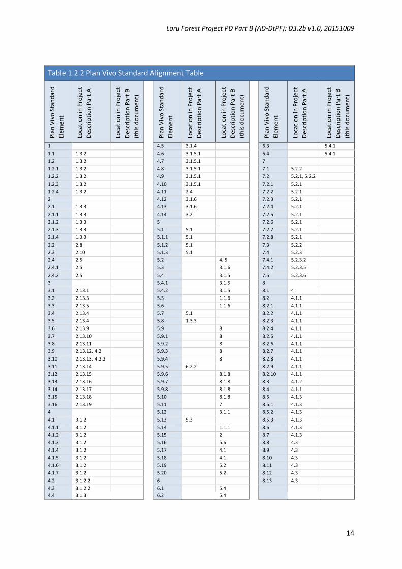
ThisProjectDescriptionPartB(whenusedincombinationwiththeProjectDescriptionPartA) aligns to every element of the Plan Vivo Standard (2013) as depicted in the followingtable. Note that this alignment includes elements that are located in the NakauMethodologyFramework.

LoruForestProjectPDPartB(AD-DtPF):D3.2bv1.0,20151009

14

Table1.2.2PlanVivoStandardAlignmentTable

Plan

VivoStan

dard

Elem

ent

Location

inProject

Description

PartA

Location

inProject

Description

PartB

(thisdo

cumen

t)

Plan

VivoStan

dard

Elem

ent

Location

inProject

Description

PartA

Location

inProject

Description

PartB

(thisdo

cumen

t)

Plan

VivoStan

dard

Elem

ent

Location

inProject

Description

PartA

Location

inProject

Description

PartB

(thisdo

cumen

t)

1 4.5 3.1.4 6.3 5.4.11.1 1.3.2 4.6 3.1.5.1 6.4 5.4.11.2 1.3.2 4.7 3.1.5.1 7 1.2.1 1.3.2 4.8 3.1.5.1 7.1 5.2.2 1.2.2 1.3.2 4.9 3.1.5.1 7.2 5.2.1,5.2.2 1.2.3 1.3.2 4.10 3.1.5.1 7.2.1 5.2.1 1.2.4 1.3.2 4.11 2.4 7.2.2 5.2.1 2 4.12 3.1.6 7.2.3 5.2.1 2.1 1.3.3 4.13 3.1.6 7.2.4 5.2.1 2.1.1 1.3.3 4.14 3.2 7.2.5 5.2.1 2.1.2 1.3.3 5 7.2.6 5.2.1 2.1.3 1.3.3 5.1 5.1 7.2.7 5.2.1 2.1.4 1.3.3 5.1.1 5.1 7.2.8 5.2.1 2.2 2.8 5.1.2 5.1 7.3 5.2.2 2.3 2.10 5.1.3 5.1 7.4 5.2.3 2.4 2.5 5.2 4,5 7.4.1 5.2.3.2 2.4.1 2.5 5.3 3.1.6 7.4.2 5.2.3.5 2.4.2 2.5 5.4 3.1.5 7.5 5.2.3.6 3 5.4.1 3.1.5 8 3.1 2.13.1 5.4.2 3.1.5 8.1 4 3.2 2.13.3 5.5 1.1.6 8.2 4.1.1 3.3 2.13.5 5.6 1.1.6 8.2.1 4.1.1 3.4 2.13.4 5.7 5.1 8.2.2 4.1.1 3.5 2.13.4 5.8 1.3.3 8.2.3 4.1.1 3.6 2.13.9 5.9 8 8.2.4 4.1.1 3.7 2.13.10 5.9.1 8 8.2.5 4.1.1 3.8 2.13.11 5.9.2 8 8.2.6 4.1.1 3.9 2.13.12,4.2 5.9.3 8 8.2.7 4.1.1 3.10 2.13.13,4.2.2 5.9.4 8 8.2.8 4.1.1 3.11 2.13.14 5.9.5 6.2.2 8.2.9 4.1.1 3.12 2.13.15 5.9.6 8.1.8 8.2.10 4.1.1 3.13 2.13.16 5.9.7 8.1.8 8.3 4.1.2 3.14 2.13.17 5.9.8 8.1.8 8.4 4.1.1 3.15 2.13.18 5.10 8.1.8 8.5 4.1.3 3.16 2.13.19 5.11 7 8.5.1 4.1.3 4 5.12 3.1.1 8.5.2 4.1.3 4.1 3.1.2 5.13 5.3 8.5.3 4.1.3 4.1.1 3.1.2 5.14 1.1.1 8.6 4.1.3 4.1.2 3.1.2 5.15 2 8.7 4.1.3 4.1.3 3.1.2 5.16 5.6 8.8 4.3 4.1.4 3.1.2 5.17 4.1 8.9 4.3 4.1.5 3.1.2 5.18 4.1 8.10 4.3 4.1.6 3.1.2 5.19 5.2 8.11 4.3 4.1.7 3.1.2 5.20 5.2 8.12 4.3 4.2 3.1.2.2 6 8.13 4.3 4.3 3.1.2.2 6.1 5.4 4.4 3.1.3 6.2 5.4

LoruForestProjectPDPartB(AD-DtPF):D3.2bv1.0,20151009

15

2. Identifying GHG Sources, Sinks and Reservoirs AccordingtoSection5ofthePlanVivoStandard(2013,p18):

5.15. All carbon pools and emissions sources used to quantify climate services must bespecifiedwithjustificationfortheirinclusion.Carbonpoolsexpectedtodecrease,andemissionssourcesexpectedtoincreaseasaresultoftheprojectinterventionmustbeincluded,unlessdecreasesoremissionsarelikelytobeinsignificant,i.e.lessthan5%oftotalclimatebenefits.

Section5.3oftheISO14064-2Standardrequiresprojectproponentsto:

Selectorestablishcriteriaandprocedures for identifyingandassessingGHGsources, sinksandreservoirscontrolled,relatedto,oraffectedbytheproject.

Basedonselectedorestablishedcriteriaandprocedures,theprojectproponentshallidentifyGHGsources,sinksandreservoirsasbeing:

a) Controlledbytheprojectproponent,b) RelatedtotheGHGproject,orc) AffectedbytheGHGproject.

Section5.5oftheISO14064-2Standardrequiresprojectproponentsto:

[Identify]GHGsources,sinksandreservoirsrelevanttothebaselinescenario,andforeach

a) Consider criteria and procedures used for identifying the GHG sources, sinks andreservoirsrelevantfortheproject,

b) If necessary, explain and apply additional criteria for identifying relevant baselineGHGsources,sinksandreservoirs,and

c) Compare the project's identified GHG sources, sinks and reservoirs with thoseidentifiedinthebaseline.

Section5.6oftheISO14064-2Standardrequiresprojectproponentsto:

Select or establish criteria and procedures for selecting relevant GHG sources, sinks andreservoirsforeitherregularmonitoringorestimation.

JustifynotselectinganyrelevantGHGsource,sinkandreservoirforregularmonitoring.

LoruForestProjectPDPartB(AD-DtPF):D3.2bv1.0,20151009

16

CriteriaForSelectingRelevantGHGSources,SinksandReservoirs

The GHG sources, sinks and reservoirs estimated in this project are restricted to LULUCFsectorcarbonemissionsandremovalsasfollows:

Table3a:GHGSources,Sinks,andReservoirs:PacificREDD+Program

CO2eemissionsfromabovegroundwoodybiomassremovedfromtheforest.CO2eemissionsfromabovegroundwoodybiomassenteringthedeadwoodpoolintheformofdiscardedcrownandbranchesofharvested(target)trees.CO2eemissionsfromadditionstotheabovegrounddeadwoodcarbonpoolresultingfromcollateraldamagetonon-targettreesduetowoodharvestactivities.

Sources

CO2eemissionsfromthedecompositionofbelowgroundbiomassresultingfromabovegroundwoodharvestingandcollateraldamage.CO2esequesteredinthenaturalbackgroundrateofnaturalforestregeneration.SinksCO2esequesteredinharvestpatchesasaconsequenceoftheopeningtheforestcanopy.

Reservoirs TheGHGassessmentinthisprojectestimatesthechangeincarbonstockscontainedincarbonreservoirs(andassociatedemissionsand/orremovals),ratherthanthetotalcontentofcarbonstoredintheforestcarbonreservoirs/pools.

The total volume of carbon stored in the above ground carbon pools ismeasured in thisprojectbymeansofacarbonstockinventory.Carbonstoredbelowgroundisderivedfromtheapplicationofaroot-shootratio.Furthermore,theGHGsourcesandsinksestimatedinthisprojectarerestrictedtoLULUCFcarbonpoolsthatarecontrolledbytheProjectOwnersandliewithintheEligibleForestAreaoftheproject.

Thecarbonpoolsusedinthisprojectare:

Table3b:CarbonPoolsUsedinthisMethodology

CarbonPool Included/Excluded

Justification

Abovegroundbiomass(AGB)

Included Ataminimum,thestockchangeintheabove-groundtreebiomassshallbeestimated.

Belowgroundbiomass(BGB)

Included Whenyoukillatreeyoualsokillitsroots(unlessthetreeisofaspeciesthatcoppices).The2006IPCCGuidelinesonGHGInventoriesusesaBGBdefaultvalueof0.37ofAGBfortropicalrainforest.Theonlyexceptiontothisdefaultruleforthismethodologyappliestospeciesthatareknowntobecapableofregeneratingfromcutstumps.ProjectCoordinatorsshallidentifytheproportionoftheabovegroundbiomassemitted(AGBE)attributabletothesespeciesintheBaseline,andremovethebelowgroundbiomassemitted(BGBE)portionforthesespeciesinthebaselinecalculation.

LoruForestProjectPDPartB(AD-DtPF):D3.2bv1.0,20151009

17

Dead-wood(DW) Included RequiredunderVCSToolforAFOLUMethodologicalIssues.

HarvestedWoodProducts Included RequiredunderVCSToolforAFOLUMethodologicalIssues, even though harvested wood products areusuallynotconsideredwhenestimatingthebaselineor project scenarios under the Plan Vivo Standardsfor RED projects (Estrada (CIFOR) 2011, p49).Included in this methodology to maintainconsistencywiththeVCSonthispoint.

Litter Excluded Insignificantandexclusionisconservative.Soilorganiccarbon Excluded Exclusionisconservative.

Theinclusion/exclusionofgreenhousegasesinthisprojectareshowninTable3c.

Table3c:Emissionsourcesotherthanresultingfromchangesinstocksincarbonpools

Gas Sources Included/Excluded

Justification

Removalofwoodyvegetationthroughcommercialloggingactivity

Included SuchremovalofvegetationcausesCO2

emissionstotheatmosphere.

Combustionoffossilfuels(invehicles,machineryandequipment)

Excluded NotrequiredbyPlanVivoStandards.

Carbondioxide(CO2)

Removalofherbaceousvegetation Excluded BasedonCDMEBdecisionreflectedinparagraph11ofthereportofthe23rdsessionoftheboard:cdm.unfccc.int/Panels/ar/023/ar_023_rep.pdf

Combustionoffossilfuels(invehicles,machineryandequipment)

Excluded NotrequiredbyPlanVivoStandards.Methane(CH4)

Burningofbiomass Excluded Exclusionisconservative.

Combustionoffossilfuels(invehicles,machineryandequipment)

Excluded NotrequiredbyPlanVivoStandards.

Nitrogenbasedfertilizer Excluded Potentialemissionsareconservativelyneglected.

Nitrousoxide(N2O)

Burningofbiomass Excluded Potentialemissionsareconservativelyneglected.

ComparisonBetweenBaseline&Project

The sources, sinks and reservoirs defined in the baseline scenario are the same for theprojectscenario.

LoruForestProjectPDPartB(AD-DtPF):D3.2bv1.0,20151009

18

3. Determining The Baseline Scenario Section5.4oftheISO14064-2Standardrequiresprojectproponentsto:

1.Selectorestablishcriteriaandproceduresforidentifyingandassessingpotentialbaselinescenariosconsideringthefollowing:

a) The project description, including identifiedGHG sources, sinks and reservoirs ([seeSection3above]);

b) Existingandalternativeprojecttypes,activitiesandtechnologiesprovidingequivalenttypeandlevelofactivityofproductsorservicestotheproject;

c) Dataavailability,reliabilityandlimitations;d) Other relevant information concerning present or future conditions, such as

legislative, technical, economic, socio-cultural, environmental, geographic, site-specificandtemporalassumptionsorprojections.

2. Demonstrate equivalence in type and level of activity of products or services providedbetween the project and the baseline scenario and shall explain, as appropriate, anysignificantdifferencesbetweentheprojectandthebaselinescenario.

3.Selectorestablish,explainandapplycriteriaandproceduresforidentifyingandjustifyingthebaselinescenario.

4.[Develop]thebaselinescenario,theprojectproponentshallselecttheassumptions,valuesandprocedures thathelpensure thatGHGemissions reductionsor removalenhancementsarenotover-estimated.

Baseline activities for this project are restricted to deforestation3 implemented on forestlands4andareincludedintheIPCCcategory“forestlandconvertedtonon-forestland”.

Onlyareasthathavebeendesignated,sanctionedorapprovedforsuchactivities(e.g.wherethereislegalsanctiontodeforest)bythenationaland/orlocalregulatorybodiesareeligibleforcreditingunderthisproject.

3UsingtheFAOFRA2010definition(seeExplanatoryNotesinAppendix1).

4UsingtheFAOFRA2010definition: Landspanningmorethan0.5hectareswithtreeshigherthan5metersandacanopycoverofmorethan10percent,ortreesabletoreachthesethresholdsinsitu.Itdoesnotincludelandthatispredominantlyunderagriculturalorurbanlanduse.Source:http://www.fao.org/docrep/014/am665e/am665e00.pdf

LoruForestProjectPDPartB(AD-DtPF):D3.2bv1.0,20151009

19

3.1 BASELINE SELECTION, ADDITIONALITY AND BASELINE MODELLING

3.1.1 Selection of Baseline

AccordingtothePlanVivoStandard(2013,p17):

5.12. A baseline scenario must be provided for each project intervention, describingcurrentlandusesandhabitattypesandexistingmajorecosystemservicesprovidedinthearea,andhowthesearemostlikelytochangeoverthequantificationperiodintheabsenceofprojectinterventions.

Thebaselinescenarioforeachlandparcelinthisprojectisdeforestation.

AccordingtotheTSModule(C)2.1(AD-DtPF)D2.2.1v1.020150815:

InjustifyingtheBaselineActivity,ProjectCoordinatorsmustdeterminethemostlikelylanduseintheabsenceoftheproject,throughtheidentificationofpossiblelandusesusingthefollowingcriteria,andanassessmentoflanduseoptionsaccordingtothefollowingcriteria:

a. Landsuitabilityb. Technicalbarriersc. Economicbarriersd. Institutionalconstraints

Themostlikelylanduseintheabsenceoftheprojectisdeforestationandlandconversiontococonutplantations incombinationwithcattlegrazing.This landuse is theprevalent landuseinthelandssurroundingtheProjectAreaandisthemostcommonlanduseineasternSanto, Vanuatu. The land is suitable to the baseline activity in terms of aspect, soils, andtopographyasevidencedbythelanduseinlandssurroundingtheProjectArea.

Therearenotechnicalbarrierstodeforestationattheprojectsitebecausethelandisonflatterrain,isaccessiblebyroadandhasbeenloggedinthepast.

Therearenoeconomicbarriers todeforestationat theprojectsite. In fact theopposite istrue. There are economic incentives for deforestation given the need among the landowningcommunityforeconomicdevelopmentandtheexistingmarketsforcopraandbeef.

Therearenoinstitutionalconstraintstodeforestationattheprojectsite.

3.1.2 Justification of Selected Baseline

ThescaleofthebaselineactivityisrestrictedtodeforestationoftallindigenousforestattheprojectsitelocatedinZoneA(seeFigure2.4cofthePDPartA).Baselinedeforestationalso

LoruForestProjectPDPartB(AD-DtPF):D3.2bv1.0,20151009

20

extendstoZoneB(Figure2.4c)butZoneBwasnotsubjectedtoaninventorysurveyduringproject development. For this reason Zone B is not included in carbon accounting at firstverification.Thebaselineemissionsassertionatfirstverificationwillthereforecompriseanunderestimationof the full scaleof baselineemissions. Forest inventory surveyof ZoneBfollowingfirstverificationwillenableinclusionofZoneBinbaselineemissionscalculations.

Baselineactivitiesatthescaledescribedaboveissupportedbylegalsanctiontodeforest.

The commercial viability of the baseline activity at the scale of the baseline scenarioassertion(deforestationofZoneAandB)isevidencedbythescaleofequivalentactivitiesonlandssurroundingtheProjectArea(seeFigure2.4.3inPDPartA).

3.1.2.1 Commercially Viable Baseline

AccordingtotheTSModule(C)2.1(AD-DtPF)D2.2.1v1.020150815:

Projectsarealso required toundertakeaneconomicanalysis forestablishing the scaleofbaselineactivityanddemonstratingthatthebaselineactivityiscommerciallyviable.

ThisTechnical SpecificationsModuleestablishes thebaselineonhistoricalactivities in theproject and/or reference area, so is similar to making the assumption that the baselinescenariowillcontinuefortheProjectPeriod.ProjectCoordinatorsarerequiredtoupdatethebaselineeverytenyearsfromtheProjectStartDate.

Economicanalysisofthebaselinescenarioundertakenduringprojectdevelopmentisbasedonthefollowingassumptions:

• 50% of the adult population participates in baseline copra production earningVUV12,000permonth.

• Adultpopulation:approximately50peopleavailableforcopralabourbutonlyhalfoftheseparticipatingincopraproduction.

• SerakarClanunlikely to inviteexternal labour towork their land thus reducing thelabourpooltoSerakarClanadults.

These results yield anticipated annual aggregated revenues from copra production atUS$33,442. Initial costs of deforestation and plantation establishmentwould be offset bytimberrevenues.Netpositivecoprarevenueswouldbeginafter5yearsbutbesupportedbyrevenue generation from beef grazing from the year following deforestation in landsallocatedtobeefgrazing.

Thisanalysisshowsthatcopraproductioncombinedwithbeefgrazingandtimberrevenuesiscommerciallyviableasthebaselinescenario.

LoruForestProjectPDPartB(AD-DtPF):D3.2bv1.0,20151009

21

3.1.3 Justification for Excluding Alternative Baselines

Possiblealternativebaselines:

ForestProtection

This is not likely given theneed for economicdevelopment among the landowners in theSerakarClanwhoseeconomicdevelopmentneedsareunabletobemetunderexistinglandusearrangements.Notealsothatallneighbouringlandownergroupshavegreateraccesstoeconomicdevelopmentbecausetheyhavecopraplantationsandbeefgrazinglandsinsteadoftallrainforest.

Deforestationbutnotcopraandbeef

Alternative baselines that also involve deforestation are unlikely due to the smallholdernatureoflandtenureinthispartofVanuatuandthissiteinparticular.Forotherlargerscaleagriculturalactivities(e.g.oilpalm)largerlandaggregationswouldbenecessary.

3.1.4 Stratification

AccordingtotheTSModule(C)2.1(AD-DtPF)D2.2.1v1.020150815:

AllprojectsapplyingthisTechnicalSpecificationsModuleshallstratifythebaselinescenariointothefollowingstrata:

a. Forestcompositionstratification.b. Forestmanagementstratification.

Thisprojecthasthreestrata:

1. ZoneA=tallregeneratingcoastalrainforestdepictedasZoneAinFigure4.2cofthePDPartA.ZoneAisallocatedtoforestprotectionduringtheProjectPeriod.ZoneAislogged forestasdefined inSection3.1.4of theTechnicalSpecificationsModule (C)2.1(AD-DtPF):D2.2.1v1.0,20150815.

2. ZoneB=degradedregeneratingcoastalrainforestdepictedasZoneBinFigure4.2cofthePDPartA.ZoneB isallocatedtoforestprotectionduringtheProjectPeriod.Zone B is logged forest as defined in Section 3.1.4 of the Technical SpecificationsModule(C)2.1(AD-DtPF):D2.2.1v1.0,20150815.

3. Zone C = non-forest land. Zone C is allocated to agroforestry activities during theProjectPeriod.

3.1.5 Additionality

AccordingtoSection5ofthePlanVivoStandard(2013,p16):

5.4. Ecosystem services forming the basis of Plan Vivo projects must be additional i.e.

LoruForestProjectPDPartB(AD-DtPF):D3.2bv1.0,20151009

22

would not have been generated in the absence of the project,which involves as aminimumdemonstratingthat:

5.4.1. Projectinterventionsarenotrequiredbyexistinglawsorregulations,unlessitcanbeshownthatthose lawsarenotenforcedorcommonlymet inpracticeandthesupportoftheprojectisthereforejustified;

5.4.2. Therearefinancial,social,cultural,technical,scientificorinstitutionalbarrierspreventingprojectinterventionsfromtakingplace.

Accordingtosection5.4oftheISO14064-2standard(2006):

Theprojectproponentshallselectorestablish, justifyandapplycriteriaandproceduresfordemonstrating that the project results in GHG emissions reductions or removalenhancementsthatareadditionaltowhatwouldoccurinthebaselinescenario.

ThisProject tests theadditionalityof theprojectusingthemostrecentversionof theVCSAFOLUAdditionalityTool.TheAdditionalityAssessmentispresentedinAppendix10.

3.1.6 Baseline Revision

AccordingtoSection5.3ofthePlanVivoStandard(2013):

Technical specificationsmust be updated at least every 5 yearswhere they are still beingusedtosignnewPESAgreements,byreviewingbothavailabledatafromprojectmonitoringresults,e.g.speciesgrowthdata,andnewavailabledatafromoutsidetheproject.

All projects are required to undertake a baseline revision every 5 years. This baselinerevisionwill include revisionof the technicaldataused to create theBaselineandProjectScenariosfromanecosystemserviceaccountingperspective.

LoruForestProjectPDPartB(AD-DtPF):D3.2bv1.0,20151009

23

4. Quantifying Baseline GHG Emissions and Removals AccordingtoSection5ofthePlanVivoStandard(2013):

5.2. Sources of data used to quantify ecosystem services, including all assumptions anddefault factors,mustbe specifiedandasup-to-dateaspossible,witha justificationforwhytheyareappropriate.

5.18. Anapprovedapproachmustbeusedtoquantify initialcarbonstocksandemissionssources,andestimatehowtheyaremostlikelytochangeovertheprojectperiod,aspartofthebaselinescenario.

AccordingtoSection5.7oftheISO14064-2Standard:

Theprojectproponentshallselectorestablishcriteria,proceduresand/ormethodologiesforquantifying GHG emissions and/or removals for selected GHG sources, sinks and/orreservoirs(seeSection6above).

Based on selected or established criteria and procedures, the project proponent shallquantifyGHGemissionsand/orremovalsseparatelyfor

a) Each relevant GHG for each GHG source, sink and/or reservoir relevant for theproject,and

b) EachGHGsource,sinkand/orreservoirrelevantforthebaselinescenario.

When highly uncertain data and information are relied upon, the project proponent shallselect assumptions and values that ensure that the quantification does not lead to over-estimationofGHGemissionsreductionsorremovalenhancements.

TheprojectproponentshallestimateGHGemissionsand/orremovalsbyGHGsources,sinksandreservoirsrelevantfortheprojectandrelevantforthebaselinescenario,butnotselectedforregularmonitoring.

Theprojectproponentshallestablishandapplycriteria,proceduresand/ormethodologiestoassess the risk of a reversal of a GHG emission reduction or removal enhancement (i.e.permanenceofGHGemissionreductionorremovalenhancement).

Ifapplicable,theprojectproponentshallselectordevelopGHGemissionsorremovalfactorsthat:• arederivedfromarecognizedorigin,• areappropriatefortheGHGsourceorsinkconcerned,

LoruForestProjectPDPartB(AD-DtPF):D3.2bv1.0,20151009

24

• arecurrentatthetimeofquantification,• takeaccountofthequantificationuncertaintyandarecalculated inamanner intended

toyieldaccurateandreproducibleresults,and• areconsistentwiththeintendeduseoftheGHGreport.

This Technical SpecificationsModule calculates thenet anthropogenicGHGemissions andremovalsintheBaselineScenario,andthencalculatesthenetanthropogenicGHGemissionsandremovalsintheProjectScenario.

4.1 CALCULATION OF GHG EMISSIONS AND REMOVALS

The highest-level equation for carbon stock change measurement in this TechnicalSpecificationsModule for baseline and project scenarios is equivalent to Equation 2.3 ofVolume4,Chapter2ofthe2006IPCCGuidelinesforNationalGHGInventories:

Where: ∆CLUi = Carbon stock changes for a stratum of land-use category; and subscriptsdenote the followingcarbonpools:AB=AboveGroundLiveBiomass;BB=BelowGroundLiveBiomass;DW=Deadwood;LI=Litter;SO=Soils;HWP=HarvestedWoodProducts.

Annual carbon stock change calculations for baseline and project scenarios are based onEquation 2.7 (Chapter 2, Volume 4) of the IPCC 2006 Guidelines on National GHGInventories.

Where:∆CB=Annualchangeincarbonstocksinbiomass,(tonnesCyr-1);∆CG=Annualgain(removals)ofcarboninbiomassduetobiomassgrowthconsideringthetotalarea(tonnesCyr-1);∆CL=Annualloss(emissions)ofcarboninbiomassduetobiomasslossconsideringthetotalarea(tonnesCyr-1).

!"#$%&'()*(+&,&'-.(/&%"010203-&4(5$$2-.#62&(%0(/72%-$2&(8#,19:4&(!#%&30'-&4(

);;<(=>!!(+7-1&2-,&4(?0'(@#%-0,#2(+'&&,"074&(+#4(=,A&,%0'-&4( )BC(

!8( D(!'0$2#,1(

+8( D(+'#442#,1(

E8( D(E&%2#,14(

F8( D(F&%%2&G&,%4(

H8( D(H%"&'(8#,1(

(

I0'(&#."(2#,1974&(.#%&30'JK(.#'60,(4%0.L(."#,3&4(#'&(&4%-G#%&1(?0'(#22(!"#$"$(0'(4761-A-4-0,4(0?(2#,1(#'&#(M&B3BK(.2-G#%&( N0,&K( &.0%J$&K( 40-2( %J$&K( G#,#3&G&,%( '&3-G&( &%.BK( 4&&( !"#$%&'( OP( ."04&,( ?0'( #( 2#,1974&( .#%&30'J(MQR7#%-0,( )B)PB( ( !#'60,( 4%0.L( ."#,3&4(S-%"-,( #( 4%'#%7G( #'&( &4%-G#%&1( 6J( .0,4-1&'-,3( .#'60,( .J.2&( $'0.&44&4(6&%S&&,( %"&( ?-A&(.#'60,($0024K(#4(1&?-,&1( -,(T#62&(UBU( -,(!"#$%&'(UB(T"&(3&,&'#2-N&1( ?20S."#'%(0?( %"&(.#'60,(.J.2&(MI-37'&()BUP(4"0S4(#22(?-A&($0024(#,1(#440.-#%&1(?27V&4(-,.271-,3(-,$7%4(%0(#,1(07%$7%4(?'0G(%"&(4J4%&GK(#4(S&22(#4(#22($044-62&(%'#,4?&'4(6&%S&&,(%"&($0024B(HA&'#22K(.#'60,(4%0.L(."#,3&4(S-%"-,(#(4%'#%7G(#'&(&4%-G#%&1(6J(#11-,3(7$(."#,3&4(-,(#22($0024(#4(-,(QR7#%-0,()BOB((I7'%"&'K(.#'60,(4%0.L(."#,3&4(-,(40-2(G#J(6&(1-4#33'&3#%&1(#4(%0(."#,3&4(-,(!(4%0.L4(-,(G-,&'#2(40-24(#,1(&G-44-0,4(?'0G(0'3#,-.(40-24B(W#'A&4%&1(S001($'017.%4(MWE>P(#'&(#240(-,.271&1(#4(#,(#11-%-0,#2($002B(

(

!"#$%&'()*+*)$((#$,)-$./'()0%'-1)-2$(3!0)4'.)$),$(56#0!)-$%!3'.7)$0)$)0#8)'4)-2$(3!0)&()!$-2)

0%.$%#8)9&%2&()%2!)-$%!3'.7)����%

&'&' ()) (

E"&'&*(

�!8:((D(.#'60,(4%0.L(."#,3&4(?0'(#(2#,1974&(M8:P(.#%&30'J(#4(1&?-,&1(-,(QR7#%-0,()BUB(

%(( (((D(1&,0%&4( #( 4$&.-?-.( 4%'#%7G(0'( 4761-A-4-0,(S-%"-,( %"&( 2#,1974&(.#%&30'J( M6J(#,J(.0G6-,#%-0,(0?(4$&.-&4K(.2-G#%-.(N0,&K(&.0%J$&K(G#,#3&G&,%('&3-G&(&%.BK(4&&(!"#$%&'(OPK*%(D(U(%0(,B((

(

!"#$%&'()*+:)$((#$,)-$./'()0%'-1)-2$(3!0)4'.)$)0%.$%#8)'4)$),$(56#0!)-$%!3'.7)$0)$)0#8)'4)

-2$(3!0)&()$,,);'',0)

+,-./&(0,1121&' )))))))%

������������� (

E"&'&*(

�!8:%(D(.#'60,(4%0.L(."#,3&4(?0'(#(4%'#%7G(0?(#(2#,1974&(.#%&30'J(

F764.'-$%4(1&,0%&(%"&(?0220S-,3(.#'60,($0024*(

5X( D(#60A&93'07,1(6-0G#44(

XX( D(6&20S93'07,1(6-0G#44(

YE( D(1&#1S001(

8=( D(2-%%&'(

FH( D(40-24(

WE>(D("#'A&4%&1(S001($'017.%4(

(

Q4%-G#%-,3(."#,3&4(-,(.#'60,($0024(#,1(?27V&4(1&$&,14(0,(1#%#(#,1(G01&2(#A#-2#6-2-%JK(#4(S&22(#4('&407'.&4(#,1(.#$#.-%J(%0(.022&.%(#,1(#,#2JN&(#11-%-0,#2(-,?0'G#%-0,(MF&&(!"#$%&'(UK(F&.%-0,(UBOBO(0,(L&J(.#%&30'J(#,#2J4-4PB((T#62&(UBU(-,(!"#$%&'(U(07%2-,&4(S"-."($0024(#'&('&2&A#,%(?0'(&#."(2#,1974&(.#%&30'J(?0'(T-&'(U(G&%"014K(-,.271-,3(.'044( '&?&'&,.&4( %0( '&$0'%-,3( %#62&4B( ( Y&$&,1-,3( 0,( .07,%'J( .-'.7G4%#,.&4( #,1(S"-."( %-&'4( #'&( ."04&,K( 4%0.L(."#,3&4(G#J(,0%(6&(&4%-G#%&1(?0'(#22($0024(4"0S,(-,(QR7#%-0,()BOB( (X&.#74&(0?( 2-G-%#%-0,4(%0(1&'-A-,3(1&?#72%(1#%#(4&%4(%0(47$$0'%(&4%-G#%-0,(0?(40G&(4%0.L(."#,3&4K(T-&'(U(G&%"014(-,.271&(4&A&'#2(4-G$2-?J-,3(#447G$%-0,4*(

(

!"#$%&'()'*+,-.$#/$,&0'1",&2/,3'456'7/8&,'9456':2&'

;<=;' ;>>?'@ABB'C$-6&#-5&2'D",'E4/-"54#'C,&&58"$2&'C42'@5F&5/",-&2'

!"#"$"$% &'()%*+,'-(-(.%-(%'%&'()/01+%2'3+.4*5%

GH$4/-"5';<I'-5.#$6&2'/8&'D-F&'.4,J"5'K""#2'D",'L8-.8'2/".M'.845+&'&2/-%4/&2'4,&',&H$-,&6<'N8-2'2&./-"5'K,&2&5/2'

%&/8"62'D",'&2/-%4/-5+'J-"%422'.4,J"5'+4-520'#"22&2'456'5&/'.845+&2<'C4-52'-5.#$6&'J-"%422'+,"L/8'-5'4J"F&O

+,"$56'456'J&#"LO+,"$56'."%K"5&5/2<'9"22&2'4,&'.4/&+",-P&6'-5/"'L""6'D&##-5+2'",'84,F&2/0'D$&#L""6'+4/8&,-5+0'

456'#"22&2'D,"%'54/$,4#'6-2/$,J45.&2'"5'%454+&6'#456'2$.8'42'D-,&0'-52&./'"$/J,&4M2'456'&Q/,&%&'L&4/8&,'&F&5/2'

R&<+<0'8$,,-.45&20'D#""6-5+S<'NL"'%&/8"62'4,&'K,"F-6&6'D",'&2/-%4/-5+'.4,J"5'2/".M'.845+&2'-5'J-"%422<''

367% .89:/&;<<% ,7=6;>' ,&H$-,&2' /8&' J-"%422' .4,J"5' #"22' /"' J&' 2$J/,4./&6' D,"%' /8&' J-"%422' .4,J"5' +4-5'RGH$4/-"5' ;<TS<' N8-2' $56&,K-52' /8&' N-&,' ='%&/8"60' D",'L8-.8' 6&D4$#/' F4#$&2' D",' .4#.$#4/-"5' "D' -5.,&%&5/' 456'

#"22&2' 4,&' K,"F-6&6' -5' /8-2' !"#$%&' /"' &2/-%4/&' 2/".M' .845+&2' -5' J-"%422<' U-+8&,' /-&,' %&/8"62' $2&' ."$5/,3O

2K&.-D-.'64/4'/"'&2/-%4/&'+4-5'456'#"22',4/&2<'1",'4##'/-&,20'/8&2&'&2/-%4/&2',&H$-,&'."$5/,3O2K&.-D-.'4./-F-/3'64/40'

4#/8"$+8'D",'N-&,'=0'/8&2&'64/4'.45'J&'"J/4-5&6'D,"%'+#"J4##3O."%K-#&6'64/4J42&2'R&<+<0'1*7'2/4/-2/-.2S<'

'

+?0'3-4(%!"@%'((0'&%2A'(.+%-(%2'*B4(%1342C1%-(%B-4,'11%%

-(%&'()%*+,'-(-(.%-(%'%D'*3-20&'*%&'()/01+%2'3+.4*5%E.'-(/&411%,+3A4)F%

!"# $$$ ����� '

V8&,&)'

�BW'X'455$4#'.845+&'-5'.4,J"5'2/".M2'-5'J-"%422'R/8&'2$%'"D'4J"F&O+,"$56'456'J&#"LO+,"$56'J-"%422'

/&,%2'-5'GH$4/-"5';<IS'D",'&4.8'#456'2$JO.4/&+",30'."52-6&,-5+'/8&'/"/4#'4,&40'/"55&2'B'3,O=''

�BC'X'455$4#' -5.,&42&'-5'.4,J"5'2/".M2'6$&'/"'J-"%422'+,"L/8'D",'&4.8'#456'2$JO.4/&+",30'."52-6&,-5+'

/8&'/"/4#'4,&40'/"55&2'B'3,O='

�B9'X'455$4#'6&.,&42&'-5'.4,J"5'2/".M2'6$&'/"'J-"%422'#"22'D",'&4.8'#456'2$JO.4/&+",30'."52-6&,-5+'/8&'

/"/4#'4,&40'/"55&2'B'3,O='

N8&' .845+&2' -5' B' 2/".M' -5' J-"%422' D",' #456' ,&%4-5-5+' -5' /8&' 24%&' #456O$2&' .4/&+",3' R&<+<0' %&'()*+ !,-.+/(0,1-1-2+%&'()*+!,-.S'4,&'J42&6'"5'&2/-%4/&2'"D'455$4#'+4-5'456'#"22'-5'J-"%422'2/".M2<'B"$5/,-&2'$2-5+'453'"D' /8&' /8,&&' /-&,2' .45' 46"K/' /8-2' %&/8"6<' N8-2' %&/8"6' .45' J&' $2&6' J3' ."$5/,-&2' /84/' 6"' 5"/' 84F&' 54/-"54#'

-5F&5/",3'232/&%2'6&2-+5&6'D",'&2/-%4/-5+'L""63'J-"%422'2/".M2<'Y&D4$#/'64/4'4,&'K,"F-6&6'-5'#456O$2&'.4/&+",3'

.84K/&,2' D",' -5F&5/",3'."%K-#&,2'L8"'6"'5"/'84F&'4..&22' /"'."$5/,3O2K&.-D-.'64/4<'V",M28&&/2'84F&'4#2"'J&&5'

6&F&#"K&6'$2-5+'/8&'%&/8"62'456'&H$4/-"52'R*55&Q'=S<''

367'1=;GH/)9II7J7:G7%,7=6;>',&H$-,&2'J-"%422'.4,J"5'2/".M'-5F&5/",-&2'D",'4'+-F&5'#456'4,&40'4/'/L"'K"-5/2'-5'/-%&<'*55$4#'J-"%422'.845+&'-2'/8&'6-DD&,&5.&'J&/L&&5'/8&'J-"%422'2/".M'4/'/-%&'/

;'456'/-%&'/

=0'6-F-6&6'J3'/8&'

5$%J&,'"D'3&4,2'J&/L&&5'/8&'-5F&5/",-&2'RGH$4/-"5';<ZS<''@5'2"%&'.42&20'K,-%4,3'64/4'"5'J-"%422'%43'J&'-5'/8&'

D",%'"D'L""6'F"#$%&'64/40'D",'&Q4%K#&0'D,"%'D",&2/'2$,F&320'-5'L8-.8'.42&'D4./",2'4,&'K,"F-6&6'/"'."5F&,/'L""6'

F"#$%&'/"'.4,J"5'%422'$5-/20'42'28"L5'-5'GH$4/-"5';<Z<J<'

'

+?0'3-4(%!"K%'((0'&%2A'(.+%-(%2'*B4(%1342C1%-(%B-4,'11%%

-(%&'()%*+,'-(-(.%-(%3A+%1',+%&'()/01+%2'3+.4*5%E1342C/)-LL+*+(2+%,+3A4)F%

SR

SR

=;

=;

**$$

$ **# �

��� '' ' ' ' R4S'

L8&,&'

� ������31

313143131 $%/#$5%67$31

0

0000 [S=R\0

' RJS'

V8&,&)'

�BW'X'455$4#'.845+&'-5'.4,J"5'2/".M2'-5'J-"%422'R/8&'2$%'"D'4J"F&O+,"$56'456'J&#"LO+,"$56'J-"%422'

/&,%2'-5'GH$4/-"5';<I'S'-5'#456',&%4-5-5+'-5'/8&'24%&'.4/&+",3'R&<+<0'%&'()*+!,-.+/(0,1-1-2+%&'()*+!,-.S0'/"55&2'B'3,O=+

B'/;' X'/"/4#'.4,J"5'-5'J-"%422'D",'&4.8'#456'2$JO.4/&+",3'4/'/-%&'/

;0'/"55&2'B''

LoruForestProjectPDPartB(AD-DtPF):D3.2bv1.0,20151009

25

ThefollowingtableliststhebaselineGHGsourcesandsinksmodelledbythismethodology:

Table4.1:BaselineGHGSourcesandSinks Acronym

IncludedinModelling: AboveGroundBiomassEmittedasaresultofbaselinedeforestation AGBEBelowGroundBiomassEmittedasaresultofbaselineactivity BGBERemovalssequesteredintothelong-termwoodproductpool ltWPResidualLiveBiomassinpostdeforestationwoodyvegetation RLBPDExcludedfromModelling: Emissionsfromfossilfuelcomponentsofbaselineactivity

Calculation of Baseline Scenario carbon dioxide emissions and removals involves theapplicationoftheequationspresentedinthissectionofthismethodologytocompletethecarbon accounting for all land parcels in the Baseline Scenario. The baseline and projectemissions and removal calculations are based on conservative default values applied toempiricalmeasurementofbaselinetimberharvestingrates.

AccordingtoSection5ofthePlanVivoStandard(2013,p18):

5.17. Whereclimateservicesareaffectedbycyclicalmanagementactivity,e.g.harvestingornaturallyoccurringcycles,thequantificationperiodmustberepresentativeoftheservicesprovidedthroughoutthefullcycleofevents.

4.1.1 Step 1 – Above Ground Biomass Emitted (AGBE)

This project applied the field inventory methodology specified in Section 4.1.1 of theTechnicalSpecificationsModule(C)2.1(AD-DtPF):D2.2.1v1.0,20150815.

AGBEwasestimatedusingtheallometricequationrecommendedbyChaveetal.(2005)formoisttropicalforests(Equation.4.1.1a).

Equation 4.1.1.7a: AGBEsi=exp(−2.977+ln(ρD

2H))=0.0509×ρD2H

ParametersAGBEsi Abovegroundlivebiomasswithinsampleplotforstratumi(m3yr-1)

D Stemdiameteratbreastheightwithinsampleplot(cm)H Topheightofsampledtree(m)derivedfromadiameter-heightequationρ Densityofsampledtreewood(g/cm3)derivedfromregionaldefaults.

AGBE = 39,419 m3 aggregated for the Project Period (i.e. this number is not an annualnumber – carbon accounting is annualised in Step 4.1.5 in this project). See Appendix 5,sheetLoruCarbon.

Diameter–HeightRatio

Tree height (H in Equation 4.1.1.7a) estimations for each tree measured in the forest

LoruForestProjectPDPartB(AD-DtPF):D3.2bv1.0,20151009

26

inventoryisprovidedinAppendix5,sheet‘LoruForestInventory–Tree’,columnG.

Stemheight-diametercurvesforthisprojectwerecalculatedasfollows:

Method

Moststandardtwo-parameterheight-diameter functions listed inHuschetal. (2003)weretested. Curves were fitted with non-linear mixed effect models using the nlme function(Pinheiroetal.2015)intheRstatisticalpackagewithrandomcoefficientsforspecies.

Results

Onlyasubsetofthoseequationstestedispresentedbelow.Modelfitsanddiagnosticsforthemodelswithstrongsupport(eq.1-3)andforanallometricequationofstandarduse,butwithpoorsupport(eq.4)areshowninthetable.Theparametersreportedforeach:

Equation estimated AICc !2adjusted slopeobsvs.predicted Source

" #

1 2.465118 0.174846 293.2 0.81 1.015 a.2 0.249432 2.588026 293.5 0.80 1.007 a.3 32.59106 37.81761 294.2 0.81 1.082 b.4 21.30214 0.049395 304.4 0.77 1.092 d.Sources:a.Prodan1997,Huschetal.2003;b.BatesandWatts1980;c.Thomas1996

Equation

eq. 1 ܪ ൌ ଶሺ� �� ൈ �ሻଶ � �ͳǤ͵ͷ

eq. 2 ܪ ൌ �ͳǤ͵ͷ� �൬� �

൰ଶǤହ

eq. 3 ܪ ൌ � ൈ �� � �� ͳǤ͵ͷ

eq. 4 ܪ ൌ ͳǤ͵ͷ ሺ െ ͳǤ͵ͷሻሺͳ െ �ൈௗሻ

LoruForestProjectPDPartB(AD-DtPF):D3.2bv1.0,20151009

27

Figure4.1.1.7aiTreeheight–diametercurve,LoruForest

Figure4.1.1.7aiiBestsupportedmodel(eq.1)

Interpretation

Equations1,2and3haveequivalentstatisticalsupport(AICcvalues).Thefigureshowsthatthecurvesforeq.1andeq.2overlapandarealmostidenticaltoeachother.Eq.3tendstoestimate taller height for small trees and lower heights for larger trees. That tendency isevenmoremarkedwitheq.4,whichclearlygetslowerstatisticalsupportcomparedtotheother equations. Accordingly, equation 1 was applied in this project (replacing Equation4.1.1.7bintheTechnicalSpecificationsModule(C)2.1(AD-DtPF):D2.2.1v1.0,20150815).

LoruForestProjectPDPartB(AD-DtPF):D3.2bv1.0,20151009

28

Equation 4.1.1.7b: Height(Indigenousforestspecies)=1.52×DBH

0.31

ParametersDBH Stemdiameteratbreastheightwithinsampleplot(cm)

WoodDensity

Wooddensitymeasuredin(g/cm3).Wooddensityiscalculatedforeachspeciesmeasuredintheforestinventory(Appendix5,sheet‘LoruForestInventory–Tree’columnH).

AboveGroundDeadBiomass(AGDB)

ThecalculationofAboveGroundDeadBiomass(AGDB)isnotmeasuredinthisproject.

4.1.2 Step 2 – Below Ground Biomass Emitted (BGBE)

BelowGroundBiomassEmitted(BGBE) inthisprojectusesthe IPCCratioofbelow-groundbiomasstoabovegroundbiomassfortropicalrainforestof0.375.Thedefaultfactorusedinthismethodologyis0.37ofAGBEandiscalculatedusingthefollowingequation:

Equation 4.1.2: BGBE=AGBEx0.37

ParametersBGBE BelowgroundbiomassemittedwithinEFA(m3yr-1)AGBE AbovegroundbiomassemittedwithinEFA(m3yr-1)

Belowgroundbiomassforthisprojectis:

39,419x0.37=23,151m3yr-1

(SeeAppendix5LoruCarbonBudget&Pricing,sheetLoruCabon,cellE5)

4.1.3 Step 3 – Total Emitted Wood Volume in Cubic Metres (TM3)

TotalEmittedWoodVolumeincubicmeters(TM3)representsthevolumeofabovegroundandbelow-groundlivewoodvolumethatisemittedasaresultofdeforestation.

5IPCC2006.2006IPCCGuidelinesonNationalGreenhouseGasInventories.Vol.4Ch4.p49.

LoruForestProjectPDPartB(AD-DtPF):D3.2bv1.0,20151009

29

TM3iscalculatedusingthefollowingequation:

Equation 4.1.3: TM3=AGBE+BGBE

ParametersTM3 TotalemittedwoodvolumeincubicmeterswithinEFA(m3yr-1)AGBE AbovegroundbiomasswithinEFA(m3yr-1)BGBE BelowgroundbiomasswithinEFA(m3yr-1)

TM3forthisprojectis:

TM3=39,419+23,151=62,570m3yr-1

(SeeAppendix5LoruCarbonBudget&Pricing,sheetLoruCabon,cellE6.)

4.1.4 Step 4 – Gross Total Emissions in tCO2e (GTCO2)

AccordingtoTSModule(C)2.1(AD-DtPF)D2.2.1v1.020150815:

Gross Total Emissions in tCO2e from deforestation (GTCO2) is calculated by means ofconverting TM3 (cubicmeters) to tCO2e using the following procedure:

6 The estimation ofgreenhouse gases that would result from the combustion or decomposition of wood iscalculatedinthefollowingthreestepsasspecifiedinthismethodology:

1. Convertgreenwoodvolumetodrytonnesofwood2. Convertdrytonnesofwoodtocarbon3. Convertcarbontocarbondioxide

This project calculated GTCO2 by means of applying equations in Section 4.1.4 of theTechnical Specifications Module (C) 2.1 (AD-DtPF): D2.2.1 v1.0, 20150815). The result ofthesecalculationscanbefoundinAppendix5,LoruForestInventory,Sheet‘CarbonStocks–SlopeCorrected’,cellH28,andAppendix5,LoruCarbonBudget&Pricing,Sheet‘LoruPHI’,cellF31(derivingthelatterbymultiplyingtheformerbytheeligibleforestarea).

GTCO2=53,862 tCO2e (one-off inbaselinedeforestation) and later adjusted toanannualbaselineemissioninthecalculationofGrossBaselineEmissionsAvoided(GBEA)below.

6FromIPCC(2006)Vol4.Ch2.p11(section2.2.3)

LoruForestProjectPDPartB(AD-DtPF):D3.2bv1.0,20151009

30

4.1.4a Convert Green Wood Volume To Dry Tonnes Of Wood

WooddensitycalculationscanbefoundinAppendix5,‘LoruForestInventory’,Sheet‘WoodDensity’, Column E; Sheet ‘CarbonDataset’ (columnH); and Sheet ‘Carbon Calculations –Tree’,ColumnI.

Themeanwooddensityforthisforestwascalculatedas=0.479,althoughhigherresolutionspecies-specificwooddensitycalculationswereappliedinthecalculationofGTCO2forthisproject.

4.1.4b Calculate Carbon Content Of Dry Wood

Carbon fraction calculations for this project can be found in Appendix 5 Loru ForestInventory,Sheet‘CarbonCalculations–Tree’,ColumnQ.

4.1.5 Step 5 – Gross Baseline Emissions (GBEWP)

GrossBaselineEmissionsoverthe30yearprojectperiodassumingadeforestationeventatthestartof thebaselineperiod,andtaking intoaccountcarbonsequestered into the longterm Wood Products pool (GBEWP) is calculated using the methodology presented inSection 4.1.5 of the Technical Specifications Module (C) 2.1 (AD-DtPF): D2.2.1 v1.0,20150815).

GBEWP=52,808tCO2e (one-off inbaselinedeforestation)and lateradjustedtoanannualbaselineemissioninthecalculationofGrossBaselineEmissionsAvoided(GBEA)below.

(SeeAppendix5,SheetLoruCarbon,CellE8.)

4.1.6 Step 6 – Sequestration into Long Term Wood Products (ltWP)

Removalssequesteredintothelong-termWoodProductspool(ltWP)iscalculatedusingthemethodologypresentedinSection4.1.6oftheTechnicalSpecificationsModule(C)2.1(AD-DtPF):D2.2.1v1.0,20150815).

ltWP = 1,054 tCO2e (one-off in baseline deforestation) and later adjusted to an annualbaselineemissioninthecalculationofGrossBaselineEmissionsAvoided(GBEA)below.

(SeeAppendix5,SheetLoruCarbon,CellO20.)

4.1.7 Step 7 – Gross Baseline Emissions Avoided (GBEA)

GrossBaselineEmissionsAvoided(GBEA)iscalculatedusingthemethodologypresentedinSection 4.1.7 of the Technical Specifications Module (C) 2.1 (AD-DtPF): D2.2.1 v1.0,20150815).

GBEA=1,760tCO2eyr-1

LoruForestProjectPDPartB(AD-DtPF):D3.2bv1.0,20151009

31

(SeeAppendix5,SheetLoruCarbon,CellE9.)

4.1.8 Step 8 – Baseline Removals (BR)

BaselineRemovals(BR)iscalculatedusingthemethodologypresentedinSection4.1.8oftheTechnicalSpecificationsModule(C)2.1(AD-DtPF):D2.2.1v1.0,20150815).

BR=34tCO2eyr-1

(SeeAppendix5,SheetLoruCarbon,CellE10.)

4.1.9 Step 9 – Net Baseline Emissions Avoided (NBEA)

Net Baseline Emissions Avoided (NBEA) is calculated using themethodology presented inSection 4.1.9 of the Technical Specifications Module (C) 2.1 (AD-DtPF): D2.2.1 v1.0,20150815).

NBEA=1,726tCO2eyr-1

(SeeAppendix5,SheetLoruCarbon,CellE11.)

4.1.10 Baseline Scenario Variants

ThisprojectappliesVariant2(LoggedForest)ofthebaselinescenariovariantspresentedinSection 4.1.10 of the Technical Specifications Module (C) 2.1 (AD-DtPF): D2.2.1 v1.0,20150815).

LoruForestProjectPDPartB(AD-DtPF):D3.2bv1.0,20151009

32

5. Quantifying Project Emission Reductions & Removal Enhancements AccordingtoSection5ofthePlanVivoStandard(2013):

5.2. Sources of data used to quantify ecosystem services, including all assumptions anddefault factors,mustbe specifiedandasup-to-dateaspossible,witha justificationforwhytheyareappropriate.

AccordingtoSection5.8oftheISO14064-2Standard:

Theprojectproponentshallselectorestablishcriteria,proceduresand/ormethodologiesforquantifying GHG emission reductions and removal enhancements during projectimplementation.

Theprojectproponentshallapplythecriteriaandmethodologiesselectedorestablishedtoquantify GHG emission reductions and removal enhancements for the GHG project. GHGemissionreductionsorremovalenhancementsshallbequantifiedasthedifferencebetweentheGHGemissionsand/orremovalsfromGHGsources,sinksandreservoirsrelevantfortheprojectandthoserelevantforthebaselinescenario.

Theprojectproponentshallquantify,asappropriate,GHGemissionreductionsandremovalenhancements separately for each relevantGHGand its correspondingGHG sources, sinksand/orreservoirsfortheprojectandthebaselinescenario

TheprojectproponentshallusetonnesastheunitofmeasureandshallconvertthequantityofeachtypeofGHGtotonnesofCO2eusingappropriateGWPs.

5.1 PROJECT GHG EMISSIONS AND REMOVALS

Project activity emissions are excluded from this methodology and as such Project GHGemissions focuses on Enhanced Removals (ER) where relevant (expressed as a negativenumbertodenotearemoval).EnhancedRemovalsarecalculatedforannualforestgrowthinLoggedForest landparcels fortheProjectPeriod.TherateofEnhancedRemovals issetatthemeansequestrationratefortheforesttype.

LoruForestProjectPDPartB(AD-DtPF):D3.2bv1.0,20151009

33

ThenextstepistodeterminetheperiodforwhichprojectscanclaimERforLoggedForestlandparcels.ThiswilldependonthetimingofhistoricalloggingforeachLoggedForestlandparcelandthesequestrationcurveforthatforesttype.

Figure4.1.7bdepicts a grey triangle representing (not to scale) enhanced removals in theproject scenario. Enhanced Removals represent carbon benefits that can be credited inaddition toBaselineEmissionsAvoided,butonly for LoggedForest areas that areactivelyregeneratingandnaturallyincreasingincarbonstocksannuallyintheoriginalcondition(i.e.in thebaselinebutprior toanyprojectedbaseline loggingactivity). If thebaseline loggingactivity is undertaken then this would prevent natural regeneration from occurring andcarbonstockswouldnotnaturallyincrease.Displacingthebaselinescenariobyimposingtheproject scenario would enable natural regeneration to continue uninterrupted and thiswouldrepresenttheenhancedremovalmadepossiblebytheproject.

EnhancedRemovalsarecreditablefora limitedtimeperiodcalledtheEnhancedRemovalsWindow (ERW). This is depicted in Figure 4.1.7b but in aminiature form to fit it into thegraph.InpracticetheERWis likelytobecloseto100yearsgiventhatittakesat leastthislongforaforesttoregeneratetoafullyold-growthmatureforestsystem.

5.1.1 Step 10 – Enhanced Removals (ER)

EnhancedRemovals(ER) iscalculatedusingthemethodologypresented inSection5.1.1oftheTechnicalSpecificationsModule(C)2.1(AD-DtPF):D2.2.1v1.0,20150815).

ER=1,326tCO2eyr-1

(SeeAppendix5,SheetLoruCarbon,CellE11.ThisdepictsNetProjectRemovals,which isequaltoER–TotalLeakage.)

TheMeanSequestrationRateappliedinthisprojectisconservativelysetat9tCO2eha-1yr-1.

This has been conservatively set below the IPCC regional default value for carbonsequestrationtropicalrainforestfortheregionAsia(other)of11.78tCO2eha

-1yr-1-assuminga0.47carbonfraction(IPCC2006,Ch4,p4.59–Table4.10).

5.1.2 Step 11 – Enhanced Removals Window (ERW)

TheEnhancedRemovalsWindow (ERW) is calculatedusing themethodologypresented inSection 5.1.2 of the Technical Specifications Module (C) 2.1 (AD-DtPF): D2.2.1 v1.0,20150815).

ERW=16January2013to16January2072

LoruForestProjectPDPartB(AD-DtPF):D3.2bv1.0,20151009

34

5.2 PROJECT LEAKAGE

AccordingtoSection5ofthePlanVivoStandard(2013,p18):

5.19. Allpotentialsourcesofleakageandthelocationofareaswhereleakagecouldoccurmustbeidentifiedandanyappropriatemitigationmeasuresdescribed.

5.20. Whereleakageislikelytobesignificant,i.e.likelytoreduceclimateservicesbymorethan5%,anapprovedapproachmustbeusedtomonitorleakageandsubtractactualleakage from climate services claimed, or as a minimum, make a conservativeestimationoflikelyleakageanddeductthisfromtheclimateservicesclaimed.

AccordingtotheVCSAFOLURequirements,VCSVersion3,2011:

Methodologies shall establish procedures to quantify all significant sources of leakage.Leakage is defined as any increase in GHG emissions that occurs outside the projectboundary (butwithinthesamecountry),and ismeasurableandattributable totheprojectactivities.All leakageshallbeaccountedfor, inaccordancewiththisSection4.6.Thethreetypesofleakageare:

1. Market leakage occurs when projects significantly reduce the production of acommodity causing a change in the supply and market demand equilibrium thatresultsinashiftofproductionelsewheretomakeupforthelostsupply.

2. Activity shifting leakage occurs when the actual agent of deforestation and/ordegradationmoves to an area outside of the project boundary and continues theirdeforestingactivitieselsewhere.

3. Ecological leakageoccurs inPRCprojectswhereaprojectactivitycauseschanges inGHGemissionsor fluxes ofGHGemissions fromecosystems that arehydrologicallyconnectedtotheprojectarea.

5.2.1 Step 12 – Total Activity Shifting Leakage (TAL)

AccordingtotheGreenCollarIFMLtPFv1.0VCSapprovedMethodologyVM0010(2011):

Theremaybenoleakageduetoactivityshifting.

Wheretheprojectproponentcontrolsmultipleparcelsoflandwithinthecountrytheprojectproponentmustdemonstrate that themanagementplansand/or land-usedesignationsofother lands they control have not materially changed as a result of the planned project(designating new lands as timber concessions or increasing harvest rates in lands alreadymanaged for timber) because such changes could lead to reductions in carbon stocks or

LoruForestProjectPDPartB(AD-DtPF):D3.2bv1.0,20151009

35

increasesinGHGemissions.

Thismustbedemonstratedthrough:

• Historical records showing trends in harvest volumes pairedwith records from thewith-projecttimeperiodshowingnodeviationfromhistoricaltrends;

• Forest management plans prepared ≥24 months prior to the start of the projectshowing harvest plans on all owned/managed lands paired with records from thewith-projecttimeperiodshowingnodeviationfrommanagementplans.

Ateachverification,documentationmustbeprovidedcoveringtheotherlandscontrolledbytheprojectproponentwhereleakagecouldoccur,including,ataminimum,theirlocation(s),areaandtypeofexistinglanduse(s),andmanagementplans.

Where activity shifting occurs or a project proponent is unable to provide the necessarydocumentation at first and subsequent verification, the project shall not meet therequirements for verification. Therefore, the project shall be subject to the conditionsdescribed in theVCSAFOLUGuidanceDocumentonprojects,which fail to submitperiodicverification after the commencement of the project. Project proponents may optionallychoosetosubmitamethodologydeviationwiththeirfutureverificationstoaddressactivityshiftingleakage.

Wheretheprojectproponenthascontrolonlyoverresourceuseintheprojectareaandhasnoaccesstootherforestresource,thentheonlytypeofleakageemissionscalculatedisGHGemissionsduetomarketeffectsthatresultfromprojectactivity.

TotalActivityShiftingLeakage(TAL)iscalculated=0.Thereisnoactivityshiftingleakageinthis project. All tall forest within the Project Area is protected under this project. ThisincludestheEligibleForestArea(ZoneAinFigure2.4cofthePDPartA)andforestoutsidetheEligibleForestArea(ZoneBinFigure2.4cofthePDPartA).

5.2.2 Step 13 - Total Leakage (TLK)

Market leakageisnotmeasuredinthisTechnicalSpecificationsModulebecausethedriverfor deforestation is small-scale, village based agricultural production. Furthermore, therelativelysmallvolumeofmerchantabletimberinthe165.6haeligibleforestareaisunlikelytocreateascarcityinnationaltimbersuppliessufficienttodriveupdomestictimberprices.

TLK=0.

LoruForestProjectPDPartB(AD-DtPF):D3.2bv1.0,20151009

36

5.3 NET GREENHOUSE GAS EMISSION REDUCTIONS

5.3.1 Step 14 – Net Project Removals

NetProjectRemovals(NPR)iscalculatedusingthemethodologypresentedinSection5.3.1oftheTechnicalSpecificationsModule(C)2.1(AD-DtPF):D2.2.1v1.0,20150815.

NPR=1,326tCO2eyr-1

(SeeAppendix5,SheetLoruCarbon,CellE15.)

5.4 NON-PERMANENCE RISK AND BUFFER DETERMINATION

AccordingtoSection6ofthePlanVivoStandard(2013,p19):

6.1. Riskstothedeliveryofecosystemservicesandsustainabilityofprojectinterventionsmustbeidentifiedandappropriatemitigationmeasuresdescribed.

6.2. Projectsmustreviewtheirriskassessmentatleastevery5yearsandresubmittothePlanVivoFoundation.

5.4.1 Step 15 – Buffer Credits

AccordingtoSection6ofthePlanVivoStandard(2013,p19):

6.3. Aproportionofexpectedclimateservicesmustbeheldinariskbuffertoprotecttheprojectfromunexpectedreductionsincarbonstocksorincreasesinemissions,unlessthereisnoriskofreversalassociatedwiththeprojectintervention.

6.4. The level of risk buffermust be determined using an approved approach and be aminimumof10%ofclimateservicesexpected.

5.4.1.1 Project Buffer Rating

TheProjectBufferRating(PBR)isusedtocalculatetheBufferforthebaselinetimeline.TheProjectBufferRating(PBR)isequalto0.2inthisTechnicalSpecificationsModule.

5.4.1.2 Buffer Credits For Net Baseline Emissions Avoided

Buffer Credits associated with Net Baseline Emissions Avoided (NBEA) for the baselinetimelinefortheProjectScenarioarecalculatedusingthemethodologypresentedinSection5.4.1.2oftheTechnicalSpecificationsModule(C)2.1(AD-DtPF):D2.2.1v1.0,20150815.

BUFNBEA=345tCO2eyr-1

LoruForestProjectPDPartB(AD-DtPF):D3.2bv1.0,20151009

37

(SeeAppendix5,SheetLoruCarbon,CellE13.)

5.4.1.3 Buffer Credits For Net Project Removals

BufferCreditsassociatedwithNetProjectRemovals(NPR)forthebaselinetimelinefortheProject Scenarioare calculatedusing themethodologypresented in Section5.4.1.3of theTechnicalSpecificationsModule(C)2.1(AD-DtPF):D2.2.1v1.0,20150815.

BUFNPR=265tCO2eyr-1

(SeeAppendix5,SheetLoruCarbon,CellE16.)

5.4.1.4 Buffer Account Attributes

This project applies the Buffer Account Attributes specified in Section 5.4.1.4 of theTechnicalSpecificationsModule(C)2.1(AD-DtPF):D2.2.1v1.0,20150815.

5.5 NET CARBON CREDITS

NetcarboncreditsissuedtotheprojectarecalculatedasthesumofNetBaselineEmissionsAvoided (NBEA) (the avoided emissions component) and Net Project Benefits (NPB) (theenhancedremovalscomponent)foreachlandparcelandstratum,minusthebufferforeach.

5.5.1 Step 16 – Net Carbon Credits (NCC)

NetCarbonCredits(NCC)iscalculatedusingthemethodologypresentedinSection5.5.1oftheTechnicalSpecificationsModule(C)2.1(AD-DtPF):D2.2.1v1.0,20150815.

NCC=2,442tCO2eyr-1

(SeeAppendix5,SheetLoruCarbon,CellE19.)

5.6 MANAGING LOSS EVENTS

AccordingtoSection5ofthePlanVivoStandard(2013,p18):

5.16. Anyalterationofproject interventionareasduringtheproject,orbefore theprojectstartsbutattributabletotheproject,thatresultsinalossofecosystemservices,e.g.clearing of vegetation or other site preparation prior to afforestation, must beaccountedforinthetechnicalspecification.

ThisprojectappliesrulesformanaginglosseventsasspecifiedinSection5.6oftheTechnicalSpecificationsModule(C)2.1(AD-DtPF):D2.2.1v1.0,20150815.

LoruForestProjectPDPartB(AD-DtPF):D3.2bv1.0,20151009

38

6. Quantifying Project Habitat Hectare Enhancements AccordingtoSection5ofthePlanVivoStandard(2013):

5.2. Sources of data used to quantify ecosystem services, including all assumptions anddefault factors,mustbe specifiedandasup-to-dateaspossible,witha justificationforwhytheyareappropriate.

This project has elected to produce Habitat Hectare units as mutually exclusive units toCarbon Credits as specified in Section 6 of the TS Module (C) 2.1 (AD-DtPF) D2.2.1 v1.020150815.

This project elects to issue Habitat Hectare units through the issuance/retirement of theequivalentvolumeofCarbonCreditsperHabitatHectaresold(i.e.aregistryproxy). Inthisway, Habitat Hectare units are mutually exclusive to Carbon Credits from an ecosystemaccounting perspective for this project. For example, when this project sells one habitathectareunit,theequivalentvolumeofCarbonCreditsissuedtothisprojectwillberetiredatthepointof sale (i.e. therewill beno secondarymarket forHabitatHectareunits for thisprojectasrequiredinSection6oftheTSModule(C)2.1(AD-DtPF)D2.2.1v1.020150815.

6.1 BASELINE HABITAT HECTARES

AccordingtoTSModule(C)2.1(AD-DtPF)D2.2.1v1.020150815:

Projectsarerequiredtoquantifybaselinehectaresofprotectedrainforestwithintheeligibleforestareaincludinganyqualitativeconditionofrainforestinthecaseofaforest-remaining-as-forestactivitytype.Rainforestprotectioncaninclude:

1. Preventionofrainforestdeforestation2. Preventionofrainforestdegradation3. Rainforesthabitatenhancements

ThebaselineactivityforHabitatHectareproductionisthesameasthatidentifiedforCarbonCreditproductionasspecifiedinSection3ofthisdocument.ThedescriptionofthebaselineforHabitatHectareproductionshallspecifythehabitatimpactsofbaselineactivity.

Quantificationof thebaselinehectaresof rainforestprotection can includea statementofthe deforestation and/or degradation expected as a result of baseline activities, butmustincludethenumberofhectaressoaffected.

LoruForestProjectPDPartB(AD-DtPF):D3.2bv1.0,20151009

39

Thebaseline forHabitatHectareunits is deforestationof 100%of the eligible forest area(BHH).BaselineHabitatHectareunits(BHH)isequaltothenumberofHabitatHectareunitstobeproducedinthebaseline.

BHH=0hayr-1

6.2 PROJECT HABITAT HECTARES

AccordingtoTSModule(C)2.1(AD-DtPF)D2.2.1v1.020150815:

Projectsarerequiredtoquantifyprojecthectaresofprotectedrainforestwithintheeligibleforestareaincludinganyqualitativeconditionofrainforestinthecaseofaforest-remaining-as-forestactivitytype.

The eligible forest area (EFA) is 165.6 ha in size. Project Habitat Hectares of rainforestprotectedinsidetheeligibleforestarea:118hayr-1.ThisamountstotheEFA–20%.

6.3 LEAKAGE

AccordingtoTSModule(C)2.1(AD-DtPF)D2.2.1v1.020150815:

Projectsare requiredtoquantify leakageofprojecthectaresusingthe leakageassessmentprovidedinSection5ofthisdocument.

TheleakageassessmentforHabitatHectares inthisprojectequalstheleakageassessmentforCarbonCreditsasspecifiedinSection5.2ofthisdocument.Accordingly,therehasbeennoactivityshiftingleakage.Therehasbeennomarketleakageinthismonitoringperiod(duetotheinsignificantvolumeofbaselinetimberharvestinginrelationtothenationaldomestictimbermarket).

Annualleakage(ceterisparibus)forthisproject=0ha.

6.4 QUANTIFICATION OF HABITAT HECTARE UNITS

AccordingtoTSModule(C)2.1(AD-DtPF)D2.2.1v1.020150815:

Projectsare required toquantify thenetHabitatHectareunits tobe issued to theproject,noting that Habitat Hectare units are mutually exclusive to Carbon Credits issued by thesameproject.

LoruForestProjectPDPartB(AD-DtPF):D3.2bv1.0,20151009

40

6.4.1 Gross Habitat Hectares

GrossHabitatHectares(GHH)iscalculatedbyapplyingthemethodologyspecifiedinSection6.4.1oftheTechnicalSpecificationsModule(C)2.1(AD-DtPF):D2.2.1v1.0,20150815.

EFA=GHH=147ha.

(SeeAppendix5,SheetLoruHH,CellE5.)

6.4.2 Habitat Hectare Buffer

TheHabitatHectareBuffer(BUFHH)iscalculatedbyapplyingthemethodologyspecifiedinSection 6.4.2 of the Technical Specifications Module (C) 2.1 (AD-DtPF): D2.2.1 v1.0,20150815.

BUFHH=29ha.

(SeeAppendix5,SheetLoruHH,CellE6.)

6.4.3 Net Habitat Hectares

NetHabitatHectares (NHH) iscalculatedbyapplyingthemethodologyspecified inSection6.4.3oftheTechnicalSpecificationsModule(C)2.1(AD-DtPF):D2.2.1v1.0,20150815.

NHH=147–(147x0.2)=118ha

(SeeAppendix5,SheetLoruHH,CellE8.)

6.4.4 Net Carbon Credit Equivalent

NetCarbonCreditEquivalent(NCCE)iscalculatedbyapplyingthemethodologyspecifiedinSection 6.4.4 of the Technical Specifications Module (C) 2.1 (AD-DtPF): D2.2.1 v1.0,20150815.

NCCE=118x20.72=2,442tCO2eyr-1

(SeeAppendix5,SheetLoruHH,CellE9.)

6.4.5 Net Carbon Credits Per Habitat Hectare

NetCarbonCreditsPerHabitatHectare(NCC/HH)iscalculatedbyapplyingthemethodologyspecified in Section 6.4.5 of the Technical SpecificationsModule (C) 2.1 (AD-DtPF):D2.2.1v1.0,20150815.

NCC/HH=(1,381+1,061)/118=20.72tCO2eha-1yr-1

NetHabitatHectares(NHH)iscalculatedasfollows:

LoruForestProjectPDPartB(AD-DtPF):D3.2bv1.0,20151009

41

Table6.4QuantificationofHabitatHectareunits

Year Gross

Habitat

Hectares

(GHH)(ha)

Buffer

(GHH)

(ha)

Leakage

(ha)

NetHabitat

Hectares

(NHH)

(ha)

NetCarbonCredits

equivalent

(mutuallyexclusive

toHHs)(tCO2e)

NetCarbon

Credits/Habitat

Hectare(tCO2e)

x 147 29 0 118 2,442 20.72

(SeeAppendix5,SheetLoruHH,CellE10.)

6.5 MANAGING LOSS EVENTS

Managing loss events is addressed in Section 5.6 of this document and focuses on theCarbonCreditlossesandconvertsthembacktoHHlossesusingtheequationsabove.

LoruForestProjectPDPartB(AD-DtPF):D3.2bv1.0,20151009

42

7. Assessment of Uncertainty ThisprojectisguidedbytheuncertaintyassessmentdevelopedbytheVCS.

AccordingtothePlanVivoStandard(2013,p17):

5.11. Projects must identify and describe where uncertainty exists in quantifications ofecosystemservicesandestimatetheapproximate levelor rangeofuncertainty.Thelevelofuncertaintymustbefactoredintothelevelofconservativenessappliedintheaccountingmethodforquantifyingecosystemservices.

According to the Approved VCS Tool for the Estimation of Uncertainty for IFM ProjectActivitiesVT0003V1.0(2010):

Conservativeestimatescanbeusedinsteadofuncertainties,providedthattheyarebasedonverifiableliteraturesourcesorexpertjudgment.Inthiscasetheuncertaintyisassumedtobezero. However, this tool provides a procedure to combine uncertainty information andconservativeestimatesresultinginanoverallex-postprojectuncertainty.

Itisimportantthattheprocessofprojectplanningconsideruncertainty.Proceduresincludingstratification and the allocation of sufficientmeasurement plots can help ensure that lowuncertaintyincarbonstocksresultsandultimatelyfullcreditingcanresult.

7.1 UNCERTAINTY IN BASELINE GHG EMISSIONS AND REMOVALS

7.1.1 Above Ground Biomass Emitted

The core of the avoided emissions component of the baseline calculation is based on aconservative estimate of the woody biomass volume to be removed (deforested) in thebaselineactivity.Uncertaintyisaddressedbymeansofaforestbiomassinventoryrequiredto gather data aiming at a precision of ±10% of the true value of the mean at the 95%confidence level for above ground live biomass in each stratum. Plot location uses astratifiedrandomsamplingapproach.

ThisprojectconservativelyappliesallometryfromChaveetal.(2005)(seeFigure4.1.1b),inturn using a conservative diameter:height ratio derived from Payton and Weaver 2011(derivedfromdiameter:heightdatafromindigenousforestinFiji).

Wooddensitydatainthisprojectisderivedfromwooddensitydataforthespecies,genusor family of each tree speciesmeasured. This produced a higher resolutionwooddensitycalculation that required by the Technical SpecificationsModule (C) 2.1 (AD-DtPF):D2.2.1v1.0,20150815.

LoruForestProjectPDPartB(AD-DtPF):D3.2bv1.0,20151009

43

Uncertaintyinabovegrounddeadbiomassleaflitter,aswellassoilcarbonisaddressedbyexclusionwhereexclusionisconservative.

7.1.2 Below Ground Biomass Emitted

UncertaintyinthecalculationofBelowGroundBiomassEmitted(BGBE)isaddressedinthisproject by applying the default value for below ground biomass used by the IPCC 2006Inventory Guidelines (Chapter 4, pg. 49) of 0.37. When the target tree species forcommercialtimberharvestinginthebaselineincludesspeciesknowntoregrowfromstumpsProjectCoordinatorsarerequiredto:

1. CalculatetheproportionofAGBEattributabletothesespecies2. IncludetheAGBEattributabletothesespeciesandremovethecorrespondingBGBE

attributabletothesespeciesinthebaseline.

Thebaselineinthisprojectiscoconutplantations,andforthisreasonregrowthfromstumpswasnotcalculatedbecauseallwoodyvegetationisremovedinthebaselinescenario.

7.1.3 Gross Total Emissions in tCO2

UncertaintyinthecalculationofGrossTotalEmissionsintCO2e(GTCO2)isaddressedinthisprojectby:

a. FollowingtheIPCCprocedureforconvertingmoistwoodvolumetocarbondioxide,and

b. Using species-by-species wood density for the speciesmix contained in the forestinventorydata(andrevertingtogenusorfamilywhenspeciesdatawasunavailable).

7.2 PROJECT GHG EMISSIONS AND REMOVALS

7.2.1 Enhanced Removals

AconservativenessfactorwasbuiltintothecalculationofEnhancedRemovalsintheformofaconservativedefaultvalueforthesequestrationrate.Thisreducedthesequestrationratefrom11.78tCO2eto9tCO2e.

LoruForestProjectPDPartB(AD-DtPF):D3.2bv1.0,20151009

44

8. Monitoring The Project AccordingtoSection5ofthePlanVivoStandard(2013,p17):

5.9. Amonitoringplanmustbedevelopedforeachprojectinterventionwhichspecifies:5.9.1. Performance indicatorsand targets tobeusedandhowtheydemonstrate if

ecosystemservicesarebeingdelivered.Performance targetsmaybedirectlyor indirectly linked to the delivery of ecosystem services, e.g. based onsuccessful implementation ofmanagement activities or other improvementsbutmustservetomotivateparticipantstosustaintheprojectintervention

5.9.2. Monitoringapproaches(methods)5.9.3. Frequencyofmonitoring5.9.4. Durationofmonitoring

Accordingtosection5.10oftheISO14064-2Standard:

The project proponent shall establish andmaintain criteria and procedures for obtaining,recording, compiling and analysing data and information important for quantifying andreportingGHGemissionsand/orremovalsrelevantfortheprojectandbaselinescenario(i.e.GHGinformationsystem).Monitoringproceduresshouldincludethefollowing:

a) Purposeofmonitoring;b) Typesofdataandinformationtobereported,includingunitsofmeasurement;c) Originofthedata;d) Monitoringmethodologies,includingestimation,modelling,measurementor

calculationapproaches;e) Monitoringtimesandperiods,consideringtheneedsofintendedusers;f) Monitoringrolesandresponsibilities;g) GHGinformationmanagementsystems,includingthelocationandretention

ofstoreddata.

Wheremeasurementandmonitoringequipmentisused,theprojectproponentshallensuretheequipmentiscalibratedaccordingtocurrentgoodpractice.

TheprojectproponentshallapplyGHGmonitoringcriteriaandproceduresonaregularbasisduringprojectimplementation.

LoruForestProjectPDPartB(AD-DtPF):D3.2bv1.0,20151009

45

The purpose of project monitoring is to measure, report, and verify ecosystem serviceoutcomesdeliveredbytheproject.Whileaprojectmaygeneratemultipleecosystemserviceandsocialoutcomes,thescopeofprojectmonitoringisrestrictedtothespecificoutcomesrepresentedbyPESunits.

TwoPESunittypesareproducedbythisproject:CarbonOffsetsandHabitatHectareunits.Bothoftheseunittypesaremutuallyexclusivetoeachotherandcannotbedoublecounted.ThecorePESunitforpurposesofprojectmonitoringiscarbonoffsets.HabitatHectaresareaproxyforgeneralrainforestprotectionwherebytheassertionofvaluedeliveredinprojectimplementation is dominated by project implementation activities associated with thecreationofcarbonoffsets.

TheparticulartypeofcarbonoffsetproducedbythisprojectisaPlanVivoCertificateissuedasaVerifiedEmissionReductionunit(VER)butimbuedwithbiodiversityandcommunityco-benefitsasrequiredbythePlanVivoStandard.Theseco-benefitsare integralattributesofthe carbon offsets produced under this standard and for this reason, project monitoringrequires measurement, reporting and verification of the following project outcomeattributes:

• Carbonbenefits• Communitybenefits• Biodiversitybenefits

Project measurement requirements set out in the PD are broken down into these threecategories.Similarly,projectmonitoringisalsobrokendownintothesamethreecategories.The Project Monitoring Plan is the annual standard operating procedure for measuringprojectoutcomedeliveryaccordingtothesethreeprojectbenefittypes.

8.1 CARBON MONITORING

Carbonoffsetsare issuedtothisprojectasaresultof3rdpartyverificationofeachProjectMonitoring Report, which contains data sufficient to provide evidence to support a GHGassertionfortheProjectMonitoringPeriodinquestion.

Project Monitoring reports will be produced using the latest VCS Monitoring ReportTemplateatamaximumof5-yearly intervalscoveringeachProjectMonitoringPeriod.TheProjectMonitoringReportwillbeproducedintheyearfollowingthefinalyearoftheProjectMonitoringPeriod.

8.1.1 Monitored And Non-Monitored Parameters - Carbon

Somedataparametersarederived fromdefaultvaluesoraremeasuredatone timeonly.These are non-monitored parameters. Other data parameters aremonitored during eachMonitoringPeriod.

LoruForestProjectPDPartB(AD-DtPF):D3.2bv1.0,20151009

46

Monitored and non-monitored data are listed in Table 8.1.1 below, and presented in thesequenceinwhichmeasurementofGHGemissionsandemissionreductionsarecalculated.

Table8.1.1MonitoredandNon-MonitoredParameters–Carbon(monitoredparametersingreen)Notation Parameter Unit Equa-

tionOrigin Monitored

EFA EligibleForestArea

ha - PD Monitored

LF/ULF Foreststratification(logged/unloggedforest)

ha - PD AreacalculatedinPD

AGBE AboveGroundBiomassEmitted

m3yr-1 4.1.1 Calculatedfrominventory NotmonitoredUpdatedeachBaselineRevision

BGBE BelowGroundBiomassEmitted

m3yr-1 4.1.2 Root-shootratio(proportionofAGBE)

NotmonitoredUpdatedeachBaselineRevision

TM3 TotalEmissionsinm3

m3yr-1 4.1.3 SumofAGBEandBGBE NotmonitoredUpdatedeachBaselineRevision

GTCO2 GrossTotalEmissionsintCO2e

tCO2eyr-1 4.1.4a

4.1.4b4.1.4c4.1.4d

Conversionfactorsfromwoodvolumetoemissions

NotmonitoredUpdatedeachBaselineRevision

GBEWP GrossBaselineEmissions

tCO2eyr-1 4.1.5 Conversionfactorsfromwood

productscalculationNotmonitoredUpdatedeachBaselineRevision

ltWP LongTermWoodProducts

tCO2eyr-1 4.1.6 Calculatedthroughconversion

factorsbasedonvolumeofwoodharvested.

Notmonitored

NBEA NetBaselineEmissionsAvoided

tCO2eyr-1 4.1.7

DefaultfactorsbasedonGBE Notmonitored

UpdatedeachBaselineRevision

ER EnhancedRemovals

tCO2eyr-1 5.1.1 Defaultvaluesderivedfrom

meansequestrationratesforrelevantforesttypesandsubsequentlyderivedfromproject-specificdata

NotMonitoredUpdatedeachMonitoringPeriod

TAL TotalActivityShiftingLeakage

tCO2eyr-1 5.2.1 DerivedfromActivityShifting

LeakageAnalysisMonitoredUpdatedeachMonitoringPeriod

LoruForestProjectPDPartB(AD-DtPF):D3.2bv1.0,20151009

47

8.1.2 Monitored Parameters - Carbon

Monitoreddataandparametersaresummarizedinthetablesbelow.

DataUnit/Parameter: EligibleForestArea(EligibleForestArea)Dataunit: HaDescription: Forestareaincludedinbaselineandprojectscenario,andareaupon

whichcreditingisbased(EFALF&/orEFAULF)Sourceofdata: AerialimageryandProjectBoundaryInspectionDescriptionofmeasurementmethodsandprocedurestobeapplied:

Aerialimagery(sub-meteraccuracy)todefineEligibleForestAreaboundary;boundarysurveyinspections(sub-meteraccuracy)usingGPS.MeasureanyreversalsoccurringintheEligibleForestArea.MonitoredbymeansofEligibleForestBoundaryInspectionsthatrecordanyreversalincidentoccurringwithintheEligibleForestArea.TheareaofanyreversalaboveandbeyondthedeminimisthresholdismeasuredusingGPSunitssetupforsub-meteraccuracyandmeasuringtapes.AreasubjecttoreversalisremovedfromtheEligibleForestAreauntilthereversalhasrecoveredthecarbonvolumelostinthereversal.Thisiscalculatedbymeansofsequestrationratesandtheestimateoftheforestagefortheareasubjecttothereversal.Forestageoftheareasubjecttothereversaliscalculatedby:• Dendrochronologyonstumpsinthecaseofatimberharvest

reversal• Dendrochronologyonadjacentlivingtreesofequivalentsizeof

burntstumpsFrequencyofmonitoring/recording:

Aerialimagery:5-yearlyEligibleForestBoundaryinspections:annually

Valuemonitored: AreaMonitoringequipment: Aerialimagery/satellitedatatosub-meteraccuracy

HandheldGPSunit,photographyQA/QCprocedurestobeapplied:

Maximumperiodicityof5-yearly3rdpartyverificationofProjectMonitoringReports.

Calculationmethod: SubtractreversalareafromtheEligibleForestAreaandrecalculatetheNetCarbonCreditsbymeansoftheBufferAccountRules(Section5.5.2thisdocument).

DataUnit/Parameter: TotalActivityShiftingLeakageDataunit: tCO2e/yr

Description: LeakagecausedbyactivityshiftingSourceofdata: ProjectAreaInspection(outsideEligibleForestArea)Descriptionofmeasurementmethodsandprocedurestobeapplied:

SitevisitofindigenousforestlandsownedandcontrolledbytheProjectOwnertoassesscommercialtimberharvestingactivityincomparisonwiththeBaselineActivityandProjectActivityasstatedinthePD.

LoruForestProjectPDPartB(AD-DtPF):D3.2bv1.0,20151009

48

WherecommercialindigenoustimberharvestingisoccurringonlandsownedandcontrolledbytheProjectOwnerbutlyingoutsidetheEligibleForestArea,andwheresuchharvestinghasbeendeclaredinthePD,thefollowingassessmentwillbeundertaken:

• RecordsoftimberharvestingactivityareinspectedandverifiedagainstthetimberharvestingplanstatedinthePD.

• TimberharvestingsitesareinspectedtoverifythattheyareoccurringintheareasspecifiedinthePD.

WherecommercialindigenoustimberharvestingisoccurringonlandsownedandcontrolledbytheProjectOwnerbutlyingoutsidetheEligibleForestArea,andwheresuchharvestinghasnotbeendeclaredinthePD(i.e.andtherebyconstitutesActivityShiftingLeakage),thefollowingassessmentwillbeundertaken:

• Recordsoftimberharvestingactivityareinspectedandannualtimberharvestingvolumesandspeciesarerecorded.

• Timberharvestingsitesareinspectedtodetermineareaofharvestingactivity.

• CalculationsaremadeusingthebaselineGHGemissionsmeasurementmethodologyintheTechnicalSpecificationsModule2.1(C)(AD-DtPF),todeterminethevolumeofActivityShiftingLeakage.

• NetCarbonCreditsarerecalculatedtoaccountforTotalActivityShiftingLeakage(TAL)

• TheProjectOwnerisnotifiedoftheconsequenceofanycontinuationofActivityShiftingLeakageintermsofthereductioninNetCarbonCreditsfortheProject.

TheProjectOwnerisinstructedtoterminateActivityShiftingtimberharvestingorrisksuspensionorterminationfromtheNakauProgramme.

Frequencyofmonitoring/recording:

AnnualLeakageInspectionandresultsincorporatedintotheannualProjectManagementReport.5-yearly2ndpartyverificationofProjectManagementReportingbytheProgrammeOperator.

Valuemonitored: m3yr-1Monitoringequipment: GPSunit,measuringtape,photographyQA/QCprocedurestobeapplied:

Maximumperiodicityof5-yearly3rdpartyverificationofProjectMonitoringReports.

Calculationmethod: Activity Shifting Leakage method specified in Section 5.2.1 of theTechnical Specifications Module (C) 2.1 (AD-DtPF): D2.2.1 v1.0,20150815.

LoruForestProjectPDPartB(AD-DtPF):D3.2bv1.0,20151009

49

8.1.3 Monitoring Roles And Responsibilities - Carbon

SpecificprojectmonitoringrolesforthisprojectispresentedinTable8.1.3below:

Table8.1.3ProjectMonitoringRoles/ResponsibilitiesTask ResponsibilityEligibleForestAreaBoundaryInspections

ProjectOwnerwithassistancefromtheProjectCoordinatorwhereneeded

EligibleForestAreaInspections ProjectOwnerwithassistancefromtheProjectCoordinatorwhereneeded

ProjectManagementReporting ProjectOwnerwithassistancefromtheProjectCoordinator

Aerialimagery/mapping ProjectCoordinator

ProjectMonitoringdatamanagement

ProjectCoordinator

8.1.4 Information Management Systems - Carbon

ThisprojectusestheinformationmanagementsystemdescribedinSection7.1oftheNakauMethodologyFramework.

8.1.5 Simplified Project Monitoring Report Methodology - Carbon

Thisprojectwill submitasimplifiedProjectMonitoringReport for its firstverification.TheSimplifiedProjectMonitoringReportwillfulfilallcomponentsofthelatestVCSMonitoringReport Template with the exception that Section 3.2 will list the data and parametersmonitored but the full monitoring procedures will not be implemented until the secondverification. Monitoring activities equivalent to those required in the monitoring wereundertakenduringprojectdevelopmentprovidedandfulfilledthematerialrequirementsoftheMonitoringPlancontainedinthisPDbutdidnotfulfiltheproceduralrequirements.Thisis because the monitoring plan was being developed towards the end of projectdevelopment, which coincided with the end of the first monitoring period. At firstverification thisprojectwill submit theequivalentof aDirector’sCertificate toassert thatthe Project Activity has taken place according to the requirements of the NakauMethodology Framework and the Technical Specification Module applied between theProjectStartDateandtheendofthefirstMonitoringPeriod.

LoruForestProjectPDPartB(AD-DtPF):D3.2bv1.0,20151009

50

8.1.6 Standard Operating Procedure: Project Monitoring - Carbon

TheStandardOperatingProcedure(SOP)forMonitoringCarbonbenefitsispresentedbelow.

Table8.1.6MonitoringSchedule-CarbonCarbonActivity Frequency Responsibility HumanResources FinancialResources

EligibleForestArea

6-monthlyinspection3-yearlyaerialimagery

Landowner(rangers);ProjectCoordinator

Rangersemployedbytheprojectfromthelandownercommunity;ProjectCoordinatorstaff

PESunitpriceaccountsforemploymentofrangersandProjectCoordinatorstaff

EligibleForestBoundary

6-monthlyinspection3-yearlyaerialimagery

Landowner(rangers);ProjectCoordinator

Rangersemployedbytheprojectfromthelandownercommunity;ProjectCoordinatorstaff

PESunitpriceaccountsforemploymentofrangersandProjectCoordinatorstaff

Deminimistimberharvestinginspections

6-monthlyinspection3-yearlyaerialimagery

Landowner(rangers);ProjectCoordinator

Rangersemployedbytheprojectfromthelandownercommunity;ProjectCoordinatorstaff

PESunitpriceaccountsforemploymentofrangersandProjectCoordinatorstaff

ActivityShiftingLeakage

Annualinspection3-yearlycalculation

ProjectCoordinatorandLandowner

Rangersemployedbytheprojectfromthelandownercommunity;ProjectCoordinatorstaff

PESunitpriceaccountsforemploymentofrangersandProjectCoordinatorstaff

8.1.6.1 Forest Management Areas

TheForestManagementAreasfortheLoruForestProjectarepresentedinFigure8.1.6.1.

LoruForestProjectPDPartB(AD-DtPF):D3.2bv1.0,20151009

51

Figure8.1.6.1LoruForestProjectmanagementzonesandinventoryplots

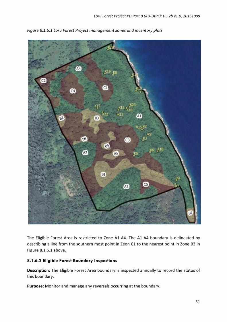
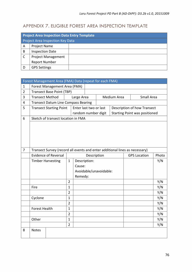
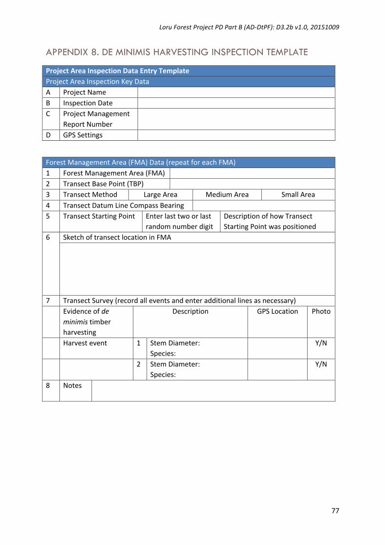
TheEligible ForestArea is restricted to ZoneA1-A4. TheA1-A4boundary is delineatedbydescribingalinefromthesouthernmostpointinZeonC1tothenearestpointinZoneB3inFigure8.1.6.1above.

8.1.6.2 Eligible Forest Boundary Inspections

Description:TheEligibleForestAreaboundaryisinspectedannuallytorecordthestatusofthisboundary.

Purpose:Monitorandmanageanyreversalsoccurringattheboundary.

LoruForestProjectPDPartB(AD-DtPF):D3.2bv1.0,20151009

52

Method:

MakeobservationsoftheEligibleForestAreaboundaryduringthecourseofthe6-monthlyEligibleForestAreaInspections.ThisisconductedduringthewalkingoflinetransectsfromonesideofanEligibleForestAreaboundarytoanother,andbyviewingtheEligibleForestAreaboundaryinbothdirectionsalongtheboundaryfromthepointoneachtransectlineasitmeetstheEligibleForestAreaboundary.IfreversalsattheEligibleForestAreaboundaryareobservedatpointsalongtheboundarythatdonotcoincidewiththelinetransectthenthe reversal is recordedusing theEligibleForestBoundary InspectionTemplate (Appendix6).

Recurrence:6-monthlyinspections.

Responsibility: ProjectOwnerwith supervision support from theProjectCoordinatoruntilsuchtimeasProjectCoordinatorsupervisionsupportnotrequired(asdeterminedbyProjectOwner and Project Coordinator by mutual agreement). Project Coordinator to superviseEligibleForestBoundaryInspectionatleasonceduringeach3-yearlymonitoringperiod.

8.1.6.3 Eligible Forest Area Inspections

Description:DescriptivesurveyofforestconditionwithinEligibleForestAreaboundary.

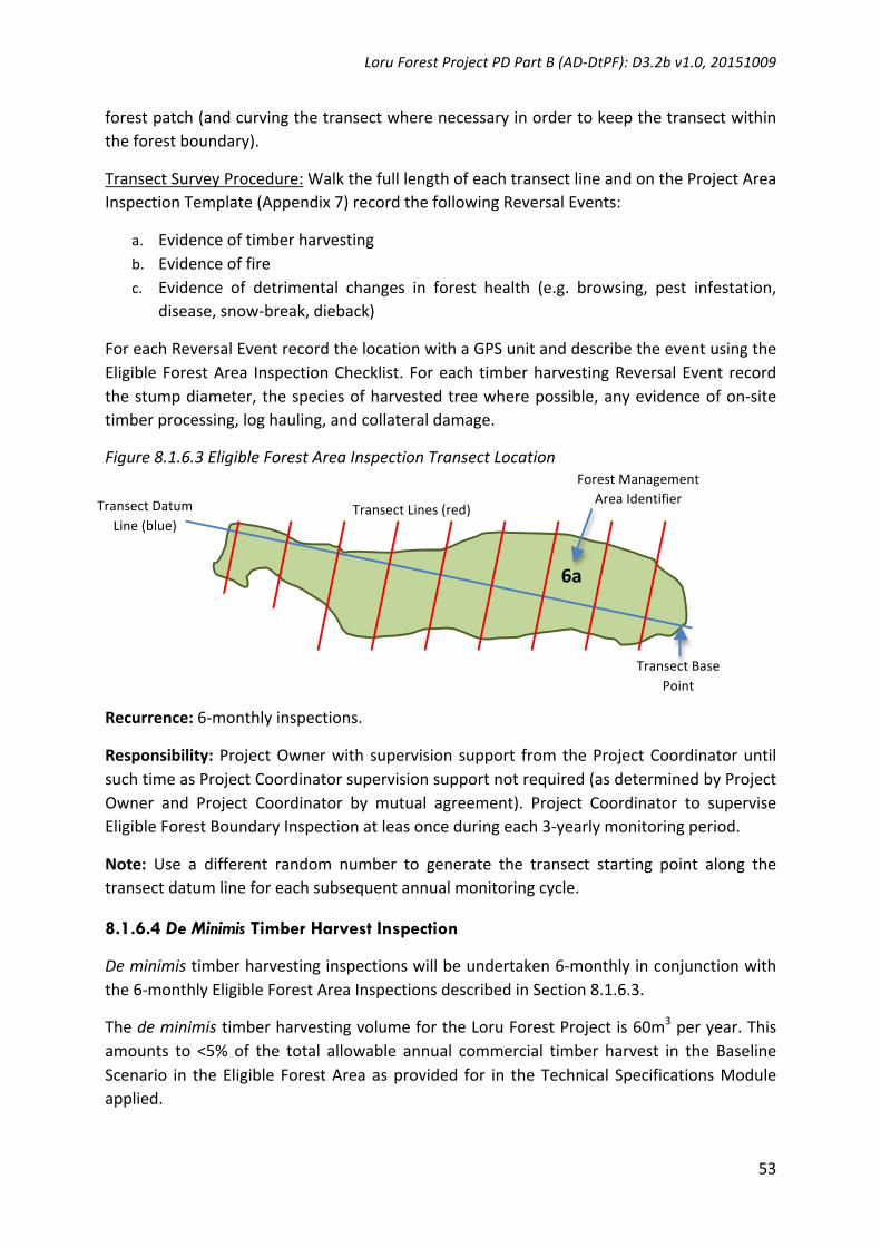
Purpose:Monitor any reversals occurringwithin Eligible ForestArea, andensure that anytimber harvesting lieswithin thedeminimis limit imposedby the Technical SpecificationsModuleapplied.

Method:

Large Area Transect Method: For each Forest Management Area, permanently mark aTransect Base Point with a boundary peg (this can be a boundary peg used for forestinventoryand/orpermanentsampleplots).DefineaTransectDatumLineusingacompassbearingandorient the transectdatum linealong the longaxisof theForestManagementArea (see Figure 8.1.6.3). Use the last two digits from random numbers and convert tometers, to select a transect starting point along the TransectDatum Line.Use a compassbearing to mark out parallel transect lines through the Forest Management Area, withtransects located between 100m and 500m intervals and orientated perpendicular to theTransectDatumLine.

Medium Area Transect Method: For forest management areas that are too small toundertake two or more transects using the Large Area Transect Method, use the samemethodastheLargeAreaTransectMethodbutselectthelastsingledigitfromtherandomnumbersto locatethefirsttransect line,and locatethetransectsbetween20mand100mintervalsalongthetransectdatumline.

SmallAreaTransectMethod:Forforestmanagementareaslessthan100mlong,startwiththeTransectBasePoint,thenlocateasingletransectrunningthroughthelongestaxisofthe

LoruForestProjectPDPartB(AD-DtPF):D3.2bv1.0,20151009

53

forestpatch(andcurvingthetransectwherenecessaryinordertokeepthetransectwithintheforestboundary).

TransectSurveyProcedure:WalkthefulllengthofeachtransectlineandontheProjectAreaInspectionTemplate(Appendix7)recordthefollowingReversalEvents:

a. Evidenceoftimberharvestingb. Evidenceoffirec. Evidence of detrimental changes in forest health (e.g. browsing, pest infestation,

disease,snow-break,dieback)

ForeachReversalEventrecordthelocationwithaGPSunitanddescribetheeventusingtheEligibleForestArea InspectionChecklist.Foreach timberharvestingReversalEvent recordthestumpdiameter,thespeciesofharvestedtreewherepossible,anyevidenceofon-sitetimberprocessing,loghauling,andcollateraldamage.

Figure8.1.6.3EligibleForestAreaInspectionTransectLocation

Recurrence:6-monthlyinspections.

Responsibility: ProjectOwnerwith supervision support from theProjectCoordinatoruntilsuchtimeasProjectCoordinatorsupervisionsupportnotrequired(asdeterminedbyProjectOwner and Project Coordinator by mutual agreement). Project Coordinator to superviseEligibleForestBoundaryInspectionatleasonceduringeach3-yearlymonitoringperiod.

Note: Use a different random number to generate the transect starting point along thetransectdatumlineforeachsubsequentannualmonitoringcycle.

8.1.6.4 De Minimis Timber Harvest Inspection

Deminimistimberharvestinginspectionswillbeundertaken6-monthlyinconjunctionwiththe6-monthlyEligibleForestAreaInspectionsdescribedinSection8.1.6.3.

ThedeminimistimberharvestingvolumefortheLoruForestProjectis60m3peryear.Thisamounts to <5% of the total allowable annual commercial timber harvest in the BaselineScenario in theEligibleForestAreaasprovided for in theTechnical SpecificationsModuleapplied.

TransectBasePoint

TransectDatumLine(blue)

TransectLines(red)

6a

ForestManagementAreaIdentifier

LoruForestProjectPDPartB(AD-DtPF):D3.2bv1.0,20151009

54

Theprojectwillrecorddeminimis timberharvestingeventsusingthetemplatesuppliedinAppendix8.

8.1.6.5 Activity Shifting Leakage Inspection

ActivityShiftingLeakageInspectionswillbeundertakenannually intheLoruForestProjectfollowing firstverification.These inspectionswillbeundertaken inconjunctionwiththe6-monthlyEligibleForestAreaInspectionsdescribedinSection8.1.6.3.

The project will record Activity Shifting Leakage events using the template supplied inAppendix9.

8.1.7 Monitoring Resources and Capacity - Carbon

AccordingtoSection5ofthePlanVivoStandard(2013,p17):

5.9. Amonitoringplanmustbedevelopedforeachprojectinterventionwhichspecifies:5.9.6. Resourcesandcapacityrequired

AccordingtotheTechnicalSpecificationsModule(C)2.1(AD-DtPF):D2.2.1v1.0,20150815:

TheProjectMonitoringPlanmustidentify(andprovideevidencefor)theresourcesavailabletoundertakemonitoring,including:

• Financialresourcesandthesourceofsuchfinance(e.g.unitpricing,grants,fees)• Humanresourcesandcapabilityrequired.

The financialandhuman resourcesallocated toprojectmonitoringarepresented inTable8.1.6above.

8.1.8 Community Monitoring - Carbon

AccordingtoSection5ofthePlanVivoStandard(2013,p17):

5.9. Amonitoringplanmustbedevelopedforeachprojectinterventionwhichspecifies:5.9.7. Howcommunitieswillparticipate inmonitoring,e.g.bytrainingcommunity

membersandgraduallydelegatingmonitoringactivitiesoverthedurationoftheproject

5.9.8. Howresultsofmonitoringwillbesharedanddiscussedwithparticipants

5.10. Whereparticipantsareinvolvedinmonitoring,asystemforcheckingtherobustnessofmonitoringresultsmustbeinplace,e.g.checkingarandomsampleofmonitoringresultsbytheprojectcoordinator.

LoruForestProjectPDPartB(AD-DtPF):D3.2bv1.0,20151009

55

AccordingtotheTechnicalSpecificationsModule(C)2.1(AD-DtPF):D2.2.1v1.0,20150815:

TheProjectMonitoringPlanmustinclude:

• AdescriptionofhowtheProjectOwnerand/orotherlocalpeoplewillparticipateinmonitoringincompliancewiththeProjectParticipationProtocolspecifiedinSection3.1ofthePD(applyingSection3.1oftheNakauMethodologyFramework).

• A description of how the results of monitoring will be shared and discussed withparticipantswithreferencetotheProjectMonitoringWorkshopsspecifiedinSection3.1.7ofthePD(applyingSection3.1.7oftheNakauMethodologyFramework).

• AdescriptionofthequalitycontrolsusedtosafeguardtheintegrityandaccuracyofdatagatheredfrommonitoringactivitiesinvolvingProjectOwnersand/orotherlocalpeople.

CommunityinvolvementinmonitoringissetoutinTable8.1.6above.

8.1.8.1 Community Participation In Monitoring

TheProjectOwnerwillrecruitrangerswithresponsibilitiestoundertakeprojectmonitoringtasks described in Table 8.1.6. Ser-Thiac Ltd (the landowner community business entityresponsibleforthisproject)willberesponsibleforrecruitmentandmanagementofrangersfor this project. The Project Coordinator will provide supervision and support for rangeractivities with this role scaling downwards through time at a rate determined bymutualagreementbetweentheProjectCoordinatorandSer-Thiac.

8.1.8.2 Sharing Results of Community Monitoring

Community monitoring outputs are recorded in annual Project Management ReportspreparedandapprovedbySer-ThiacwiththeassistanceoftheProjectCoordinator.ProjectManagement Reports are submitted for approval to the Project Coordinator and theProgrammeOperator on an annual basis. The Project Coordinator collates the content ofannualProjectManagementReportsintothree-yearlyProjectMonitoringReports.Ser-Thiacand the Project Coordinator approves each Project Monitoring Report before beingsubmitted to the Programme Operator for approval. Once approved by the ProgrammeOperatortheProjectMonitoringReportissubmittedforaverificationaudit.

8.1.8.3 Quality Controls for Community Monitoring

QualitycontrolsforcommunitymonitoringaredescribedinSection8.1.8.2.

8.2 COMMUNITY IMPACT MONITORING

Carbonoffsetsare issuedtothisprojectasaresultof3rdpartyverificationofeachProjectMonitoring Report, which contains data sufficient to provide evidence to support a

LoruForestProjectPDPartB(AD-DtPF):D3.2bv1.0,20151009

56

community impact assertion for the Project Monitoring Period in question. This is arequirementforthecarbonoffsetstobeissuedasPlanVivoCertificatesunderthePlanVivoStandard.

8.2.1 Monitored And Non-Monitored Parameters – Community

Monitoredandnon-monitoredcommunityimpactdataarelistedinTable8.2.1below.

Table8.2.1MonitoredandNon-MonitoredParameters–CommunityImpactsNotation Parameter Unit Origin MonitoredFA Food&Agriculture Various CommunityImpactSurvey Monitored

W Wateraccessibility % CommunityImpactSurvey Monitored

H HouseholdIncome Vatu CommunityImpactSurvey Monitored

P Participation Number&% CommunityImpactSurvey Monitored

8.2.2 Monitored Parameters – Community

Monitoreddataandparametersaresummarizedinthetablesbelow.

DataUnit/Parameter: Food&AgricultureDataunit: VariousDescription: Wewanttoknow:

• Iftheforestproductscontinuetobeusedindicatingthecontinuationoftraditionalpractices

• Ifaccesstolandforgardensdiminishestoapointthatitaffectsaccesstofood

• Ifprojectownersbegintopurchasefoodmoreoftenindicatingincreasedincomebutalsocreatingpossiblenegativeunintendedimpacts(i.e.health)

• Ifincomeisstillsoughtthroughthesaleoffoodandhowthisincomechangesovertime.

Sourceofdata: CommunityImpactSurveyDescriptionofmeasurementmethodsandprocedurestobeapplied:

Structuredinterviewspursuingthefollowingquestions:1.1 Howoftendoyoubuyfood?1.2 Howbigisyourfamilygarden?1.3 Howoftendoyoueatfreefoodfromyourgarden?1.4 Howoftendoyourunoutoffood?1.5 Howoftendoyoueatfoodfromtheforest?1.6Howmuchdoyoumakesellingfood?

Frequencyofmonitoring/recording:

3-yearly

Valuemonitored: VariousMonitoringequipment: SocialsurveyequipmentQA/QCprocedurestobeapplied:

3-yearly3rdpartyverificationofProjectMonitoringReports.

Calculationmethod: Compareresponseswithprevioussurvey

LoruForestProjectPDPartB(AD-DtPF):D3.2bv1.0,20151009

57

DataUnit/Parameter: WaterAccessibilityDataunit: VariousDescription: AccesstowaterhasbeenakeyissueforprojectownersinLoru.Wewantto

knowifimprovedaccesstowaterresultsfromtheproject.Further,accesstowaterbeingsuchabasicneed,isanotherindicatorofoverallwellbeing.Theimpactofthisonwomendeservesspecialattentionbyinterviewers.

Sourceofdata: CommunityImpactSurveyDescriptionofmeasurementmethodsandprocedurestobeapplied:

Structuredinterviewspursuingthefollowingquestions:2.1 Doyourunoutofwater?2.2 Aretheredayswhenyoucanuseasmuchasyoulike?

Frequencyofmonitoring/recording:

3-yearly

Valuemonitored: VariousMonitoringequipment: SocialsurveyequipmentQA/QCprocedurestobeapplied:

3-yearly3rdpartyverificationofProjectMonitoringReports.

Calculationmethod: CompareresponseswithprevioussurveyDataUnit/Parameter: HouseholdIncomeDataunit: VariousDescription: Increasedincomecandemonstrateincreasedwellbeingalthoughitcanalso

bedamaging.Whilewemeasureincomeovertime,wealsomeasurechangesinlivelihoodsortimespentonactivitieseverydaysuchashousework,gardeningetc.Thiswillhelpustoseeifprojectownershavemoretimetogivetonon-coreactivitiesandtherefore,perhapstheirlivesaremadeeasierbytheproject.Wewillalsomonitorifthemoneyiscausingsocialdecayviaitsusefornegativepursuits(i.e.alcohol).Educationisalsousedtodeterminewhetherincreasedincomeiscreatinggreaterwellbeing.

Sourceofdata: CommunityImpactSurveyDescriptionofmeasurementmethodsandprocedurestobeapplied:

Structuredinterviewspursuingthefollowingquestions:3.1 AccesstoEducation3.2 PersonalMonthlyIncome(VUV)3.3 Traveltotown(timesperweek)3.4 Hoursspentcooking(perday)3.5 HoursspentGardening(Perday)3.6 Hoursspentresting

Frequencyofmonitoring/recording:

3-yearly

Valuemonitored: VariousMonitoringequipment: SocialsurveyequipmentQA/QCprocedurestobeapplied:

3-yearly3rdpartyverificationofProjectMonitoringReports.

Calculationmethod: CompareresponseswithprevioussurveyDataUnit/Parameter: ProjectParticipation

LoruForestProjectPDPartB(AD-DtPF):D3.2bv1.0,20151009

58

Dataunit: VariousDescription: Wewanttousethismonitoringasachancetoassesshowwellthe‘REDD+

Enterprise’(i.e.thecooperativeorfamilybusiness)isdoingatengagingtheprojectownersandearninglocaltrust.Thisindicatesresilienceandoverallwellbeingifthefaithinthisinstitutionishigh.

Sourceofdata: CommunityImpactSurveyDescriptionofmeasurementmethodsandprocedurestobeapplied:

Structuredinterviewspursuingthefollowingquestions:4.1HowmanyyouthdoyouknowthatareengagedwiththeREDD+Enterprise?4.2AreyougiventheopportunitytoaccessinformationabouttheREDD+Enterprise'sfinancesandactivities?4.3DoyoutrusttheREDD+Enterprise?

Frequencyofmonitoring/recording:

3-yearly

Valuemonitored: VariousMonitoringequipment: SocialsurveyequipmentQA/QCprocedurestobeapplied:

3-yearly3rdpartyverificationofProjectMonitoringReports.

Calculationmethod: Compareresponseswithprevioussurvey

8.2.3 Monitoring Roles And Responsibilities - Community

Community Impact Monitoring surveys are the responsibility of the Project Coordinator.SurveysaretobeconductedwiththeconsentofSer-Thiac.

8.2.4 Information Management Systems - Community

ThisprojectusestheinformationmanagementsystemdescribedinSection7.1oftheNakauMethodologyFramework.

8.2.5 Simplified Project Monitoring Report Methodology - Community

ThisprojectwillsubmitasimplifiedProjectMonitoringReportforitsfirstverification.

8.2.6 Standard Operating Procedure: Project Monitoring – Community

The StandardOperating Procedure (SOP) forMonitoring Community Impacts is presentedbelow.

Table8.2.6MonitoringSchedule–CommunityImpactsCommunityActivity Frequency Responsibility HumanResources FinancialResourcesFood,consumption,agriculture

3-yearly ProjectCoordinator

ProjectCoordinatorstaff PESunitpriceaccountsforemploymentofProjectCoordinatorstaff

Water 3-yearly Project ProjectCoordinatorstaff PESunitpriceaccountsfor

LoruForestProjectPDPartB(AD-DtPF):D3.2bv1.0,20151009

59

accessibility Coordinator employmentofProjectCoordinatorstaff

Householdincome

3-yearly ProjectCoordinator

ProjectCoordinatorstaff PESunitpriceaccountsforemploymentofProjectCoordinatorstaff

Participation 3-yearly ProjectCoordinator

ProjectCoordinatorstaff PESunitpriceaccountsforemploymentofProjectCoordinatorstaff

8.2.6.1 Baseline Community Impacts

Baseline community impacts were measured during project development and have beenmeasuredandpresentedinSection5.2.2.3oftheLoruForestProjectPDPartAD3.2av1.020151009.

8.2.6.2 Project Community Impacts

Project community impacts will be measured by means of a 3-yearly community impactsurvey to quantify change in the community impact indicators described in Section 8.2.2above.

8.2.6.3 Net Community Impact Enhancements

Tabulation of baseline and project community impacts, and net community impactenhancementswillbepresentedinsummaryusingthefollowingformat.

Baselinecommunity

impacts

Projectcommunity

impacts

Netcommunityimpact

enhancements

Impact1

Impact2…

8.3 BIODIVERSITY MONITORING

Carbonoffsetsare issuedtothisprojectasaresultof3rdpartyverificationofeachProjectMonitoring Report, which contains data sufficient to provide evidence to support abiodiversity impact assertion for the Project Monitoring Period in question. This is arequirementforthecarbonoffsetstobeissuedasPlanVivoCertificatesunderthePlanVivoStandard.

8.3.1 Monitored And Non-Monitored Parameters – Biodiversity

Monitoredandnon-monitoredcommunityimpactdataarelistedinTable8.2.1below.

Table8.3.1MonitoredandNon-MonitoredParameters–BiodiversityImpactsNotation Parameter Unit Origin MonitoredSSA Significantspecies-

AnimalsPresence/absence BiodiversitySurvey Monitored

LoruForestProjectPDPartB(AD-DtPF):D3.2bv1.0,20151009

60

SSP Significantspecies-Plants

Presence/absence BiodiversitySurvey Monitored

8.3.2 Monitored Parameters – Biodiversity

Monitoreddataandparametersaresummarizedinthetablesbelow.

DataUnit/Parameter: SignificantSpecies-AnimalsDataunit: Presence/absenceDescription:

Sourceofdata: BiodiversitySurveyDescriptionofmeasurementmethodsandprocedurestobeapplied:

RecordsignificantspeciesduringEligibleForestAreaInspections.

Frequencyofmonitoring/recording:

3-yearly

Valuemonitored: Presence/absenceMonitoringequipment: Animalidentificationtable,binoculars,mobilephone,itracker

software(orequivalent)QA/QCprocedurestobeapplied:

3-yearly3rdpartyverificationofProjectMonitoringReports.

Calculationmethod: Compareresponseswithprevioussurvey

Monitoreddataandparametersaresummarizedinthetablesbelow.

DataUnit/Parameter: SignificantSpecies-PlantsDataunit: Presence/absenceDescription:

Sourceofdata: BiodiversitySurveyDescriptionofmeasurementmethodsandprocedurestobeapplied:

RecordsignificantspeciesduringEligibleForestAreaInspections.

Frequencyofmonitoring/recording:

3-yearly

Valuemonitored: Presence/absenceMonitoringequipment: Plantidentificationtable,binoculars,mobilephone,itrackersoftware

(orequivalent)QA/QCprocedurestobeapplied:

3-yearly3rdpartyverificationofProjectMonitoringReports.

Calculationmethod: Compareresponseswithprevioussurvey

LoruForestProjectPDPartB(AD-DtPF):D3.2bv1.0,20151009

61

8.3.3 Monitoring Roles And Responsibilities - Biodiversity

BiodiversityMonitoringsurveysaretheresponsibilityoftheProjectOwnerwithsupportandsupervisionoftheProjectCoordinator.SurveysaretobeconductedwiththeconsentofSer-Thiac.

8.3.4 Information Management Systems - Biodiversity

ThisprojectusestheinformationmanagementsystemdescribedinSection7.1oftheNakauMethodologyFramework.

8.3.5 Simplified Project Monitoring Report Methodology - Biodiversity

ThisprojectwillsubmitasimplifiedProjectMonitoringReportforitsfirstverification.

8.3.6 Standard Operating Procedure: Project Monitoring – Biodiversity

TheStandardOperatingProcedure(SOP)forMonitoringBiodiversityispresentedbelow.

Table8.3.6MonitoringSchedule–CommunityImpactsCommunityActivity Frequency Responsibility HumanResources FinancialResourcesBiodiversitySurvey-Animals

3-yearly ProjectOwner ProjectRangers PESunitpriceaccountsforemploymentofProjectCoordinatorstaff

BiodiversitySurvey-Plants

3-yearly ProjectOwner ProjectRangers PESunitpriceaccountsforemploymentofProjectCoordinatorstaff

8.3.6.1 Baseline Biodiversity Impacts

Baselinebiodiversityimpacts(i.e.surveyofareferenceareasupportinghabitattypesinthebaseline)havenotbeenmeasured.AbaselinebiodiversitysurveyisoptionalunderthePlanVivo standardminimum requirements for biodiversity, but it is the aspiration of the LoruForest Project to undertake a baseline biodiversity survey to enable comparison betweenbaselineandprojectbiodiversityindicatorsandgenerateanetbiodiversityimpactassertion.

8.3.6.2 Project Biodiversity Impacts

Project biodiversity impacts will bemeasured bymeans of a 3-yearly biodiversity impactsurvey to quantify change and/or trends in site biodiversity. The first project biodiversityimpact surveywas undertaken during project development and have beenmeasured andpresentedinSection5.3.1oftheLoruForestProjectPDPartAD3.2av1.020151009.

LoruForestProjectPDPartB(AD-DtPF):D3.2bv1.0,20151009

62

8.3.6.3 Net Biodiversity Impact Enhancements

Tabulation of baseline and project biodiversity impacts, and net biodiversity impactenhancementswillbepresentedinsummaryusingthefollowingformat.

Baselinecommunity

impacts

Projectcommunity

impacts

Netcommunityimpact

enhancements

Impact1

Impact2…

LoruForestProjectPDPartB(AD-DtPF):D3.2bv1.0,20151009

63

References BatesDM,WattsDG1980.Relativecurvaturemeasuresofnonlinearity.JournaloftheRoyalStatisticalSociety,

SeriesB:1-25.

CDMToolforDemonstrationandAssessmentofAdditionality.

CDMToolfortestingsignificanceofGHGemissionsinA/RCDMprojectactivities

BasukiTM,vanLaakePE,SkidmoreAK,HussinYA2009.Allometricequationsforestimatingtheabove-groundbiomassintropicallowlandDipterocarpforests.ForestEcologyandManagement257:1684–1694.

Brown S,GilliespieAJR, LugoAE 1989. Biomass estimationmethods for tropical forestswith applications toforestinventorydata.ForestScience35:881–902.

ChaveJ,AndaloC,BrownS,CairnsMA,ChambersJQ,EamusD,FölsterH,FromardF,HiguciN,KiraT,LescureJ-P,NelsonBW,OgawaH,PuigH,RiéraB,YamakuraT2005.Treeallometryandimprovedestimationofcarbonstocksandbalanceintropicalforests.Oecologia145:87–99.

Estrada, M. 2011 Standards and methods available for estimating project-level REDD+ carbon benefits:referenceguideforprojectdevelopers.WorkingPaper52.CIFOR,Bogor,Indonesia.

Enters,T.2001.Trashortreasure?LoggingandmillresiduesinAsiaandthePacific.FAOCorporateDocumentRepository. RAP Publication Version 2001/16, p5. Available here:ftp://ftp.fao.org/docrep/fao/003/x6966e/x6966e00.pdf.

FearnsideP.M.,LashofD.A.,Moura-CostaP.2000.AccountingfortimeinMitigatingGlobalWarmingthroughland-use change and forestry. Mitigation and Adaptation Strategies for Global Change, Volume5,Number3,2000,pp.239-270

GovernmentofFiji2014.FijiReadinessPreparationPlan(R-PP).WorldBankForestCarbonPartnershipFacility.WashingtonDC.Availablehere:https://www.forestcarbonpartnership.org/sites/fcp/files/2014/February/Fiji_R-PP_rev_2014_01_22.pdf

GovernmentofVanuatu2013.VanuatuReadinessPreparationPlan(R-PP).WorldBankForestCarbonPartnershipFacility.WashingtonDC.Availablehere:https://www.forestcarbonpartnership.org/sites/fcp/files/2013/Oct2013/Vanuatu%20R-PP-final_revised%204%20original.pdf

Green Collar 2010. VCS ProposedMethodology for Improved ForestManagement, Conversion of Logged toProtectedForestV3-0,July2010.

HuschB,BeersTW,KershawJA2003.ForestMensuration.4thedn.Wiley,NewJersey.

IPCC2000.Landuse,LanduseChangeandForestry.R.T.Watson,I.R.Noble,B.Bolin,N.H.Ravindranath,D.J.VerardoandD.J.Dokken(Eds.).CambridgeUniversityPress,UK.pp375.Availablehere:http://www.ipcc.ch/ipccreports/sres/land_use/index.php?idp=267#s5-3-4-1

IPCC2003.GoodPracticeGuidanceForLandUse,LandUseChangeAndForestry.IntergovernmentalPanelonClimateChange.Published:IGES,Japan.

LoruForestProjectPDPartB(AD-DtPF):D3.2bv1.0,20151009

64

IPCC 2006. 2006 IPCC Guidelines for National Greenhouse Gas Inventories, Prepared by the NationalGreenhouse Gas Inventories Program, Eggleston H.S., Buendia L.,Miwa K., Ngara T. and Tanabe K.(eds).Published:IGES,Japan.

ISO 14064-2:2006. Greenhouse Gases - Part 2: Specification with guidance at the project level forquantification, monitoring and reporting of greenhouse gas emission reductions or removalenhancements.FirstEdition2006-03-01.

Ketterings QM, Coe R, van Noordwijk M, Ambagau Y, Palm CA 2001. Reducing uncertainty in the use ofallometric biomass equations for predicting above-ground treebiomass inmixed secondary forests.ForestEcologyandManagement146:199–209.

Kilkki,R.1992.Reductionofwoodwastebysmall-scalelogproductionandconversionintropicalhighforest.FAO.ISSN:1014-9945.Availablehere:http://www.fao.org/docrep/u7890E/u7890E00.htm

Moura-Costa, P.H. and C. Wilson, 2000: An equivalence factor between CO2 avoided emissions andsequestration – description and applications in forestry. Mitigation and Adaptation Strategies forGlobalChange5:51-60.

Payton,I.J.,andWeaver,S.A.2011.FijinationalforestcarbonstockassessmentVersion1.CompiledbyCarbonPartnership Ltd for SPC/GIZ Regional Programme Coping with Climate Change in the Pacific IslandRegionandtheFijiForestryDepartment.

Payton,I.J.2012.DevelopmentofanationalmethodologyforforestcarbonstockassessmentinFiji.LandcareResearch. Prepared for Secretariat of the Pacific Community (SPC) / Deutsche Gesellschaft fürInternationale Zusammenarbeit (GIZ) Coping with Climate Change in the Pacific Island RegionProgramme.April2012.

Pinheiro J, BatesD,DebRoy S, SarkarD and R Core Team (2015). nlme: Linear andNonlinearMixed EffectsModels.Rpackageversion3.1-121

ProdanM, Peters R, Cox F, Real P 1997.Mensura forestal. Instituto Interamericano de Cooperación para laAgricultura(IICA),SanJosé,CostaRica.561p.

Rowell,R.1984.Thechemistryofsolidwood.AdvancesinChemistrySeries,207.AmericanChemicalSociety,WashingtonD.C614pp.

ThomasSC1996.Asymptoticheightasapredictorofgrowthandallometriccharacteristics inMalaysianrainforesttrees.AmericanJournalofBotany83:556–566.

UnitedNations1998.KyotoProtocoltotheUnitedNationsFrameworkConventiononClimateChange.

VCS2008.ToolfortheDemonstrationandAssessmentofAdditionalityinVCSAgriculture,ForestryandOtherLandUse (AFOLU) ProjectActivities. ApprovedVCS Tool VT0001.Voluntary Carbon Standard, 2008v1.0.

VCS 2008. Voluntary Carbon Standard Guidance for Agriculture, Forestry and Other Land Use Projects.Availableat:

http://www.v-c-s.org/docs/Guidance%20for%20AFOLU%20Projects.pdf

VCS 2011a. VCS Standard. VCS Version 3 Requirements Document, 8 March 2011, v3.0. Available at:http://www.v-c-s.org/program-documents

VCS 2011b. Verified Carbon Standard AFOLU Non-Permanence Risk Tool. VCS Version 3, ProcurementDocument8March2011,v3.0.

LoruForestProjectPDPartB(AD-DtPF):D3.2bv1.0,20151009

65

Weaver, S.A. Payton, I, Fahey, G. 2012. Rarakau Programme Methodology V1.0. An Improved ForestManagement – Logged to Protected Forest Grouped Project Methodology For New ZealandIndigenous Forest. Rarakau Programme Report D2.1 v1.0, 15 May 2012. Carbon Partnership Ltd.Takaka.

LoruForestProjectPDPartB(AD-DtPF):D3.2bv1.0,20151009

66

Appendices APPENDIX 1: DEFINITIONS

A/R Afforestation/Reforestation

ActivityType Specifically defined carbon project activity combining a reference activity and aprojectactivitytogeneratecarbonbenefits

Afforestation Establishment of forest through planting and/or deliberate seeding on land that,untilthen,wasnotclassifiedasforest(FAO2010).SeeExplanatoryNotebelow.

AFOLU Agriculture,ForestryandOtherLandUses

BaselineScenario

Carbonbalancearisingfrombaseline(BAU)activities

BAU Business-as-Usual

Carbonbalance Sumof carbon in a system into account carbon stored in reservoirs, emissions ofcarbonfromsources,andsequestrationofcarbonintosinks

Carbonbenefits Net CO2e benefits arising from total net avoided emissions and net enhancedremovals

Carbonflux Movementofcarbonthroughdifferentcarbonpools

Carbonpool Componentoftheearthsystemthatstorescarbon

Carbonreservoir

Carbonpoolthatstorescarbonforlongtimescales

Carbonsink Carbonpoolthatabsorbs/sequesterscarbondioxidebytransforminggaseousCO2eintoacarbon-basedliquidorsolid

Carbonsource Carbonpoolthatemitscarbonfromaliquidorsolidformintoagas

CCB ClimateCommunityandBiodiversityStandard

CDM CleanDevelopmentMechanism

CO2e Carbon dioxide equivalent: translation of non-CO2 GHG tonnes into equivalentCO2tonnesthroughconversionusingglobalwarmingpotentialofnon-CO2GHG

ComplianceSpace

What is contained within the GHG accounting boundary of a compliance GHGaccountingregime(e.g.KyotoProtocol,NZETS)

COP ConferenceofParties(totheUNFCCC)

CSR CorporateSocialResponsibility

Deforestation The conversionof forest toother landuseor the long-term reductionof the treecanopy cover below the minimum 10 percent threshold (FAO 2010). SeeExplanatoryNotebelow.

DOE DesignatedOperationalEntity

EligibleArea SubsetofForestAreacomprisingareaofforesteligibleforcrediting

LoruForestProjectPDPartB(AD-DtPF):D3.2bv1.0,20151009

67

Enhancedremovals

Carbon sequestrationassistedbymanagement intervention toa level abovewhatwouldoccurnaturally

Exante Beforetheevent(referringtofutureactivities)

Expost Afterthefact(referringtopastactivities)

ForestArea SubsetofProjectAreacomprisingforestlandwithinProjectArea

ForestDegradation

Thereductionofthecapacityofaforesttoprovidegoodsandservices.

ForestLand Landspanningmorethan0.5hectareswithtreeshigherthan5metersandacanopycover ofmore than 10 percent, or trees able to reach these thresholds in situ. Itdoes not include land that is predominantly under agricultural or urban land use(FAO2010).SeeExplanatoryNotebelow.

GHG GreenhouseGas

GIS GeographicalInformationSystem

GPG GoodPracticeGuidance

HWP HarvestedWoodProducts

IFM ImprovedForestManagement

IFM-LtPF Improvedforestmanagement–loggedtoprotectedforestactivitytype

IPCC IntergovernmentalPanelonClimateChange

ISO InternationalStandardsOrganisation

LULUCF LandUse,LandUseChangeandForestry

MRV Measurement/MonitoringReportingandVerification

Non-ForestLand All land that is not classified as Forest or Other wooded land (FAO 2010). SeeExplanatoryNotesfor‘OtherLand’below).Samedefinitionas‘OtherLand’.

OperationalForestArea

Term used in sustainable forest management plans delimiting area eligible fortimberharvesting

OtherLand All land that is not classified as Forest or Other wooded land (FAO 2010). SeeExplanatoryNotesbelow).Samedefinitionas‘Non-ForestLand’.

OtherWoodedLand

Land not classified as Forest, spanningmore than 0.5 hectares;with trees higherthan 5meters and a canopy cover of 5-10 percent, or trees able to reach thesethresholds insitu;orwithacombinedcoverofshrubs,bushesandtreesabove10percent. Itdoesnot include landthat ispredominantlyunderagriculturalorurbanlanduse(FAO2010).SeeExplanatoryNotebelow.

Participants Theadult land/resource rightsholders involved in theproject– including,butnotlimitedtotheprojectownergroupboard/committeemembers.

PD ProjectDescription

PDD ProjectDesignDocument(synonymouswithPDinthisdocument)

PES PaymentforEcosystemServices

LoruForestProjectPDPartB(AD-DtPF):D3.2bv1.0,20151009

68

ProjectArea Landownershipboundarywithinwhichcarbonprojectwilltakeplace

ProjectCoordinator

TheentityassistingtheProjectOwnertodevelopandimplementtheforestcarbonproject.

ProjectGoverningBoard

Subset of the Project Owner community appointed by the Project OwnercommunitytogoverntheprojectintheinterestsoftheProjectOwnercommunity.

ProjectScenario Carbonbalancearisingfromprojectactivities

ProgrammeOperator

The entity that owns and administers the Nakau Programme. This entity isresponsibleforsafeguardingtheintegrityoftheNakauProgrammeanditsroleistoa)governtheNakauProgramme;b)owntheIPassociatedwithNakauProgrammemethodologiesandprotocols;c)bethebeneficiaryofanycovenantonthelandtitleoftheProjectOwnerthatprotectstheforest;d)ownthebuffercreditsoftheNakauProgramme; e) administer the buffer account with the registry; and f) act as theguardianoftheNakauProgramme.

ProjectOwner Theowneroftheforestandforestcarbonrightssubjecttotheproject

ProjectProponent

TheProjectOwnerandProjectCoordinatorcombined.

ProjectScenario CarbonbalancearisingfromProjectactivities(carbonprojectchangefromBAU)

ProtectedForest

Haltingoravoidingactivitiesthatwouldreducecarbonstocksandmanagingaforesttomaintainhighand/orincreasingcarbonstocks

RED ReducingEmissionsfromDeforestation

REDD ReducingEmissionsfromDeforestationandDegradation

Reforestation Re-establishment of forest through planting and/or deliberate seeding on landclassifiedasforest(FAO2010).SeeExplanatoryNotebelow.

REL ReferenceEmissionLevel:rateofGHGemissionsunderBAU

Removals Carbonsequesteredfromtheatmosphereintoacarbonsink

SFM SustainableForestManagement

UNFCCC UnitedNationsFrameworkConventiononClimateChange

Validation IndependentauditofProjectDescription(PD)and/orMethodology

VCS VerifiedCarbonStandard

Verification IndependentauditofProjectMonitoringReports

LoruForestProjectPDPartB(AD-DtPF):D3.2bv1.0,20151009

69

ExplanatoryNotes

All definitions and explanatory notes relating to forest and non-forest land, afforestation,reforestation, deforestation, forest degradation is taken from the FAO Global ForestResourcesAssessment2010.

Forest Land:

1. Forest is determined both by the presence of trees and the absence of other predominant landuses.Thetreesshouldbeabletoreachaminimumheightof5metersinsitu.

2. Includes areas with young trees that have not yet reached but which are expected to reach acanopy coverof10percentand treeheightof5meters. It also includesareas thatare temporarilyunstockedduetoclear-cuttingaspartofaforestmanagementpracticeornaturaldisasters,andwhichareexpectedtoberegeneratedwithin5years.Localconditionsmay,inexceptionalcases,justifythatalongertimeframeisused.

3. Includes forest roads, firebreaks and other small open areas; forest in national parks, naturereserves and other protected areas such as those of specific environmental, scientific, historical,culturalorspiritualinterest.

4.Includeswindbreaks,shelterbeltsandcorridorsoftreeswithanareaofmorethan0.5hectaresandwidthofmorethan20meters.

5.Includesabandonedshiftingcultivationlandwitharegenerationoftreesthathave,orisexpectedtoreach,acanopycoverof10percentandtreeheightof5meters.

6.Includesareaswithmangrovesintidalzones,regardlesswhetherthisareaisclassifiedaslandareaornot.

7.Includesrubber-wood,corkoakandChristmastreeplantations.

8.Includesareaswithbambooandpalmsprovidedthatlanduse,heightandcanopycovercriteriaaremet.

9. Excludes tree stands in agricultural production systems, such as fruit tree plantations, oil palmplantations and agroforestry systems when crops are grown under tree cover. Note: Someagroforestrysystemssuchasthe“Taungya”systemwherecropsaregrownonlyduringthefirstyearsoftheforestrotationshouldbeclassifiedasforest.

Other Wooded Land

1.Thedefinitionabovehastwooptions:

• Thecanopycoveroftreesisbetween5and10percent;treesshouldbehigherthan5metersorabletoreach5metersinsitu.

• Thecanopycoverof trees is less than5percentbut thecombinedcoverof shrubs,bushesandtrees ismorethan10percent. Includesareasofshrubsandbusheswherenotreesarepresent.

2.Includesareaswithtreesthatwillnotreachaheightof5metersinsituandwithacanopycoverof10percentormore,e.g.somealpinetreevegetationtypes,aridzonemangroves,etc.

3.Includesareaswithbambooandpalmsprovidedthatlanduse,heightandcanopycovercriteriaaremet.

LoruForestProjectPDPartB(AD-DtPF):D3.2bv1.0,20151009

70

Other Land

1. Includes agricultural land, meadows and pastures, built-up areas, barren land, land underpermanentice,etc.

2.Includesallareasclassifiedunderthesub-category“Otherlandwithtreecover”.

Afforestation

1.Impliesatransformationoflandusefromnon-foresttoforest.

Reforestation

1.Impliesnochangeoflanduse.

2.Includesplanting/seedingoftemporarilyunstockedforestareasaswellasplanting/seedingofareaswithforestcover.

3.Includescoppicefromtreesthatwereoriginallyplantedorseeded.

4.Excludesnaturalregenerationofforest.

Deforestation

1.Deforestation impliesthe long-termorpermanent lossofforestcoverand impliestransformationintoanotherlanduse.Suchalosscanonlybecausedandmaintainedbyacontinuedhuman-inducedornaturalperturbation.

2.Deforestationincludesareasofforestconvertedtoagriculture,pasture,waterreservoirsandurbanareas.

3.Thetermspecificallyexcludesareaswherethetreeshavebeenremovedasaresultofharvestingorlogging, and where the forest is expected to regenerate naturally or with the aid of silviculturalmeasures. Unless logging is followed by the clearing of the remaining logged-over forest for theintroduction of alternative land uses, or the maintenance of the clearings through continueddisturbance,forestscommonlyregenerate,althoughoftentoadifferent,secondarycondition.

4. In areas of shifting agriculture, forest, forest fallow and agricultural lands appear in a dynamicpatternwheredeforestation and the returnof forest occur frequently in small patches. To simplifyreportingofsuchareas,thenetchangeoveralargerareaistypicallyused.

5.Deforestationalsoincludesareaswhere,forexample,theimpactofdisturbance,overutilizationorchangingenvironmentalconditionsaffectstheforesttoanextentthat itcannotsustainatreecoverabovethe10percentthreshold.

LoruForestProjectPDPartB(AD-DtPF):D3.2bv1.0,20151009

71

APPENDIX 2. SITE DESCRIPTION PLOT SHEET

SITEDESCRIPTIONPLOTSHEET

Surveyname: Datemeasured:

Plotidentifier: Measuredby:

Location:

Plotlayout: GPSmake&model

Bearing Slopedistance Slopeangle Easting:

A–B Southing:

B–C Single/averaged2D/3D±m

C–D Datum:

D–A

Altitude(m)

Physiography:ridgegullyfaceterrace

Aspect(0-359°)

Slope(°)concaveconvexlinear

Averagetopheight(m)

CanopyCover(%)

Cultural:noneburntloggedcleared

minedgrazedtracked

Subplotsoutsidesurveyarea:

Locationdiagram:

Approachnotes:

Dominanttreespecies:

Otherplantspecies:

Fauna: Notes:

LoruForestProjectPDPartB(AD-DtPF):D3.2bv1.0,20151009

72

APPENDIX 3. FOLIAR COVER SCALE

LoruForestProjectPDPartB(AD-DtPF):D3.2bv1.0,20151009

73

APPENDIX 4. STEM DIAMETER RECORD SHEET

PlotIdentifier: Measuredby:Date: Recordedby:

Subplot TagNo. Localname Botanicalname Diameter Notes

LoruForestProjectPDPartB(AD-DtPF):D3.2bv1.0,20151009

74

APPENDIX 5. LORU CARBON BUDGET & PRICING SPREADSHEET

Suppliedseparately

LoruForestProjectPDPartB(AD-DtPF):D3.2bv1.0,20151009

75

APPENDIX 6. ELIGIBLE FOREST BOUNDARY INSPECTION TEMPLATE

ProjectBoundaryInspectionDataEntryTemplateProjectBoundaryInspectionKeyDataA ProjectName B InspectionDate C ProjectManagement

ReportNumber

D GPSSettings

ForestManagementArea(FMA)Data(repeatforeachFMA)1 ForestManagementArea(FMA) 2 TransectBasePoint(TBP)

Selectupto4landmarksidentifiablebyaerialimageryasanchorpointslinkinggroundbaseddatawithaerialimagerydata

KeyIdentifiers

Name/Description GPSLocationKeyIdentifier1 E.g.RoadIntersectionwithfenceline

20mSWofTBP

KeyIdentifier2 KeyIdentifier3

3

KeyIdentifier4 4 EligibleForestAreaBoundary(GPSReadings@50mintervals) GPSFilenumber BoundarySurvey(recordalleventsandenteradditionallinesasnecessary)5 EvidenceofReversal Description GPSLocation Photo TimberHarvesting 1 Description:

Cause:Avoidable/unavoidable:Remedy:

Y/N

2 Y/N Fire 1 Y/N 2 Y/N ForestHealth 1 Y/N 2 Y/N6 EvidenceofAddition Description GPSLocation Photo 1 Y/N 2 Y/N7 Notes

LoruForestProjectPDPartB(AD-DtPF):D3.2bv1.0,20151009

76

APPENDIX 7. ELIGIBLE FOREST AREA INSPECTION TEMPLATE

ProjectAreaInspectionDataEntryTemplateProjectAreaInspectionKeyDataA ProjectName B InspectionDate C ProjectManagement

ReportNumber

D GPSSettings

ForestManagementArea(FMA)Data(repeatforeachFMA)1 ForestManagementArea(FMA) 2 TransectBasePoint(TBP) 3 TransectMethod LargeArea MediumArea SmallArea4 TransectDatumLineCompassBearing 5 TransectStartingPoint Enterlasttwoorlast

randomnumberdigitDescriptionofhowTransectStartingPointwaspositioned

SketchoftransectlocationinFMA6

7 TransectSurvey(recordalleventsandenteradditionallinesasnecessary) EvidenceofReversal Description GPSLocation Photo TimberHarvesting 1 Description:

Cause:Avoidable/unavoidable:Remedy:

Y/N

2 Y/N Fire 1 Y/N 2 Y/N Cyclone 1 Y/N 2 Y/N ForestHealth 1 Y/N 2 Y/N Other 1 Y/N 2 Y/N8 Notes

LoruForestProjectPDPartB(AD-DtPF):D3.2bv1.0,20151009

77

APPENDIX 8. DE MINIMIS HARVESTING INSPECTION TEMPLATE

ProjectAreaInspectionDataEntryTemplateProjectAreaInspectionKeyDataA ProjectName B InspectionDate C ProjectManagement

ReportNumber

D GPSSettings

ForestManagementArea(FMA)Data(repeatforeachFMA)1 ForestManagementArea(FMA) 2 TransectBasePoint(TBP) 3 TransectMethod LargeArea MediumArea SmallArea4 TransectDatumLineCompassBearing 5 TransectStartingPoint Enterlasttwoorlast

randomnumberdigitDescriptionofhowTransectStartingPointwaspositioned

SketchoftransectlocationinFMA6

7 TransectSurvey(recordalleventsandenteradditionallinesasnecessary) Evidenceofde

minimistimberharvesting

Description GPSLocation Photo

Harvestevent 1 StemDiameter:Species:

Y/N

2 StemDiameter:Species:

Y/N

8 Notes

LoruForestProjectPDPartB(AD-DtPF):D3.2bv1.0,20151009

78

APPENDIX 9. ACTIVITY SHIFTING INSPECTION TEMPLATE

ProjectAreaInspectionDataEntryTemplateProjectAreaInspectionKeyDataA ProjectName B InspectionDate C ProjectManagement

ReportNumber

D GPSSettings

ForestManagementArea(FMA)Data(repeatforeachFMA)1 ForestManagementArea(FMA) 2 TransectBasePoint(TBP) 3 TransectMethod LargeArea MediumArea SmallArea4 TransectDatumLineCompassBearing 5 TransectStartingPoint Enterlasttwoorlast

randomnumberdigitDescriptionofhowTransectStartingPointwaspositioned

SketchoftransectlocationinFMA6

7 TransectSurvey(recordalleventsandenteradditionallinesasnecessary) Evidence of Activity

ShiftingDescription GPSLocation Photo

Harvestevent 1 Areaaffected(ha):

Y/N

2 Areaaffected(ha):

Y/N

8 Notes

LoruForestProjectPDPartB(AD-DtPF):D3.2bv1.0,20151009

79

APPENDIX 10. ADDITIONALITY ASSESSMENT

ThisprojectappliesthemostrecentVCStoolforthedemonstrationofadditionality:

“Tool for the demonstration and assessment of additionality in VCS agriculture,forestryandotherlanduse(AFOLU)projectactivities,VT0001,v3.0”

PROCEDURE

Projectproponent(s)shallapplythefollowingfoursteps:

(a) STEP1.IdentificationofalternativelandusescenariostotheAFOLUprojectactivity;

(b) STEP2. Investment analysis todetermine that theproposedproject activity is notthemosteconomicallyorfinanciallyattractiveoftheidentifiedlandusescenarios;or

(c) STEP3.Barriersanalysis;and

(d) STEP4.Commonpracticeanalysis.

STEP 1: IDENTIFICATION OF ALTERNATIVE LAND USE SCENARIOS

Sub-step 1a. Identify credible alternative land use scenarios

TheVCSAFOLUAdditionalityToolrequiresprojectstoundertakethefollowing:

(a) Identifyrealisticandcredibleland-usescenariosthatwouldhaveoccurredonthelandwithintheproposed project boundary in the absence of the AFOLU project activity under the VCS. Thescenarios should be feasible for the project area taking into account relevant national and/orsectoralpoliciesandcircumstances,suchashistorical landuses,practicesandeconomictrends.Theidentifiedlandusescenariosshallatleastinclude:

i. Continuationofthepre-projectlanduse;

ii. Project activity on the land within the project boundary performed without beingregisteredastheVCSAFOLUproject;

iii. Ifapplicable,activitiessimilartotheproposedprojectactivityonatleastpartofthelandwithintheprojectboundaryoftheproposedVCSAFOLUprojectatarateresultingfrom:

• Legalrequirements;or

• Extrapolation of observed similar activities in the geographical area with similarsocio-economicandecologicalconditionstotheproposedVCSAFOLUprojectactivityoccurringintheperiodbeginningtenyearspriortotheprojectstartdate.

Realisticandcredible landuse scenarios thatwouldhaveoccurredon the landwithin theEligibleForestAreaintheabsenceofthisprojectinclude:

LoruForestProjectPDPartB(AD-DtPF):D3.2bv1.0,20151009

80

• Copraproduction• Cattlegrazing• Cashcropgardening• Landclearanceandincreasenon-forestland• Protectionofforestbutwithoutanymonetarybenefits(butgainotherbenefitssuch

ashoneybees,tourism)• Harvestingshort-rotationenergycrop• Sustainableharvestingresourcesforindustrialgoodsandpackaging(pulpandpaper,

particleboard)• Continueloggingasasourceofincome.

These landusesare consistentwith localdevelopmentand landuse trends,evidencedbylanduseactivitiesonneighbouringlandsandthroughoutlowlandeasternSanto.

TheVCSAFOLUAdditionalityToolrequiresprojectstoundertakethefollowing:

(b) All identified land use scenarios must be credible. All land-uses within the boundary of theproposedVCSAFOLUprojectthatarecurrentlyexistingorthatexistedatsometimeintheperiodbeginningtenyearsprior totheprojectstartdatebutno longerexist,maybedeemedrealisticandcredible.Forallother landusescenarios,credibilityshallbe justified.The justificationshallinclude elements of spatial planning information (if applicable) or legal requirements andmayincludeassessmentofeconomicalfeasibilityoftheproposedlandusescenario.

Credibilityassessmentofalternativelandusescenarios:

CredibilityAssessmentofAlternativeLandUseScenariosLandusescenario CredibleY/N ExplanationCopraproduction Y Thisisapredominantlandusetypeforthis

partofVanuatu,andsuchlanduseexistsonneighbouringlands,alongwithsupportingmarketsandinfrastructure

Cattlegrazing Y ThisisapredominantlandusetypeforthispartofVanuatu,andsuchlanduseexistsonneighbouringlands,alongwithsupportingmarketsandinfrastructure

Cashcropgardeningonclearedland Y ThisisapredominantlandusetypeforthispartofVanuatu,andsuchlanduseexistsonneighbouringlands,alongwithsupportingmarketsandinfrastructure

Protectionofforestbutwithoutanymonetarybenefit(butgainotherbenefitssuchashoney,tourism)

N TourismwasattemptedatLorubutdidnotgenerateincomesufficienttoaddressconservationopportunitycosts.SuccessfultourismalsorequiresaskillsetthatisbeyondthecapacityoftheLorulandowners.Furthermore,thevalueofthetouristattractionatLorucannotcompetewithothertourismattractionsinthevicinitysuch

LoruForestProjectPDPartB(AD-DtPF):D3.2bv1.0,20151009

81

asdivingonWWIIshipwreck,andbathingatChampaignbeach.Atbesttourismcouldfunctionasacomplementarymeasuretootherlandusescapableofmeetingthecoreeconomicdevelopmentneedsofthelandownercommunity.Honeyproductionispotentiallycrediblelandusebutwouldbeinsufficientinfinancialscaletoaddressconservationopportunitycosts,andcannotcompetewitheconomicbenefitsfromdeforestation(timberrevenue),copraproductionandcattlegrazingforwhichthereisamplesupportinginfrastructureandmarkets.Aswithtourism,honeyproductioncould(atbest)functionasacomplementarymeasuretootherlandusescapableofmeetingthecoreeconomicdevelopmentneedsofthelandownercommunity.

Harvestingshortrotationenergycrop N Nomarketorinfrastructureexiststosupportgrowingandharvestingofshortrotationenergycrops.

Sustainablyharvestingresourcesforindustrialgoods(e.g.pulppaper,particleboard)

N Noinfrastructureexiststosupportsustainableharvestingofindustrialforestproducts.AlsotheLorulandareaisinsufficienttogenerateaneconomyofscalesufficienttoprovideforviabilityofsustainableharvestsofindustrialgoods.

TheVCSAFOLUAdditionalityToolrequiresprojectstoundertakethefollowing:

(c) OutcomeofSub-step1a:ListofcrediblealternativelandusescenariosthatcouldhaveoccurredonthelandwithintheprojectboundaryoftheVCSAFOLUproject.

• Copraproduction• Cattlegrazing• Cashcropgardening

LoruForestProjectPDPartB(AD-DtPF):D3.2bv1.0,20151009

82

Sub-step 1b. Consistency of credible land use scenarios with laws and regulations

TheVCSAFOLUAdditionalityToolrequiresprojectstoundertakethefollowing:

(a) Applythefollowingprocedure:i. Demonstratethatall landusescenarios identified inthesub-step1a:are incompliance

withallmandatoryapplicablelegalandregulatoryrequirements;ii. If an alternative does not comply with all mandatory applicable legislation and

regulationsthenshowthat,basedonanexaminationofcurrentpracticeintheregioninwhich the mandatory law or regulation applies, those applicable mandatory legal orregulatory requirements are systematically not enforced and that non-compliancewiththose requirements is widespread, i.e., prevalent on at least 30% of the area of thesmallestadministrativeunitthatencompassestheprojectarea;

iii. Removefromthelandusescenariosidentifiedinthesub-step1a,anylandusescenarioswhich are not in compliancewith applicablemandatory laws and regulations unless itcan be shown these land use scenarios result from systematic lack of enforcement ofapplicablelawsandregulations.

NB: This sub-stepdoesnot consider laws, statutes, regulatory frameworksor policies implementedsince11November2001thatgivecomparativeadvantagetolessemissions-intensivetechnologiesoractivitiesrelativetomoreemissions-intensivetechnologiesoractivities.

Thisprojectasserts that thebaselineactivity is that theSerakarClan change the landusefrom forest to non-forest land use. This involves harvesting timber from deforestationactivityandusing revenue fromtimber to finance the forest removaland toprovide seedcapitalforagriculturaldevelopmentontheclearedlands.Agriculturaldevelopmentinvolvesconversionofthelandtocopra,cashcroppingandcattlegrazing.TheSerakarClanwoulddothis themselves following the way they have converted land historically. No third partydevelopstheland.

The Constitution of Vanuatu assigns the ownership of land and resources to customlandowners (discussed in PIN). Landowners therefore, do not need to seek permission toharvest their own timber or to convert land to agricultural production. No licenses arerequiredifitisthelandownerthemselvesmakingthechangesinlanduseontheirownland.

ThereisnoofficialplanningframeworkinforceontheislandofSanto,andassuch,therearenolegalorplanningconstraintsonlandownerstoundertakelanddevelopmentactivitiesontheirownlands.

Thebaselineactivitydoesnot involvetheapplicationofany leasearrangement for timberextraction or agriculture because under the baseline the Serakar Clan would undertaketheseactivities themselves–withno lease requirement.As such, there isnoactivationofconditions under the Land Leases Act. Any timber harvesting leases and licenses in thebaselinewouldgothroughtheForestryAct.Part4oftheForestryAct(CAP276)describestheprocessrequiredforcustomlandownersshouldtheywantacommercial leaseontheirland for timber harvesting. But this would only be relevant where a third party were

LoruForestProjectPDPartB(AD-DtPF):D3.2bv1.0,20151009

83

undertakingtheloggingundera leasearrangement.NothinginthissectionoftheForestryActinhibitstheSerakarClanfrompursuingtimberharvestingthemselves.

Part 5 of the Forestry Act (CAP 276) outlines procedures for licenses to harvest or millsandalwood (5 years up to 500cubicmetres). Again this legislation does not impede theSerakarClanfrompursuingsandalwoodharvesting.

Section6oftheForestryAct(CAP276)statesthat iftheMinister’sopiniontheforestareahas particular scientific, cultural or social significance s/he can declare it a ‘ConservationArea.’However,Clause52ofthesameActstatesthatthecustomownerscancancelthisatanytimeinwritingtotheMinister.

Thereis,asyet,nolegislationforAgriculturalactivity.In2015anAgricultureBillwasdraftedplacingcopraasoneof thekeyproducts forVanuatu topromotebut thisbill is yet tobeenacted.

The Government of Vanuatu Agriculture Policy promotes copra as a major agriculturalproductforthecountryandthegovernmentstronglysupportscopraproduction.

TheVCSAFOLUAdditionalityToolrequiresprojectstoundertakethefollowing:

(b) OutcomeofSub-step1b:ListofplausiblealternativelandusescenariostotheVCSAFOLUprojectactivity that are in compliancewithmandatory legislation and regulations taking into accounttheirenforcement intheregionorcountryandEBdecisionsonnationaland/orsectoralpoliciesandregulations.IfthelistresultingfromtheSub-step1bisemptyorcontainsonlyonelandusescenario,thantheproposedVCSAFOLUprojectactivityisnotadditional.

List of plausible alternative land use scenarios that are in compliance with mandatorylegislationandregulationstakingintoaccounttheirenforcementinVanuatu:

• Copraproduction• Cattlegrazing• Cashcropgardening

Sub-step 1c. Selection of the baseline scenario:

AccordingtotheVCSAFOLUAdditionalityTool:

Thebaselinemethodology thatwoulduse this tool shall provide fora stepwiseapproach justifyingtheselectionanddeterminationofthemostplausiblebaselinescenario.

→ProceedtoStep2(Investmentanalysis)orStep3(Barrieranalysis),asitisnecessarytoundertakeatleastoneofthem.

This project elects to undertake a Barrier Analysis and thereby moves directly to Step 3below.

LoruForestProjectPDPartB(AD-DtPF):D3.2bv1.0,20151009

84

STEP 2. INVESTMENT ANALYSIS

TheVCSAFOLUAdditionalityToolrequiresprojectsto:

Determinewhethertheproposedprojectactivity,withouttherevenuefromthesaleofGHGcreditsiseconomically or financially less attractive than at least one of the other land use scenarios.Investmentanalysismaybeperformedasastand-aloneadditionalityanalysisorinconnectiontotheBarrieranalysis(Step3).Toconducttheinvestmentanalysis,usethefollowingsub-steps.

Sub-step 2a. Determine appropriate analysis method

TheVCSAFOLUAdditionalityToolrequiresprojectsto:

Determine whether to apply simple cost analysis, investment comparison analysis or benchmarkanalysis (sub-step 2b). If theVCSAFOLUproject generates no financial or economic benefits otherthan VCS related income, then apply the simple cost analysis (Option I). Otherwise, use theinvestmentcomparisonanalysis(OptionII)orthebenchmarkanalysis(OptionIII).Note,thatOptionsI,IIandIIIaremutuallyexclusivehence,onlyoneofthemcanbeapplied.

Sub-step 2b. – Option I. Apply simple cost analysis

TheVCSAFOLUAdditionalityToolrequiresprojectsto:

Document the costs associated with the VCS AFOLU project and demonstrate that the activityproducesnofinancialbenefitsotherthanVCSrelatedincome.

→If it isconcludedthattheproposedVCSAFOLUprojectproducesnofinancialbenefitsotherthanVCSrelatedincomethenproceedtoStep4(Commonpracticeanalysis).

Sub-step 2b. – Option II. Apply investment comparison analysis

TheVCSAFOLUAdditionalityToolrequiresprojectsto:

Identify the financial indicator, such as IRR (investment rate of return), NPV (net present value),paybackperiod,costbenefitratiomostsuitablefortheprojecttypeanddecision-makingcontext.

Sub-step 2b – Option III. Apply benchmark analysis

TheVCSAFOLUAdditionalityToolrequiresprojectsto:

Identify the financial indicator, such as IRR, NPV, payback period, cost benefit ratio, or other (e.g.requiredrateofreturn(RRR)relatedto investments inagricultureor forestry,bankdeposit interestratecorrectedforriskinherenttotheprojectortheopportunitycostsofland,suchasanyexpectedincome from land speculation)most suitable for theproject typeanddecision context. Identify therelevantbenchmarkvalue,suchastherequiredrateofreturn(RRR)onequity.Thebenchmarkistorepresent standard returns in themarket, considering the specific risk of the project type, but notlinked to the subjective profitability expectation or risk profile of a particular project developer.Benchmarkscanbederivedfrom:

LoruForestProjectPDPartB(AD-DtPF):D3.2bv1.0,20151009

85

(a) Governmentbond rates, increasedbya suitable riskpremium to reflectprivate investmentand/ortheprojecttype,assubstantiatedbyanindependent(financial)expert;

(b) Estimates of the cost of financing and required return on capital (e.g., commercial lendingrates and guarantees required for the country and the type of project activity concerned),basedonbankersviewsandprivateequity investors/funds‟ requiredreturnoncomparableprojects;

(c) A company internal benchmark (weighted average capital cost of the company) if there isonly one potential project developer (e.g., when the proposed project land is owned orotherwisecontrolledbyasingleentity,physicalpersonoracompany,whoisalsotheprojectdeveloper). The project developers shall demonstrate that this benchmark has beenconsistentlyusedinthepast,i.e.,thatprojectactivitiesundersimilarconditionsdevelopedbythesamecompanyusedthesamebenchmark.

Sub-step 2c. Calculation and comparison of financial indicators

AccordingtotheVCSAFOLUAdditionalityToolthoseprojectselectingOptionsIIandIIIarerequiredtocalculateandcomparefinancialindicatorsasfollows:

(a) Calculate the suitable financial indicator for the proposed VCS AFOLU project without thefinancial benefits from the VCS and, in the case ofOption II above, for the other land usescenarios. Include all relevant costs (including, for example, the investment cost, theoperations and maintenance costs), and revenues (excluding GHG credit revenues, butincludingsubsidies/fiscal incentiveswhereapplicable),and,asappropriate,non-marketcostandbenefitsinthecaseofpublicinvestors.

(b) Present the investment analysis in a transparent manner and provide all the relevantassumptions in the VCS AFOLU project description, so that a reader can reproduce theanalysis and obtain the same results. Clearly present critical economic parameters andassumptions (such as capital costs, lifetimes, and discount rate or cost of capital). Justifyand/or cite assumptions in a manner that can be validated. In calculating the financialindicator,theproject’sriskscanbeincludedthroughthecashflowpattern,subjecttoproject-specific expectations and assumptions (e.g. insurance premiums can be used in thecalculationtoreflectspecificriskequivalents).

(c) Assumptions and input data for the investment analysis shall not differ across the projectactivityanditsalternatives,unlessdifferencescanbewellsubstantiated.

(d) PresentintheVCSAFOLUprojectdescriptionsubmittedforvalidationaclearcomparisonofthefinancialindicatorfortheproposedVCSAFOLUprojectwithoutthefinancialbenefitsfromtheVCSand:

i. OptionII(investmentcomparisonanalysis):Ifoneoftheotherlandusescenarioshasthe better indicator (e.g. higher IRR), then the VCS AFOLU project cannot beconsideredasthefinanciallyattractive;or

ii. Option III (benchmark analysis): If the VCS AFOLU project has a less favorableindicator(e.g.,lowerIRR)thanthebenchmark,thentheVCSAFOLUprojectcannotbeconsideredasfinanciallyattractive.

→IfitisconcludedthattheproposedVCSAFOLUprojectwithoutthefinancialbenefitsfromtheVCSisnotfinanciallymostattractivethenproceedtoStep2d(SensitivityAnalysis).

LoruForestProjectPDPartB(AD-DtPF):D3.2bv1.0,20151009

86

Sub-step 2d. Sensitivity analysis

AccordingtotheVCSAFOLUAdditionalityToolthoseprojectselectingOptionsIIandIIIarerequiredtoundertakeasensitivityanalysisasfollows:

Include a sensitivity analysis that shows whether the conclusion regarding the financialattractivenessisrobusttoreasonablevariationsinthecriticalassumptions.Theinvestmentanalysisprovides a valid argument in favour of additionality only if it consistently supports (for a realisticrange of assumptions) the conclusion that the proposed VCS AFOLU project without the financialbenefitsfromtheVCSisunlikelytobefinanciallyattractive.

(a) Ifafter thesensitivityanalysis it isconcludedthattheproposedVCSAFOLUprojectwithoutthefinancialbenefitsfromtheVCSisunlikelytobefinanciallymostattractive(OptionIIandOptionIII),thenproceeddirectlytoStep4(Commonpracticeanalysis).

(b) IfafterthesensitivityanalysisitisconcludedthattheproposedVCSAFOLUprojectislikelytobe financiallymost attractive (Option II andOption III), then the project activity cannot beconsidered additional bymeans of financial analysis. Optionally proceed to Step 3 (Barrieranalysis) to prove that the proposedproject activity faces barriers that do not prevent thebaseline landusescenario(s)fromoccurring. IftheStep3(Barrieranalysis) isnotemployedthentheprojectactivitycannotbeconsideredadditional.

STEP 3. BARRIER ANALYSIS

According to the VCS AFOLU Additionality Tool projects can elect to undertake a barrier analysisinsteadoforasanextensionofinvestmentanalysis:

Ifthisstepisused,determinewhethertheproposedprojectactivityfacesbarriersthat:

(a) Prevent the implementation of this type of proposed project activity without the revenuefromthesaleofGHGcredits;and

(b) Donotpreventtheimplantationofatleastoneofthealternativelandusescenarios.

Themostplausiblebaseline scenario for thisproject isa combinationof copraproductioncattlegrazingandcashcropgardeningfollowingthedeforestationoftheforestinquestion.Thiswould be combinedwith the retention of a small percentage of indigenous forest inareasnotsuitabletotheseagriculturalactivitiesduetosteepnessoflandandthelikelihoodofsmallpatchesofremnantforestinareasnotuseddirectlyforagriculture.Anexampleofthispatternofforest/non-forestlandusecanbeseenintheareaimmediatelysurroundingtheProjectArea(seeFigure2.4.3oftheLoruPDPartAD3.2av1.020151009).

LoruForestProjectPDPartB(AD-DtPF):D3.2bv1.0,20151009

87

Sub-step 3a. Barriers that would prevent the proposed project activity

WhenundertakingaBarrierAnalysistheVCSAFOLUAdditionalityToolrequiresprojectsto:

(a) Establishthattherearebarriersthatwouldpreventtheimplementationofthetypeofproposedprojectactivityfrombeingcarriedout iftheprojectactivitywasnotregisteredasaVCSAFOLUproject. The barriers should not be specific to the project or the project proponent(s). Suchbarriersmayinclude,amongothers:

(b) Investmentbarriers,otherthantheeconomic/financialbarriersinStep2above,interalia:i. For AFOLU project activities undertaken and operated by private entities: Similar

activities have only been implemented with grants or other non-commercial financeterms.Inthiscontextsimilaractivitiesaredefinedasactivitiesofasimilarscalethattakeplace in a comparable environment with respect to regulatory framework and areundertakenintherelevantgeographicalarea;

ii. Debtfundingisnotavailableforthistypeofprojectactivity;iii. Noaccesstointernationalcapitalmarketsduetorealorperceivedrisksassociatedwith

domestic or foreigndirect investment in the countrywhere theproject activity is tobeimplemented, as demonstrated by the credit rating of the country or other countryinvestmentreportsofreputedorigin;

iv. Lackofaccesstocredit.

(c) Institutionalbarriers,interalia:i. Riskrelatedtochangesingovernmentpoliciesorlaws;ii. Lackofenforcementofforestorland-use-relatedlegislation.

(d) Technologicalbarriers,interalia:

i. Lackofaccesstoplantingmaterials;ii. Lackofequipmentand/orinfrastructureforimplementationofthetechnology.

(e) Barriersrelatedtolocaltradition,interalia:i. Traditionalknowledgeorlackthereof,lawsandcustoms,marketconditions,practices;ii. Traditionalequipmentandtechnology.

(f) Barriersduetoprevailingpractice,interalia:i. The project activity is the “first of its kind”:No project activity of this type is currently

operationalinthehostcountryorregion.

(g) Barriersduetolocalecologicalconditions,interalia:i. Degradedsoil(e.g.water/winderosion,salination,etc.);ii. Catastrophicnaturaland/orhuman-inducedevents(e.g.landslides,fire,etc);iii. Unfavorablemeteorologicalconditions(e.g.early/latefrost,drought);iv. Pervasiveopportunisticspeciespreventingregenerationoftrees(e.g.grasses,weeds);v. Unfavorablecourseofecologicalsuccession;vi. Bioticpressureintermsofgrazing,foddercollection,etc.

(h) Barriersduetosocialconditionsandland-usepractices,interalia:

i. Demographicpressureontheland(e.g.increaseddemandonlandduetopopulationii. growth);iii. Socialconflictamonginterestgroupsintheregionwheretheprojecttakesplace;iv. Widespreadillegalpractices(e.g.illegalgrazing,non-timberproductextractionandtree

felling);

LoruForestProjectPDPartB(AD-DtPF):D3.2bv1.0,20151009

88

v. ShortageofavailablelabortoundertaketheAFOLUactivity;vi. Lackofskilledand/orproperlytrainedlaborforce;

(i) Lackoforganizationoflocalcommunities;

(j) Barriersrelatingtolandtenure,ownership,inheritance,andpropertyrights,interalia:i. Communallandownershipwithahierarchyofrightsfordifferentstakeholderslimitsthe

incentivestoundertaketheAFOLUactivity;ii. Lackofsuitablelandtenurelegislationandregulationtosupportthesecurityoftenure;iii. Absenceof clearlydefinedand regulatedproperty rights in relation tonatural resource

productsandservices;iv. Formal and informal tenure systems that increase the risks of fragmentation of land

holdings;v. Barriersrelatingtomarkets,transportandstorage;vi. Unregulated and informal markets for products and services related to the project

activitypreventthetransmissionofeffectiveinformationtoprojectproponent(s);vii. Remoteness of AFOLU activities and undeveloped road and infrastructure incur large

transportationexpenditures,thuserodingthecompetitivenessandprofitabilityoftimberandnon-timberproductsfromtheVCSAFOLUprojectactivity;

viii. Possibilitiesoflargepriceriskduetothefluctuationsinthepricesofproductsrelatedtothe project activity over the project period in the absence of efficient markets andinsurancemechanisms;

ix. Absence of facilities to convert, store and add value to production from VCS activitieslimits thepossibilities to capture rents from the landuseunder theVCSAFOLUprojectactivity.

(k) Theidentifiedbarriersareonlysufficientgroundsfordemonstrationofadditionalityiftheywouldpreventpotential project proponent(s) from carryingout theproposedproject activity if itwasnotexpectedtoberegisteredasaVCSAFOLUproject.

(l) Provide transparent and documented evidence, and offer conservative interpretations of thisdocumentedevidence,astohowitdemonstratestheexistenceandsignificanceoftheidentifiedbarriers.Anecdotalevidencecanbeincluded,butaloneisnotsufficientproofofbarriers.Thetypeofevidencetobeprovidedmayinclude:

i. Relevant legislation, regulatory information or environmental/natural resourcemanagementnorms,actsorrules;

ii. Relevant (sectoral) studies or surveys (e.g. market surveys, technology studies, etc)undertaken by universities, research institutions, NGOs, associations, companies,bilateral/multilateralinstitutions,etc;

iii. Relevantstatisticaldatafromnationalorinternationalstatistics;iv. Documentationofrelevantmarketdata(e.g.marketprices,tariffs,rules);v. Writtendocumentationfromthecompanyorinstitutiondevelopingorimplementingthe

VCS AFOLU project activity or the VCS AFOLU project developer, such asminutes fromBoardmeetings, correspondence, feasibility studies, financialorbudgetary information,etc;

vi. Documents prepared by the project developer, contractors or project partners in thecontextoftheproposedprojectactivityorsimilarpreviousprojectimplementations;

vii. Written documentation of independent expert judgments from AFOLU relatedGovernment/Non-Governmentbodiesorindividualexperts,educationalinstitutions(e.g.universities,technicalschools,trainingcenters),professionalassociationsandothers.

LoruForestProjectPDPartB(AD-DtPF):D3.2bv1.0,20151009

89

The Serakar Clan have basic socio-economic needs and aspirations relating to localcommunity infrastructure establishment and/or enhancement. Infrastructure in need ofestablishment and/or enhancement in the Serakar Clan village at Loru include access tosanitation,pipedwater,electricity,housing,transportation,andhealthcareforcurrentandfuture generations of Clan members. The Serakar Clan also aspires to gaining access toemploymentforhouseholdcashflowstoraisethestandardoflivingforindividualfamiliesinthis community. Local demand for land available for agriculture was also caused bydegradationofexistingarablelandandpopulationgrowth.Accordingtothe2009NationalCensus the population growth rate for Sanma Province (Santo) is 2.4 (above the nationalaverageof2.3).Thisgrowthratetrendwillcontinuetoputpressureonarablelandsintheabsence of counter-measures capable of delivering economic development capable ofsupportingthisgrowingpopulationwithouthavingtoclearindigenousforestforagriculturalproduction.

As people move into higher age classes at Loru (and elsewhere in Vanuatu) they willnormallybeawardednewgardeninglandstosupporttheirgrowingfamilies.Intheabsenceofmeasurestoaddressconservationopportunitycosts,thecontinuedinformalprotectionoftheindigenousforestatLoruisunderthreat.

In contrast, neighbouring communities that have cleared their indigenous forest andimplementedagriculturalproductionsystemsontheir landshave increasedtheiraccesstosuch economic development in the form of community infrastructure, employment andincome. The on-going economic development opportunities associated with copraproduction,cattlegrazingandcashcroppinghasbenefitedcommunitiesthathaveelectedtoundertakeagriculturalproductionontheirlands.

TheSerakarClanwantedtoprotecttheirindigenousforestforthenon-economicbenefitofthelocalcommunityandalsotoprovidebenefits(e.g.biodiversity)tothewidernationalandinternational community. But the protection of their indigenous forest became a directbarriertogainingaccesstotangiblecommunityeconomicdevelopmentasdescribedabove.Thiscommunitymadeanattempttogainincomefromtourismbutthisproducednegligibleresults.

Asaresult,theinformalprotectionoftheirindigenousforest(whichtheyhadattemptedtosustainforseveralyearspriortothisproject)becamelessandlessattractivetolandownerswhorecognizedthebarrierthisforestposedtotheiraccesstobasiceconomicdevelopmentenjoyedbyneighbouringcommunities.This isalsosetagainstabackdropofnational levelpromotion of agricultural production by the Government of Vanuatu through thegovernment’sAgriculturePolicy.

There is one other Community ConservationArea on Santo, located at Vathe (Big Bay) innorthern Santo. This CCA is running into difficulties because landowners are not seeingtangiblesocio-economicbenefitsarisingfromforestconservationandtheprojecttherehasnotdeliveredontheconservationopportunitycosts.TheeasiestwayforVathelandownerstogainaccesstoeconomicdevelopmentisthroughcopraproductionandcashcropping.

LoruForestProjectPDPartB(AD-DtPF):D3.2bv1.0,20151009

90

Sub-step 3b. Barriers not preventing alternative land use scenarios

AccordingtotheVCSAFOLUAdditionalityToolprojectsundertakingaBarrierAnalysisarerequiredtoundertakethefollowing:

If the identified barriers also affect other land use scenarios, explain how they are affected lessstrongly thantheyaffect theproposedVCSAFOLUprojectactivity. Inotherwords,explainhowtheidentifiedbarriersarenotpreventingtheimplementationofat leastoneofthealternativelandusescenarios.AnylandusescenariothatwouldbepreventedbythebarriersidentifiedinSub-step3aisnot a viable alternative, and shall be eliminated from consideration. At least one viable land usescenarioshallbeidentified.

(a) If both Sub-steps 3a – 3b are satisfied, then proceed directly to Step 4 (Common practiceanalysis).

(b) IfoneoftheSub-steps3a–3bisnotsatisfiedthentheprojectactivitycannotbeconsideredadditionalbymeansofbarrieranalysis.OptionallyproceedtoStep2(Investmentanalysis)toprove that theproposedVCSAFOLUprojectactivitywithout the financialbenefits fromtheVCSisunlikelytoproduceeconomicbenefit(OptionI)ortobefinanciallyattractive(OptionIIandOption III). If theStep2 (Investmentanalysis) isnotemployed then theprojectactivitycannotbeconsideredadditional.

ThebarriertoaprojecttopermanentlyprotecttheindigenousforestatLoruistheinabilityof a protected forest to cater to the reasonable (and very basic) socio-economicdevelopmentneedsandaspirationsof the localcommunity,nowand into the future.Thisbarriertorainforestprotectionisnotabarriertotheimplementationofthealternativelandusescenariosidentifiedinthebaseline:copraproduction,cattlegrazingandcashcropping.The alternative land use scenarios mentioned here directly overcome the barrier toeconomicdevelopmentposedbythelong-termprotectionoftheindigenousforest.

STEP 4. COMMON PRACTICE ANALYSIS

AccordingtotheVCSAFOLUAdditionalityTool:

Theprevious steps shallbecomplementedwithananalysisof theextent towhichsimilaractivitieshavealreadydiffusedinthegeographicalareaoftheproposedVCSAFOLUprojectactivity.Thistestisa credibility check todemonstrateadditionality that complements thebarrieranalysis (Step3)andtheinvestmentanalysis(Step2).

ProvideananalysistowhichextentsimilaractivitiestotheoneproposedastheVCSAFOLUprojectactivityhavebeenimplementedpreviouslyorarecurrentlyunderway.Similaractivitiesaredefinedasthatwhichareofsimilarscale,takeplaceinacomparableenvironment,interalia,withrespecttotheregulatory framework and are undertaken in the relevant geographical area, subject to furtherguidancebytheunderlyingmethodology.OtherregisteredVCSAFOLUprojectactivitiesshallnotbeincludedinthisanalysis.Providedocumentedevidenceand,whererelevant,quantitativeinformation.Considerationsshallbelimitedtotheperiodbeginning10yearspriortotheprojectstartdate.

If activities similar to the proposed VCS AFOLU project activity are identified, then compare theproposed project activity to the other similar activities and assess whether there are essentialdistinctionsbetweenthem.Essentialdistinctionsmayincludeafundamentalandverifiablechangeincircumstances under which the proposed VCS AFOLU project activity will be implemented when

LoruForestProjectPDPartB(AD-DtPF):D3.2bv1.0,20151009

91

comparedtocircumstancesunderwhichsimilaractivitieswerecarriedout.Forexample,barriersmayexist, or promotional policies may have ended. If certain benefits rendered the similar activitiesfinanciallyattractive (e.g., subsidiesorother financial flows),explainwhy theproposedVCSAFOLUprojectactivitycannotuse thebenefits. Ifapplicable,explainwhy thesimilaractivitiesdidnot facebarrierstowhichtheproposedVCSAFOLUprojectactivityissubject.

→IfStep4 issatisfied, i.e.similaractivitiescanbeobservedandessentialdistinctionsbetweentheproposedVCSAFOLUprojectactivityandsimilaractivities cannotbemade, then theproposedVCSAFOLUprojectactivitycannotbeconsideredadditional.Otherwise,theproposedVCSAFOLUprojectactivityisnotthebaselinescenarioand,hence,itisadditional.

Thebaselineactivityofacombinationofcopraproduction,cattlegrazing,andcashcroppingisthepredominantlanduseactivityinallneighbouringlands,intheregionofeasternSantoand also the predominant land use for village based economic development throughoutVanuatu.

The project activity is the first of its kind in Vanuatu and so there is no opportunity tocompareitwithsimilaractivitiesthathavealreadydiffusedinthegeographicalareaoftheproposedproject.


Recommended