- 1 - STATE OF CALIFORNIA STATE WATER RESOURCES CONTROL BOARD ORDER WQ 2016-0084 In the Matter of Petition for Reconsideration of Water Quality Certification for the PACIFIC GAS AND ELECTRIC COMPANY DeSABLA-CENTERVILLE HYDROELECTRIC PROJECT FEDERAL ENERGY REGULATORY COMMISSION PROJECT NO. 803 SOURCE: Butte Creek and West Branch Feather River COUNTY: Butte 1. INTRODUCTION Pacific Gas and Electric Company (PG&E or Licensee) petitioned the State Water Resources Control Board (State Water Board or Board) for reconsideration of the Executive Director’s certification that a new Federal Energy Regulatory Commission (FERC or Commission) license for PG&E’s existing DeSabla-Centerville Hydroelectric Project, FERC Project No. 803 (Project) complies with the requirements of section 401 of the Clean Water Act (33 U.S.C. § 1341). The State Water Board finds that portions of the petition for reconsideration have merit, and thus modifies the certification as described below, and approves the certification as modified. (Cal. Code Regs., tit. 23, § 3869.) 2. FACTUAL BACKGROUND PG&E filed an application with FERC for a new license for the Project on October 2, 2007. The Project is located on Butte Creek and West Branch Feather River in Butte County and is capable of generating 25.8 megawatts of hydroelectric power. The Executive Director of the State Water Board issued a water quality certification for the Project on April 8, 2015 (certification). On May 8, 2015, PG&E filed a petition for reconsideration pursuant to California Code of Regulations, title 23, section 3867. PG&E requests several changes to the certification, focused primarily on deletion or modification of the conditions reserving the State Water Board authority to amend the conditions of the certification under certain circumstances. PG&E also requests deletion or clarification of the condition making certification contingent on compliance with all applicable requirements of the Central Valley Regional Water Quality Control Board’s (Central Valley Water Board) Water Quality Control Plan for the Sacramento and San Joaquin River Basins (Basin
Transcript
- 1 -
STATE OF CALIFORNIA
STATE WATER RESOURCES CONTROL BOARD
ORDER WQ 2016-0084
In the Matter of Petition for Reconsideration of Water Quality Certification for the
PACIFIC GAS AND ELECTRIC COMPANY
DeSABLA-CENTERVILLE HYDROELECTRIC PROJECT
FEDERAL ENERGY REGULATORY COMMISSION PROJECT NO. 803
SOURCE: Butte Creek and West Branch Feather River
COUNTY: Butte
1. INTRODUCTION
Pacific Gas and Electric Company (PG&E or Licensee) petitioned the State Water Resources Control
Board (State Water Board or Board) for reconsideration of the Executive Director’s certification that a
new Federal Energy Regulatory Commission (FERC or Commission) license for PG&E’s existing
DeSabla-Centerville Hydroelectric Project, FERC Project No. 803 (Project) complies with the
requirements of section 401 of the Clean Water Act (33 U.S.C. § 1341). The State Water Board finds
that portions of the petition for reconsideration have merit, and thus modifies the certification as
described below, and approves the certification as modified. (Cal. Code Regs., tit. 23, § 3869.)
2. FACTUAL BACKGROUND
PG&E filed an application with FERC for a new license for the Project on October 2, 2007. The
Project is located on Butte Creek and West Branch Feather River in Butte County and is capable of
generating 25.8 megawatts of hydroelectric power.
The Executive Director of the State Water Board issued a water quality certification for the Project on
April 8, 2015 (certification). On May 8, 2015, PG&E filed a petition for reconsideration pursuant to
California Code of Regulations, title 23, section 3867. PG&E requests several changes to the
certification, focused primarily on deletion or modification of the conditions reserving the State Water
Board authority to amend the conditions of the certification under certain circumstances. PG&E also
requests deletion or clarification of the condition making certification contingent on compliance with all
applicable requirements of the Central Valley Regional Water Quality Control Board’s (Central Valley
Water Board) Water Quality Control Plan for the Sacramento and San Joaquin River Basins (Basin
- 2 -
Plan). The State Water Board issued a notice regarding the petition on October 8, 2015, specifying
that comments or responses to the petition must be received by November 10, 2015. Eight comment
letters were received during the comment period from: (1) National Marine Fisheries Service (NMFS);
(2) California Department of Fish and Wildlife (CDFW); (3) United States Forest Services (USFS);
(4) Kenneth Niblett; (5) Susan Tate; (6) Clifford Lee; (7) Rick and Heather McKinley; and
(8) American Whitewater, Friends of Butte Creek, California Sportfishing Protection Alliance, and
Friends of the River (together, Conservation Groups). On November 10, 2015, PG&E submitted a
response to the comment letters. Also, prior to the State Water Board’s noticing of the petition and
the comment period, the law firm of Minasian, Meith, Soares, Sexton, and Cooper submitted a
comment letter on August 6, 2015.
3. APPLICABLE LAW
An interested person may petition the State Water Board for reconsideration of the Executive
Director’s action or failure to act in connection with a request for water quality certification. (Cal. Code
Regs., tit. 23, § 3867.) Following a petition for reconsideration, the State Water Board may:
(1) refuse to reconsider the action or failure to act if the petition fails to raise substantial issues
that are appropriate for reconsideration;
(2) deny the petition upon a finding that the original action or failure to act was appropriate and
proper;
(3) set aside or modify, if possible, the previous action or take new appropriate action; or
(4) direct the executive director to take appropriate action.
(Cal. Code Regs., tit. 23, § 3869, subd. (a).)
4. ARGUMENTS AND DISCUSSION
4.1 West Branch Feather River Plan
PG&E contends that Condition 1.B, which requires PG&E to come up with a plan to evaluate the
migration corridor between the Hendricks Diversion Dam and Big Kimshew Creek and receive
approval of the plan from the Deputy Director for Water Rights (Deputy Director), should be removed
because “PG&E cannot be required to alter the natural stream channel or conduct activities outside of
the FERC jurisdiction and on private property.” The certification recognizes that “private property in
the Project area may limit access to the river to install fish habitat structures.” It also notes that
“During the June 29, 2009, Secton 10(j) resolution meeting, FERC staff recommended that PG&E
construct a fish screen and ladder at the Hendricks Diversion Dam, and also provide migration
connectivity downstream of the diversion to the confluence with Big Kimshew Creek in lieu of
- 3 -
providing dry year flows of 15 [cubic feet per second (cfs)] downstream of the Hendricks Diversion
Dam (as recommended by participating agencies).” (Certification, pp. 8-9.) Condition 1.B does not
require PG&E to construct a structure on private property, but allows PG&E to consider a range of
actions (e.g., installation of a stream habitat enhancement structure, increased stream flows, etc.) to
provide resident fish of all life stages with a year-round migration corridor in all water year types. It is
unnecessary to address PG&E’s contention because submission of a plan for Deputy Director
approval is not the same as requiring any of the things PG&E objects to, and PG&E can submit a plan
for approval that does not require actions it objects to in its arguments.
Nevertheless, because the Hendricks Diversion Fish Screen and Passage Plan required by Condition
12 addresses the flow needs for the fish ladder, the requirement to assess the migration corridor has
been added to Condition 12 so that these two items can be integrated in a more comprehensive
manner. Condition 1.B is modified to remove the requirement of submitting a separate plan for
Deputy Director approval evaluating the migration corridor between the Hendricks Diversion Dam and
Big Kimshew Creek. For clarity, and to reduce the need for two separate plans, Condition 12 is
updated to require PG&E to propose flows or other measures to ensure passage of the fish ladder at
Hendricks Diversion Dam and connectively of flow between the diversion dam and the confluence
with Big Kimshew Creek.
Condition 12 is also updated to allow the Operations Group to limit the flow releases identified for the
operation of the ladder and migration connectivity between Hendricks Diversion Dam and the
confluence with Big Kimshew Creek to only the minimum instream flows specified in Table 2, if any
additional flow is needed to protect the spring-run Chinook salmon in Butte Creek.
4.2 Temporary Deviation from Required Centerville Canal Minimum Streamflows Report
PG&E contends that it is not feasible for it to comply with Condition 1.E, which requires that PG&E
provide certain information to the Deputy Director within three days of any temporary stream flow
modification. PG&E misconstrues what this condition in fact requires, which is a “report” containing
instream flow data, consultation with professional biologists, an investigation to accurately determine
the cause of the incident, etc. Under most scenarios, most if not all of the requirements of Condition
1.E could reasonably be complied with by a simple email identifying the existence of an emergency
that caused temporary stream flow modifications, what those modifications were and how long they
are expected to last, with photo documentation of the cause attached. However, because Condition
1.E does in fact require “a plan to prevent a similar emergency in the future” (Certification Condition
- 4 -
1.E), it is reasonable to extend the time within which some of information is required. It is reasonable
that PG&E be allowed 30 days to provide a reasonably comprehensive report on what caused the
unanticipated modification and a plan to prevent reoccurrence in the future, after having provided the
initial required information immediately following the temporary stream flow modification. Condition
1.E is changed to allow 30 days to provide a detailed report including “a plan to prevent a similar
emergency in the future” and any updates to the preliminary timeline for returning to compliance, or,
more likely, an explanation of how accurate the initial timeline estimate was and why. Condition 1.E is
changed to also require an initial update of associated conditions and an estimated timeline for
returning to compliance, within three days (i.e., 96 hours) of any temporary streamflow modification.
4.3 Streamflow and Reservoir Gaging
PG&E contends that the requirement to maintain and operate four specific gages identified in
Condition 3 is unrelated to Project operations and should be eliminated. PG&E also contends that
these gages should be eliminated because the gages are outside of the FERC Project boundaries.
The specific gages PG&E objects to maintaining and operating are its own gages BW24 and BW231
and United States Geological Survey (USGS) gages 11390000 and 11405300. PG&E gages BW24
and BW23 are existing gages that PG&E has used during the relicensing process; this is also true for
USGS gages 11390000 and 11405300.
USGS gage 11405300 has not been in operation since 1986 and, accordingly, there is unlikely to be
any impact to water quality from removing the requirement that PG&E maintain and operate this gage.
PG&E gages BW24 and BW23 are located on the West Branch Feather River and are associated with
PG&E’s Miocene diversion and canal. PG&E’s diversions from the West Branch Feather River to
Butte Creek result in Project impacts to the West Branch Feather River. The certification requires
temperature, resident fish, amphibian, and benthic macroinvertebrate monitoring to help chronicle the
biological response to altered flow levels and timing of flows associated with Project operations.
While flow information associated with these two gages would be useful, there does not appear to be
strong evidence that in the absence of a requirement to maintain and operate these gages, there
would be any impact to water quality. State Water Board staff will ensure that flow information is
appropriately collected with the water quality and biological resource monitoring so that the impact of
flows related to the Project can be assessed in tandem with other monitoring results.
1 In its Petition PG&E separately refers to “PG&E gages BW24 and BW25 (listed in the referenced Table 3” and
PG&E gages BW24 and BW23.” Inasmuch as Table 3 of the certification does not identify any gage identified as BW25, it is assumed that only PG&E gages BW24 and BW23 are intended.
- 5 -
USGS gage 11390000 is considerably lower in the Butte Creek watershed, but its data are publicly
available via the internet. This gage is upstream of major diversions located downstream of the
Project and, when flows are spilling over the diversion dams, the estimates of flow within the diversion
reaches of Butte Creek and the West Branch Feather River are incomplete, because they often
exceed the rating curve of PG&E’s gages. USGS gage 11390000 is the only gage rated to measure
the entire range of flow. (PG&E 2007 Appendix E6.2.2.3-A: Water Temperature, Flow, In Situ Water
Quality, and Meteorology Monitoring Results, p. 3-20). The public relies on this gage to see changes
in flow that sometimes correspond to Project canal issues (i.e., canal clogging). Further, PG&E’s
obligation to maintain and operate the USGS gage does not actually arise unless USGS stops
maintenance and operation of this gage. If that occurs and PG&E determines that a new gage would
serve the same purpose, in relation to the Project, as this USGS gage, PG&E may elect to propose
use of a new gage in place of its continued maintenance and operation of the USGS gage. If PG&E
proposes installation and use of a new gage in lieu of USGS gage 11390000 under these
circumstances, PG&E may submit a request to the Deputy Director to modify the gaging plan, after
consultation with the Operations Group. The Deputy Director may require modifications as part of the
approval.
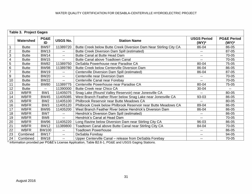
Condition 3 is updated to remove USGS gage 11405300, BW24, and BW23 from Table 3. Condition
3 is also updated to allow PG&E to request Deputy Director approval to modify the gaging plan,
following consultation with the Operations Group.
4.4 DeSabla Forebay Water Temperature Improvements
PG&E raises concerns that the time to submit the DeSabla Forebay Water Temperature Improvement
Plan required by Condition 9 of the certification was shortened from two years to one year between
issuance of the draft certification and the final certification. PG&E also raises concerns that Condition
9 requires an 80 percent or greater effectiveness criteria for reduction of thermal loading within the
DeSabla Forebay; PG&E contends that an 80 percent or greater effectiveness criteria will be more
strict than the level of accuracy of the instruments that measure the temperature of inflow and outflow
from the forebay, making compliance infeasible. Because PG&E is not proposing modification of the
deadline in the certification for completion of construction of the temperature reduction device required
by Condition 9, allowing PG&E two years to complete the plan instead of one will have no adverse
impact on water quality and is reasonable. It is also reasonable, based on the accuracy of the
instruments that measure the temperature of inflow and outflow from the forebay, that the criteria for
reduction of thermal loading within DeSabla Forebay be set as a design target instead of an ongoing
- 6 -
compliance requirement. Accordingly, Condition 9 is changed to allow PG&E two years to file the
DeSabla Forebay Water Temperature Improvement Plan and to require that the design of the device
aim to achieve an 80 percent reduction in thermal loading, as opposed to requiring that the device in
fact at all times achieve an 80 percent reduction in thermal loading.
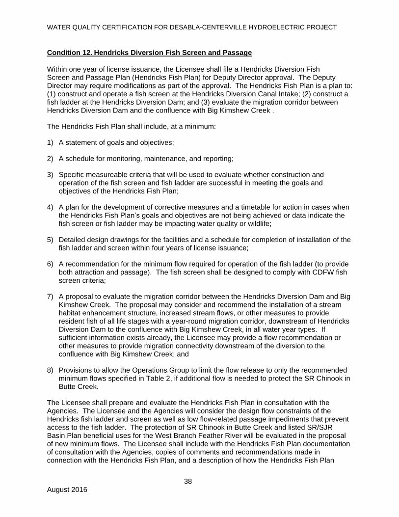
4.5 Hendricks Diversion Fish Passage
Condition 12 requires PG&E to submit a plan for review and approval by the Deputy Director to
construct a fish screen and ladder at the Hendricks Diversion Dam on the West Branch Feather River.
PG&E asserts that there are numerous natural barriers downstream of Hendricks Diversion Dam (and
outside of the FERC license boundaries) that prevent fish from migrating upstream and because of
that a fish ladder to enable fish to migrate upstream of Hendricks Diversion Dam serves no purpose.
PG&E is requesting that the requirement to construct and operate a fish ladder be deleted.
The assessment of the fish screen and ladder at Hendricks Diversion Dam was discussed in detail
during the 2009 10(j) meeting and in FERC’s 2009 Final Environmental Assessment. The directive to
develop and construct a fish ladder is ultimately to provide fish below the dam the ability to access
more thermally-suitable habitat above the dam. Condition 12 is consistent with FERC’s staff-
recommended alternative and is necessary for protection of the cold freshwater beneficial uses.
PG&E’s contention that a plan for fish passage would serve no purpose misconstrues the basis and
need for the plan and ignores the fact that the barriers downstream of dam may only prevent fish from
migrating upstream at certain low flow levels, not at all flows that may occur throughout the year. Per
the certification, the plan will identify the type of facility as well as “[a] recommendation for the
minimum flow required for operation of the fish ladder (to provide both attraction and passage).”
There is no support for PG&E’s contention that the barriers downstream of the dam are in fact at all
times barriers to upstream migration without physical modification by PG&E; PG&E can submit a flow
and fish ladder plan for approval that does not require actions unrelated to Project impacts but will
nonetheless ameliorate impacts of the Project.
In order to ensure that PG&E’s fish ladder plan does in fact serve its intended purpose, the
requirement originally included as Condition 1.B, which requires PG&E to develop a plan to evaluate
the migration corridor between the Hendricks Diversion Dam and the confluence with Big Kimshew
Creek and receive Deputy Director approval of the plan, should be incorporated into Condition 12.
- 7 -
Condition 12 is modified to clarify that provisions should be included in the plan that ensure migratory
connectivity downstream (from Hendricks Dam to the confluence with Big Kimshew Creek) and, at the
same time, allow the Operations Group to limit flow releases from Hendricks Diversion Dam into the
West Branch Feather River to those specified in Table 22 of the certification if it determines the
additional flow is needed to protect spring-run Chinook Salmon in Butte Creek.
4.6 DeSabla Forebay Fish Stocking
Condition 15 and Mitigation Measure 4 require PG&E to use United States Environmental Protection
Agency (U.S. EPA) temperature criteria to determine whether fish will be stocked in the DeSabla
Forebay or another nearby location. PG&E recommends requiring the temperature criteria used by
CDFW, which conducts the fish stocking program for the DeSabla Forebay. PG&E’s recommendation
is reasonable because U.S. EPA temperature criteria is meant to protect the longevity of wild trout
populations in native streams, whereas the CDFW temperature criteria is specific for stocking
hatchery fish. Using the CDFW temperature criteria will allow for the maximum fishing opportunities
at DeSabla Forebay.
Condition 15 and Mitigation Measure 4 are modified to require use of the CDFW temperature criteria
for stocking fish in the DeSabla Forebay.
4.7 Wet Meadow Funding
Condition 23 requires PG&E to submit a Wet Meadow Funding Plan for Deputy Director approval.
The Wet Meadow Funding Plan must include a funding proposal to maintain the wet meadow habitat
located within Butte Creek House Ecological Reserve (Butte Creek House) for the term of the license
and any annual extensions. PG&E contends that: 1) Butte Creek House is located outside of the
Project boundary; 2) FERC has no jurisdiction over activities performed by CDFW; 3) the requirement
is outside the scope of the FERC license; and 4) if wet meadow funding is included as a condition of
the certification, FERC will not include such condition as part of the license. Despite PG&E’s
contentions, the current FERC license requires PG&E to provide funding contributions toward the
ongoing preservation and management of wet meadow habitat in Butte Creek House, as off-site
mitigation for the Project. The FERC license requirement is based on an agreement3 between PG&E
and the California Department of Fish and Game (now CDFW) from 1983 for the term of the license.
2 Footnote 1 in Table 2 (Condition 1.B) states “No diversion may occur until the minimum instream flows are
satisfied, unless required by the Operations Group and approved by the Deputy Director.” 3 Fish and Wildlife Agreement between Pacific Gas and Electric and the State of California relating to De Sabla-
Centerville Project (FERC 803), December 16, 1983.
- 8 -
Condition 23 remains unchanged as the requirement remains appropriate and related to the impacts
of the Project.
4.8 Philbrook Reservoir Instream Flow Releases
PG&E contends that the certification has inconsistent approval requirements and requests to continue
current consultation and notification practices. Condition 1.B requires approval by the Deputy Director
and FERC, following mutual agreement between United States Fish and Wildlife Service (USFWS),
NMFS, and CDFW, to modify the temperature requirement for Philbrook Creek. PG&E contends that
FERC has not requested approval authority and the State Water Board cannot require FERC to take
on this responsibility. Condition 27 requires consensus from federal and state agencies, and non-
governmental organizations (NGOs), to adjust instream flow releases from Philbrook Reservoir, and
requires the adjustments to be made within two hours following consensus. PG&E contends that
NGOs do not have any legal obligation or responsibility to protect the state’s natural resources and
are not subject to FERC’s authority or jurisdiction. PG&E also requests to change the word
“consensus” to “consultation” and to limit any required approvals to the relevant resource agencies.
Condition 1.B. is modified to require consultation with the Operations Group, remove FERC from the
list of entities that must approve modifications to the Philbrook Creek temperature requirement, and
require PG&E to notify FERC within 30 days of reaching agreement with the resource agencies
regarding modifications to the Philbrook Creek temperature requirement. Although PG&E did not
specifically raise the same issue for the consultation pertaining to Round Valley Reservoir, Condition
1.B. is also updated to modify the consultation and notification practices required for releases from
Round Valley Reservoir as described above for releases from Philbrook Reservoir. Condition 27 is
also modified to require flow adjustments to be made within a time mutually agreed to by the
Operations Group representatives from USFWS, USFS, NMFS, CDFW, and State Water Board.
4.9 The Included Reservations of Authority are Permissible Expressions of the State Water
Board’s Authority Under Section 401 of the Clean Water Act
PG&E contends that “Conditions 39 and 40 contain reservations of authority that would allow the
State Water Board to change unilaterally as an administrative matter the requirements of PG&E’s new
FERC license for the Project.” (Petition, p.12.) In making this contention PG&E misconstrues the
reservations of authority contained in the referenced conditions. Specifically, these reservations of
authority do not allow the State Water Board to change unilaterally the requirements of PG&E’s
- 9 -
license; they allow the Board to exercise its authority granted by the Clean Water Act to protect water
quality at an appropriate time in the future.
The Clean Water Act recognizes and maintains states as the primary authority over water quality
within their boundaries. (33 U.S.C. § 1251 (b).) Section 401 of the Clean Water Act anticipates that
water quality certifications will not only set limits on operations, but will also monitor operations on an
ongoing basis. (33 U.S.C. § 1341 (d).) It would be counter to the Clean Water Act to read into it a
limitation that states are prohibited from acting to ensure that a facility continues to comply with water
quality standards.
Conditions of certification must be reviewed by the state court system. (See American Rivers Inc. v.
FERC (2nd Cir. 1997) 129 F.3d 99 [overruling FERC’s refusal to incorporate conditions of water
quality certification, including reservations of authority].) Although the State Water Board has
routinely included reservations of authority in the water quality certifications it issues, the issue has
not reached the California appellate courts, so there is no California precedent specifically addressing
the issue. There are precedents in other states, however. The high courts of Maine, for example, has
upheld conditions allowing the reopening or amendment of water quality certification. (S.D. Warren
Co. v. Bd. of Environmental Protection (Me. 2005) 868 A.2d 210, 218-220 aff’d on other grounds
(2006) 547 U.S. 370.) Similarly, federal agencies with mandatory conditioning authority over FERC
licenses may adopt conditions that reserve authority to require additional approvals under specified
conditions. (See, e.g. Southern California Edison Co. v. FERC (D.C. Cir. 1997) 116 F.3d 507, 519.)
To support its contention that the Board’s reservations of authority “are outside the scope of the new
license to be issued by FERC,” PG&E quotes, in part, language from section 6 of the Federal Power
Act. (16 U.S.C. § 799.) Section 6, in addition to the language quoted by PG&E regarding alteration of
licenses, makes it clear that every license “shall be conditioned upon acceptance by the licensee of all
of the terms and conditions of this chapter and such further conditions, if any, as the Commission
shall prescribe in conformity with this chapter, which said terms and conditions and the acceptance
thereof shall be expressed in said license.” (Id.) PG&E also points the Board to section 401 of the
Clean Water Act. According to the plain language of section 401, “Any certification provided under
this section ... shall become a condition on any Federal license or permit subject to the provisions of
this section.” (33 U.S.C. § 1341 (d).) Read together, conditions of a water quality certification issued
pursuant to section 401 of the Clean Water Act are conditions of a licensee’s acceptance of the
Federal Power Act license. As such, exercise of those conditions does not constitute unilateral
- 10 -
alteration of the license such that section 6 requires “mutual agreement” between the licensee and the
Commission.
Furthermore, the courts have already addressed reservations of authority in the context of section 6 of
the Federal Power Act. In State of California v. Federal Power Commission (1965) 345 F.2d 917, the
9th Circuit Court of Appeal addressed, in part, the contention that the Federal Power Commission’s
reservation of authority to modify stream flows at some time in the future violated section 6. In that
case, Turlock and Modesto Irrigation Districts asserted that the Federal Power Commission violated
section 6 “by ordering the issuance of a license which did not state all of its terms and conditions.”
(Id., at p. 924.) The court, in upholding the license condition reserving the Federal Power
Commission’s authority to modify the license under certain circumstances in the future, concluded:
The section 6 requirement that the terms and conditions of a license be expressed in the license must not be given a construction which is impracticable of application. When the Commission reasonably foresees the possibility that a need may develop years in the future requiring, in the public interest, the imposition of a burden upon the licensee at that time, but either the dimensions of the need or the way of meeting it is not presently ascertainable, the license terms cannot possibly speak with definiteness and precision concerning the matter. Under these circumstances, it is sufficient, under section 6, to include in the license a condition reserving the problem, including the licensees' rights to test the validity of any future action taken. The principle applicable here is analogous to that which obtains in determining whether the Commission order must contain specific findings of fact as to future conditions. We dealt with that problem in Portland General Electric Co. v. F.P.C., 9 Cir., 328 F.2d 165, 175. We there held that it is not arbitrary, unreasonable, or a deprivation of due process to refrain from making findings as to what conditions may be in the future, at least where no present burden is imposed.
(Id., at pp. 924-25. See also Wisconsin Public Service Corp. v. FERC (7th Cir. 1994) 32 F.3d 1165,
1168-69 [upholding reopener clauses requiring construction and operation of fishways as may be
prescribed in the future by the United States Fish and Wildlife Service.]) PG&E cites to no legal
authority supporting a different conclusion.
The alternative would be that the Board conditions its water quality certifications in such a way that
ensures the construction and operation of a project under a 30- to 50-year FERC license would be
protective of water quality for the duration of that license, taking into account potential changes to the
baseline assumptions and current conditions. The conditions of such a certification would likely be
prohibitively burdensome and be tantamount to a denial of water quality certification in many cases.
Conditions 39 and 40 remain unchanged as the requirements remain appropriate.
- 11 -
4.10 It Is Appropriate and Not Inconsistent With the Clean Water Act that the Certification Is
Subject to Modification or Revocation Upon Administrative or Judicial Review
PG&E disagrees in part with Condition 51 of the certification, namely with the fact that the certification
is subject to “modification or revocation upon administrative or judicial review….” (Petition, p. 12.) To
support this contention, PG&E cites to Section 6 of the Federal Power Act. (16 U.S.C. § 799.)
Condition 51 of the certification reflects one of the State Water Board’s standard conditions listed in
California Code of Regulations, title, 23, section 3860, specifically subdivision (a). Inclusion of these
terms in water quality certifications is not discretionary. (Cal. Code Regs., tit. 23, § 3860 [“The
following shall be included as conditions of all water quality certification actions….”].) PG&E does not
present a compelling reason why the Board should not follow its regulations here.
Nothing in section 401 of the Clean Water Act or Section 6 of the Federal Power Act supports a
different conclusion. To the contrary, the condition is consistent with the principles of federalism
embodied in Section 401 of the Clean Water Act. Review of state water quality certification orders is
in state court. (See American Rivers Inc. v. FERC, 129 F.3d at p. 108.) A reviewing court with
authority to review the validity of an administrative order may require the agency to set aside that
order. (See Code Civ. Proc., § 1094.5, subd. (f).) Denying a reviewing court that power, under
circumstances where the court determines that revocation is the appropriate remedy under state law,
would be inconsistent with respect to state law, state procedures and state institutions.
4.11 Condition 41 (Climate Change) Is Appropriate and Related to the Project
PG&E contends that Condition 41 inappropriately requires PG&E to mitigate for a harm to which the
Project is not contributing, namely, climate change in general, suggesting that, because “the Project is
not a cause of climate change” there is no nexus between the Project and the condition. PG&E
misses the point of this condition.
Future changes in climate projected to occur during the license term may significantly alter the baseline assumptions used to develop the conditions of this [water quality certification]. The State Water Board reserves authority to add to or modify the conditions in this WQC to require additional monitoring and/or other measures, as needed, to verify that Project operations meet water quality objectives and protect the beneficial uses assigned to Project-affected stream reaches.
(Certification, p. 52, emphasis added.) This condition does not hold PG&E responsible for causing
climate change through its Project operations; this condition, like the other reservations of authority
discussed above, reflects the fact that the baseline assumptions upon which the conditions of the
certification are based are likely to change over the duration of the license term. As such, and in
- 12 -
order to verify that the Project will continue to meet water quality objectives and protect the beneficial
uses assigned to Project-affected stream reaches for the duration of the license term, the Board
needs to reserve its authority to modify or add conditions to the certification as environmental
conditions beyond the control of PG&E change. Thus, Condition 41 has not been included to require
PG&E to mitigate for the impacts of climate change, but to mitigate the impacts of its Project on the
environment under a changed-climate scenario. Because the Board cannot determine with any
reasonable degree of specificity at this time what modifications may be necessary in the future, it has
left that question to be answered when and if relevant information becomes available. State Water
Board Resolution 2008-0030 “Directs Water Boards’ staff to require sustainable water resources
management such as LID [low impact development] and climate change considerations, in all future
policies, guidelines, and regulatory actions.” Condition 41 adheres to the State Water Board’s
direction by including climate change considerations and the associated need for adaptive
management in the certification.
As with the other reservations of authority, it is entirely possible that there will be no need during the
term of the FERC license, and any subsequently issued annual licenses, for the Board to exercise this
reserved authority. However, by reserving the authority in case it is needed, the Board is able to
certify that the Project will meet water quality objectives and protect the beneficial uses for the
duration of the license.
Condition 41 remains unchanged as the requirement remains appropriate.
4.12 Conditions 42 and 43 – Basin Plan Compliance
As issued, Condition 42 of the certification reads, in part, “The Licensee shall comply with all
applicable requirements of the [Water Quality Control Plan for the Sacramento and San Joaquin River
Basins].” Condition 43 similarly requires that “the Project be operated in a manner consistent with all
water quality standards and implementation plans adopted or approved pursuant to section 303 of the
Clean Water Act. The Licensee must take all reasonable measures to protect the beneficial uses of
waters of Butte Creek and the West Branch Feather River and tributaries to both waterways.” PG&E
objects to these conditions as unduly vague. In making this contention, PG&E suggests that it cannot
determine “which of the literally hundreds of requirements contained in the [Water Quality Control
Plan for the Sacramento and San Joaquin River Basins] are in fact applicable” and require PG&E to
“guess as to what the ‘applicable requirements’ were at any given time.” (Petition, p. 13.) Compliance
with the applicable terms of the relevant Water Quality Control Plan (basin plan) is a common
- 13 -
condition of certification and it is not unreasonable for the Board to require the owners and operators
of projects subject to certification to determine which conditions of the relevant basin plan are
applicable to their project.
PG&E also suggests it is “unfair for a compliance determination to hinge on a lengthy and, in many
respects, general document that is routinely changed from time to time.” (Petition, p. 13.) All
requirements of a certification depend to some degree upon the opinion of future regulators as to what
may or may not have been intended when the original requirements were imposed. This is no
different. Furthermore, PG&E has the same opportunity to comment on any changes to the Basin
Plan that could implicate its Project as any other member of the regulated community. Amendments
to basin plans are quasi-legislative activities and as such are afforded significant process before
action is taken. If PG&E believes that a requirement of the Basin Plan may be applicable to its Project
and thus compliance with that requirement is a condition of this certification, it can comment prior to
adoption of any such requirement or change to a requirement.
Conditions 42 and 43 remain unchanged as the requirements remain appropriate.
4.13 Changes to the Project
Another condition that PG&E specifically objects to is Condition 49, by which the Board requires
PG&E to submit any change to the Project that could have a significant or material effect on the
findings, conclusions, or conditions of the certification, to the Board for prior review and written
approval. PG&E objects to Condition 49 on the grounds that it requires guessing about whether any
change to the Project could have an effect on the findings, conclusions, or conditions of the
certification.
As discussed in regard to Condition 41 above, the State Water Board has an obligation to certify that
the Project will meet water quality objectives and condition the Project to be protective of the
beneficial uses assigned to Project-affected stream reaches for the duration of the license term.
Accordingly, the Board needs to reserve its authority to modify or add conditions to the certification in
response to proposed changes to the Project that could have a significant or material effect on the
findings, conclusions, or conditions of the certification. And similar to Conditions 42 and 43, as
discussed above, it is not unreasonable for the Board to require the owners and operators of projects
subject to certification to determine what potential changes to their project could have an effect on the
findings, conclusions, or conditions of the certification, but would fall short of requiring a license
amendment and possibly a separate water quality certification. State Water Board staff will continue
- 14 -
to be receptive and responsive to any queries about potential changes to the Project and will work
with PG&E staff to resolve any such issues.
Condition 49 remains unchanged as the requirement remains appropriate.
4.14 Ground Disturbing Activities
Condition 50 requires PG&E to notify the Deputy Director and the Executive Officer of the Central
Valley Water Board one week prior to starting ground disturbing activities. PG&E contends that this
broad notification requirement could hinder regular operations and maintenance, and requests to limit
the condition requirement to ground disturbing activities that require a permit. One of the purposes of
this certification is to ensure water quality will not be negatively affected for the duration of the license.
Therefore, Condition 50 is modified to limit the notification requirement to ground disturbing activities
that may adversely affect water quality. If additional federal permits are required for work with the
potential to discharge into waters of the United States, the Licensee must also obtain all appropriate
environmental review documentation and water quality certification or other necessary approvals from
the state.
4.15 Butte Creek Adjudication and Upper Centerville Canal
Mitigation Measure 3 states that PG&E is required to provide 1.175 cfs flow to water users along the
Upper Centerville Canal from the current release point in the DeSabla Forebay dam. PG&E contends
that statement is factually incorrect since PG&E is required by the Butte Creek Adjudication Order of
Determination4 to supply six water users along the Upper Centerville Canal with 1.175 cfs only when
water is flowing in the Butte Canal. PG&E suggests modifying Mitigation Measure 3 to clarify that only
when PG&E is operating the Upper Centerville Canal, 1.175 cfs flow must be delivered to water users
along the Upper Centerville Canal.
Neither Mitigation Measure 3 nor the water quality certification are intended to alter any rights or
requirements of that decree5, and modification of the rights or requirements of the decree is not part of
PG&E’s proposed project addressed by the certification. Independent of the Butte Creek Adjudication
Order of Determination, Mitigation Measure 3 includes a requirement for PG&E to release a bypass
flow of at least 2 cfs from the upstream end of the temperature reduction device to provide some
circulation through DeSabla Forebay and reduce the risk of stagnation in the DeSabla Forebay pool.
4 Order of Determination issued by the State of California Department of Public Works, April 14, 1942, p. 27.
5 Butte Creek Judgment and Decree, November 6, 1942.
- 15 -
Mitigation Measure 3 is modified to state that PG&E is required to provide 1.175 cfs of flow to water
users along the Upper Centerville Canal in the manner identified in the Butte Creek water rights
decree. Mitigation Measure 3 is further modified to clarify that PG&E is required to bypass when
operating the temperature reduction device.
4.16 Additional Consistency Updates
For internal consistency, the certification is also updated where appropriate (e.g., rationale) to reflect
the substantive changes made to the certification by this order.
5. CONCLUSION
For the reasons discussed above, the petition for reconsideration is granted in part. The certification
will be amended as described in this order. As amended by and attached to this order, the
certification is appropriate and proper.
6. ORDER
IT IS HEREBY ORDERED that the certification of PG&E’s new license for FERC Project No. 803 for
purposes of compliance with section 401 of the Clean Water Act is amended as attached to this order.
CERTIFICATION
The undersigned Clerk to the Board does hereby certify that the foregoing is a full, true, and correct copy of an order duly and regularly adopted at a meeting of the State Water Resources Control Board held on August 2, 2016. AYE: Chair Felicia Marcus Vice Chair Frances Spivy-Weber Board Member Steven Moore Board Member Dorene D’Adamo
NAY: None
ABSENT: Board Member Tam M. Doduc
ABSTAIN: None
Jeanine Townsend Clerk to the Board Attachment
WATER QUALITY CERTIFICATION FOR DESABLA-CENTERVILLE HYDROELECTRIC PROJECT
1 August 2016
STATE OF CALIFORNIA STATE WATER RESOURCES CONTROL BOARD
In the Matter of Water Quality Certification for the
PACIFIC GAS AND ELECTRIC COMPANY
DESABLA-CENTERVILLE HYDROELECTRIC PROJECT
FEDERAL ENERGY REGULATORY COMMISSION PROJECT NO. 803 SOURCES: Butte Creek and West Branch Feather River COUNTY: Butte
WATER QUALITY CERTIFICATION FOR FEDERAL PERMIT OR LICENSE BY THE EXECUTIVE DIRECTOR:
1.0 Introduction
On October 2, 2007, Pacific Gas and Electric Company (PG&E or Licensee) filed an application for a new license (license application) for the DeSabla-Centerville Hydroelectric Project (Project) with the Federal Energy Regulatory Commission (FERC). The Project, also known as FERC Project No. 803, was issued a minor-part license for portions of the Project located on Federal lands by the Federal Power Commission (precursor to FERC) in 1929, which expired on October 11, 1979. The current license for the Project was issued on June 11, 1980, and expired October 11, 2009. The Project operates under annual licenses issued by FERC until the new license is issued. Certain aspects of the proposed Project may require authorization from the United States Army Corps of Engineers (ACOE) under section 404 of the Clean Water Act. The Project has an installed capacity of 25.8 megawatts (MW) and is located on Butte Creek and the West Branch Feather River in Butte County, California. The Project consists of three developments (Toadtown, DeSabla, and Centerville), which collectively include three reservoirs, three powerhouses, 14 diversion and feeder dams, five canals, and associated equipment and transmission facilities. The flow of water through each development is described below and generally follows the flow of water through the Project (see Figure 1). 1) The Toadtown Development diverts water from the West Branch Feather River
watershed to the DeSabla Development in the Butte Creek watershed via the Hendricks, Toadtown and Butte Creek Canals.
WATER QUALITY CERTIFICATION FOR DESABLA-CENTERVILLE HYDROELECTRIC PROJECT
2 August 2016
2) The DeSabla Development diverts water from the West Branch Feather River that passed through the Toadtown Development and water from Butte Creek. Water is diverted from upper Butte Creek at the Butte Diversion Dam and is comingled with water flowing out of the Toadtown Development (via Hendricks, Toadtown and Butte Creek Canals) into the DeSabla Forebay, and then back into Butte Creek after passing through the DeSabla Powerhouse. Water diverted at the Butte Diversion Dam bypasses approximately 11 river miles of Butte Creek.
3) The Centerville Development diverts a portion of the flow of Butte Creek downstream of
the DeSabla Development at the Lower Centerville Diversion Dam. Water diverted at the Lower Centerville Diversion Dam bypasses approximately nine river miles of Butte Creek. During non-operation of the Centerville Powerhouse, water from the Lower Centerville Canal is discharged into Butte Creek roughly 1,000 feet upstream of the Centerville Powerhouse. During operation of the Centerville Powerhouse, water is discharged into Butte Creek immediately downstream of the Centerville Powerhouse.
The diversions in the Project area have reduced flows in the natural channel of Butte Creek and the lower portion of the West Branch Feather River. Diversions into Butte Canal and the Lower Centerville Canal reduce the flows in Butte Creek. Diversions into the Hendricks and Toadtown Canals reduce the flows in the West Branch Feather River. The Centerville Powerhouse, constructed in 1900, was determined to be near the end of its useful life in a 2005 assessment conducted by PG&E. The Centerville Powerhouse has been out of service since June 2009. While PG&E initiated some refurbishment of the powerhouse, it is currently not operational. The DeSabla Powerhouse was built in 1963.
The National Marine Fisheries Service (NMFS) listed the Central Valley spring-run Chinook salmon (SR Chinook) Evolutionary Significant Unit (ESU) as threatened under the federal Endangered Species Act (ESA) (16 U.S.C. 1531-1544) on September 16, 1999 (NOAA 1999). Also, SR Chinook in the Sacramento River Basin is listed as threatened under the California ESA (Fish and Game Code, §§ 2050 et seq.) (CDFW 1998). Historically, SR Chinook were the dominant run in the Sacramento River Basin. SR Chinook typically occupies the middle and upper elevation reaches of rivers that have sufficient adult holding habitat through the summer. Critical habitat for the SR Chinook ESU was designated on September 2, 2005 (NOAA 2005). Butte Creek contains the largest population in the ESU. Butte Creek SR Chinook are unique and are genetically distinct from other Chinook salmon populations. Since the listing of SR Chinook, PG&E has operated the Project to enhance and protect the habitat for this species. The license application states that a “significant primary benefit” of the Project is “enhanced cool water habitat for threatened SR Chinook and Central Valley steelhead in Butte Creek.” NMFS rated the conservation value of Butte Creek as high due to the high quality holding and spawning habitat. The Central Valley California ESU of steelhead trout was listed under the federal ESA as threatened in March of 1998 (NOAA 1998). Data on Butte Creek steelhead are restricted to incidental observations by anglers and California Department of Fish and Wildlife (CDFW; formerly known as California Department of Fish and Game) staff.
WATER QUALITY CERTIFICATION FOR DESABLA-CENTERVILLE HYDROELECTRIC PROJECT
3 August 2016
2.0 Regulatory Authority 2.1 Water Quality Certification The Federal Clean Water Act (33 U.S.C. §§ 1251-1387) was enacted “to restore and maintain the chemical, physical, and biological integrity of the Nation’s waters.” (33 U.S.C. § 1251(a).) Section 101 of the Clean Water Act (33 U.S.C. § 1251 (g)) requires federal agencies to “co-operate with the state and local agencies to develop comprehensive solutions to prevent, reduce and eliminate pollution in concert with programs for managing water resources.” Section 401 of the Clean Water Act (33 U.S.C. §1341) requires every applicant for a federal license or permit which may result in a discharge into navigable waters to provide the licensing or permitting federal agency with certification that the project will be in compliance with specified provisions of the Clean Water Act, including water quality standards and implementation plans promulgated pursuant to section 303 of the Clean Water Act (33 U.S.C. § 1313). Clean Water Act section 401 directs the agency responsible for certification to prescribe effluent limitations and other limitations necessary to ensure compliance with the Clean Water Act and with any other appropriate requirement of state law. Section 401 further provides that state certification conditions shall become conditions of any federal license or permit for the project. The State Water Resources Control Board (State Water Board) is designated as the state water pollution control agency for all purposes stated in the Clean Water Act and any other federal act (Wat. Code section 13160.). The State Water Board has delegated authority to act on applications for water quality certification (certification or WQC) to the Executive Director. PG&E originally applied for WQC on June 17, 2008, and has annually withdrawn and re-applied for WQC. On December 2, 2011, the State Water Board provided public notice of PG&E’s application for WQC pursuant to California Code of Regulations, title 23, section 3858. Comments are posted on the State Water Board’s Water Quality Certification Program webpage: http://www.swrcb.ca.gov/waterrights/water_issues/programs/water_quality_cert/desabla_ferc803.shtml. On April 18, 2015, the State Water Board’s Executive Director issued the WQC for the Project. On May 8, 2015, PG&E submitted a petition for reconsideration of the WQC for the Project. The State Water Board considered PG&E’s petition for reconsideration at its August 2, 2016 meeting and adopted this updated WQC. 2.2 Water Quality Standards and Water Quality Control Plans The California Regional Water Quality Control Boards (Regional Water Boards) adopt, and the State Water Board approves, water quality control plans (basin plans) for each watershed basin in the state. The basin plans designate the beneficial uses of waters within each watershed basin, and water quality objectives designed to protect those uses pursuant to Section 303 of the Clean Water Act (33 U.S.C. § 13130). The beneficial uses and water quality objectives that are contained in the basin plans, together with state and federal anti-degradation requirements, constitute California’s water quality standards. The Water Quality Control Plan for the Sacramento River and San Joaquin River Basins (SR/SJR Basin Plan) does not specifically identify the beneficial uses of the West Branch Feather River. The SR/SJR Basin Plan specifies that the beneficial uses of any specifically identified water body generally apply to its tributary streams. Therefore, the West Branch Feather River beneficial uses are listed under the Lake Oroville designation. Designated beneficial uses for the West Branch Feather River (Lake Oroville designation) include: municipal and domestic supply; irrigation; power; contact recreation; other non-contact recreation; cold
WATER QUALITY CERTIFICATION FOR DESABLA-CENTERVILLE HYDROELECTRIC PROJECT
4 August 2016
freshwater habitat; warm freshwater habitat; warm freshwater spawning; cold freshwater spawning; and wildlife habitat. The existing beneficial uses for Butte Creek (sources to Chico), as designated in the SR/SJR Basin Plan, are: municipal and domestic supply; irrigation; stock watering; power; contact recreation; cold freshwater habitat; warm freshwater habitat; cold freshwater migration; warm freshwater spawning; cold freshwater spawning; and wildlife habitat. 2.3 Construction General Permit The State Water Board has adopted a General Permit for Stormwater Discharges Associated with Construction and Land Disturbance Activities (Construction General Permit; Water Quality Order 2009-0009-DWQ and National Pollutant Discharge Elimination System [NPDES] No. CAS000002, as amended by Order Nos. 2010-0014-DWQ and 2012-0006-DWQ). The Construction General Permit is required for activities that disturb one or more acres of land or whose projects disturb less than one acre but are part of a larger common plan of development that in total disturbs one or more acres. Construction activities subject to the Construction General Permit include clearing, grading and disturbances to the ground such as stockpiling or excavation. PG&E will be required to comply with the Construction General Permit when conducting the activities that fall within its purview.
2.4 Water Rights PG&E holds several state-issued water rights for non-consumptive use of water for power generation, fish and wildlife enhancement, and recreation. These include one License for Diversion and Use of Water (License No. 988, Application No. A002755) and two Permits for Diversion and Use of Water (Permit No. 18068, Application No. A025967 and Permit No. 21194, Application No. A031518). PG&E has also filed Statements of Water Diversion and Use for 13 active pre-1914 claims of water use related to the Project.
3.0 Water Quality Certification Conditions This WQC will become part of the FERC 30-to-50-year license for the Project. Certain changes in the physical environment, the regulatory environment, and the state of scientific understanding are anticipated during this time. The scope of such changes cannot, however, be determined with sufficient specificity at the present time. It is therefore impossible to determine what additional conditions would be required to ensure that the Project is protective of water quality standards throughout the license period. For this reason, some terms and conditions include reservations of authority and/or adaptive management provisions to address these uncertainties. The State Water Board developed WQC conditions based upon: (1) measures recommended by PG&E and FERC staff; (2) measures prepared to address requirements in the Federal Power Act (FPA), specifically: Section 4(e) (16 USC §§ 797(e)); Section 10(j) (16 USC §§ 803(j)); and Section 18 (16 USC §§ 811); and (3) measures necessary to meet water quality standards. The United States Forest Service (USFS) and the Bureau of Land Management (BLM) developed the 4(e) conditions, CDFW developed the 10(j) recommendations; and NMFS developed the Section 18 requirements. Some of these underlying measures, however, are not enforceable, do not include sufficient or specific time lines for completion, will not protect beneficial uses, will not meet water quality standards in a timely manner, or contain conflicting or inconsistent requirements. Though the WQC conditions may modify the underlying measures or other agency conditions to provide assurance that the beneficial uses will be reasonably protected,
WATER QUALITY CERTIFICATION FOR DESABLA-CENTERVILLE HYDROELECTRIC PROJECT
5 August 2016
the WQC conditions are intended to be consistent with the underlying measures and agency conditions.
4.0 Rationale for the Water Quality Certification Conditions When preparing the conditions in this certification, State Water Board staff reviewed and considered: (a) PG&E’s final FERC license application; (b) comments on the final license application submitted by agencies and interested parties; (c) USFS and BLM Final 4(e) Conditions; (d) FERC Environmental Assessment (EA) prepared pursuant to the National Environmental Policy Act (42 U.S.C §§ 4321 et seq.); (e) PG&E’s application for WQC; (f) Section 18 conditions and the Draft Biological Opinion issued by NMFS; (g) recommendations under FPA section 10(a) and 10(j) and comments by agencies and interested parties; and (h) recommendations made under Public Resources Code Sections 10001-10002, Minimum Instream Flow Recommendations: Butte Creek, Butte County issued by CDFW. State Water Board staff also considered comments submitted on the draft WQC and the Initial Study (IS)/ Mitigated Negative Declaration (MND) prepared pursuant to the California Environmental Quality Act (CEQA) (Pub. Resources Code, §§ 21000 et seq.), the SR/SJR Basin Plan, existing water quality conditions, Project-related controllable factors, and other information in the record. Any conditions that require development of a plan will require review, modification (if necessary), and approval by the Deputy Director of the Division of Water Rights (Deputy Director). In addition, other regulatory agencies have specific authorities to approve plans and reports. The following describes the rationale used to develop most of the conditions in the WQC. The conditions for which additional rationale is not provided below (Conditions 30–58) are additional conditions commonly applicable to hydroelectric projects that, in this case, are necessary to ensure the protection of water quality standards over the term of the license and any annual extensions. 4.1 Minimum Instream Flows and Potential Retirement of the Centerville Development Background and rationale information on the development of minimum instream flows for the Project is broken out by waterbody in the following sub-sections as follows: (A) Butte Creek; (B) West Branch Feather River; and (C) Hendricks-Toadtown Canal. Sub-section 4.1.D provides an overview of recent discussions related to the potential retirement of the Centerville Development and related rationale and information. Sub-sections 4.1.E and 4.1.F provide background and rationale for the temporary modification of stream flows and minimum flows during extremely dry conditions, respectively. A. Butte Creek
PG&E’s existing FERC license (expired 2009, but continues under annual extensions) requires minimum flows of 40 cubic feet per second (cfs) for 10.5 months and 30 cfs for 1.5 months in normal water year types and 10 cfs year-round in dry water year types at the Lower Centerville Diversion Dam (PG&E 2004). The definitions of normal and dry water year types are provided in Condition 2 of this certification. Butte Creek minimum instream flows are met, in part, through diversions imported from the West Branch Feather River. PG&E stores winter runoff from the West Branch Feather River watershed in Philbrook and Round Valley Reservoirs. Water in Philbrook and Round Valley Reservoirs is released into the main channel of the West Branch Feather River. This imported water supplements summer flows in Butte Creek. The supplemental summer flows provided from the reservoirs into the West Branch Feather River
WATER QUALITY CERTIFICATION FOR DESABLA-CENTERVILLE HYDROELECTRIC PROJECT
6 August 2016
are limited; the combined storage capacity of Philbrook and Round Valley Reservoirs is 6,200 acre-feet (NOAA 2006).
Flow in the Lower Centerville Canal is returned to Butte Creek immediately downstream of the Centerville Powerhouse when the Centerville Powerhouse is in operation, and approximately 1,000 feet upstream of the Centerville Powerhouse when the Centerville Powerhouse in not in operation. A United States Fish and Wildlife Service (USFWS) study of SR Chinook spawning habitat between Centerville Diversion Dam and Parrot–Phelan Diversion Dam determined that approximately 85 percent of the spawning habitat in Butte Creek is located downstream of the Centerville Powerhouse (USFWS 2003). Meanwhile, the highest number of deep holding pools are located upstream of the Centerville Powerhouse in the three-mile stretch downstream of Quartz Bowl Pool (NMFS 2006). Due to lack of studies on Butte Creek salmon spawner movement, from the salmon holding stage through spawning, it is unknown how far SR Chinook will migrate from areas with greater holding habitat and less spawning habitat to areas with more spawning habitat. Since data on salmon spawner movement are unavailable, it is speculated that redd superimposition may occur in the portion of Butte Creek upstream of the Centerville Powerhouse.
Current minimum instream flows, as a result of diversions into the Lower Centerville Canal, affect the quantity and quality of holding and spawning habitat for SR Chinook. During the spawning and incubation periods, lower minimum bypass flows in Butte Creek at the Lower Centerville Diversion Dam increase temperatures and reduce the amount of submerged spawnable gravels with adequate flows, thus significantly reducing available spawning habitat for SR Chinook in Butte Creek between the Lower Centerville Diversion Dam and the Centerville Powerhouse (USFWS 2003).
In addition, diversions into Lower Centerville Canal can cause pre-spawn mortality and may create a thermal barrier to fish migration upstream of the Centerville Powerhouse. The Preliminary Biological Opinion (NMFS 2006) for the Project documents how high water temperature and high fish densities in Butte Creek in 2003 led to disease outbreaks in SR Chinook that resulted in pre-spawn mortality. Surviving fish exposed to high water temperatures may experience reduced fecundity (Lindley et al. 2007). Higher flows into Butte Creek from the Lower Centerville Diversion Dam to the Centerville Powerhouse, will reduce the water temperatures in Butte Creek and will increase the amount of spawning and holding habitat.
During relicensing, CDFW staff recommended flows for spawning and rearing of 100 cfs in wet water years and 75 cfs in dry water years from September 1 through March 31. CDFW staff also recommended flows of 40 cfs from July 1 to August 31 in all water year types. Condition 1 includes minimum flows for Butte Creek downstream of the Lower Centerville Diversion Dam that are similar to those recommended by CDFW’s 2008 Minimum Instream Flow Recommendations: Butte Creek, Butte County (CDFW 2008). The 2008 CDFW report recommended flows considers Project operations under the current license, to allow for greater dispersal of redds, and to reduce redd superimposition.
CDFW and some relicensing participants expect that during the existing summer period 40 cfs flow will continue to create a thermal barrier upstream of the Centerville Powerhouse for SR Chinook and steelhead (Shutes et al. 2008). NMFS staff contends that 40 cfs flow between the Lower Centerville Diversion Dam and the Centerville Powerhouse during the existing summer period will continue to create a Project-created thermal barrier that harms all freshwater life stages of SR Chinook due to the loss of holding, spawning, and rearing habitat, injury, and death from Project-related elevated temperatures (NOAA 2006). In summary, the thermal barrier created by the 40 cfs in the summer period creates “take.” Increasing flows for a portion
WATER QUALITY CERTIFICATION FOR DESABLA-CENTERVILLE HYDROELECTRIC PROJECT
7 August 2016
of the summer period in Butte Creek will decrease “take.” Given the similarity of habitat needs for steelhead and resident rainbow trout, these factors also apply to steelhead and resident rainbow trout.
Even though higher flows in Butte Creek will reduce the water temperature and will increase the amount of spawning and holding habitat, there is a lack of consensus among the participating agencies1 regarding optional instream flows in Butte Creek. Technical disagreement centers on whether it would be more beneficial to salmon, than existing conditions, to increase flows in the reach of Butte Creek between the Lower Centerville Diversion Dam and the Centerville Powerhouse. During relicensing, the participating agencies consulted with one another regarding various flow scenarios involving Lower Centerville Diversion Dam, Centerville Powerhouse and the DeSabla Forebay Water Temperature Reduction Device. Participating agencies involved in the Project relicensing favor one or the other of the two Butte Creek flow scenarios outlined below. Both scenarios include installation of the DeSabla Forebay Water Temperature Reduction Device.
Scenario 1
Under the first Butte Creek scenario, operations would continue per the existing license. Up to 180 cfs would continue to be diverted from Butte Creek at the Lower Centerville Diversion Dam, and subsequently be discharged back into Butte Creek at the Centerville Powerhouse. The minimum release of 40 cfs in the bypass reach upstream of the Centerville Powerhouse in Butte Creek (bypass reach) would continue. According to CDFW data for 2003 through 2005, the semimonthly mean daily temperature of the water that flowed through the Lower Centerville Canal that discharged at the Centerville Powerhouse increased by 0.5°C to 0.7°C. Water released into the natural channel of Butte Creek at the Lower Centerville Diversion Dam (i.e., not diverted into the Lower Centerville Canal) increased by 1.5°C to 3.2°C. Water temperatures in the Lower Centerville Canal remain suppressed in part due to the speed and reduced thermal exposure of water in the Lower Centerville Canal. The cooler water released from the Lower Centerville Canal benefits the SR Chinook holding in habitat downstream of the Centerville Powerhouse. With the diversions into the Lower Centerville Canal, water temperatures 0.6 miles downstream of the Centerville Powerhouse at Centerville Estates are similar to water temperatures at Pool 42. Water temperatures at Centerville Estates in July through August of 2001-2005 were approximately 1°C cooler to 0.8°C warmer than the water in Butte Creek at Pool 4 (Ward, McReynolds, and Garman 2005). With cold-water releases in Butte Creek at the Lower Centerville Diversion Dam and at the Centerville Powerhouse, populations of SR Chinook are distributed into two randomly sized groups. One group is distributed in holding habitat in the 5.7 mile stretch between the Centerville Powerhouse and downstream to the Covered Bridge. The other group is distributed in 5.6 river miles of holding habitat between the Quartz Bowl Pool and downstream to the Centerville Powerhouse. This SR Chinook group segregation results from temperature conditions near the Centerville Powerhouse and associated fish preference to hold in a location or continue to migrate upstream. Temperature and other habitat conditions change in response to Project operations.
1 Participating agencies include but are not limited to the State Water Board, CDFW, BLM, USFS, USFWS, and
NMFS. 2 Pool 4 is located upstream of the Centerville Powerhouse and 2.73 miles upstream of Centerville Estates.
WATER QUALITY CERTIFICATION FOR DESABLA-CENTERVILLE HYDROELECTRIC PROJECT
8 August 2016
CDFW staff consulted with a CDFW fish pathologist on August 4, 20033 about the possibility of a disease outbreak in the holding habitat on Butte Creek under Scenario 1. The fish pathologist predicted that if the holding habitat becomes overcrowded during an extended heat event and a disease outbreak occurs, there would be insufficient cold water for flushing flows due to the limited cold water supply in Philbrook Reservoir. Scenario 2 Under Scenario 2, diversions from Butte Creek at the Lower Centerville Diversion Dam would cease. The water temperature effects of this scenario were analyzed using the water temperature model CE-QUAL-W2 developed by PG&E. The cessation of diversions at the Lower Centerville Diversion Dam is referred to in this document as the release of full flows into Butte Creek (i.e., no flow diverted into the Lower Centerville Canal). Full flows into Butte Creek, along with the reduction of thermal loading at the DeSabla Forebay, will benefit adult SR Chinook holding habitat upstream of the Centerville Powerhouse and will result in additional summer holding habitat. According to the modeling results, following installation of the DeSabla Forebay Water Temperature Reduction Device, full flows into Butte Creek will result in lower water temperatures upstream of the Centerville Powerhouse, and temperatures equal to or slightly lower than the base condition downstream of the Centerville Powerhouse. In other words, according to the temperature model, full flows at Lower Centerville Diversion Dam into Butte Creek will not increase water temperatures downstream of the Centerville Powerhouse. The lower temperatures will benefit salmonids and will not have a negative effect on salmon holding habitat downstream of the Centerville Powerhouse. Condition 1 was developed with consideration of the technical disagreement regarding the appropriate optimum instream flows for salmon in Butte Creek, as outlined in Scenarios 1 and 2 above. Condition 1 requires PG&E to perform the full flow test described in Scenario 2, which will provide the information necessary to inform resolution of the technical disagreement. Condition 1 also requires PG&E to operate the Project according to FERC Orders that prescribe water temperature requirements (FERC 1997 and FERC 1998). These FERC Orders place temperature restrictions on releases from Round Valley and Philbrook Reservoirs. The FERC 1998 Order allows for modification of releases from Round Valley and Philbrook Reservoirs upon the mutual agreement of USFWS, NMFS, and CDFW, and as subsequently incorporated into the annual Project Operations and Management Plan (Condition 17).
B. West Branch Feather River
In the license application, PG&E recommends a flow of 30 cfs (normal water year) and 20 cfs (dry water year) between March 1 to May 31, and flow of 20 cfs (normal water year) and 7 cfs (dry water year) from June 1 to February 28/29. In the Final EA, FERC staff recommends a flow of 7 cfs downstream of the Hendricks Diversion Dam during dry years, while acknowledging that passage between Big Kimshew Creek and Hendricks Diversion Dam may be questionable at a minimum instream flow of 7 cfs.
The flow habitat relationship model (Physical Habitat Simulation System, PHABSIM) developed by PG&E (Final License Application, Volume IIB, Section 6.3.2.8) shows the maximum habitat (weighted usable area), in the West Branch Feather River downstream of the Hendricks
3 Email from Tracy McReynolds, Staff Environmental Scientist, CDFW, Chico, California, to Amber Villalobos, dated
November 13, 2012 (CDFW 2012).
WATER QUALITY CERTIFICATION FOR DESABLA-CENTERVILLE HYDROELECTRIC PROJECT
9 August 2016
Diversion Dam, occurs at a flow of 135 to 190 cfs for adult trout, 10 to 25 cfs for trout fry, and 60 to 105 cfs for juvenile trout. The FERC staff recommended flows of 15 cfs and 7 cfs are well below the flows needed for maximum habitat value. According to the FERC Project EA, under current flow conditions of 15 cfs in normal years and 7 cfs in dry years, water temperatures in the Lower West Branch Feather River do not support the cold freshwater beneficial use. During relicensing the two years of studies (2006 and 2007) showed the July through August mean daily water temperature above the Miocene Diversion ranged from 18.3°C to 22.8°C and 17.9°C to 22.9°C, respectively. The United States Environmental Protection Agency (EPA) Region 10 Guidance prescribes the following temperature criteria (based on the seven-day average of the daily maximum temperature values): 20°C for migrating salmon and trout; 13°C for spawning, egg incubation, and fry emergence for salmon and trout; and 16.0°C for “core” juvenile rearing (EPA 2003). Therefore, based on data collected during the two years of relicensing studies, the mean daily water temperatures upstream of the Miocene Diversion exceeded EPA Region 10 temperature criteria for the protection of the cold freshwater habitat beneficial use.
According to PG&E’s Stream Network Temperature modeling, minimal increases to flow (e.g., 5 – 10 cfs) downstream of the Hendricks Diversion Dam will result in substantial reductions in water temperature (e.g., 2°C - 3°C) in the approximately three-mile reach of the West Branch Feather River between Hendricks Diversion Dam and Cold Creek. However, water temperature modeling also shows there is a trade-off between higher flows downstream of the Hendricks Diversion Dam and water temperature in Butte Creek. Higher flows in Butte Creek may result in increased water temperature in the West Branch Feather River. To provide a level of safety for SR Chinook populations and the cold water beneficial uses in the West Branch Feather River, Condition 1 supports the flows consistent with CDFW’s 10(j)4 and USFS’s 4(e) at Hendricks Diversion Dam. Following initiation of operation of the DeSabla Forebay Water Temperature Reduction Device, water temperature data will be collected (Condition 9). Temperature data along with data on the operation5 of the fish ladder at Hendricks Diversion Dam will provide valuable information that is necessary to balance the tradeoff between possible increases to flow in Butte Creek and potential water temperatures increases in the West Branch Feather River. Given the current information, requirements in Condition 1 provide the best balance for the protection of the cold freshwater migration, cold freshwater habitat, cold freshwater spawning, warm freshwater habitat, warm freshwater spawning, wildlife habitat, and power beneficial uses.
C. Hendricks-Toadtown Canal
In modified 4(e) Condition 18.1, the USFS specifies that PG&E will install three pipes in the Hendricks-Toadtown Canal to deliver flows to Long Ravine, Cunningham Ravine, and Little West Fork Creek downstream of the Hendricks-Toadtown Canal. Long Ravine, Cunningham Ravine, and Little West Fork Creek are likely to support aquatic life upstream of the diversion structures. Installation of the three pipes will allow water to flow and would reestablish the habitat connectivity within Long Ravine, Cunningham Ravine, and Little West Fork Creek. Condition 1 includes a requirement that will allow flows to be released into the feeder creeks below the Hendricks-Toadtown Canal. The USFS estimates that flow through the required four-inch pipes will vary between 0.2 cfs to 0.75 cfs, depending upon the quantity of water present in the Hendricks-Toadtown Canal (FERC-EA 2009). Condition 1 also requires that
5 For purposes of determining the effectiveness of the fish ladder and any downstream migratory barrier passage
flows, ”operation” of the fish ladder includes releases of flows for attraction of fish to the Hendricks Diversion Dam ladder as well as release for fish passage of the ladder itself.
WATER QUALITY CERTIFICATION FOR DESABLA-CENTERVILLE HYDROELECTRIC PROJECT
10 August 2016
PG&E monitor the pipes to ensure the pipes do not become blocked. This condition will protect the beneficial uses of the feeder creeks.
D. Potential Retirement of Centerville Development
On January 21, 2014 and April 4, 2014, PG&E met with staff from the State Water Board, NMFS, USFWS, and CDFW to discuss a potential future amendment to the FERC license. The purpose of such an amendment would be to allow PG&E to retire the Centerville Development.
With a lack of agreement between relicensing parties regarding the two scenarios (described in section 4.1.A), and the possibility of PG&E requesting a license amendment to retire the Centerville Development, additional information is needed to determine the effect of increased Butte Creek flows on SR Chinook. Implementation of Condition 1 will provide this additional information. Condition 1 requires the Licensee to consult with NMFS, USFS, CDFW, USFWS, and the State Water Board (Agencies) regarding a “full flow test,” whereby all water would flow into Butte Creek (i.e., no diversions into Lower Centerville Canal). The data collected during the “full flow test” would be used to evaluate whether full flows are adequate to provide cold water to Butt Creek to support state- and federally-listed anadromous fish if the Lower Centerville Canal is retired as part of the Centerville Development retirement. Per Condition 1, the Licensee shall also consult on the potential for: (1) habitat restoration and/or passage at Quartz Bowl in wet and above normal water year types; (2) an egg viability study (gravel and/or holding adults); (3) notching or similar actions for Lower Centerville Diversion Dam; and (4) evaluation of the Upper Centerville Canal’s ability to provide cold water to lower Butte Creek. Passage at Quartz Bowl into adequate upstream holding habitat will alleviate potential overcrowding in Quartz Bowl. An egg viability study may reduce the number of years required to evaluate impacts of full flows on the freshwater lifecycle of federally- and state-listed cold-water anadromous fish.
A full flow test will temporarily end diversions at Lower Centerville Diversion Dam for purposes of gathering data necessary to determine whether current operation or full flows in Butte Creek downstream of the Lower Centerville Diversion Dam would be better for state- and federally-listed anadromous fish. This information will be used to determine whether PG&E may retire the Lower Centerville Canal without significant long-term negative impacts to state- and federally-listed anadromous fish populations. Based on the outcome of the consultation, PG&E will develop and submit a retirement plan to the Deputy Director for review and approval.
If the anadromous fish and benthic macroinvertebrate monitoring required in Conditions 16 and 18 indicate federally- and state-listed fish populations are being negatively impacted during the full flow testing, the Deputy Director may require: diversion into Lower Centerville Canal to resume; implementation of the flows outlined in Condition 1; and/or annual update of the Project Operations and Management Plan (Condition 17). Condition 1 requires submission of a plan for evaluation of full flows outlined above. The plan will ensure that the effect of full flows on the freshwater lifecycle of federally- and state-listed cold-water anadromous fish is evaluated and listed beneficial uses are protected if the Centerville Development or portions of the Centerville Development are retired.
WATER QUALITY CERTIFICATION FOR DESABLA-CENTERVILLE HYDROELECTRIC PROJECT
11 August 2016
E. Temporary Stream Flow Modification
The minimum instream flow requirements (outlined in Condition 1) are subject to temporary modification if required by equipment malfunction, as directed by law enforcement authorities, or in emergencies. F. Extremely Dry Conditions It is difficult to anticipate the impact of multiple dry years, an extremely dry year, or a drought, and to develop plans to manage water during such conditions. This condition provides PG&E an opportunity, after consultation with the Agencies and BLM, to request Deputy Director approval of a Revised Operations Plan during extremely dry conditions, such as multiple dry years or a drought. Condition 2 will allow the Deputy Director to balance competing beneficial uses during extremely dry conditions. 4.2 Water Year Types
Designation of water year types is necessary to balance water supply and instream flow needs. Condition 2 in the certification relies on the Department of Water Resources (DWR) Bulletin 120 as a basis of determining water year type. There is the potential for climatic changes over the life of the license that could result in an increase in ambient temperatures and decrease in precipitation, including snow fall. These changes, coupled with cold water requirements for listed species, may make it necessary to revise water year types during the life of the license. After consultation with the Operations Group6, the Licensee may request modification of water year types. A modification of water year types may result in modification of instream flows by the Deputy Director.
4.3 Stream and Reservoir Gaging Stream flow and reservoir elevation information is necessary to monitor compliance with flow requirements and for water management. Accurate monitoring of stream flows in the upper West Branch Feather River will help guide flow releases from Round Valley Reservoir for water temperature management and Project operations in both the West Branch Feather River and lower Butte Creek. In addition, accurate monitoring of flows downstream of Project reservoirs and diversions will allow the State Water Board to document compliance with required minimum instream flows.
Condition 3 requires the continued operation and maintenance of gaging stations on the West Branch Feather River downstream of Round Valley Reservoir and downstream of the Hendricks Diversion Dam. Currently, there is no gage in Philbrook Creek downstream of the confluence of both the low-level release and the spill channel. A new real-time gage will allow accurate monitoring of all flows in Philbrook Creek for better management of water temperatures in Butte Creek and the West Branch Feather River. Condition 3 also requires PG&E to convert the existing flow gages downstream of the Hendricks Diversion Dam, downstream of the Butte Creek Diversion Dam, and downstream of Lower Centerville Diversion Dam to provide real-time information.
6 The Operations Group includes representative(s) from NMFS, USFS, CDFW, USFWS, State Water Board, BLM,
California Sportfishing Protection Alliance, Friends of Butte Creek, American Whitewater, and Friends of the River.
WATER QUALITY CERTIFICATION FOR DESABLA-CENTERVILLE HYDROELECTRIC PROJECT
12 August 2016
Operation of Philbrook and Round Valley Reservoirs is critical to providing cold water to protect SR Chinook in Butte Creek. Round Valley Reservoir is a shallow reservoir. Due to Round Valley Reservoir’s shallow depth, it lacks a cold water pool. Thus, Round Valley Reservoir water is usually discharged during the early summer, when ambient conditions are cooler. Alternately, Philbrook Reservoir is deep enough to produce a cold water pool. Given the early discharge timing and lack of a cold water pool, a gage is not necessary at Round Valley Reservoir. However, the operation of Philbrook Reservoir, due to its cold water pool, is critical to temperature control. Condition 3, therefore, requires installation of a reservoir elevation gage in Philbrook Reservoir.
The requirements contained in Condition 3 will allow the State Water Board to confirm compliance with flow requirements and ensure protection of the warm freshwater habitat, cold freshwater habitat, warm freshwater spawning, cold freshwater spawning, and wildlife habitat beneficial uses.
4.4 Philbrook Reservoir Temperature Monitoring
Operation of Philbrook Reservoir is critical to management of water temperature in Butte Creek. Maintaining low water temperature in Butte Creek is important for the protection of federally- and state-listed cold water anadromous fish. Reservoir water temperature information is critical to manage the timing of water releases from Philbrook Reservoir. Condition 4 requires installation and operation of a water temperature measuring device in Philbrook Reservoir. Real-time temperature information can be used in conjunction with reservoir elevation data (as required in Condition 3) to manage water operations in the Project and protect the cold freshwater habitat, cold freshwater spawning, cold freshwater migration, and power beneficial uses. 4.5 Feeder Creek Diversion Removal
The following diversions have been discontinued for more than 10 years and no longer serve a Project purpose:
1) Oro Fino Ravine, Emma Ravine, and Coal Claim Ravine feeders into Lower Centerville Canal;
2) Stevens Creek feeder into Butte Canal; and
3) Little Butte Creek feeder into Hendricks Canal.
These five tributaries (feeder creeks) are likely to support fish populations and other aquatic life both upstream and downstream of the diversion structures. Removing the five diversion structures would reestablish the habitat connectivity within each of the five feeder creeks (see 1 through 3 above). Condition 5 requires submission of a plan for removal of the five diversions on the feeder creeks outlined above. Implementation of the plan will ensure the diversions are removed and water quality is protected during removal. The plan shall include a timeline and list of appropriative water rights that will be modified, canceled, or revoked.
4.6 Canal and Powerhouse Operations Water Quality Monitoring Project maintenance operations and canal failures have caused discharges of sediment into Project streams. Certain Project operations, including canal outages, periods when powerhouse generators are started or stopped, as well as canal and spill channel failures,
WATER QUALITY CERTIFICATION FOR DESABLA-CENTERVILLE HYDROELECTRIC PROJECT
13 August 2016
caused turbidity increases in receiving streams. Increases in turbidity can result in a variety of negative effects on aquatic organisms, including siltation of spawning and rearing habitat of SR Chinook, steelhead, and foothill yellow-legged frogs. To monitor for potential sediment impacts, Condition 6 requires the development of a Canal and Powerhouse Operations Water Quality Monitoring Plan. The plan will include requirements to control and monitor turbidity during Project operations that may impact water quality. This plan should be coordinated with the Long-Term Operations and Maintenance Plan (Condition 17), which will be required to include any scheduled outages or other operations that may result in discharges.
PG&E occasionally uses pesticides7 to control vegetation along Project canals that could discharge to the water and negatively affect water quality and aquatic resources. PG&E will use only pesticides registered by the EPA and the California Department of Pesticide Regulation in accordance with label instructions and will not use any pesticides within 500 feet of known locations of California red-legged frog, mountain yellow-legged frog, foothill yellow-legged frog, and other amphibian species of special concern. In the final license application, PG&E proposed to sample water quality for pesticides in receiving streams when pesticides are used. The Annual Operations and Maintenance Plan (Condition 17) must include any scheduled pesticide treatment and include locations and procedures for water quality sampling. Condition 6 also requires PG&E to annually submit a summary of canal maintenance activities and results of turbidity and pesticide monitoring.
The Canal and Powerhouse Operations Water Quality Monitoring Plan will help to ensure protection of the power, cold freshwater habitat, cold freshwater spawning, cold freshwater migration, and wildlife habitat beneficial uses of Project waters. 4.7 Project Canal Maintenance, Inspection, and Hazard Prevention Canal failure can result in discharges of sediment and cause increases in turbidity in Project streams. The Water Conveyance Geologic Hazards Risk Assessment conducted by PG&E identified 428 actual and potential geologic hazards in 36.5 miles of water conveyance facilities, for an average of 12 hazards per mile. Out of the 36.5 total miles of water conveyance facilities, Butte Creek Canal had the highest number of total hazards and the highest number of hazards per canal mile, followed by Lower Centerville, Upper Centerville, and Hendricks-Toadtown Canals.
Both USFS 4(e) Condition No. 23 and BLM 4(e) Condition No. 21 require maintenance and inspection of canals. To avoid or reduce potential water quality impacts associated with canal failure, Condition 7, consistent with the USFS and BLM conditions, requires the development and implementation of a plan for annual inspections, protocols for canal operations and use of canal spillways, stabilization measures, and preventative measures. The plan will also include periodic inspection of the Philbrook Spillway Channel remediation and the Round Valley Reservoir Plunge Pool improvements (Condition 21). Implementation of the plan will avoid or reduce impacts to water quality and ensure protection of beneficial uses.
7 The term pesticide as it applies to the pesticides objective in the SR/SJR Basin Plan includes: (1) any substance,
mixture of substances which is intended to be used for defoliating plants, regulating plant growth, or for preventing, destroying, repelling, or mitigating any pest, which may infest or be detrimental to vegetation, man, animals, or households, or be present in an agricultural or nonagricultural environment whatsoever, or (2) any spray adjuvant, or (3) any breakdown products of these materials that threaten beneficial uses. Note that discharges of "inert" ingredients included in pesticide formulations must comply with all applicable water quality objectives. The term pesticide as used throughout this WQC shall be consistent with this definition or any amendments thereto as adopted in a subsequent SR/SJR Basin Plan.
WATER QUALITY CERTIFICATION FOR DESABLA-CENTERVILLE HYDROELECTRIC PROJECT
14 August 2016
4.8 Project Operations Ramping Rates Project operations and maintenance activities can cause out of season flow fluctuations downstream of the diversion dams on Butte Creek and the West Branch Feather River. Rapid changes in flow can strand or increase drift of benthic macroinvertebrates, strand fish, and displace or strand foothill yellow-legged frog eggs and tadpoles. Changes in flow outside the natural range of variability can negatively affect aquatic life. Development and implementation of a ramping rate plan will help avoid impacts of flow changes on sensitive life stages of foothill yellow-legged frogs and resident and anadromous fish. Condition 8 requires the development and implementation of a Ramping Rate Plan consistent with USFS 4(e) Condition 18, Part 5. Condition 8 will provide protection for the wildlife habitat, cold and warm freshwater habitat, cold and warm freshwater spawning, cold freshwater migration, wildlife habitat, as well as contact and non-contact recreation beneficial uses.
4.9 DeSabla Forebay Water Temperature Improvements Appropriate water temperatures are critical to the health and survival of federal and state ESA-listed SR Chinook and federally listed steelhead in Butte Creek. Water temperatures increase as much as 2°C in DeSabla Forebay. This thermal loading in the forebay results in higher water temperatures in Butte Creek, particularly during the warmer months of the year.
Water temperature modeling conducted by PG&E during the re-licensing process shows that reducing the thermal loading in the DeSabla Forebay results in lower water temperatures in Butte Creek. PG&E studied the effects of installing a pipe that will deliver water through the forebay from the terminus of Butte Canal (at the upstream side of the forebay) to the DeSabla Powerhouse intake. This pipe is referred to in this WQC as the DeSabla Forebay Water Temperature Reduction Device, or the water temperature reduction device.
Condition 9 requires PG&E to submit and implement a plan that includes a final design, a schedule for construction of the new facility, a description of Project operations (during construction, operation, and when the Butte Canal or the pipe is out of service), and measures to mitigate any negative impacts on water quality and beneficial uses within and in proximity of the DeSabla Forebay during construction and operation. Compliance with this condition will result in reduced water temperatures in Butte Creek and greater protection of the cold freshwater beneficial uses.
4.10 Water Temperature Monitoring
Changes in Project operations, including the reduction in thermal loading expected at the DeSabla Forebay, will change the water temperatures in Butte Creek compared to current operations. Water temperature management in Butte Creek is critical for the protection of federally- and state-listed cold-water anadromous fish. Water temperature management is specifically necessary to avoid pre-spawn mortality, increased rates of disease, and reduced egg viability. Monitoring of water temperatures is necessary to evaluate the changes in water temperature associated with operation of the DeSabla Forebay Water Temperature Reduction Device and changes in Project operations required in the new license. Condition 10 requires the development of a Water Temperature Monitoring Plan that must be implemented prior to the construction of the DeSabla Forebay Water Temperature Reduction Device. Water temperature monitoring must be conducted for a period of 10 years after completion and initiation of
WATER QUALITY CERTIFICATION FOR DESABLA-CENTERVILLE HYDROELECTRIC PROJECT
15 August 2016
operation of the device. Data obtained per the plan shall be used to develop a new stream flow recommendation, as outlined in Condition 10. This information is necessary to ensure protection of the power, cold freshwater habitat, cold freshwater spawning, cold freshwater migration, and wildlife habitat beneficial uses and federally- and state-ESA-listed species. 4.11 Roving Operators
As stated in 4.1.C above (Hendricks-Toadtown Canal Minimum Instream Flows), new fixed orifice release pipes will be installed in Long Ravine, Cunningham Ravine, and Little West Fork Creek. Existing diversions at Inskip Creek, Kelsey Creek, Helltown Ravine, Clear Creek, Long Ravine, Cunningham Ravine, and Little West Fork Creek also have fixed release structures without gages. PG&E proposes to continue monitoring and maintaining these feeder diversions on a weekly basis using roving operators. Roving operators will monitor to ensure that any required minimum instream flow requirements are met and release structures do not become blocked with debris. Condition 11 is necessary to ensure continuous water flow in the feeder creeks and to protect the power, cold and warm freshwater habitat, cold and warm freshwater spawning, and wildlife habitat beneficial uses.
4.12 Hendricks Diversion Fish Screen and Passage
Under current operations, 100 percent of the flow of the West Branch Feather River is diverted at the Hendricks Diversion into the Hendricks Canal. Instream flow releases in the West Branch Feather River are released from the Hendricks Canal, approximately 500 feet downstream of the Hendricks Diversion Dam. This method of diversion results in high levels of fish entrainment into the Hendricks Canal and a lack of connectivity in the stream channel.
Installation of a fish screen at the entrance to the Hendricks Canal and a fish ladder at the Hendricks Diversion Dam will reduce the level of entrainment and improve connectivity of the stream. The flow necessary for the ladder to successfully attract fish and allow passage may need to be determined during design and after construction. If the flow necessary for the ladder is higher than the minimum flow required in Condition 1, the minimum flow will be increased as needed to successfully attract and allow fish passage at the ladder. During the June 29, 2009, Section 10(j) resolution meeting, FERC staff recommended that PG&E construct a fish screen and ladder at the Hendricks Diversion Dam, and also provide migration connectivity downstream of the diversion to the confluence with Big Kimshew Creek in lieu of providing dry year flows of 15 cfs downstream of the Hendricks Diversion Dam between September 1 and February 28/29 (as recommended by participating agencies). One of the purposes of operating a fish ladder at the Hendricks Diversion Dam is to provide resident fish access to thermal refuge in the upper watershed during dry water years. Various participants at the June 29, 2009, meeting raised the following concerns regarding FERC staff’s recommendation to install fish habitat structures or other such means to increase connectivity in dry years in lieu of flow: (1) it may not be cost effective to modify the West Branch Feather River channel; (2) a reduction in flows downstream of the Hendricks Diversion Dam will reduce the amount of habitat available to fish and other aquatic species while increasing water temperature; and (3) the fish ladder may require flows greater than 7 cfs to provide attraction and effective passage (FERC 2009). Beyond the documented concerns at the June 29, 2009, meeting, private property in the Project area may limit access to the river to install fish habitat structures.
WATER QUALITY CERTIFICATION FOR DESABLA-CENTERVILLE HYDROELECTRIC PROJECT
16 August 2016
To protect cold freshwater beneficial uses, Condition 12 requires construction and operation of a fish ladder, fish screen, and evaluation of flows or other measures to provide migration connectivity downstream of the diversion to the confluence with Big Kimshew Creek.
4.13 Fish Rescue Both the Butte Head Dam and the Lower Centerville Diversion Dam are designed and operated in a manner that could result in high levels of fish entrainment. Construction of fish screens at these locations is difficult and costly. In lieu of construction of fish exclusion devices at these locations, Condition 13 requires PG&E to develop and implement a Fish Rescue Plan for the Lower Centerville and Butte Canals. Transfer of fish from the canals back to Butte Creek will help protect the cold freshwater beneficial uses. 4.14 Resident Fish Population Monitoring Changes in Project operations after issuance of a new license could cause changes in fish populations. Resident fish populations will serve as an indicator of how effective new Project operations are in protecting the cold freshwater beneficial uses. Monitoring of fish populations over the life of the license will provide information on the health of resident fish populations, and provide information on impacts to the fish populations (Project and non-Project related). Condition 14 requires that PG&E develop and implement a Resident Fish Monitoring Plan to monitor resident fish at selected locations in the Project vicinity through the term of the new license. 4.15 Fish Stocking CDFW currently stocks rainbow trout in DeSabla Forebay and Philbrook Reservoir. Operation of the DeSabla Forebay Water Temperature Reduction Device may result in increased water temperatures in DeSabla Forebay that could be stressful or lethal to stocked rainbow trout. It is likely that PG&E will only operate the DeSabla Forebay Water Temperature Reduction Device during the warm summer months (e.g., June, July, and August). Anglers displaced from DeSabla Forebay could instead fish at a nearby reservoir in the area such as Philbrook Reservoir, Paradise Lake, or Lake Oroville. If temperatures in DeSabla Forebay exceed the CDFW temperature criteria, additional fish may be stocked at other nearby reservoirs or Project affected stream reaches to accommodate the displaced anglers. Condition 15 requires the development and implementation of a Fish Stocking Plan that provides for modified stocking of rainbow trout in DeSabla Forebay or other nearby locations. 4.16 Federally- and State-Listed Anadromous Fish Monitoring Federally threatened SR Chinook and steelhead are found in Butte Creek, and SR Chinook is also listed as threatened under the California ESA. Management of listed species is critical for their recovery. Anadromous fish in lower Butte Creek are dependent on operation of the Project and the inter-watershed transfer of water from the West Branch Feather River into Butte Creek. This dependence on Project operations warrants annual monitoring of listed anadromous fish and responses to changes in Project operations, as required by this WQC. Changes in flow downstream of the Lower Centerville Diversion Dam as required in Condition 1, together with the structural changes to DeSabla Forebay required in Condition 9, will change the thermal conditions and amount of habitat available in Butte Creek. Increases in flow downstream of the Lower Centerville Diversion Dam will result in increased holding habitat and
WATER QUALITY CERTIFICATION FOR DESABLA-CENTERVILLE HYDROELECTRIC PROJECT
17 August 2016
lower water temperatures. Higher flows and lower temperatures will eliminate the thermal barrier that currently exists upstream of the Centerville Powerhouse during the summer. Elimination of the thermal barrier, increased habitat, and lower water temperatures should allow more listed anadromous fish to migrate and hold upstream of the Centerville Powerhouse. However, uncertainty exists regarding the distance that listed anadromous fish will move downstream where more spawning habitat is available. Condition 16 requires PG&E to develop and implement an Anadromous Fish Monitoring Plan to determine if the changes in flow downstream of the Lower Centerville Diversion Dam negatively impact the listed anadromous fish populations. Per Condition 1.A, the flow requirements for Butte Creek Diversion Dam, Lower Centerville Diversion Dam, Inskip Creek, Kelsey Creek, Clear Creek, and Helltown Ravine shown in Table 1 could be triggered if a determination is made that flow is negatively impacting the listed anadromous fish population. The determination can only be made after consultation with the Agencies and approval from the Deputy Director. Development of well-defined objectives and effective monitoring methods and criteria for listed anadromous fish are critical to determining the impact of the WQC conditions and implementing an appropriate response should impacts occur. Condition 16 will provide assurances that the cold freshwater habitat, cold freshwater migration, and cold freshwater spawning beneficial uses are protected. Changes in Project operations after the new license is issued may affect listed anadromous fish. Information from the annual monitoring, and changes in populations over time, will allow the Agencies to adaptively manage Project operations to ensure protection of listed anadromous fish in lower Butte Creek. The monitoring will provide information necessary to evaluate changes in instream flows, and can be used to develop annual and long-term operations plans through the adaptive management provisions recommended by CDFW in its 10(j) recommendation No. 5. 4.17 Long-Term and Annual Operations and Maintenance Plans, and Annual Meeting Since 1999, the Project has operated pursuant to Annual Operations and Maintenance Plans prepared by PG&E in consultation with CDFW and NMFS. The annual plan outlines the operation and maintenance procedures and practices PG&E follows to enhance and protect anadromous fish and their habitat in Butte Creek. The Annual Operations and Maintenance Plan also provides the basis for the reservoir temperature release criteria at Round Valley and Philbrook Reservoirs established in FERC’s August 21, 1997 Order, as amended August 20, 1998. The primary goal of the Annual Operations and Maintenance Plan is to provide cold water for holding, spawning, and rearing SR Chinook and steelhead in Butte Creek upstream and downstream of the Centerville Powerhouse.
During relicensing, FERC identified that it would require development of a long-term operations plan designed to serve as the overarching plan to guide the development of annual operations and maintenance plans for the Project. The Long-Term Operations Plan would incorporate current and historical monitoring data as well as document annual Project operations and the associated benefits or impacts on anadromous fish of all life stages and their habitat. A goal of the Long-Term Operations Plan is to protect federally-listed anadromous fish and their habitat within Butte Creek taking into consideration each year’s available water (e.g., DWR Bulletin 120, for the Feather River at Oroville) and potential effects on the aquatic resources of the West Branch Feather River (FERC-EA 2009). Implementation of the Long-Term Operations and Maintenance Plan (Condition 17) requires that PG&E hold an annual meeting to review existing information along with information developed in compliance with the WQC and FERC license, and seek input from the Operations Group.
WATER QUALITY CERTIFICATION FOR DESABLA-CENTERVILLE HYDROELECTRIC PROJECT
18 August 2016
Condition 17 requires the development of a Long-Term Operations and Maintenance Plan that will be used to guide the development of an updated Annual Operations and Maintenance Plan that meets the requirements outlined in Condition 17. The Annual Operations and Maintenance Plan will determine the operation of Philbrook and Round Valley Reservoirs for the delivery of cold water to Butte Creek in addition to a preferred schedule for maintenance to reduce impacts to SR Chinook in Butte Creek. USFS 4(e) conditions require PG&E to hold an annual consultation meeting. It will be more efficient to combine consultation on the Annual Operations and Maintenance Plan with the USFS-required annual meeting. This meeting will provide an opportunity for public participation with a review of surveys conducted during the previous year and planned Project operation and maintenance for the coming year.
FERC staff supports adaptive management consistent with CDFW’s 10(j) recommendation. FERC staff stated adaptive management could be used to update and modify the Long-Term Operations and Maintenance Plan to incorporate current biotic monitoring data and “lessons learned” from the implementation of the Annual Operations and Maintenance Plans. The Long-Term Operations and Maintenance Plan will include the preparation of an annual summary report with provisions that: (1) support long-term changes to Project operations and/or facilities; (2) could be used to evaluate Project operations to ensure required measures are adequately protecting aquatic and terrestrial resources in both the West Branch Feather River and Butte Creek watersheds; and (3) allow for an informed decision-making process for modifying Project operations and/or facilities to better protect aquatic and terrestrial resources.
Adaptive management is incorporated into many of the conditions in this water quality certification including Conditions 39, 40 and 41. 4.18 Benthic Macroinvertebrate Monitoring Condition 18 requires PG&E to prepare a Benthic Macroinvertebrate Monitoring Plan to monitor responses of the macroinvertebrate community under new flow regimes and other new license conditions. The plan will describe methods to monitor benthic macroinvertebrate species composition and relative abundance. Data will be used to determine trends in the macroinvertebrate community structure, as represented by metrics (e.g., taxa richness, EPT index8, tolerance value) in the California Stream Bioassessment Procedure (or other current USFS protocol), and determine the trends in metrics within reaches, between reaches, and in comparison with previous results. Benthic macroinvertebrates are an important food source for most fish species. Data made available by the monitoring will provide information necessary to evaluate changes in instream flows, inform the Annual and Long-Term Operations and Maintenance Plans, and help ensure protection of the federal and state ESA-listed species.
8 “EPT” is an abbreviation for Ephemeroptera, Plecoptera, and Trichoptera, the scientific names of three
macroinvertebrate species commonly used to assess stream health: mayflies, stoneflies and caddisflies.
WATER QUALITY CERTIFICATION FOR DESABLA-CENTERVILLE HYDROELECTRIC PROJECT
19 August 2016
4.19 Amphibian Monitoring Increases in minimum instream flows and continuing flow fluctuations could affect habitat for the foothill yellow-legged frog and other amphibian species of special concern9. Changes in flow and flow fluctuations can cause reduced habitat suitability, increased water temperatures, and changes in aquatic and riparian vegetation and channel morphology. Monitoring will detect changes in amphibian populations of special concern and help identify additional information needs and guide changes in Project operation should changes become necessary. Condition 19 requires PG&E to prepare an Amphibian Monitoring Plan to monitor responses of foothill yellow-legged frogs and to report on amphibian species of special concern encountered during monitoring required by the new license. Monitoring will be conducted in and near Project streams. Pursuant to this condition, PG&E will monitor attainment and maintenance of protection of warm freshwater habitat, warm freshwater spawning, and wildlife habitat beneficial uses. 4.20 Bald Eagle Monitoring and Nest Management Project operations and associated recreation use could impact bald eagles. The take of bald eagles without a permit from USFWS is prohibited by the Bald and Golden Eagle Protection Act. The identification of nesting sites is important for protecting eagles from Project-related activities such as maintenance or recreation. Condition 20 requires PG&E to develop a Bald Eagle Monitoring Plan that includes development and implementation of protective measures when nesting is identified. This condition is necessary to protect the wildlife beneficial use. 4.21 Round Valley Reservoir Plunge Pool Releases from Round Valley Reservoir caused erosion of the plunge pool downstream of the dam. Condition 21 requires PG&E to submit a plan to the Deputy Director to armor the Round Valley Reservoir Plunge Pool with riprap. The plan will be developed in consultation with USFS, CDFW and State Water Board staff. The plan will include a list of necessary permits and require the placement of warning signs to keep visitors away from the steep plunge pool slopes. The development and implementation of the plan is necessary to ensure that operation of Round Valley Reservoir does not discharge sediment or cause turbidity to increase in violation of water quality standards. 4.22 Wildlife Protection Measures PG&E’s current deer protection measures have significantly decreased deer mortality over the last 30 years and should continue to keep deer mortality at low levels (average mortality of less than three deer per year). PG&E proposed to monitor the status of the wildlife protection facilities (bridges, escape structures, etc.) and replace them as necessary. The USFS required wildlife protection measures in its 4(e) conditions. Condition 22 requires PG&E to apply the wildlife protection measures in the USFS 4(e) conditions and best available science for wildlife protection measures to all Project canals. This action should ensure that mortality remains at or below current levels and protects the wildlife beneficial use.
9 Amphibians in this context refer to amphibian species of special concern. Species of concern include but are not
limited to California red-legged frog and mountain yellow-legged frog. For a full list of species of special concern, see CDFW’s Species of Special Concern list.
WATER QUALITY CERTIFICATION FOR DESABLA-CENTERVILLE HYDROELECTRIC PROJECT
20 August 2016
4.23 Wet Meadow Since 1986, PG&E has provided funding to CDFW for the management and development of wet meadow habitat at Butte Creek House Ecological Reserve (Butte Creek House) for the protection and/or mitigation of the Project’s effects on fish and wildlife resources (CDFG 1986). During Project relicensing, PG&E did not propose to continue to provide funding for management and development of wet meadow habitat at Butte Creek House. Condition 23 requires PG&E to continue to provide funding to CDFW for ongoing management and maintenance of wet meadow habitat at Butte Creek House. PG&E’s continued funding for the management and maintenance of the developed Butte Creek House wet meadow habitat will ensure that the wet meadow habitat persists and thus continues to mitigate for the previous loss of wet meadow habitat. 4.24 Transportation System Management and Water Quality Monitoring and Protection Plan USFS 4(e) Condition No. 36 requires development of a Transportation System Management Plan for the protection and maintenance of roads on National Forest Service Lands (NFSL). BLM 4(e) Condition No. 20 requires PG&E to maintain Ditch Creek Road from the BLM gate to the site where Spillway 9/1 crosses the road. There are Project-related roads that are not located on BLM or NFSL lands. Road surveys conducted by PG&E identified a number of localized road-related drainage areas with erosion issues. These roads can be a source of sediment production due to their geologic and topographic setting. The roads are located in areas with fine-grained native sediments and relatively steep terrain (e.g., Burma Road, Clear Creek Road, Butte Creek Diversion Dam Road). To avoid or reduce the water quality impacts from the roads, Condition 24 requires the development and implementation of a Transportation System Management Plan consistent with the 4(e) conditions for all Project-related roads. Condition 24 will ensure Project roads do not cause discharges in violation of water quality standards. 4.25 Long-Term Operations of Centerville Development NMFS considers the population of Central Valley steelhead/rainbow trout upstream of the Lower Centerville Diversion Dam to be important for the recovery of the Distinct Population Segment. Steelhead smolts (and perhaps kelts) from this population become entrained into the Lower Centerville Canal. Based on authorities under the FPA Section 10(j) and federal ESA, NMFS recommends construction of a screen at the Lower Centerville Canal. CDFW also recommends the construction of this fish screen. Consistent with these recommendations, Condition 25 requires PG&E to develop and implement a plan to prevent entrainment of fish at the Lower Centerville Diversion Dam if the Centerville Powerhouse is operated. If the Centerville Powerhouse is not operated and PG&E chooses to retire the Centerville Powerhouse or the Centerville Development, Condition 25 or a license amendment (if necessary) will ensure the Project does not violate water quality standards during removal or stabilization (remediation) of the Centerville Development. 4.26 Philbrook Reservoir Boat Launch USFS 4(e) Condition No. 33 requires extension of the boat launch on the Philbrook Reservoir to “normal fall” pool level. Currently, the boat launch is operational throughout the primary recreation season (Memorial Day weekend to mid- to late-September); however, it does not extend to the low water line. At low pool, the public identified and reported erosion from vehicle traffic and rutting. Extending the boat ramp will reduce the potential for impacts to water quality
WATER QUALITY CERTIFICATION FOR DESABLA-CENTERVILLE HYDROELECTRIC PROJECT
21 August 2016
that currently exist at Philbrook Reservoir. To avoid or reduce the water quality impacts from the construction of the extension, Condition 26 requires the development and implementation of a Philbrook Reservoir Boat Launch Construction Plan consistent with the 4(e) conditions. Condition 26 will ensure that construction of the boat ramp extension does not cause discharges in violation of water quality standards. 4.27 Philbrook Reservoir Instream Flow Releases Maintaining low water temperature in Butte Creek is important for the protection of federally- and state-listed cold water anadromous fish. Timely adjustments to instream flow releases in response to heat-related events10 are critical to manage water operations in the Project and protect the cold freshwater beneficial uses. Condition 27 requires PG&E to diligently adjust the Philbrook Reservoir instream flow releases to maintain low temperature in Butte Creek. The requirements contained in Condition 27 will allow the State Water Board to confirm compliance with flow requirements and ensure protection of the cold freshwater beneficial uses. 4.28 Hazardous Materials Prevention of a release of hazardous materials into the environment and waterways is crucial to the protection of the state- and federally-listed species, other aquatic species, and water quality. The requirements contained in Condition 28 will ensure protection of water quality and beneficial uses. 4.29 Construction General Permit, and Water Quality Monitoring and Protection Installation of the temperature reduction device in the DeSabla Forebay, new flow gages, installation of three pipes in the Hendricks-Toadtown Canals, armoring the Round Valley Reservoir Plunge Pool, construction of a fish screen and fish ladder at the Hendricks Diversion Dam, removal of five feeder creeks (Oro Fino Ravine, Emma Ravine, Coal Claim Ravine, Stevens Creek, and Little Butte Creek), as well as stabilization of the Lower Centerville Canal/spill channel are actions that could result in discharges that violate water quality standards. A Construction General Permit authorizes the discharge of stormwater runoff to surface waters from construction activities that: (1) result in the disturbance of one or more acres of land; or (2) whose projects disturb less than one acre but are part of a larger common plan of development that in total disturbs one or more acres, provided that the discharger satisfies all conditions set forth in the Construction General Permit. PG&E will be required to comply with the Construction General Permit and prepare and implement water quality monitoring and protection plans to protect water quality and beneficial uses.
5.0 California Environmental Quality Act
The State Water Board is the lead agency under CEQA in connection with the proceeding to issue WQC for the Project. (Pub. Resources Code, §§ 21000-21177.) On April 12, 2013, the State Water Board provided, for public comment, a draft WQC and an IS and Notice of Intent to Adopt an MND (SCH No. 2013042035) for the Project. The MND and IS, together with the CEQA findings and Mitigation Monitoring and Reporting Program (MMRP) contained in Attachment A of this WQC, reflect the State Water Board’s independent judgment and analysis.
10
For purposes of this condition, a “Philbrook Reservoir heat-related event release” is a high ambient air temperature condition that results in a release of water from Philbrook Reservoir based on consultation with the Operations Group and direction from the resources agencies (USFWS, USFS, NMFS, CDFW and State Water Board).
WATER QUALITY CERTIFICATION FOR DESABLA-CENTERVILLE HYDROELECTRIC PROJECT
22 August 2016
The documents or other material, which constitute the record, are located at the State Water Board, Division of Water Rights, 1001 I Street, Sacramento, California. State Water Board staff will file a Notice of Determination within five days of the issuance of this WQC. // // // // // // // // // // // // // // // // // // // // // // // // // // // // // // // // // // // // // // // // // // //
WATER QUALITY CERTIFICATION FOR DESABLA-CENTERVILLE HYDROELECTRIC PROJECT
23 August 2016
ACCORDINGLY, BASED ON ITS INDEPENDENT REVIEW OF THE RECORD, THE STATE
WATER RESOURCES CONTROL BOARD CERTIFIES THAT THE OPERATION OF THE
DESABLA-CENTERVILLE HYDROELECTRIC PROJECT BY PACIFIC GAS AND ELECTRIC
COMPANY will comply with sections 301, 302, 303, 306 and 307 of the Clean Water Act, and with applicable provisions of state law, provided PG&E complies with the following terms and conditions:
Condition 1. Minimum Instream Flows and Potential Retirement of the Centerville
Development
A. Butte Creek Upon license issuance, the Licensee shall satisfy the minimum instream flows specified in Table 1 by ramping up 10 cfs per day until the required cfs is reached. No diversions may occur until the minimum instream flows specified in Table 1 are satisfied, unless requested by the Operations Group and approved by the Deputy Director.
B. West Branch Feather River Minimum instream flows related to the West Branch Feather River are broken out into flows required: (1) downstream of the Hendricks Diversion Dam; (2) downstream of Round Valley Dam; and (3) for Philbrook Creek from Philbrook Dam to the confluence with the West Branch Feather River, as outlined below.
Lower West Branch Feather River downstream of the Hendricks Diversion Dam: Within 90 days of license issuance, the Licensee shall bypass water from Hendricks Diversion Dam sufficient to satisfy the minimum mean daily bypass flows in the lower West Branch Feather River downstream of the Hendricks Diversion Dam specified in Table 2, as measured at United States Geological Survey (USGS) gage 11405200. The Deputy Director may modify the minimum mean daily flows in Table 2 if the design or testing of the fish ladder required in Condition 12 demonstrates that modified flows listed in Table 2 are required for the attraction or passage of fish over Hendricks Diversion Dam. Table 2 flows may also be modified by the Deputy Director following a recommendation from the Licensee or a resource agency and submission of study data and analysis of the relationship between flow releases at Hendricks Diversion Dam and water temperature in Butte Creek, as required in Condition 10. The recommendation shall include the proposed new stream flow recommendations downstream of the Hendricks Diversion Dam after consideration of Butte Creek and West Branch Feather River water quality, temperature, and fish monitoring results. The recommendation shall be developed in consultation with the Agencies11 and BLM. This recommendation shall include documentation of consultation with the Agencies and BLM, all comments made by the Agencies and BLM, and a description of how the flow recommendation incorporates or addresses the Agencies’ and BLM’s comments.
11
“Agencies” means USFS, NMFS, USFWS, CDFW, and State Water Board as used in this WQC.
WATER QUALITY CERTIFICATION FOR DESABLA-CENTERVILLE HYDROELECTRIC PROJECT
24 August 2016
Table 1. Butte Creek Minimum Flows1
Location
Minimum Instream Flow Requirement by Water Year2 (in cfs) Time Period
Normal Dry
Butte Creek Diversion Dam (into Butte Creek)
30
16
20
10
March 1 - May 31
June 1 - February 28/29
Lower Centerville Diversion Dam (into Butte
Creek) 3,4
75
80
95
80
40
September 1 - September 30
October 1 - October 31
November 1 - March 14
March 15 - May 31
June 1 - August 31
Lower Centerville Diversion Dam (into Butte
Creek) 3,4
70
65
40
September 1 - April 30
May 1 - May 31
June 1 - August 31
Inskip Creek 0.25 0.20 Year-round
Kelsey Creek 0.25 0.20 Year-round
Clear Creek 0.5 0.25 Year-round
Helltown Ravine Creek 1.0 0.5 Year-round
1 No diversion may occur until the minimum instream flows are satisfied, unless requested by the Operations Group and approved by the Deputy Director.
2 Water year types are defined in Condition 2.
3 During a full flow test, diversion at Lower Centerville Diversion Dam into Lower Centerville Canal shall cease. Diversion at Lower Centerville Diversion Dam may be reinstated: (1) upon approval by the Deputy Director, following a request by the Licensee or a resource agency that provides substantial evidence demonstrating the need to reinstate diversions into Lower Centerville Canal; or (2) by triggering a pre-selected threshold as identified in the approved Retirement Plan (Condition 1.D).
4 When the Lower Centerville Diversion Dam flows listed in Table 1 cannot be met by bypassing the Lower Centerville Diversion Dam (i.e., all Butte Creek water plus all interbasin diversion water flows to Butte Creek), the instream flow requirement for Lower Centerville Diversion Dam shall be the full natural flow of Butte Creek plus all water discharged at DeSabla Powerhouse. Under this scenario, no flow shall be diverted unless requested by the Operations Group and approved by the Deputy Director.
WATER QUALITY CERTIFICATION FOR DESABLA-CENTERVILLE HYDROELECTRIC PROJECT
25 August 2016
Table 2. Lower West Branch Feather River Minimum Flows1
Lower West Branch Feather River Reach
Mean Daily Flow (cfs) by Water Year2
Month Normal Dry
September 15 7
October 15 7
November 15 7
December 15 7
January 15 7
February 15 7
March 15 15
April 15 15
May 15 15
June 15 15
July 15 15
August 15 15 1 No diversion may occur until the minimum instream flows are satisfied, unless requested by the Operations Group and approved by the Deputy Director, including any Deputy Director approval pursuant to Condition 1.F. of this certification.
2 Water year types are defined in Condition 2.
Upper West Branch Feather River Reach (Downstream of Round Valley Dam): The Licensee shall release mean daily flows of 0.5 cfs in normal water year types and 0.1 cfs in dry water year types year-round from Round Valley Reservoir, or the natural stream flow, whichever is less, to the Upper West Branch Feather River reach as measured at USGS gage 11405100. The water year type shall be determined pursuant to Condition 2. Prior to operation of the DeSabla Forebay Water Temperature Reduction Device (required in Condition 9) the Licensee shall limit the discharge from Round Valley Reservoir to the minimum flow whenever the average daily temperature of the discharge exceeds 17°C. This temperature requirement12 may be modified after consultation with the Operations Group and upon mutual agreement among USFWS, USFS, NMFS, CDFW, and the State Water Board Operations Group representative. The Licensee shall notify FERC within 30 days of reaching agreement with resource agencies. Philbrook Creek (Downstream of Philbrook Dam to Confluence with West Branch Feather River): The Licensee shall release mean daily flows of 2 cfs year-round to Philbrook Creek downstream of Philbrook Dam, as measured at the new gage(s) described in Condition 3. When instantaneous inflows to Philbrook Reservoir are less than 0.5 cfs, the mean daily flow shall be 1 cfs. Prior to operation of the DeSabla Forebay Water Temperature Reduction Device (required in Condition 9) the Licensee shall limit the discharge to Philbrook Creek to the minimum flow whenever the average daily temperature of the
12
These temperature requirements (17°C and 18°C) come from FERC’s August 21, 1997 Order and FERC’s August 20, 1998 amended Order.
WATER QUALITY CERTIFICATION FOR DESABLA-CENTERVILLE HYDROELECTRIC PROJECT
26 August 2016
discharge exceeds 18°C. This temperature requirement13 may be modified after consultation with the Operations Group and upon mutual agreement among USFWS, NMFS, CDFW, and the State Water Board Operations Group representative. The Licensee shall notify FERC within 30 days of reaching agreement with resource agencies. In years when the snow water equivalent at the Humbug snow pillow sensor (HMB #823) is at least 40 inches on April 1, and it is a normal water year type per Condition 2, minimum instream flow releases to Philbrook Creek downstream of the Philbrook Dam shall be 10 cfs between April 15 and May 15. The Licensee may provide notification and rationale in support of reducing the minimum instream flow to the Deputy Director. Following notification and approval by the Deputy Director the minimum instream flow may be reduced. The rationale must include, at a minimum: the past, present and anticipated water year type; reservoir temperature; and water elevation and other information the Licensee or State Water Board staff consider relevant to the request.
C. Hendricks-Toadtown Canal
Within one year of license issuance, the Licensee shall install three pipes in the Hendricks-Toadtown Canal to deliver instream flows into Long Ravine, Cunningham Ravine, and Little West Fork Creek from the Hendricks-Toadtown Canal. Each pipe shall have a minimum inside diameter of four inches and be installed such that the bottom of the pipe is within six inches of the bottom of the canal. The Licensee shall ensure the pipes remain operational and free of debris. An alternative method for delivering instream flows (alternate method) into Long Ravine, Cunningham Ravine, and Little West Fork Creek from the Hendricks-Toadtown Canal may be submitted for approval to the Deputy Director after consultation with the Agencies and BLM. The Licensee shall provide a minimum of 30 days for the Agencies and BLM to comment on the alternate method. The Licensee shall include with the alternate method request documentation of consultation with the Agencies and BLM, copies of comments and recommendations made in connection with the alternate method request, and a description of how the alternate method request accommodates the comments and recommendations of the Agencies and BLM. Upon Deputy Director approval of the alternate method, the approved alternate method shall be filed with FERC and become a condition of this WQC.
D. Potential Retirement of Centerville Development
If the Licensee chooses to pursue retirement of the Centerville Development or portions of the Centerville Development (e.g., Lower Centerville Canal, Lower Centerville Diversion Dam, Centerville Powerhouse, or other Centerville-associated structures), the Licensee shall submit a Centerville Development Retirement Plan (Retirement Plan) to the Deputy Director for review and approval. In developing the Retirement Plan, the Licensee shall consult with NMFS, USFWS, CDFW, and the State Water Board on the timeline and duration of a full flow test14, as described below. The Licensee shall also consult with NMFS, USFWS, CDFW, and the State Water Board on the potential for: (1) an evaluation of the Upper Centerville Canal’s ability to provide cold water to Lower Butte Creek if the Lower Centerville Canal is retired; (2) an assessment of the possibility of habitat restoration and/or passage opportunities at Quartz Bowl in wet and above normal water year types in Butte Creek; (3) an egg viability study (gravel
13
These temperature requirements (17°C and 18°C) come from FERC’s August 21, 1997 Order and FERC’s
August 20, 1998 amended Order. 14
“Full flow(s)” as used in this WQC means the cessation of diversions at the Lower Centerville Diversion Dam and full flows in Butte Creek (i.e., no flow diverted into the Lower Centerville Canal, and consequently no flows into the bypass reach or the Centerville Powerhouse).
WATER QUALITY CERTIFICATION FOR DESABLA-CENTERVILLE HYDROELECTRIC PROJECT
27 August 2016
and/or holding adults); and (4) notching or similar actions to promote and allow down- and up-stream passage at the Lower Centerville Diversion Dam.
The Retirement Plan shall be developed in consultation with the NMFS, USFWS, CDFW, and the State Water Board. The Licensee shall include with the Retirement Plan documentation of consultation, copies of comments and recommendations made in connection with the Retirement Plan, and a description of how the Retirement Plan incorporates or addresses the comments and recommendations of the NMFS, USFWS, CDFW, and the State Water Board. The Licensee shall allow a minimum of 30 days for the NMFS, USFWS, CDFW, and the State Water Board to comment and make recommendations before filing the Retirement Plan with the Deputy Director for review and approval. The Deputy Director may require modifications as part of approval. Upon Deputy Director approval, the Retirement Plan and its implementation shall be filed with FERC and become a condition of this WQC. If a license amendment is required for retirement of the Centerville Development or portions thereof, a separate water quality certification or amendment will be issued by the State Water Board.
The effects of full flows on temperature, anadromous fish, and cold-water habitat shall be monitored in accordance with Conditions 10 and 16. If substantial evidence (as determined by the monitoring required in Conditions 10 and 16 and consultation with the NMFS, USFWS, CDFW, and the State Water Board) demonstrates that the cessation of diversion into the Lower Centerville Canal at the Lower Centerville Diversion Dam is having an adverse effect on the cold freshwater beneficial uses in Butte Creek, the Licensee or a resource agency may submit a request for the Deputy Director’s approval to resume diversions into the Lower Centerville Canal. The request shall include the basis for the requested change in flows and supporting data and information documenting the adverse effects on temperature, anadromous fish, and/or cold water habitat.
During a full flow test, diversions can be temporarily resumed to the Lower Centerville Canal if necessary to prevent catastrophic take of the species. Under such conditions, flows may be resumed if: (1) the NMFS, USFWS, CDFW, and the State Water Board recommend such a change and it is approved by the Deputy Director (as described in the paragraph above); or (2) a pre-selected quantifiable monitoring threshold is triggered. An example of such a trigger could be the pre-spawn mortality of a certain percentage of the holding SR Chinook population prior to the onset of spawning. Any such triggers would need to be developed by the NMFS, USFWS, CDFW, and the State Water Board and shall be included in the Retirement Plan. Within 24 hours of temporarily resuming diversions in response to triggering a monitoring threshold, notice will be provided to the Deputy Director. Within one week of resuming diversions to the Lower Centerville Canal, the Licensee, in consultation with the NMFS, USFWS, CDFW, and the State Water Board, shall provide supporting documentation to the Deputy Director that a trigger was met.
During the full flow test, the Helltown Ravine Creek release on the Lower Centerville Canal shall be open to allow for maximum flow into Helltown Ravine from the Upper Centerville Canal. This will allow all Helltown Ravine Creek flows entering the Lower Centerville Canal from the Upper Centerville Canal to bypass the Lower Centerville Canal and continue down Helltown Ravine.
After the full flow test is three-fourths complete per the Retirement Plan, the NMFS, USFWS, CDFW, and the State Water Board will review, at a minimum, all biological monitoring data required by the conditions of this WQC and consult with the Licensee. The Licensee shall then submit a recommendation to the Deputy Director to continue the full flows or resume diversions into the Lower Centerville Canal. The recommendation shall include supporting analysis and data. The recommendation shall include copies of comments and recommendations from the
WATER QUALITY CERTIFICATION FOR DESABLA-CENTERVILLE HYDROELECTRIC PROJECT
28 August 2016
NMFS, USFWS, CDFW, and the State Water Board and a description of how the recommendation incorporates or addresses those comments and recommendations. If the Deputy Director requires the Licensee to resume diversions into Lower Centerville Canal, the Licensee shall satisfy the minimum instream flows in Table 1 and within six months thereof submit the Centerville Development Restoration Plan, as outlined in Condition 25, to the Deputy Director for review and approval. E. Temporary Stream Flow Modification The minimum instream flow requirements (outlined in Condition 1) are subject to temporary modification if required by equipment malfunction, as directed by law enforcement authorities, or in emergencies. An emergency is defined as an unforeseen event that is reasonably out of the control of the Licensee and requires the Licensee to take immediate action, either unilaterally or under instruction by law enforcement or other regulatory agency staff, to prevent imminent loss of human life or substantial property damage. An emergency may include, but is not limited to, natural events such as landslides, storms or wildfires, malfunction or failure of Project works15, and recreation accidents.
When possible the Licensee shall notify the Deputy Director prior to any temporary stream flow modification. In all instances, the Licensee shall notify the Deputy Director within 24 hours of any temporary stream flow modification. Within 96 hours of the temporary stream flow modification the Licensee shall provide the Deputy Director with an update of the conditions associated with the modification and an estimated timeline for returning to the required minimum instream flows.
Within 30 days of any temporary stream flow modification, the Licensee shall provide the Deputy Director with: (1) photo documentation of the emergency or reason for the stream flow modifications; (2) a written description of the modification and its necessity; (3) an updated timeline for ending the emergency and returning to the required minimum instream flows; and (4) a plan to prevent a similar emergency in the future.
F. Extremely Dry Conditions
In the event of extremely dry conditions, which may include a year in which the Governor of the State of California declares a drought or multiple consecutive dry years, the Licensee shall notify the Agencies and BLM of the Licensee’s concerns related to flows or reservoir levels as early as possible, and no later than March 15. If necessary, the Licensee shall develop a Revised Operations Plan in consultation with the Agencies and BLM for flows and/or reservoir operations during the extremely dry conditions. The Licensee shall submit to the Deputy Director for review and approval the proposed Revised Operations Plan and any comments provided by the Agencies and BLM during the consultation process. The Deputy Director may make modifications as part of the approval. The Licensee may implement revised operations, including revised flows and/or reservoir operations during extremely dry conditions upon receiving Deputy Director and other necessary regulatory approvals. The Licensee shall file the Deputy Director’s approval, together with any required modifications, with FERC.
15
Project works must be inspected and maintained to manufactures’ specified schedule or at least annually. Inspection schedule default is most rigorous schedule. Upon State Water Board staff’s request, the Licensee shall provide documentation of all inspections, results, dates, staff performing inspections, any recommended maintenance, maintenance performed, schedule for performing maintenance, and the date maintenance was performed. Lack of appropriate inspections, maintenance, or documentation may remove events from the Emergency classification category, as determined by the Deputy Director.
WATER QUALITY CERTIFICATION FOR DESABLA-CENTERVILLE HYDROELECTRIC PROJECT
29 August 2016
Condition 2. Water Year Types
The Licensee shall determine the water year type based on the forecast of unimpaired runoff of the Feather River at Oroville for the period of April through July as provided by the DWR Bulletin 120 report of water conditions in California. Each February, March, April, and May, the Licensee shall determine the water year type based on the DWR Bulletin 120 forecast for the period of April through July and shall operate for that month based on that forecast. The May forecast shall be used to establish the final water year type determination for the remaining months until the next February when forecasting begins again. Minimum instream flows triggered by the water year type shall be implemented within two business days (Monday through Friday) following DWR’s posting of the official Bulletin 120 forecast. The water year types are defined in Bulletin 120 as follows:
1) Dry: Fifty percent or less of the average April through July unimpaired runoff of the Feather River at Oroville; and
2) Normal: Greater than fifty percent of the average April through July unimpaired runoff of the Feather River at Oroville.
If, during a designated dry year, the February 1 or later DWR water year forecast indicates that dry year conditions no longer prevail, the Licensee shall resume normal year minimum instream flows within 24 hours of the change in water year type. If, during a designated normal year, the February 1 or later DWR water year forecast indicates that normal year conditions no longer prevail, the Licensee may apply dry year minimum instream flows within 24 hours of the change in water year type. The Licensee shall notify the Deputy Director within 12 hours of the change in water year type. The notification shall include: (1) forecasted water year type; (2) revised water year type from the February 1 or later DWR water year forecast with date; and (3) implementation date for changes to minimum instream flows as described in Condition 1.
With an increase in ambient temperatures and decrease in precipitation (snow fall) coupled with cold water requirements for listed species, it may be necessary to revise water year types during the life of the license. After consultation with the Agencies and BLM, the Licensee may submit to the Deputy Director for approval a request to modify how water year types are defined (Water Year Modification). The Licensee shall include with the Water Year Modification documentation of consultation with the Agencies and BLM, copies of comments and recommendations made in connection with the Water Year Modification, and a description of how the Water Year Modification incorporates or addresses the comments and recommendations of the Agencies and BLM. The Deputy Director may require modifications as part of the approval. Any changes in flows made in response to changing water year types should follow the ramping rates in Condition 8. Upon Deputy Director approval of modifications to the water year type, the new water year type and its associated implementation shall be filed with FERC and become a condition of this WQC.
As used in the Project’s Final EA and this WQC, “normal” means a water year type other than dry or critically dry. “Dry” includes both dry and critically dry (FERC-EA 2009).
WATER QUALITY CERTIFICATION FOR DESABLA-CENTERVILLE HYDROELECTRIC PROJECT
30 August 2016
Condition 3. Stream and Reservoir Gaging
The Licensee shall operate and maintain the existing PG&E gages identified in Table 3. The Licensee shall maintain and operate USGS gage 11390000 if the USGS stops maintenance and operation of this gage. The Licensee shall install and initiate operation of the new and modified gages listed below within two years of license issuance and in conformance with the Deputy Director-approved Stream and Reservoir Gaging Plan (Gaging Plan).
1) Construct, operate, and maintain a real-time flow measuring device on Philbrook Creek downstream of the confluence of both the low-level release and the spill channel;
2) Upgrade the flow device on Butte Creek downstream of the Butte Creek Diversion Dam to real-time;
3) Modify the existing stream gages downstream of Hendricks Diversion Dam on the West Branch Feather River and near Lower Centerville Diversion Dam for real-time access; and
4) Install a real-time reservoir elevation gage in Philbrook Reservoir.
Within one year of license issuance, the Licensee shall file a Gaging Plan with the Deputy Director for approval. The Deputy Director may require modifications as part of the approval. The Gaging Plan shall include plans for the new and modified gages listed above. The Gaging Plan shall also include information on how the Licensee will provide real-time streamflow and reservoir level information that is available to the public year-round via a toll-free telephone number, Internet, or other appropriate easily accessible technology. The Gaging Plan shall also include best management practices (BMPs) and measures that will be used to minimize water quality impacts during instream or stream bank work necessary to construct, operate, or maintain the gages. The Gaging Plan shall be developed in consultation with the Agencies and shall be updated throughout the term of the license as needed. The Licensee may request updates to the Gaging Plan. Any updates to the Gaging Plan shall be developed in consultation with the Agencies and approved by the Deputy Director prior to implementation. All data recorded by the above-mentioned equipment shall comply with USGS standards and record flows at a frequency of no greater than 15-minute intervals. The Licensee shall measure and document all instream flow releases in readily accessible formats.
Flow data collected by the Licensee from the stream gages shall be reviewed by the Licensee’s hydrographers as part of its quality assurance/quality control (QA/QC) protocol. Within 90 days of the last data recordation for the year and upon completion of the QA/QC process, the raw and reviewed data shall be catalogued and made available to USGS in annual hydrology summary reports. Then the USGS may complete its review of the data and publish and post the data within the USGS electronic database that can be accessed via the Internet. The Licensee shall provide notice to State Water Board staff when the data are submitted to USGS.
At the request of State Water Board staff, the Licensee shall provide the State Water Board with the flow values (generally 15-minute recordings).
WATER QUALITY CERTIFICATION FOR DESABLA-CENTERVILLE HYDROELECTRIC PROJECT
31 August 2016
Table 3. Project Gages
Watershed PG&E
ID USGS No. Station Name
USGS Period
(WY)*
PG&E Period
(WY)*
1 Butte BW97 11389720 Butte Creek below Butte Creek Diversion Dam Near Stirling City CA 86-04 86-05
2 Butte BW13 -- Butte Creek Diversion Dam Spill (estimated) -- 87-05
3 Butte BW14 -- Butte Canal at Butte Head Dam -- 70-05
19 WBFR BW8 -- Hendrick’s Canal at Head Dam -- 70-05
20 WBFR BW96 11405220 Long Ravine below Diversion Dam near Stirling City CA 96-03 86-05
21 WBFR BW12 11389800 Toadtown Canal above Butte Canal near Stirling City CA 84-04 70-05
22 WBFR BW100 -- Toadtown Powerhouse -- 86-05
23 Combined BW17 -- DeSabla Forebay -- 94-05
24 Combined BW18 -- Upper Centerville Canal – release from DeSabla Forebay -- 70-05 * Information provided per PG&E’s License Application, Table B2.6-1, PG&E and USGS Gaging Stations.
WATER QUALITY CERTIFICATION FOR DESABLA-CENTERVILLE HYDROELECTRIC PROJECT
32 August 2016
Condition 4. Philbrook Reservoir Temperature Monitoring
Within one year of license issuance, the Licensee shall develop and file the Philbrook Reservoir Temperature Monitoring Plan with the Deputy Director for approval, to construct, operate, and maintain, real-time water temperature monitoring in Philbrook Reservoir. The Deputy Director may require modifications as part of the approval. The water-temperature monitoring equipment must be constructed and in operation within two years of license issuance. The Philbrook Reservoir Temperature Monitoring Plan shall be developed in consultation with the Agencies, and must include water quality protection measures, the location of the device in the Philbrook Reservoir, recording frequency, and method and frequency of data reporting. Upon Deputy Director approval of the Philbrook Reservoir Temperature Monitoring Plan, the Plan and its associated implementation shall be filed with FERC and become a condition of this WQC.
Condition 5. Feeder Creek Diversion Removal
Within one year of license issuance, the Licensee shall file a Feeder Creek Diversion Facility Removal Plan (Feeder Creek Removal Plan) with the Deputy Director for approval. The Deputy Director may require modifications as part of the approval. The Feeder Creek Removal Plan shall include schedules, site plans, and BMPs for the removal of feeder diversion facilities on Stevens Creek, Oro Fina Ravine, Emma Ravine, Coal Claim Ravine, and Little Butte Creek. The Feeder Creek Removal Plan shall identify all necessary permits and permissions needed for implementation and include methods to protect water quality during construction. The Feeder Creek Removal Plan shall include a list of appropriative water rights that will be modified, canceled or revoked and a timeline for those actions. The Licensee shall develop the Feeder Creek Removal Plan after consultation with the Agencies. The Licensee shall include with the Feeder Creek Removal Plan documentation of consultation with the Agencies, copies of comments and recommendations made in connection with the Feeder Creek Removal Plan, and a description of how the Feeder Creek Removal Plan accommodates the comments and recommendations of the Agencies. The Licensee shall allow a minimum of 30 days for the Agencies to comment and make recommendations before filing the Feeder Creek Removal Plan with the Deputy Director for approval. Upon Deputy Director approval of the Feeder Creek Removal Plan, the Plan and its implementation shall be filed with FERC and become a condition of this WQC.
Condition 6. Canal and Powerhouse Operations Water Quality Monitoring
Within one year of license issuance, the Licensee shall file a Canal and Powerhouse Operations Water Quality Monitoring Plan (Water Quality Monitoring Plan) with the Deputy Director for approval. The Deputy Director may require modifications as part of the approval.
At a minimum, the Water Quality Monitoring Plan shall include:
1) A statement of the goals and objectives; 2) A list and map of all canal spill channels, siphons and reservoir overflow channels and a
description of the facilities;
3) Recommendations to avoid or reduce water quality impacts from the canals, spill channels, and changes in powerhouse operations;
WATER QUALITY CERTIFICATION FOR DESABLA-CENTERVILLE HYDROELECTRIC PROJECT
33 August 2016
4) Monitoring conducted, at a minimum, within 24 hours prior to, during, and within 24 hours of returning canals back into service, including spill channels. Monitoring shall be conducted in the receiving streams, upstream and downstream of the canal discharge location;
5) Water quality monitoring for pesticides during run-off-producing storm events to verify that streamside buffers and other BMPs are functioning properly to protect water quality and aquatic resources from Project-related pesticide use. Monitoring shall be conducted at the locations identified in the Annual Operations and Maintenance Plan (Condition 17);
6) Monitoring parameters. At a minimum, monitoring shall include water temperature, dissolved oxygen, and turbidity, with sampling at defined intervals;
7) A description of QA/QC measures;
8) A comprehensive description of factors that may affect water quality. This description shall also identify whether the factors are associated with the Project’s operation;
9) Details for turbidity monitoring upstream of Centerville Powerhouse in Butte Creek and downstream of the Centerville Powerhouse in Butte Creek when the Lower Centerville spill channel is in use. Turbidity monitoring shall be on-going for the term of the license and any annual extensions. Turbidity data shall be recorded at a minimum of one-hour intervals when the Lower Centerville Canal spill channel is in use; and
10) Annual reporting of water quality monitoring, including the evaluation of water quality
monitoring data at least annually. Water quality monitoring data shall be recorded and provided to the Deputy Director annually by the end of January for the preceeding year and to participants of the annual meeting (Condition 17). The evaluation shall include development of corrective measures and a timetable for action in situations where the Water Quality Monitoring Plan’s goals and objectives are not being achieved or data indicate the Project may be impacting water quality, wildlife, or beneficial uses.
The Water Quality Monitoring Plan shall be developed in consultation with the Agencies and BLM. The Licensee shall include with the Water Quality Monitoring Plan documentation of agency consultation, copies of comments and recommendations made in connection with the Water Quality Monitoring Plan, and a description of how the Water Quality Monitoring Plan incorporates the comments and recommendations of the Agencies and BLM or why those recommendations have not been incorporated. The Licensee shall allow a minimum of 30 days for the Agencies and BLM to comment and make recommendations before filing the Water Quality Monitoring Plan with the Deputy Director for approval. Upon Deputy Director approval of the Water Quality Monitoring Plan, the Water Quality Monitoring Plan and its implementation shall be filed with FERC and become a condition of this WQC.
Condition 7. Project Canal Maintenance, Inspection, and Hazard Prevention
Within 18 months of license issuance, the Licensee shall file a Project Canal Maintenance, Inspection, and Hazard Prevention Plan (Canal Inspection Plan) with the Deputy Director for approval. The Deputy Director may require modifications as part of the approval. The Canal Inspection Plan shall set forth in detail the Licensee’s plan for regular maintenance and inspection of Project canals to address hazard trees and geologic hazards that may impact the integrity of Project water conveyances. The Canal Inspection Plan shall propose specific
WATER QUALITY CERTIFICATION FOR DESABLA-CENTERVILLE HYDROELECTRIC PROJECT
34 August 2016
prevention measures to ensure the long-term integrity of the Project canal system. The Canal Inspection Plan shall include, at a minimum, the following elements:
1) Annual inspections of the Project water conveyance system to identify potential short-term and long-term hazards (i.e., hazard trees, landslides, etc., as identified in relicensing studies) and to prioritize maintenance and/or corrective measures;
2) Protocols for routine (non-emergency) canal operations and the use of canal spillways, including current Licensee standard operating procedures and any new procedures that may be developed, to minimize canal outages, sediment events, winter storm events, etc., that are not currently license requirements;
3) Stabilization measures to: (1) reduce the likelihood of catastrophic canal failure due to hazard trees and geologic hazards; and (2) resolve/eliminate, and/or limit, as appropriate, sources of chronic erosion and sediment transport into canals;
4) Specific preventative measures to address geologic hazards identified in relicensing Study Plan 6.3.1-4 “Water Conveyance Geologic Hazards and Risk Assessment”; and
5) Only pesticides registered by the EPA and the California Department of Pesticide Regulation shall be used, in accordance with label instructions. The Licensee shall not use any pesticides within 500 feet of known locations of foothill yellow-legged frog and amphibian species of special concern, or their habitat.
The Canal Inspection Plan shall be developed in consultation with the Agencies and BLM. The Licensee shall include with the Canal Inspection Plan documentation of consultation with the Agencies and BLM, copies of comments and recommendations made by the Agencies and BLM in connection with the Canal Inspection Plan, and a description of how the Canal Inspection Plan incorporates or addresses the comments and recommendations of the Agencies and BLM. The Licensee shall allow a minimum of 30 days for the Agencies and BLM to comment and to make recommendations before filing the Canal Inspection Plan with the Deputy Director. State Water Board staff may request any maintenance, inspection, hazard reports or other documentation related to implementation of Canal Inspection Plan. Upon Deputy Director approval of the Canal Inspection Plan, the Canal Inspection Plan and its implementation shall be filed with FERC and become a condition of this WQC.
Condition 8. Project Operations Ramping Rates
Within one year of license issuance, the Licensee shall implement the Instream Flow – Ramping Rate Study described in USFS 4(e) Condition 18, Part 5. A draft Instream Flow- Ramping Rate Study Report that summarizes the study must be submitted to the Deputy Director within six months following completion of the field study. The Licensee shall discuss the study results with staff from the Agencies at the Annual Meeting required in Condition 17, after which the Agencies will have 60 days to comment on the draft Instream Flow-Ramping Rate Study Report. Within 60 days of the end of the comment period, using information from the draft Instream Flow-Ramping Rate Study Report, and comments provide by the Agencies, the Licensee shall file a proposed Project Operations Ramping Rate Plan (Ramping Rate Plan) with the Deputy Director for approval.
WATER QUALITY CERTIFICATION FOR DESABLA-CENTERVILLE HYDROELECTRIC PROJECT
35 August 2016
The Ramping Rate Plan shall include: 1) Proposed ramping rates and locations where ramping rates will be implemented. Proposed
locations shall include all stream reaches where Project operations may reduce or increase flows;
2) Methodologies for determining the relationship between Project operations and stream flows at proposed locations (e.g., modeling, etc.);
3) Water velocities downstream of proposed locations; 4) Environmental effects of Project operations at proposed locations; and 5) A description of how compliance with ramping rates will be achieved.
The Deputy Director may require modifications as part of the approval. The Licensee shall include with the Ramping Rate Plan documentation of consultation with the Agencies, copies of comments and recommendations made in connection with the Ramping Rate Plan, and a description of how the Ramping Rate Plan incorporates or addresses the comments and recommendations of the Agencies. Upon Deputy Director approval of the Ramping Rate Plan, the Ramping Rate Plan and its implementation shall be filed with FERC and become a condition of this WQC.
Condition 9. DeSabla Forebay Water Temperature Improvements Within two years of license issuance, the Licensee shall file a DeSabla Forebay Water Temperature Improvement Plan (Temperature Improvement Plan) with the Deputy Director for approval. The Temperature Improvement Plan shall describe the reduction of thermal loading that is expected with operation of the DeSabla Forebay Water Temperature Reduction Device, as well as address construction, modeling, and monitoring as described below.
Thermal Loading: Consistent with the 10(j) recommendations of fish and wildlife agencies, the Temperature Improvement Plan shall describe how the design of the DeSabla Water Temperature Reduction Device will aim to achieve an 80 percent or greater reduction in thermal loading within the DeSabla Forebay. The Temperature Improvement Plan shall include:
1) A description of the proposed temperature monitoring, locations, equipment, and QA/QC;
2) A schedule for monitoring, maintenance, and reporting;
3) Specific measureable criteria that will be used in combination with monitoring data to evaluate the operation of the water temperature reduction device and to ensure success in meeting the goals and objectives of the Temperature Improvement Plan; and
4) A plan for the development of corrective measures and a timetable for action in cases where the Temperature Improvement Plan’s goals and objectives are not being achieved.
Construction: The Temperature Improvement Plan shall provide the timeline and describe the construction of a temperature reduction device to reduce thermal loading of water passing through the DeSabla Forebay. Construction shall be completed within four years of license issuance. The Deputy Director may approve a modified construction timeline after written
WATER QUALITY CERTIFICATION FOR DESABLA-CENTERVILLE HYDROELECTRIC PROJECT
36 August 2016
request by the Licensee. The Licensee shall consult with the Operations Group during development of the Temperature Improvement Plan. To address potential construction impacts the Temperature Improvement Plan shall, at a minimum, include:
1) A detailed design of the proposed device and construction schedule for installation and operation of the device. Any design or map shall include a legend and scale;
2) Measures to minimize negative impacts to water quality within DeSabla Forebay during construction and operation, including a wetlands delineation and a description of how the Licensee proposes to implement Mitigation Measure 3 (Attachment A);
3) A detailed design of how cold water will be provided to lower Butte Creek during construction;
4) Amount and timing of water that will be delivered to Butte Creek during the construction period. The amount and time may be provided as a range; and
5) A contingency plan if SR Chinook are at risk of take. The contingency plan may include, but is not limited to: a take permit from CDFW; and/or fish relocation with temporary residence or broodstock.
Temperature Monitoring and CE-QUAL-W2: Temperatures shall be recorded at locations previously monitored so that new temperature data can be compared to historic temperature data. A comparison of water temperatures during comparable ambient temperature periods will allow for analysis of actual instream temperatures with the temperature control device in place, instead of only theoretical temperatures. To the fullest extent possible, temperature data analyses shall use comparable Julian days for periods before and after installation of the DeSabla Water Temperature Reduction Device. Actual instream temperature measurements will allow for a more representative review of the DeSabla Forebay Water Temperature Reduction Device’s effect on instream temperatures than was possible using CE-QUAL-W2 model runs. If necessary, any changes to monitoring locations shall be determined in consultation with the Operations Group during development of the Temperature Improvement Plan.
The Licensee shall develop the Temperature Improvement Plan in consultation with the Operations Group. The Licensee shall include with the Temperature Improvement Plan documentation of Operations Group consultation, copies of comments and recommendations made in connection with the Temperature Improvement Plan, and a description of how the Temperature Improvement Plan incorporates or addresses the comments and recommendations of the Operations Group. The Licensee shall allow a minimum of 30 days for the Operations Group to comment on and to make recommendations before filing the Temperature Improvement Plan with the Deputy Director for approval. The Deputy Director may require modifications as part of the approval. Upon Deputy Director approval of the Temperature Improvement Plan, the Temperature Improvement Plan and its implementation shall be filed with FERC and become a condition of this WQC.
Condition 10. Water Temperature Monitoring
Within one year of license issuance, the Licensee shall file a Water Temperature Monitoring Plan with the Deputy Director for approval. The Deputy Director may require modifications as part of the approval. The Water Temperature Monitoring Plan shall include the methods and
WATER QUALITY CERTIFICATION FOR DESABLA-CENTERVILLE HYDROELECTRIC PROJECT
37 August 2016
locations for monitoring water temperature in Project streams at least one year prior to, and for a period of 10 years after, initiation of operation of the DeSabla Forebay Water Temperature Reduction Device. Water temperature monitoring locations shall include, but not be limited to: DeSabla Forebay; inflow to DeSabla Forebay; Butte Creek upstream of DeSabla Powerhouse; Butte Creek at Lower Centerville Diversion Dam; Butte Creek at Pool 4; Butte Creek upstream of Centerville Powerhouse; Butte Creek downstream of Centerville Powerhouse; Butte Creek at the covered bridge; West Branch Feather River upstream of Hendricks Diversion Dam; and West Branch Feather River upstream of the Miocene Diversion.
The Water Temperature Monitoring Plan shall include information regarding how the Licensee will provide notice and make the data and annual report available online to the State Water Board and other interested parties that request notification and access to the data. The Licensee shall design the Water Temperature Monitoring Plan to evaluate the relationship between water temperature in Butte Creek and flow releases to the West Branch Feather River downstream of the Hendricks Diversion Dam after completion of the DeSabla Forebay Water Temperature Reduction Device. The Licensee shall allow a minimum of 30 days for the Operations Group to comment and to make recommendations before filing the Water Temperature Monitoring Plan with the Deputy Director for approval. Upon filing the Water Temperature Monitoring Plan with the Deputy Director, the Licensee shall include documentation of consultation with the Operations Group, copies of comments and recommendations made in connection with the Water Temperature Monitoring Plan, and a description of how the Water Temperature Monitoring Plan incorporates or addresses the comments and recommendations. Upon Deputy Director approval of the Water Temperature Monitoring Plan, the Water Temperature Monitoring Plan and its implementation shall be filed with FERC and become a condition of this WQC.
Within five years of operation of the DeSabla Forebay Water Temperature Reduction Device, the Licensee shall develop and propose to the Deputy Director new minimum instream flow recommendations downstream of the Hendricks Diversion Dam that will not adversely affect beneficial uses in Butte Creek or the West Branch Feather River. New minimum instream flow recommendations shall be developed by the Licensee, in consultation with the Agencies and BLM, using water temperature monitoring data gathered under the Water Temperature Monitoring Plan. The Licensee shall provide the Deputy Director with any comments provided by the Agencies and BLM during the new minimum instream flow consultation process, as well as a description of how the recommended stream flows incorporate or address the Agencies’ and BLM’s comments. Upon Deputy Director approval of any new stream flows, the new stream flows shall be filed with FERC and become a condition of this WQC.
Condition 11. Roving Operators Upon license issuance, the Licensee shall provide roving operators to inspect and monitor: the feeder creek diversion facilities on Helltown Ravine, Inskip Creek, Clear Creek, and Kelsey Creek, and the three pipes to be installed in Hendricks-Toadtown Canal. Per Condition 1.C, the pipes will be used to provide minimum instream flows to Long Ravine, Cunningham Ravine, and Little West Fork Creek. At a minimum, the Licensee shall inspect these diversion facilities and pipes on a weekly basis, weather permitting, to ensure the required minimum instream flows are being released downstream of each respective diversion.
WATER QUALITY CERTIFICATION FOR DESABLA-CENTERVILLE HYDROELECTRIC PROJECT
38 August 2016
Condition 12. Hendricks Diversion Fish Screen and Passage
Within one year of license issuance, the Licensee shall file a Hendricks Diversion Fish Screen and Passage Plan (Hendricks Fish Plan) for Deputy Director approval. The Deputy Director may require modifications as part of the approval. The Hendricks Fish Plan is a plan to: (1) construct and operate a fish screen at the Hendricks Diversion Canal Intake; (2) construct a fish ladder at the Hendricks Diversion Dam; and (3) evaluate the migration corridor between Hendricks Diversion Dam and the confluence with Big Kimshew Creek .
The Hendricks Fish Plan shall include, at a minimum:
1) A statement of goals and objectives;
2) A schedule for monitoring, maintenance, and reporting;
3) Specific measureable criteria that will be used to evaluate whether construction and operation of the fish screen and fish ladder are successful in meeting the goals and objectives of the Hendricks Fish Plan;
4) A plan for the development of corrective measures and a timetable for action in cases when the Hendricks Fish Plan’s goals and objectives are not being achieved or data indicate the fish screen or fish ladder may be impacting water quality or wildlife;
5) Detailed design drawings for the facilities and a schedule for completion of installation of the fish ladder and screen within four years of license issuance;
6) A recommendation for the minimum flow required for operation of the fish ladder (to provide both attraction and passage). The fish screen shall be designed to comply with CDFW fish screen criteria;
7) A proposal to evaluate the migration corridor between the Hendricks Diversion Dam and Big Kimshew Creek. The proposal may consider and recommend the installation of a stream habitat enhancement structure, increased stream flows, or other measures to provide resident fish of all life stages with a year-round migration corridor, downstream of Hendricks Diversion Dam to the confluence with Big Kimshew Creek, in all water year types. If sufficient information exists already, the Licensee may provide a flow recommendation or other measures to provide migration connectivity downstream of the diversion to the confluence with Big Kimshew Creek; and
8) Provisions to allow the Operations Group to limit the flow release to only the recommended minimum flows specified in Table 2, if additional flow is needed to protect the SR Chinook in Butte Creek.
The Licensee shall prepare and evaluate the Hendricks Fish Plan in consultation with the Agencies. The Licensee and the Agencies will consider the design flow constraints of the Hendricks fish ladder and screen as well as low flow-related passage impediments that prevent access to the fish ladder. The protection of SR Chinook in Butte Creek and listed SR/SJR Basin Plan beneficial uses for the West Branch Feather River will be evaluated in the proposal of new minimum flows. The Licensee shall include with the Hendricks Fish Plan documentation of consultation with the Agencies, copies of comments and recommendations made in connection with the Hendricks Fish Plan, and a description of how the Hendricks Fish Plan
WATER QUALITY CERTIFICATION FOR DESABLA-CENTERVILLE HYDROELECTRIC PROJECT
39 August 2016
incorporates or addresses the comments and recommendations of the Agencies. The Licensee shall allow a minimum of 30 days for the Agencies to comment and to make recommendations before filing the Hendricks Fish Plan with the Deputy Director for approval. Upon Deputy Director approval of the Hendricks Fish Plan, the Hendricks Fish Plan and its implementation shall be filed with FERC and become a condition of this WQC.
Condition 13. Fish Rescue
Within one year of license issuance, the Licensee shall file a Fish Rescue Plan for rescuing fish from Lower Centerville and Butte Canals with the Deputy Director for approval. The Deputy Director may require modifications as part of the approval. The Fish Rescue Plan shall:
1) Provide for up to two fish rescue efforts annually;
2) Define activities that would trigger canal fish rescue efforts;
3) Provide for prior notification and coordination with the Agencies; and
4) Identify rescue methods to be implemented.
The Licensee shall prepare the Fish Rescue Plan in consultation with the Agencies. The Licensee shall include with the Fish Rescue Plan documentation of consultation with the Agencies, copies of comments and recommendations made in connection with the Fish Rescue Plan, and a description of how the Fish Rescue Plan incorporates or addresses the comments and recommendations of the Agencies. The Licensee shall allow a minimum of 30 days for the Agencies to comment and to make recommendations before filing the Fish Rescue Plan with the Deputy Director for approval. Upon Deputy Director approval of the Fish Rescue Plan, the Fish Rescue Plan and its implementation shall be filed with FERC and become a condition of this WQC.
Condition 14. Resident Fish Population Monitoring
Within two years of license issuance, the Licensee shall file a Resident Fish Population Monitoring Plan (Resident Fish Plan) with the Deputy Director for approval. The Deputy Director may require modifications as part of the approval. The Resident Fish Plan shall be developed in consultation with the Agencies. The Licensee shall include with the Resident Fish Plan documentation of consultation with the Agencies, copies of comments and recommendations made in connection with the Resident Fish Plan, and a description of how the Resident Fish Plan incorporates or addresses the comments and recommendations of the Agencies. The Licensee shall allow a minimum of 30 days for the Agencies to comment and to make recommendations before filing the Resident Fish Plan with the Deputy Director for approval. Upon Deputy Director approval of the Resident Fish Plan, the Resident Fish Plan and its implementation shall be filed with FERC and become a condition of this WQC.
The Resident Fish Plan shall include, at a minimum:
1) A statement of the goals and objectives;
2) A description of the proposed monitoring and monitoring protocol(s) consistent with those prescribed by the USFS in its modified 4(e) Condition 20;
WATER QUALITY CERTIFICATION FOR DESABLA-CENTERVILLE HYDROELECTRIC PROJECT
40 August 2016
3) A description of drivers that will or may affect monitoring of resident fish populations. This description shall identify the drivers and whether each driver is external to or associated with the Project and its operation;
4) Specific, measureable criteria that will be used in combination with monitoring data and the list of drivers to evaluate if the Resident Fish Plan’s goals and objectives are being met or if the Project may be adversely affecting the resident fish population;
5) A detailed monitoring and reporting schedule. At a minimum, the schedule for monitoring shall include monitoring during the third year after license issuance and every five years thereafter for the term of the license and any annual extensions; and
6) A plan for the development of corrective measures and a timetable for action in cases where the Resident Fish Plan’s goals and objectives are not being achieved or data indicate the Project may be impacting resident fish.
At a minimum, monitoring shall include:
1) Monitoring of fish species composition, relative abundance, size, age, distribution, health, and condition factors;
2) Physical measurements and observations of stream conditions at each sampling site; and
3) Sampling at the following locations: the West Branch Feather River downstream of Philbrook Creek; West Branch Feather River upstream of Hendricks Diversion; West Branch Feather River downstream of Hendricks Diversion; Butte Creek upstream of Butte Dam; Butte Creek downstream of Butte Dam; and Butte Creek upstream of DeSabla Powerhouse. Based on consultation with the Agencies, additional sampling locations in Butte Creek upstream and downstream of the Centerville Powerhouse may also be required.
The monitoring schedule in the approved Resident Fish Plan may be modified upon request by the Licensee and subsequent approval by the Deputy Director. The Licensee may only request modification of the monitoring schedule after consultation with the Agencies. The Licensee shall allow a minimum of 30 days for the Agencies to comment and make recommendations before submitting the proposed monitoring schedule modifications to the Deputy Director for approval. The Licensee shall provide the Deputy Director with documentation of consultation with the Agencies, any comments provided by the Agencies during the consultation process, as well as a description of how the proposed monitoring schedule modifications incorporate or address the Agencies’ comments. The Deputy Director may require modifications as part of the approval. Upon Deputy Director approval of the monitoring schedule, the new schedule shall be filed with FERC and becomes a condition of this WQC.
Condition 15. Fish Stocking
The Licensee shall stock 7,200 pounds of rainbow trout annually in years in which CDFW stocks rainbow trout within the Project. Within one year of license issuance, the Licensee shall file the first annual Fish Stocking Plan (Stocking Plan) with the Deputy Director for approval. The Deputy Director may require modifications as part of the approval. The first and all subsequent annual Stocking Plans shall be submitted to the Deputy Director for approval at least 60 days prior to stocking. The Stocking Plans shall be developed in consultation with CDFW and USFS and include an implementation schedule, type of fish species to be stocked,
WATER QUALITY CERTIFICATION FOR DESABLA-CENTERVILLE HYDROELECTRIC PROJECT
41 August 2016
the quantity of fish to be stocked, and the location. Stocking locations may include DeSabla Forebay (or alternate nearby reservoir), Philbrook Reservoir, or other Project related stream reaches. If temperatures in the DeSabla Forebay exceed the CDFW temperature criteria during a scheduled stocking or within one month of a scheduled stocking, fish will not be stocked in DeSabla Forebay. When fish cannot be stocked in the DeSabla Forebay due to temperatures that exceed the CDFW temperature criteria, fish shall be stocked in another nearby location. Upon Deputy Director approval of the Stocking Plans, the Stocking Plans and their implementation shall be filed with FERC and become a condition of this WQC.
Condition 16. Federally- and State-Listed Anadromous Fish Monitoring
Within one year of license issuance, the Licensee shall file the Federally- and State-Listed Anadromous Fish Monitoring Plan (Anadromous Fish Plan) with the Deputy Director for approval. The Deputy Director may require modifications as part of the approval. The Anadromous Fish Plan shall include adult and other life stages (OLS). The OLS portion of the Anadromous Fish Plan shall address species and life-stage-specific life cycle monitoring protocols. The Anadromous Fish Plan shall describe the annual monitoring for federally- and state-listed anadromous fish in lower Butte Creek and ensure funding for CDFW to continue annual monitoring throughout the term of the license and any annual extensions. Funding for adult holding and spawning shall be limited to activities in Butte Creek between Quartz Bowl and the Covered Bridge.
If a new SR Chinook survey protocol is required due to the implementation of full flows (Condition 1), the Licensee, in consultation with NMFS, CDFW, and USFWS, shall develop a new surveying protocol. The goal of the new surveying protocol shall be to collect data comparable to historic data. If a new SR Chinook survey protocol is necessary in Butte Creek, the new and historic surveying protocols shall be implemented simultaneously for one to two years, as feasible16, to allow for calibration of the new surveying protocol.
The Anadromous Fish Plan shall identify the monitoring that will be conducted to observe and document the changes in federally- and state-listed anadromous fish populations and habitats that occur as a result of flow modifications downstream of the Lower Centerville Diversion Dam per Condition 1, structural changes to DeSabla Forebay per Condition 9, and changes to benthic macroinvertebrate populations per Condition 18.
The Anadromous Fish Plan shall at a minimum include:
1) A statement of the goals and objectives;
2) A description of the proposed monitoring protocol(s);
3) A description of drivers that will or may affect federally- or state-listed anadromous fish or the outcome of the monitoring. This description shall identify the drivers and whether each driver is external to or associated with the Project and its operation;
4) Specific, measureable criteria that will be used in combination with monitoring data and the list of drivers to evaluate whether the goals and objectives of the Anadromous Fish Plan are
16
Feasibility is determined by the Deputy Director and shall only include consideration of human health and safety, unless otherwise determined by the Deputy Director.
WATER QUALITY CERTIFICATION FOR DESABLA-CENTERVILLE HYDROELECTRIC PROJECT
42 August 2016
being met or if the Project may be adversely affecting federally- and state-listed anadromous fish or their habitat;
5) A detailed monitoring and reporting schedule;
6) A plan for the development of corrective measures and a timetable for action in cases where the Anadromous Fish Plan’s goals and objectives are not being achieved or data indicate the Project may be impacting anadromous fish;
7) Monitoring of adult distribution and abundance, pre- and post-spawning;
8) Monitoring of juvenile emergence and outmigration timing and population numbers;
9) Mapping of changes in adult federally- and state-listed fish habitats (e.g., undercut banks, pools, spawning gravel locations) as a result of a change in Project operation (e.g., minimum instream flows) downstream of the Lower Centerville Diversion Dam. Data shall be related to historical data, if available;
10) Assessment of the change in the distribution and abundance of SR Chinook holding upstream and downstream of the Centerville Powerhouse;
11) Assessment of the change in the observed summer mortality upstream and downstream of the Centerville Powerhouse when compared to attrition as documented in the CDFW reports Butte Creek Spring-Run Chinook Salmon, Oncorhynchus Tshawytscha Pre-Spawn Mortality Evaluations, 2005 through 201517; and
12) Assessment of the change in populations over time relative to historic population trends.
The Licensee may also include monitoring and mapping of changes in juvenile federally- and state-listed fish habitats in the Anadromous Fish Plan. This information may be necessary to inform the OLS portion of the Anadromous Fish Plan. The Licensee shall prepare the Anadromous Fish Plan in consultation with the NMFS, CDFW, USFWS, Conservation Groups18 and the State Water Board. The Licensee shall allow a minimum of 30 days for NMFS, CDFW, USFWS, Conservation Groups, and the State Water Board to comment and to make recommendations before filing the Anadromous Fish Plan with the Deputy Director for approval. The Licensee shall include with the Anadromous Fish Plan documentation of consultation, copies of comments and recommendations made in connection with the Anadromous Fish Plan, and a description of how the Anadromous Fish Plan incorporates or addresses the comments and recommendations. Upon Deputy Director approval of the Anadromous Fish Plan, the Anadromous Fish Plan and its implementation shall be filed with FERC and become a condition of this WQC.
If other anadromous fish (e.g., Pacific Lamprey or other) are listed under the California- or federal ESA during the term of the license and any annual extensions, the Licensee shall submit
17
The data collected will be used for a pre- and post-license attrition evaluation. 18
Conservation Groups include the California Sportfishing Protection Alliance, Friends of Butte Creek, American Whitewater, Friends of the River, Golden West Women Flyfishers, and the Northern California Council of the Federation of Fly Fishers.
WATER QUALITY CERTIFICATION FOR DESABLA-CENTERVILLE HYDROELECTRIC PROJECT
43 August 2016
a fresh-water lifecycle monitoring protocol and any other proposed updates to the Anadromous Fish Plan to the Deputy Director for approval within one year of the listing.
Condition 17. Long-Term and Annual Operations and Maintenance Plans, and Annual
Meetings
The Licensee shall operate under the existing Annual Operations and Maintenance Plan until the new Long-Term Operations and Maintenance Plan is submitted to and approved by the Deputy Director. Within one year of license issuance, the Licensee shall file a Long-Term Operations and Maintenance Plan with the Deputy Director for approval. The Deputy Director may require modifications as part of the approval. The Long-Term Operations and Maintenance Plan shall serve as an overarching plan to guide the development of the Annual Operations and Maintenance Plans, incorporating current and historical monitoring data, and data collected during the implementation of previous annual operations and maintenance plans.
The objective of the Annual Operations and Maintenance Plans is optimization of cold water deliveries to Butte Creek and the protection of listed anadromous fish. The Annual Operations and Maintenance Plan will establish the protocol for operation of all Project facilities in both the Butte Creek and the West Branch Feather River watersheds, and identify the preferred schedule for maintenance of Project facilities for a given year. The Annual Operations and Maintenance Plan will also include planned hydropower operations, planned canal outages, planned maintenance/construction, pesticide treatment (locations and sampling), and a summary of the previous year’s Philbrook Reservoir heat-related19 event releases.
The Long-Term Operations and Maintenance Plan shall include an annual meeting in April of each year, held by the Licensee. The Licensee shall provide notification of the Annual Meeting at least 30 days in advance to the Operations Group. The Annual Meeting shall be open to the public. During the Annual Meeting, the Licensee shall present a summary of the past year’s operation and maintenance activities, and the draft Annual Operations and Maintenance Plan for the next twelve months (May through April). By May 15, the Licensee shall post the final Annual Operations and Maintenance Plan on a publicly available web site and provide notice to the Operations Group and members of the public that attended the Annual Meeting. The Annual Meeting may be combined with Annual Consultation required by the Final USFS 4(e) Condition 1.
The Long-Term and Annual Operations and Maintenance Plans shall be prepared by Licensee in consultation with the Operations Group. The Licensee shall include with the Long-Term and Annual Operations and Maintenance Plans documentation of consultation, copies of comments and recommendations made in connection with the Long-Term and Annual Operations and Maintenance Plans, and a description of how the Long-Term and Annual Operations and Maintenance Plans incorporate or address the comments and recommendations. The Licensee shall allow a minimum of 30 days for the Operations Group to comment and to make recommendations before filing the Long-Term Operations and Maintenance Plan with the Deputy Director for approval. Upon Deputy Director approval of the Long-Term Operations and Maintenance Plan, the Long-Term Operations and Maintenance Plan and its implementation shall be filed with FERC and become a condition of this WQC.
19
For purposes of this condition, a “Philbrook Reservoir heat-related event release” is a high ambient air temperature condition that results in a release of water from Philbrook Reservoir based on consultation and direction from the Operations Group.
WATER QUALITY CERTIFICATION FOR DESABLA-CENTERVILLE HYDROELECTRIC PROJECT
44 August 2016
Condition 18. Benthic Macroinvertebrate Monitoring Within six months of license issuance, and after consultation with the Agencies, the Licensee shall file a Benthic Macroinvertebrate Monitoring Plan (Macroinvertebrate Plan) with the Deputy Director for approval. The Deputy Director may require modifications as part of the approval. At a minimum, the Macroinvertebrate Plan shall include:
1) A statement of the goals and objectives;
2) A description of the proposed monitoring protocol(s). Protocol(s) must be consistent with State Water Board Surface Water Ambient Monitoring Program protocol, or other Deputy Director-approved monitoring protocol(s);
3) A description of drivers that will or may affect benthic macroinvertebrates or the outcome of the monitoring. This description shall identify the drivers and whether each driver is external to or associated with the Project and its operation;
4) Specific, measureable criteria that will be used in combination with monitoring data and the list of drivers to evaluate if the goals and objectives are being met or if the Project is adversely affecting benthic macroinvertebrates;
5) A detailed monitoring and reporting schedule. At a minimum, monitoring shall be conducted during the third year of the license and every five years thereafter for the term of the license and any annual extensions, consistent with Condition 14 (Resident Fish Population Monitoring). An alternative schedule may be proposed for Deputy Director approval after consultation with the State Water Board, CDFW, USFS, NMFS, and USFWS. The alternate schedule shall not be implemented until approved by the Deputy Director; and
6) A plan for the development of corrective measures and a timetable for action in cases when the Macroinvertebrate Plan’s goals and objectives are not being achieved or data indicate the Project may be impacting benthic macroinvertebrates.
At a minimum monitoring shall include monitoring sites that correspond with the fish sampling locations in Condition 14 (Resident Fish Population Monitoring). Sites include, but are not limited to: the West Branch Feather River downstream of Philbrook Creek; West Branch Feather River upstream of Hendricks Diversion; West Branch Feather River downstream of Hendricks Diversion; Butte Creek upstream of Butte Dam; Butte Creek downstream of Butte Dam; and Butte Creek upstream of the DeSabla Powerhouse. Based on agency consultation, additional sampling locations in Butte Creek upstream and downstream of the Centerville Powerhouse may also be required.
The Licensee shall provide results of benthic macroinvertebrate monitoring to the Deputy Director in a technical report within six months following completion of each sampling effort and at least 30 days prior to the annual meeting required in Condition 17. In addition to describing the results, the report shall compare the results with those of previous surveys. Upon Deputy Director approval of the Macroinvertebrate Plan, the Macroinvertebrate Plan and its implementation shall be filed with FERC and become a condition of this WQC.
WATER QUALITY CERTIFICATION FOR DESABLA-CENTERVILLE HYDROELECTRIC PROJECT
45 August 2016
Condition 19. Amphibian Monitoring
Within one year of license issuance, the Licensee shall file an Amphibian Monitoring Plan (Amphibian Plan) with the Deputy Director for approval. The Deputy Director may require modifications as part of the approval. The Amphibian Plan shall focus on foothill yellow-legged frog and will report amphibian species of special concern encountered during foothill yellow-legged frog monitoring. The Amphibian Plan shall, at a minimum, include monitoring of foothill yellow-legged frog egg masses, tadpoles and adults on the West Branch Feather River, Butte Creek, and associated tributaries. Monitoring shall begin no later than the first spring following approval of the Amphibian Plan by the Deputy Director. Foothill yellow-legged frog monitoring of egg masses, tadpoles, and adults shall be required for the first four consecutive years after Deputy Director approval, the first four consecutive years after initiation of operation of the DeSabla Forebay Water Temperature Reduction Device, and at least every three years or as required by USFS 4(e) monitoring schedule, and approved by the Deputy Director. The Amphibian Plan shall include, at a minimum:
1) A statement of the goals and objectives;
2) A description of the proposed monitoring protocols;
3) A description of factors that may affect foothill yellow-legged frogs. This description shall also identify whether the factors are associated with the Project’s operation;
4) Specific measureable criteria that will be used in combination with monitoring data to evaluate whether the goals and objectives of the Amphibian Plan are being met and if the Project may be adversely affecting foothill yellow-legged frogs;
5) Monitoring of water temperatures in the margins where eggs and tadpoles may be found;
6) A detailed monitoring and reporting schedule; and
7) A plan for the development of corrective measures and a timetable for implementation in cases where the Amphibian Plan’s goals and objectives are not being achieved or data indicate the Project may be impacting foothill yellow-legged frogs.
The Licensee shall prepare the Amphibian Plan in consultation with the Agencies. The Licensee shall include with the Amphibian Plan documentation of consultation with the Agencies, copies of comments and recommendations made in connection with the Amphibian Plan, and a description of how the Amphibian Plan incorporates or addresses the comments and recommendations of the Agencies. The Licensee shall allow a minimum of 30 days for the Agencies to comment and to make recommendations before filing the Amphibian Plan with the Deputy Director for approval. Upon Deputy Director approval of the Amphibian Plan, the Amphibian Plan and its implementation shall be filed with FERC and become a condition of this WQC.
If other amphibian species of special concern are encountered during foothill yellow-legged frog monitoring (e.g., California red-legged frog or other species on CDFW’s Species of Special Concern list), the Licensee shall propose updates to the Amphibian Plan. Updates include but are not limited to: revised or additional monitoring timeframes if lifecycle monitoring timing of other amphibian species of special concern differs from the foothill yellow-legged frog; and/or the addition of monitoring protocols for newly encountered California- or Federal-ESA listed
WATER QUALITY CERTIFICATION FOR DESABLA-CENTERVILLE HYDROELECTRIC PROJECT
46 August 2016
amphibians. The updates to the Amphibian Plan shall be submitted to the Deputy Director for approval within one year of when the other amphibian species of special concern are encountered. The Licensee shall allow a minimum of 30 days for the Agencies to comment before filing an updated Amphibian Plan with the Deputy Director for approval. The Licensee shall include with the updated Amphibian Plan, documentation of consultation, copies of comments and recommendations made in connection with the updated Amphibian Plan, and a description of how the updated Amphibian Plan incorporates or addresses the comments and recommendations. The Deputy Director may require modification as part of the approval. Upon Deputy Director approval of the updated Amphibian Plan, the updated Amphibian Plan and its implementation shall be filed with FERC and become a condition of this WQC.
Condition 20. Bald Eagle Monitoring and Nest Management
Within one year of license issuance, the Licensee shall file a Bald Eagle Monitoring and Nest Management Plan (Eagle Plan) with the Deputy Director for approval. The Eagle Plan shall:
1) Be consistent with the most current USFWS National Bald Eagle Management Guidelines20;
2) Include a statement of the goals and objectives;
3) Include a description of the proposed monitoring protocol(s);
4) Include a description of drivers that will or may affect bald eagles or bald eagle nests. This description shall identify the drivers and whether each driver is external to or associated with the Project and its operation;
5) Include specific, measureable criteria that will be used in combination with monitoring data and the list of drivers to evaluate if the goals and objectives of the Eagle Plan are being met or the Project may be adversely affecting bald eagles and/or bald eagle nests;
6) Include a detailed monitoring and reporting schedule;
7) Include a plan for the development of corrective measures and a timetable for action in cases when the Eagle Plan’s goals and objectives are not being achieved or data indicate the Project may be impacting bald eagles and/or bald eagle nests; and
8) Include documentation of any bald eagle or bald eagle nests discovered during monitoring as well as any incidental bald eagle or bald eagle nest observations.
At a minimum monitoring shall include:
1) One breeding and one wintering survey every three years throughout the tem of the license and any annual extensions. The surveys shall begin within three years of license issuance; and
2) Monitoring surveys within 30 days prior to any activity in the Project area listed or similar to the listed activities in the USFWS National Bald Eagle Management Guidelines.
20
At the time of issuance of the WQC, the most current version of the USFWS National Bald Eagle Management
Guidelines is dated May 2007 (USFWS 2007).
WATER QUALITY CERTIFICATION FOR DESABLA-CENTERVILLE HYDROELECTRIC PROJECT
47 August 2016
Within 60 days of the conclusion of a monitoring cycle, the Licensee shall submit, to the State Water Board, the results of the monitoring data with a description of location of eagle(s) or nest(s), date(s) of discovery, timeframe(s) of monitoring and protective measure implementation. Monitoring reports shall also include recommendations for more frequent monitoring based on increased use of the Project area by eagles, changes in Project operation and management activities, information derived from other resource studies or the State or Federal resource agencies, and updates to be consistent with updates to the USFWS National Bald Eagle Management Guidelines.
If monitoring or incidental (other) reports confirm the presence of a bald eagle(s) or bald eagle nest(s) in the Project area, protective measures must be implemented prior to any Project-associated activity that may impact bald eagle or bald eagle nests. Potential activities are listed in the USFWS National Bald Eagle Management Guidelines.
The Licensee shall prepare the Eagle Plan in consultation with the USFWS, USFS, CDFW, and the State Water Board. The Licensee shall allow a minimum of 30 days for the USFWS, USFS, CDFW, and the State Water Board to comment and to make recommendations before filing the Eagle Plan with the Deputy Director for approval. When submitting the Eagle Plan to the Deputy Director for review and approval, the Licensee shall include documentation of consultation with USFWS, USFS, CDFW, and the State Water Board, copies of comments and recommendations made in connection with the Eagle Plan, and a description of how the Eagle Plan incorporates or addresses the comments and recommendations of USFWS, USFS, CDFW, and the State Water Board. Upon Deputy Director approval of the Eagle Plan, the Eagle Plan and its implementation shall be filed with FERC and become a condition of this WQC.
Condition 21. Round Valley Reservoir Plunge Pool
Within ten months of license issuance, the Licensee shall submit a Round Valley Reservoir Plunge Pool Management Plan (Plunge Pool Plan) to the Deputy Director for approval. The Deputy Director may require modifications as part of the approval. The Plunge Pool Plan shall provide a schedule and describe how the Licensee will:
1) Armor the Round Valley Reservoir Plunge Pool with riprap;
2) Block motorized vehicles from accessing the West Branch Feather River channel; and
3) Revegetate disturbed areas.
The Plunge Pool Plan shall be developed in consultation with USFS, CDFW, and the State Water Board. The Plunge Pool Plan shall include a list of necessary permits and require the placement of warning signs to keep visitors away from the steep plunge pool slopes. The Plunge Pool Plan shall include monitoring channel conditions related to water quality and beneficial uses at least every five years. The Licensee shall provide a report on the Plunge Pool Plan implementation during the Annual Meeting required in Condition 17. The Plunge Pool Plan shall include the use of appropriate management practices and measures to protect water quality during construction and Project operation. The Licensee shall include with the Plunge Pool Plan documentation of consultation with the USFS, CDFW, and the State Water Board, copies of comments and recommendations made in connection with the Plunge Pool Plan, and a description of how the Plunge Pool Plan incorporates or addresses the comments and recommendations of the USFS, CDFW, and the State Water Board. The Licensee shall allow a
WATER QUALITY CERTIFICATION FOR DESABLA-CENTERVILLE HYDROELECTRIC PROJECT
48 August 2016
minimum of 30 days for the USFS, CDFW, and the State Water Board to comment and to make recommendations before filing the Plunge Pool Plan with the Deputy Director for approval. Upon Deputy Director approval of the Plunge Pool Plan, the Plunge Pool Plan and its implementation shall be filed with FERC and become a condition of this WQC.
Condition 22. Wildlife Protection Measures
The wildlife protection measures required in USFS 4(e) Conditions 28 and 29 shall apply to all Project canals. USFS 4(e) Conditions 28 and 29 address the need for adequate wildlife bridge crossings and deer escape facilities and recordkeeping to quantify wildlife mortality.
Five years after license issuance and every five years thereafter, the Licensee shall file a Wildlife Mortality Report with the Deputy Director by December 31. The Wildlife Mortality Report shall summarize wildlife mortalities and outline any trends in wildlife mortality at Project canals. In the event of an increasing trend in wildlife mortalities, the Licensee shall include in the Wildlife Mortality Report, for Deputy Director approval, additional measures to minimize wildlife mortality, prepared after consultation with the USFWS, USFS and CDFW. The Licensee shall allow a minimum of 30 days for the USFWS, USFS and CDFW to comment and to make recommendations before filing the additional measures to minimize wildlife mortality with the Deputy Director for approval. The Wildlife Mortality Report shall include: (1) modifications to existing wildlife protection measures or new wildlife protection measures the Licensee is proposing to implement; (2) the schedule for implementing the new or modified measures; (3) documentation of consultation with the USFWS, USFS and CDFW that includes copies of comments and recommendations made in connection with the additional measures to minimize mortality; and (4) a description of how the revised and/or additional measures to minimize wildlife mortality incorporate or address the comments and recommendations of the USFWS, USFS and CDFW. The new or modified measures shall be implemented within one year of Deputy Director approval of the new or modified measures. The Deputy Director may require modifications as part of the approval. Upon Deputy Director approval of the additional measures, the measures shall be filed with FERC and become a condition of this WQC.
Condition 23. Wet Meadow Funding
Within six months of license issuance, the Licensee shall submit a Wet Meadow Funding Plan to the Deputy Director for approval. The Wet Meadow Funding Plan shall be developed in consultation with USFS and CDFW and shall include, at a minimum, a summary of all annual management and maintenance activities and associated costs available from 1986 through issuance of the new license, and a funding proposal to maintain the wet meadow habitat located within Butte Creek House for the term of the license and any annual extensions. The Wet Meadow Funding Plan shall be consistent with existing license revised Article 39 Section lll C, Items 4 through 8. Upon mutual agreement between CDFW and PG&E, and subsequent approval by the Deputy Director, the terms of reimbursement or payment may be modified. The Licensee shall provide the Deputy Director with any comments provided by CDFW and USFS during the consultation process, as well as a description of how the proposal addresses CDFW and USFS comments. The Deputy Director may require modification as part of the approval. Upon Deputy Director approval of the Wet Meadow Funding Plan, the Wet Meadow Funding Plan and its implementation shall be filed with FERC and become a condition of this WQC.
WATER QUALITY CERTIFICATION FOR DESABLA-CENTERVILLE HYDROELECTRIC PROJECT
49 August 2016
Condition 24. Transportation System Management
Within one year of license issuance, the Licensee shall file a Transportation System Management Plan (Transportation Plan) with the Deputy Director for approval. The Deputy Director may require modifications as part of the approval. The Transportation Plan shall describe the protection of, and maintenance and construction of roads associated with the Project. The Transportation Plan shall include measures to rehabilitate existing damage and minimize erosion from Project roads resulting from the use of roads, Project maintenance or construction activities. At a minimum, the Transportation Plan shall include the following components:
1) Map/Inventory. The Licensee shall map and inventory roads associated with the Project, as follows:
A. Develop a clear and legible map with a scale and topography using a geographic information system (GIS) that includes all roads associated with the Project, appurtenant facilities (e.g., gates, closures, associated infrastructure, etc.), and locations of drainage structures, locations of streams, surface water bodies, ephemeral and intermittent waters, wetlands, and equipment storage and service areas for equipment; and
B. Develop a road inventory that includes: addressing uses (e.g., recreation, facility access, etc.) or non-use of the roads; condition surveys; associated facilities (e.g., culverts, gates, etc.); improvement needs; road closures; and safety, jurisdiction, and maintenance responsibilities.
2) Road Monitoring and Maintenance. The Licensee shall perform at least annual monitoring and inspection of road conditions for Project roads, as well as inspection of drainage structures and runoff patterns after major storm events. Annual monitoring and maintenance reports shall be submitted to the Deputy Director and USFS. The Annual Monitoring and Maintenance Report shall identify:
A. Any roads or drainage structures not meeting stipulated maintenance levels, along with proposed measures to improve performance comparable to the most current United States Department of Agriculture, Forest Service National BMP’s Road Management Activities;
B. A schedule for repair; and
C. A description and condition of all drainage structures associated with Project roads.
Attachment B outlines inspection, planning, and maintenance and operation guidelines for the Project.
3) Road Construction. The Licensee shall develop a design for reconstruction of the West Branch Feather River road crossing, downstream of the Round Valley Reservoir to the Licensee’s BW45 gage. The design shall include installation of an armored low-water crossing or ford-type structure with road approaches re-graded and rocked with 2-3 rolling dips on each side. If road gating is proposed, gating must be compatible with the USFS road management objectives used on USFS lands within the Project area. The design shall be submitted to the Deputy Director for approval and shall include, at a minimum, activities, schedule, and measures to be implemented to avoid and/or minimize impacts to the waters
WATER QUALITY CERTIFICATION FOR DESABLA-CENTERVILLE HYDROELECTRIC PROJECT
50 August 2016
of the State, including preservation of habitats, revegetation of areas that are not occupied by permanent features, erosion control measures and flow diversions. The Deputy Director may require modifications as part of the approval. The Licensee shall re-construct the West Branch Feather River road crossing within two years of Deputy Director approval of the Transportation Plan.
The Transportation Plan shall be developed by the Licensee in consultation with the State Water Board, Central Valley Water Board, BLM, and USFS. When submitting the Transportation Plan to the Deputy Director for review and approval, the Licensee shall include documentation of agency consultation, copies of comments and recommendations made in connection with the Transportation Plan, and a description of how the Transportation Plan incorporates or addresses the comments and recommendations of the State Water Board, Central Valley Water Board, BLM, and USFS. The Licensee shall allow a minimum of 30 days for the State Water Board, Central Valley Water Board, BLM, and USFS to comment and to make recommendations before filing the Transportation Plan with the Deputy Director for approval. Upon Deputy Director approval of the Transportation Plan, the Transportation Plan and its implementation shall be filed with FERC and become a condition of this WQC.
Condition 25. Long-Term Operations of Centerville Development
The timing for Licensee submittal of the Centerville Development Restoration Plan (Restoration Plan) depends on future decisions regarding the fate of the Centerville Development. Accordingly:
If the Licensee does not pursue retirement of the Centerville Powerhouse, as outlined in Condition 1, the Licensee shall submit the Restoration Plan for the Deputy Director’s approval within one calendar year of license issuance; and alternatively
If the Licensee pursues retirement of the Centerville Powerhouse and a subsequent decision is made (as outlined in Condition 1) that continued operation of the Lower Centerville Canal is necessary as part of the Project, the Licensee shall submit the Restoration Plan to the Deputy Director for review and approval. The Deputy Director may require modifications as part of the approval. The Licensee shall submit the Restoration Plan to the Deputy Director no later than six months following a decision to continue use of the Lower Centerville Canal. The Deputy Director may also direct the Licensee to resume diversions into the Lower Centerville Canal at the time of such a decision.
At a minimum, the Restoration Plan shall include:
1) A description of the long-term operation and maintenance schedule for the Centerville Development through the life of the license and any annual extension;
2) A description of measures that will be taken to exclude fish from entering the Lower Centerville Canal with the corresponding schedule for implementation;
3) A description of the measures that will be implemented to stabilize the Lower Centerville Canal spill channel, to prevent water quality impacts from the use of the spill channel;
4) A description of measures that will be implemented at the Centerville Powerhouse Penstock to prevent erosion and discharges to Butte Creek; and
WATER QUALITY CERTIFICATION FOR DESABLA-CENTERVILLE HYDROELECTRIC PROJECT
51 August 2016
5) A construction schedule, list of required permits, and a water quality protection plan that includes appropriate best management practices.
The Restoration Plan shall be developed by the Licensee in consultation with CDFW, USFWS, NMFS, and the State Water Board. The Licensee shall include with the Restoration Plan documentation of consultation with CDFW, USFWS, NMFS, and the State Water Board, copies of comments and recommendations made in connection with the Restoration Plan, and a description of how the Restoration Plan incorporates or addresses the comments and recommendations of CDFW, USFWS, NMFS, and the State Water Board. The Licensee shall allow a minimum of 30 days for CDFW, USFWS, NMFS, and the State Water Board to comment before filing the Restoration Plan with the Deputy Director for approval. Upon Deputy Director approval of the Restoration Plan, the Restoration Plan and its implementation shall be filed with FERC and become a condition of this WQC.
The Licensee is not required to submit the Restoration Plan if the Centerville Development is retired as outlined in Condition 1.
Condition 26. Philbrook Reservoir Boat Launch
Within one year of license issuance, the Licensee shall submit a Philbrook Reservoir Boat Launch Construction Plan (Philbrook Boat Plan) to the Deputy Director for approval. The Deputy Director may require modifications as part of the approval. The Philbrook Boat Plan shall include, at a minimum: the design; list of required permits; erosion control measures; activities and schedule; and a water quality protection plan that includes appropriate management practices and measures to be implemented to avoid and/or minimize impacts to the waters of the State. Upon Deputy Director approval, the Philbrook Boat Plan and its implementation shall be filed with FERC and become a condition of this WQC.
The Licensee shall adjust the minimum instream flow release valve as quickly as possible in response to heat-related events21. These adjustments should be made within the time agreed upon after consultation with the Operations Group and the mutual agreement of USFWS, USFS, NMFS, CDFW, and the State Water Board Operations Group representative. Adjustment to the minimum instream flows shall be reported in the Annual Operations and Maintenance Plan (Condition 17).
Condition 28. Hazardous Materials
During construction within the 100-year or more frequent flood plain, the Licensee shall:
1) Use containment facilities, booms, and an environmental inspection program;
2) Prevent any significant release of hazardous materials from harming the aquatic environment;
3) Store all equipment above the 100-year flood level;
21
For purposes of this condition, a “Philbrook Reservoir heat-related event release” is a high ambient air temperature condition that results in a release of water from Philbrook Reservoir based on consultation with the Operations Group and direction from the resources agencies (USFWS, USFS, NMFS, CDFW and State Water Board).
WATER QUALITY CERTIFICATION FOR DESABLA-CENTERVILLE HYDROELECTRIC PROJECT
52 August 2016
4) Steam clean equipment used in contact with a water course prior to use and use soy-based hydraulic fluid shall be used when possible; and
5) Report any release immediately to the Central Valley Water Board and CDFW.
If required, the Licensee shall develop and implement a Spill Containment and Counter Measures Plan. In addition, if required, the Licensee shall file a hazardous material business plan with Butte County.
Condition 29. Construction General Permit, and Water Quality Monitoring and Protection
The Licensee shall comply with the State Water Board’s Construction General Permit, and amendments thereto. For all construction or other activities that could impact water quality or beneficial uses, including those activities not subject to the Construction General Permit, a Deputy Director-approved water quality monitoring and protection plan shall be prepared and implemented. The water quality monitoring and protection plan shall include compliance with the best management practices identified in Water Quality Management for Forest System Lands in California – Best Management Practices (USFS 2012) or other appropriate documents.
The following conditions also apply to this Project in order to protect water quality and
beneficial uses over the term of the Project’s license and any annual extensions.
Condition 30. Control measures for erosion, excessive sedimentation and turbidity shall be implemented and in place at the commencement of and throughout any ground clearing activities, excavation, or any other Project activities that could result in erosion or sediment discharges to surface waters. Erosion control blankets, liners with berms, and/or other erosion control measures shall be used for any stockpile of excavated material to control runoff resulting from precipitation, and prevent material from contacting or entering surface waters.
Condition 31. Waters shall be free of changes in turbidity (due to Project activities) that cause nuisance or adversely affect beneficial uses. Increases in turbidity attributable to Project-controllable water quality factors shall not exceed the turbidity limits as defined in the SR/SJR Basin Plan. Any appropriate averaging period shall be approved by the Deputy Director prior to the start of construction.
The Deputy Director and the Central Valley Regional Water Board Executive Officer (Executive Officer) shall be notified promptly within 24 hours after monitoring results indicate a turbidity limit exceedance. Activities associated with these exceedances may not resume without approval from the Deputy Director.
Condition 32. All imported riprap, rocks, and gravels used for construction within or adjacent to any watercourses shall be pre-washed. Wash water generated on-site shall not contact or enter surface waters. Wash water shall be contained and disposed of in compliance with state and local laws, ordinances, and regulations.
Condition 33. Construction material, debris, spoils, soil, silt, sand, bark, slash, sawdust, rubbish, steel, or other inorganic, organic, or earthen material, and any other substances from any Project-related activity shall be prevented from entering surface waters. All construction debris and trash shall be contained and regularly removed from the work area to the staging area during construction activities. Upon completion of construction, all Project-generated debris, building materials, excess material, waste, and trash shall be removed from all the
WATER QUALITY CERTIFICATION FOR DESABLA-CENTERVILLE HYDROELECTRIC PROJECT
53 August 2016
Project sites for disposal at an authorized landfill or other disposal site in compliance with state and local laws, ordinances, and regulations.
Condition 34. No unset cement, concrete, grout, damaged concrete, concrete spoils, or wash water used to clean concrete surfaces shall contact or enter surface waters. Any area containing wet concrete shall be completely bermed and isolated. The berm shall be constructed of sandbags or soil and shall be lined with plastic to prevent seepage. No leachate from truck or grout mixer cleaning stations shall percolate into Project area soils. Cleaning of concrete trucks or grout mixers shall be performed in such a manner that wash water and associated debris is captured, contained and disposed of in compliance with State and local laws, ordinances and regulations. Washout areas shall be of sufficient size to completely contain all liquid and waste concrete or grout generated during washout procedures. Hardened concrete or grout shall be disposed at an authorized landfill, in compliance with state and local laws, ordinances and regulations.
Condition 35. All equipment must be washed prior to transport to the Project site and must be free of sediment, debris, and foreign matter. Any equipment used in direct contact with surface water shall be steam cleaned prior to use. All equipment using gas, oil, hydraulic fluid, or other petroleum products shall be inspected for leaks prior to use and shall be monitored for leakage. Stationary equipment (e.g., motors, pumps, generator, etc.) shall be positioned over drip pans or other types of containment. Spill and containment equipment (e.g., oil spill booms, sorbent pads, etc.) shall be maintained onsite at all locations where such equipment is used or staged.
Condition 36. Onsite containment for storage of chemicals classified as hazardous shall be away from watercourses and include secondary containment and appropriate management as specified in California Code of Regulations, title 27, section 20320.
Condition 37. Unless otherwise specified in this WQC or at the request of the Deputy Director, data and/or reports must be submitted electronically in a format accepted by the State Water Board to facilitate the incorporation of this information into public reports and the State Water Board's water quality database systems in compliance with California Water Code section 13167.
Condition 38. The State Water Board’s approval authority includes the authority to withhold approval or to require modification of a proposal or plan prior to approval. The State Water Board may take enforcement action if the Licensee fails to provide or implement a required plan in a timely manner.
Condition 39. The State Water Board reserves the authority to add to or modify the conditions of this WQC to implement a total maximum daily load developed by the State Water Board or the Central Valley Water Board.
Condition 40. The State Water Board reserves the authority to add to or modify the conditions of this WQC: (1) if monitoring results indicate that continued operation of the Project could violate water quality objectives or impair the beneficial uses of Butte Creek or the West Branch Feather River or tributaries to either waterway; (2) to coordinate the operations of this Project and other hydrologically connected water development projects, where coordination of operations is reasonably necessary to achieve water quality objectives or protect beneficial uses of water; or (3) to implement any new or revised water quality objectives and implementation plans adopted or approved pursuant to the Porter-Cologne Water Quality Act or section 303 of the Clean Water Act.
WATER QUALITY CERTIFICATION FOR DESABLA-CENTERVILLE HYDROELECTRIC PROJECT
54 August 2016
Condition 41. Future changes in climate projected to occur during the license term may significantly alter the baseline assumptions used to develop the conditions of this WQC. The State Water Board reserves authority to add to or modify the conditions in this WQC to require additional monitoring and/or other measures, as needed, to verify that Project operations meet water quality objectives and protect the beneficial uses assigned to the Project-affected stream reaches.
Condition 42. The Licensee shall comply with all applicable requirements of the SR/SJR Basin Plan. The Licensee must notify the Deputy Director and Executive Officer within 24 hours of any unauthorized discharge to surface waters.
Condition 43. Notwithstanding any more specific conditions in this WQC, the Project shall be operated in a manner consistent with all water quality standards and implementation plans adopted or approved pursuant to section 303 of the Clean Water Act. The Licensee must take all reasonable measures to protect the beneficial uses of waters of the Butte Creek and the West Branch Feather River and tributaries to both waterways.
Condition 44. This WQC does not authorize any act which results in the taking of a threatened, endangered or candidate species or any act, which is now prohibited, or becomes prohibited in the future, under either the California ESA (Fish & Game Code §§ 2050-2097) or the federal ESA (16 U.S.C. §§ 1531 - 1544). If a “take” will result from any act authorized under this WQC or water rights held by the Licensee, the Licensee must obtain authorization for the take prior to any construction or operation of the portion of the Project that may result in a take. The Licensee is responsible for meeting all requirements of the applicable ESAs for the Project authorized under this WQC.
Condition 45. In the event of any violation or threatened violation of the conditions of this WQC, the violation or threatened violation is subject to all remedies, penalties, processes, or sanctions as provided for under applicable state or federal law. For the purposes of section 401(d) of the Clean Water Act, the applicability of any state law authorizing remedies, penalties, process, or sanctions for the violation or threatened violation constitutes a limitation necessary to ensure compliance with the water quality standards and other pertinent requirements incorporated into this WQC.
Condition 46. In response to a suspected violation of any condition of this WQC, the Deputy Director or the Executive Officer may require the holder of any federal permit or license subject to this WQC to furnish, under penalty of perjury, any technical or monitoring reports the Deputy Director or the Executive Officer deems appropriate, provided that the burden, including costs, of the reports shall bear a reasonable relationship to the need for the reports and the benefits to be obtained from the reports. (Wat. Code, §§ 1051, 13165, 13267 & 13383). The State Water Board may add to or modify the monitoring and/or reporting conditions of this WQC as appropriate to ensure compliance.
Condition 47. No construction shall commence until all necessary federal, state, and local approvals are obtained.
Condition 48. Any requirement in this WQC that refers to an agency whose authorities and responsibilities are transferred to or subsumed by another state or federal agency will apply equally to the successor agency.
WATER QUALITY CERTIFICATION FOR DESABLA-CENTERVILLE HYDROELECTRIC PROJECT
55 August 2016
Condition 49. The Licensee must submit any change to the Project, including changes in Project operation, technology, upgrades, or monitoring, that could have a significant or material effect on the findings, conclusions, or conditions of this WQC, to the State Water Board for prior review and written approval. The State Water Board shall determine significance and may require consultation with state or federal agencies. If the State Water Board is not notified of a potentially significant change to the Project, it will be considered a violation of this WQC. If such a change would also require submission to FERC, the change must first be submitted and approved by the State Water Board, unless otherwise noted in this WQC.
Condition 50. The Deputy Director and the Executive Officer shall be notified one week prior to the commencement of ground disturbing activities that may adversely affect water quality. Upon request, a construction schedule shall be provided to agency staff in order for staff to be present onsite to answer any public inquiries during construction and to document compliance with this WQC. The Licensee must provide State Water Board and Central Valley Water Board staff reasonable access to Project sites to document compliance with this WQC.
Condition 51. This WQC is subject to modification or revocation upon administrative or judicial review, including review and amendment pursuant to California Water Code section 13330 and California Code of Regulations, title 23, division 3, chapter 28, article 6 (commencing with section 3867).
Condition 52. The State Water Board shall provide notice and an opportunity to be heard in exercising its authority to add to or modify the conditions of this WQC.
Condition 53. Notwithstanding any more specific conditions in this certification, the Licensee must comply with mitigation measures of the attached MMRP (Attachment A).
Condition 54. Activities associated with operation and maintenance of the Project that threaten or potentially threaten water quality shall be subject to further review by the Deputy Director and Executive Officer.
Condition 55. Nothing in this certification shall be construed as State Water Board approval of the validity of any water rights, including pre-1914 claims. The State Water Board has separate authority under the Water Code to investigate and take enforcement action if necessary to prevent any unauthorized or threatened unauthorized diversions of water.
Condition 56. This WQC is not intended and shall not be construed to apply to any activity involving a hydroelectric facility and requiring a FERC license or an amendment to a FERC license unless the pertinent certification application was filed pursuant to California Code of Regulations, title 23, section 3855, subdivision (b) and that application specifically identified that a FERC license or amendment to a FERC license for a hydroelectric facility was being sought.
Condition 57. This WQC is conditioned upon total payment of any fee required under California Code of Regulations, title 23, division 3, chapter 28.
Condition 58. A copy of this WQC shall be provided to any contractor and all subcontractors conducting Project-related work, and copies shall remain in their possession at the Project site. The Licensee shall be responsible for work conducted by its contractor, subcontractors, or other persons conducting Project-related work.
WATER QUALITY CERTIFICATION FOR DESABLA-CENTERVILLE HYDROELECTRIC PROJECT
56 August 2016
Figures and Attachments Figure 1: DeSabla-Centerville Hydroelectric Project Schematic
Attachment A: Mitigation Monitoring and Reporting Plan
Attachment B: Guidelines for Inspection, Planning, and Maintenance and Operations of Roads for DeSabla-Centerville Hydroelectric Project
References
CDFW (formerly known as California Department of Fish and Game). 1986. Appendices Draft
Environmental Impact Report DeSabla-Centerville Hydroelectric Project. State of California Department of Fish and Game Relating to the Fish and Wildlife Resources of FERC Project No. 803, DeSabla-Centerville Project.
CDFW (formerly known as California Department of Fish and Game). 1998. Report to the Fish
and Game Commission: A Status Review of the Spring-Run Chinook Salmon (Oncorhyncus Tshawatscha) in the Sacramento River Drainage, Candidate Species Status Report 98-01.
CDFW (formerly known as California Department of Fish and Game). 2008. Minimum Instream
Flow Recommendations: Butte Creek, Butte County. California Department of Fish and Wildlife Water Branch, Instream Flow Program.
CDFW (formerly known as California Department of Fish and Game). 2009. Response to
Commission Staff’s 10(j) Proposal, DeSabla-Centerville Hydroelectric Project, FERC No. 803. CDFW, Rancho Cordova, CA. June 11, 2009.
CDFW (formerly known as California Department of Fish and Game). November 13, 2012.
Email from Tracy McReynolds, Staff Environmental Scientist, CDFW, Chico, California, to Amber Villalobos, State Water Board.
FERC. 1997. FERC Order for DeSabla-Centerville Hydroelectric Project, FERC Project No. 803-087, Regarding New Water Temperature Requirements for Reservoir Releases. FERC, Washington D.C. August 21, 1997.
FERC. 1998. FERC Order for DeSabla-Centerville Hydroelectric Project, FERC Project No. 803-087, Regarding Amending Water Temperature Requirements. FERC, Washington D.C. August 20, 1998.
FERC. 2009. Transcripts of Hearing in the Matter of PG&E DeSabla-Centerville Hydroelectric Project under P-803. June 29, 2009.
FERC. 2009. Final Environmental Assessment (EA) for New Major Hydropower License: DeSabla-Centerville Hydroelectric Project (FERC Project No. 803-087), California. Federal Energy Regulatory Commission, Washington, DC. July 24, 2009.
Lindley, S.T., Schick, R.S., Mora, E., Adams, P. B., Anderson, J. J., Greene, S., Hanson, C., May, B. P., McEwan, D., MacFarlane, R. B., Swanson, C., Williams, J. G., 2007. Framework for Assessing Viability of Threatened and Endangered Chinook Salmon and
WATER QUALITY CERTIFICATION FOR DESABLA-CENTERVILLE HYDROELECTRIC PROJECT
57 August 2016
Steelhead in the Sacramento-San Joaquin Basin. San Francisco Estuary and Watershed Science, 5(1). February 2007.
NOAA’s (National Oceanic and Atmospheric Administration) Department of Commerce, Federal Register. 1998. March 19, 1998. Endangered and Threatened Species; Designation of Critical Habitat for Seven Evolutionarily Significant Units of Pacific Salmon and Steelhead in California; Final Rule.
NOAA’s National Marine Fisheries Service Southwest Regional Office. 1999. March 19, 2013. http://swr.nmfs.noaa.gov/recovery/Chinook_CVSR.htm.
NOAA’s Department of Commerce, Federal Register. 2005. Endangered and Threatened Species; Designation of Critical Habitat for Seven Evolutionarily Significant Units of Pacific Salmon and Steelhead in California; Final Rule. September 2, 2005.
NOAA’s Department of Commerce, National Marine Fisheries Service, Southwest Region. 2006. Preliminary Biological Opinion. File Number 151422SWR19999SA1221:HLB. November 17, 2006.
PG&E. 2004. DeSabla-Centerville Hydroelectric Project FERC Project No. 803, Pre-Application Document (PAD) Volume 1: Public Information. October 4, 2004.
Shutes, C., Harthorn, A., Jespersen, S., Steindorf, D., 2008. Comments and Recommendations Ready for Environmental Analysis Final License Application DeSabla-Centerville Project (FERC No. 803) Docket No. P. June 27, 2008.
USFS, United States Department of Agriculture. 2012. National BMP’s for Water Quality Management on National Forest System Lands. National Core BMP Technical Guide. FS-990a.NMFS. April 16, 2012.
United States Environmental Protection Agency, Region 10 Office of Water. 2003. EPA Region 10 Guidance for Pacific Northwest State and Tribal Temperature Water Quality Standards, EPA 910-B-03-002. April 2003.
USFWS. 2003. Flow-Habitat Relationships for Spring-Run Chinook Salmon Spawning in Butte Creek. USFWS, Energy Planning and Instream Flow Branch. Sacramento, CA.
USFWS. 2007. National Bald Eagle Management Guidelines. Revision of the Bald Eagle Monitoring Guidelines issued September 2006. September 2007.
Ward, P.D., T.R. McReynolds and. C.E. Garman. 2005. Butte Creek Spring-run Chinook Salmon, Oncorhynchus tshawytscha, Pre-spawn Mortality Evaluation, 2005. California Department of Fish and Game, Inland Fisheries. Administrative Rep. No. 2006-5.
WATER QUALITY CERTIFICATION FOR DESABLA-CENTERVILLE HYDROELECTRIC PROJECT
58 August 2016
Figure 1: DeSabla-Centerville Hydroelectric Project Schematic Notes: 1-Inskip Creek, 2-Kelsey Creek, 3-Stevens Creek, 4-Clear Creek, 5-Little Butte
Creek, 6-Little West Fork, 7-Cunningham Ravine, 8-Long Ravine, 9-Oro Fino Ravine, 10-Emma Ravine,
11-Coal Claim Ravine, 12-Helltown Ravine (Source:
FERC-EA 2009, p. 1-3).
DESABLA-CENTERVILLE HYDROELECTRIC PROJECT WATER QUALITY CERTIFICATION
1
Attachment A
California Environmental Quality Act Mitigation Monitoring and Reporting Plan
DeSabla-Centerville Hydroelectric Project
State Water Resources Control Board
August 2016
The State Water Resources Control Board (State Water Board) is the California Environmental Quality Act (CEQA) (Pub. Resources Code section 21000 et seq.) lead agency for the DeSabla-Centerville Hydroelectric Project (Project) relicensing. Under Public Resources Code section 21002.1, subdivision (d), the lead agency shall be responsible for considering the effects, both individual and collective, of all activities involved in a project. The State Water Board is charged with issuing water quality certification (WQC) for the relicensing of the Project. The State Water Board prepared the Mitigation Monitoring and Reporting Plan to address Project impacts that will have less than significant effects with mitigation incorporation, as identified in the Initial Study and Mitigated Negative Declaration. Mitigation Measure 1: Wetland Impacts from Ground Disturbance The Proposed Project would involve a small amount of ground disturbance that could impact wetlands. Ground disturbance that could impact small areas of the wetlands include: installation of the pipes in the Hendricks-Toadtown Canals; installation of a new flow gage downstream of the Butte Creek diversion; removal of five feeder creeks (Oro Fino Ravine, Emma Ravine, Coal Claim Ravine, Stevens Creek, and Little Butte Creek); installation of the temperature reduction device in the DeSabla Forebay; installation of a fish screen and fish ladder at the Hendricks Diversion Dam; and armoring the Round Valley Reservoir plunge pool. To prevent the loss of wetlands, delineation surveys, consistent with United States Army Corps of Engineers procedures, must be conducted prior to beginning construction. If wetlands are found, Pacific Gas and Electric Company (PG&E) shall submit a plan for approval to the Deputy Director for Water Rights (Deputy Director) to mitigate for wetland impacts. The Deputy Director may require modifications as part of the approval. The plan shall comply with current State Water Board policies, orders, or regulations pertaining to wetlands. Monitoring and reporting associated with this mitigation measure are required in the WQC plans outlined in: Condition 1.C, Minimum Instream Flows and Potential Retirement of the Centerville Development; Condition 3, Stream and Reservoir Gaging; Condition 5, Feeder Creek Diversion Removal; Condition 9, DeSabla Forebay Water Temperature Improvements; Condition 12, Hendricks Diversion Fish Screen and Passage; and Condition 21, Round Valley Reservoir Plunge Pool. Mitigation Measure 2: Water Quality Monitoring and Protection Construction within the 100-year flood plain could result in the discharge of hazardous materials. The use of containment facilities, booms, and an environmental inspection program will prevent any significant release of hazardous materials from harming the aquatic environment. PG&E shall submit a water quality monitoring and protection plan to the Deputy Director for approval for activity that may impact water quality and/or beneficial uses. The Deputy Director may require modifications as part of the approval. Construction shall not begin until the water quality monitoring and protection plan is approved by the Deputy Director. Work shall be done in compliance with the approved water quality monitoring and protection plan. The water quality monitoring and protection plan shall include:
DESABLA-CENTERVILLE HYDROELECTRIC PROJECT WATER QUALITY CERTIFICATION
2
1) For activities that disturb one or more acres: (1) documentation of compliance with the General Permit for Storm Water Discharges Associated with Construction and Land Disturbance Activities (Order No. 2009-0009-DWQ, National Pollutant Discharge Elimination System (NPDES) No. CAS0000002, as amended by Order No. 2010-0014-DWQ) (Construction General Permit), and amendments thereto; and (2) submission of Permit Registration Documents prior to the commencement of construction activities.
2) A requirement for storage of equipment above the 100-year flood level. 3) Steam cleaning of equipment used in contact with a watercourse prior to use and use of
soy-based hydraulic fluid when possible. 4) Provision for immediate reporting of any releases to the Central Valley Regional Water
Quality Control Board (Central Valley Water Board) and California Department of Fish and Wildlife (CDFW).
5) A Spill Containment and Counter Measures Plan if required; and a hazardous material
business plan shall be filed with Butte County, if required. 6) Compliance with the best management practices (as identified in United States Forest
Service (USFS) 20121 or other appropriate documents) as they relate to erosion control measures.
Monitoring and reporting associated with this mitigation measure are required in the WQC plans outlined in: Condition 28, Hazardous Materials; and Condition 29, Construction General Permit and Water Quality Monitoring Protection. Mitigation Measure 3: Construction of the DeSabla Forebay Water Temperature Reduction Device The water temperature reduction device in the DeSabla Forebay will reduce water circulation and could cause a reduction in water quality. A bypassed flow of at least 2 cubic feet per second (cfs) shall be released into DeSabla Forebay at the upstream end of the temperature reduction device when in operation, providing some circulation through the forebay and reducing the risk of stagnation in the forebay pool. The circulation through the forebay would be further enhanced by operating the forebay at a lower elevation during the time when the temperature reduction device is operating to reduce retention time in the reservoir. Monitoring and reporting associated with this mitigation measure are required in the WQC plan outlined in Condition 9, DeSabla Forebay Water Temperature Improvements. The Butte Creek water rights decree1 identifies parameters under which PG&E is required to provide 1.175 cfs flow to water users along the Upper Centerville Canal from the current release point in the forebay dam. Neither this Mitigation Measure nor the water quality certification alters any rights or requirements of that decree. However, a portion of the bypassed flow of at least 2 cfs under this Mitigation Measure may also serve the water rights decree requirement.
1 Butte Creek Judgment and Decree, November 6, 1942.
DESABLA-CENTERVILLE HYDROELECTRIC PROJECT WATER QUALITY CERTIFICATION
3
Mitigation Measure 4: Loss of Recreational Fishing Opportunities at DeSabla Forebay Construction and operation of the DeSabla Forebay water temperature reduction device is expected to impact fishing opportunities in the forebay. In 2006, there were an estimated 2,868 recreational users of the DeSabla Forebay.
Operation of the temperature reduction device, used to reduce temperatures in Butte Creek downstream of DeSabla Forebay, may increase water temperature in the DeSabla Forebay, thereby reducing the habitat for planted trout. It is likely the temperature reduction device will only be operated during the warm summer months of June, July, and August, although this will be determined after testing. Displaced anglers could fish at Philbrook Reservoir, Paradise Lake, or Lake Oroville. If temperatures in the DeSabla Forebay exceed CDFW temperature criteria during a scheduled stocking or within one month of a scheduled stocking, fish will not be stocked in DeSabla Forebay. When fish cannot be stocked in the DeSabla Forebay due to temperatures that exceed the CDFW temperature criteria, fish shall be stocked in another nearby location. PG&E shall submit a Fish Stocking Plan to the Deputy Director for approval within one year of license issuance. The first and all subsequent annual Fish Stocking Plans shall be submitted to the Deputy Director for approval at least 60 days prior to stocking. The Deputy Director may require modifications as part of the approval. The Fish Stocking Plan shall be developed in consultation with the CDFW and USFS and shall provide for stocking trout in DeSabla Forebay or an alternate location(s). The Fish Stocking Plan should include posting public notification of the alternate stocking/fishing location (if required by CDFW). Monitoring and reporting associated with this mitigation measure are required in the WQC plan outlined in Condition 15, Fish Stocking.
1 United States Forest Service, 2012. National Best Management Practices for Water Quality Management on
National Forest System Lands. U.S. Department of Agriculture, Forest Service. April 2012.
DESABLA-CENTERVILLE HYDROELECTRIC PROJECT WATER QUALITY CERTIFICATION
Attachment B August 2016
Guidelines for Inspection, Planning, and Maintenance and Operations of Roads
for DeSabla-Centerville Hydroelectric Project
1
Inspection: 1. Prioritize inspections for roads at high risk of failure to reduce risk of over and/or through
road water flow (diversions) and cascading failures first, followed by road segments that are hydrologically connected to the stream network.
2. Inspect system travel routes to assess condition and linkage to water quality to assist in setting maintenance and improvement priorities. Restrict operations if any of the following is occurring: a threat of impact to water quality; or road damage such as surface displacement or rutting.
3. Inspect to ensure the road design is meeting current transportation and/or resource needs.
4. Inspect drainage structures and runoff patterns after major storm events and perform any necessary maintenance. Determine the extent of hydrologic connectivity1 during and/or just after major storm events, including the connectivity of disturbed areas directly adjacent to the road network.
Maintenance Planning: 1. Develop and implement annual maintenance plans that prioritize road maintenance work
for the DeSabla-Centerville Hydroelectric Project (Project) area. The annual plan shall: define maintenance timing; address timing of use restrictions (e.g., winter period, wet weather, or other); and address appropriate timing for any road decommissioning.
2. Upgrade maintenance requirements, as needed to reduce identified adverse environmental effects.
3. Identify additional road maintenance measures to protect and maintain water quality including: surfacing and resurfacing, outsloping, dips and cross drains, armoring of ditches, spot rocking, culvert replacement and installing new drainage features.
4. Identify diversion potential2 on roads and prioritize for treatment.
5. Develop proper designs and ensure adequate maintenance.
6. Ensure that drainage features are fully functional before the start of the winter season prior to October 16 or before the start of runoff-inducing precipitation events.
1 In this attachment, hydrologic connectivity refers to a road network or road segment that drains runoff directly to
streams or other natural or unnatural waterways (Handbook 2014). 2 In this attachment, diversion potential is when a stream’s crossing capacity is exceeded (e.g., a culvert plugs).
When the stream’s crossing capacity is exceeded, water backs up behind a natural or man-made structure and flows down a road rather than the intended channel. Diversion potential exists on roads with continuous climbing grade across a stream crossing or where a road slopes downward away from a stream crossing in at least one direction. A crossing without diversion potential may breach the road/fill if water overtops the road/fill, but the water will flow back into the intended channel. In almost all cases, an area with diversion potential will result in more erosion than an area without diversion potential. Diversion potential can also be caused by accumulations of snow and ice on the road that directs flow out of the channel. Snow removal operations need to consider this diversion potential effect and configure removed snow such that new water diversions will not occur (USFS 2003).
DESABLA-CENTERVILLE HYDROELECTRIC PROJECT WATER QUALITY CERTIFICATION
Attachment B August 2016
Guidelines for Inspection, Planning, and Maintenance and Operations of Roads
for DeSabla-Centerville Hydroelectric Project
2
Maintenance and Operation Activities:
1. Maintain road surfaces to dissipate intercepted water in a uniform manner along the road by outsloping with rolling dips, insloping with drains or crowning with drains. Where feasible and consistent with protecting public safety, use outsloping and rolling the grade (i.e., rolling dips) as the primary drainage technique. When roads are insloped, use sufficient drainage structures to minimize runoff to inside ditches.
2. Remove or minimize sidecast of construction, maintenance or operation generated debris. Use potential sidecast or other waste materials on the road surface where feasible. Sidecasting is not permitted within the streamside management zone. Particular care shall be taken near streams and channel crossings. Prevent excavated materials from entering waterbodies or riparian areas.
3. Dispose of unusable waste materials in designated disposal sites. Provide adequate surface drainage and erosion protection at disposal sites.
4. Place new drainage structures to minimize hydrologic connectivity by: discharging road runoff to areas of high infiltration and high surface roughness; rock armoring drainage facility outlets to prevent gully initiation; and increasing the number of drainage facilities per unit length of road as distance to stream decreases.
5. Clean ditches and drainage structure inlets as needed to keep them functioning, avoiding creation of inlet pools where debris can be trapped and block structure inlets. Prevent unnecessary or excessive vegetation disturbance and removal on features such as swales, ditches, shoulders, and cut and fill slopes. Immediately clean out, repair or reconstruct waterbars, inside ditches, culverts, and other features that are not functioning.
6. Minimize diversion potential through installation of diversion prevention dips (DPDs) that can accommodate overtopping runoff. Place DPDs downslope of crossing, rather than directly over the crossing fill, and in a location that minimizes fill loss in the event of overtopping. Armor DPDs when the expected volume of fill loss is significant.
7. Address risk and consequence of future failure at the site when repairing road failures. Use vegetation, rock and other native materials to help stabilize failure zones. Ensure that rock sources are not contaminated by mercury (e.g., do not use historic mine tailings).
8. Maintain road surface drainage by removing berms unless specifically designated. Where berms and through-cuts have been created, lead-outs shall be installed, where feasible, to minimize concentrated flow and allow road drainage from waterbars or other structures.
9. Do not undercut the toe of the cut slope when grading roads or cleaning drainage structure inlets and ditches.
DESABLA-CENTERVILLE HYDROELECTRIC PROJECT WATER QUALITY CERTIFICATION
Attachment B August 2016
Guidelines for Inspection, Planning, and Maintenance and Operations of Roads
for DeSabla-Centerville Hydroelectric Project
3
10. Grade road surfaces only as often as necessary to maintain a stable running surface and adequate surface drainage3. Avoid grading of hydrologically connected road surfaces and inside ditches unless necessary to maintain functional drainage along the road.
11. Conduct plowing according to United States Forest Service snow plowing and snow removal procedures.
12. Disconnect road sediment sources to watercourses and incorporate erosion control measures through the use of rolling dips, waterbars or other type of cross-drain, filter strips, etc. Increase frequency of cross drains, and/or rolling dips, if needed.
13. Realign existing routes that pose risks to water quality.
14. Treat potential erosion or mass wasting sites (e.g., removal of fill, erosion control implementation, etc.).
15. Strengthen the road base if roads are tending to rut.
16. Upgrade surfacing, particularly for roads used during the winter period (i.e., November 16 through March 31), or as necessitated by increasing use trends, and for resource protection needs.
A. Remove ineffective temporary culverts, culvert plugs, diversion dams, or elevated stream crossings, leaving a channel at least as wide as before construction and as close to the original grade as possible.
B. Install temporary culverts, side drains, cross drains, diversion ditches, energy dissipaters, dips, sediment basins, berms, dikes, debris racks, pipe risers or other facilities needed to control erosion.
C. Remove debris, obstructions and spoil material from channels, floodplains, and riparian areas.
D. Plant vegetation, mulch, or provide other protective cover for exposed soil surfaces.
E. Keep erosion control measures sufficiently effective during ground disturbance to allow rapid closure when weather conditions deteriorate.
F. Complete all necessary stabilization measures prior to predicted precipitation that could result in surface runoff.
G. Do not leave project areas for the winter with remedial measures incomplete.
3 Water wants to flow down the road surfaces, creating rills and small gullies. Eroded road surfaces that are regraded
each year and then re-erode each wet season creating a self-perpetuating cycle of erosion and grading that slowly and persistently deepens a road’s fall line through cuts over time. The fall line of a slope is the direction perpendicular to the slope’s contour; that is; it is the line straight up or down a hillslope. A fall line road is a road, or road reach, that goes straight up or down a hillside. Fall line roads can be steep or gentle, depending on the slope gradient of the hill (Handbook 2014).
DESABLA-CENTERVILLE HYDROELECTRIC PROJECT WATER QUALITY CERTIFICATION
Attachment B August 2016
Guidelines for Inspection, Planning, and Maintenance and Operations of Roads
for DeSabla-Centerville Hydroelectric Project
4
17. For road and stream crossings implement the following:
A. Replace failed or failing culverts to allow successful aquatic species passage.
B. Size permanent crossings to accommodate 100-year peak flows as well as debris and sediment loads.
C. Armor outlets of “shot-gunned” cross drains with riprap, especially where erosion is occurring. Armor other outlets as needed to prevent erosion
D. Protect culvert inlets and outlets from erosion through armoring constructed of rock riprap or other non-erodible material. Install velocity dissipaters at culvert outlets.
E. Use culvert diameters equal to or greater than the average active channel width.
F. Avoid constructing catch basin above the culvert inlet.
G. Use extra cross drains, critical dips, and road aggregate surfacing at connected crossings to decrease both the chronic and potential catastrophic delivery of sediment.
H. Upgrade crossings to reduce diversion potential.
I. Treat road approaches to new or re-constructed permanent crossings on Class I (i.e., fish-bearing) and Class II (i.e., channels that support non-fish aquatic habitat) watercourses to minimize erosion and sediment delivery to the watercourse.
J. Include an overflow dip/critical dip (low point in the road near the crossing to carry water overflow) or other feature designed to minimize watercourse diversion potential at culvert crossings.
K. Employ treatments that control stormwater and erosion at the source through the use of small scale treatments that tend to be self-maintaining while minimizing hydrologic and geomorphic process disruption that are distributed throughout the road prism as opposed to traditional conveyance type approaches (e.g., insloped, ditch and cross-drained).
References
Handbook for Forest, Ranch & Rural Roads. 2014. A Guide for Planning Designing, Constructing, Reconstructing, Upgrading, Maintaining, and Closing Wildland Roads. Pacific Watershed Associates. January 2014. http://mcrcd.org/wp-content/uploads/Handbook_for_Forest_Ranch&Rural_Roads.pdf. Accessed on March 10, 2014.
United States Forest Service (USFS), United States Department of Agriculture. 2003. Diversion Potential at Road-Stream Crossings. Technology & Development Program. December 1997, Revised for Internet on July 2003. http://www.fs.fed.us/t-d/pubs/html/wr_p/97771814/97771814.htm. Accessed on March 6, 2015.