28
Ten reasons to use the 64 bit MapInfo Pro™!!!

Ten reasons to use the 64 bit MapInfo Pro™!!!
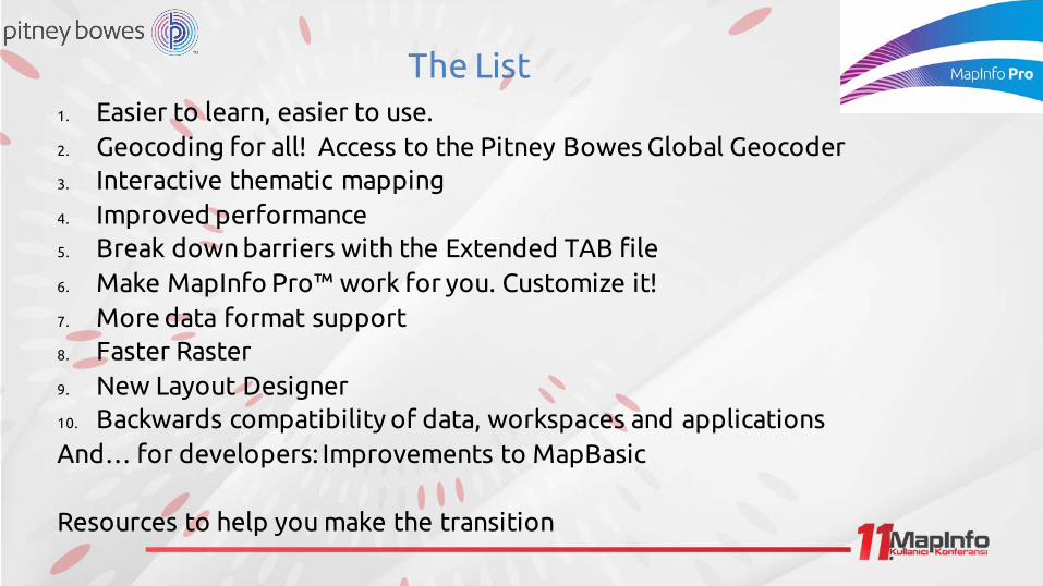
The List1. Easier to learn, easier to use. 2. Geocoding for all! Access to the Pitney Bowes Global Geocoder3. Interactive thematic mapping4. Improved performance5. Break down barriers with the Extended TAB file6. Make MapInfo Pro™ work for you. Customize it!7. More data format support8. Faster Raster9. New Layout Designer10. Backwards compatibility of data, workspaces and applicationsAnd… for developers: Improvements to MapBasic
Resources to help you make the transition
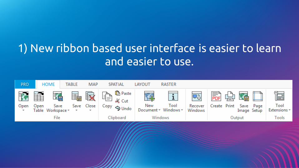
1) New ribbon based user interface is easier to learn and easier to use.
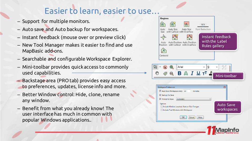
Easier to learn, easier to use…– Support for multiple monitors.
– Auto save and Auto backup for workspaces.
– Instant feedback (mouse over or preview click)
– New Tool Manager makes it easier to find and use MapBasic add-ons.
– Searchable and configurable Workspace Explorer.
– Mini-toolbar provides quick access to commonly used capabilities.
– Backstage area (PRO tab) provides easy access to preferences, updates, license info and more.
– Better Window control: Hide, clone, rename any window.
– Benefit from what you already know! The user interface has much in common with popular Windows applications..
Instant feedback with the Label Rules gallery
Mini-toolbar
Auto Save workspaces
2) Geocoding for all!
Get your data on the map with the Pitney Bowes Global Geocoder

Geocoding for all!Starting in MapInfo Pro v16.0 every MapInfo Pro user can access the Pitney Bowes online Global Geocoder.
Requires signing up for an account.
1000 credits per month (per user)
– City/postal level geocode = 1 credit per geocode– Street level (or better) = 5 credits per geocode
Premium Services customers receive 2000 credits per month (per user)
Upgrade plans available for those who require additional geocoding.
Easy to sign up and you get a monthly allocation of credits
for as long as MapInfo Pro is maintained.

3) Interactive Thematic Mapping
See it faster, solve it sooner!

New Interactive Thematic Mapping
More easily visualise and analyse data with the new Theme ribbon tab
Interactive ranges now appear in the layers list
Change thematic map settings interactively Change the
column being mapped with a couple of clicks
New colorpalettes
4) Performance Improvements
Get more done in less time!
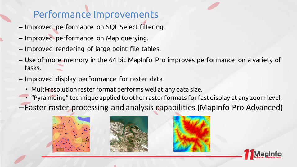
Performance Improvements– Improved performance on SQL Select filtering.
– Improved performance on Map querying.
– Improved rendering of large point file tables.
– Use of more memory in the 64 bit MapInfo Pro improves performance on a variety of tasks.
– Improved display performance for raster data
• Multi-resolution raster format performs well at any data size.• “Pyramiding” technique applied to other raster formats for fast display at any zoom level.
–Fasterrasterprocessingandanalysiscapabilities(MapInfoProAdvanced)
5) Breaking down barriers with the new Extended TAB file format
Have large data files? Is that 2 GB file size limit getting in your way?
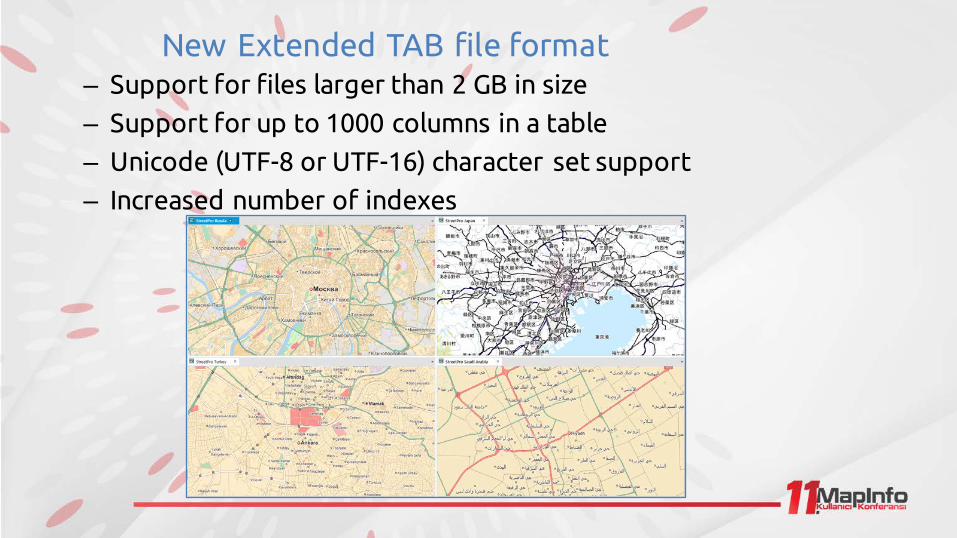
New Extended TAB file format– Support for files larger than 2 GB in size
– Support for up to 1000 columns in a table
– Unicode (UTF-8 or UTF-16) character set support
– Increased number of indexes
6) Make MapInfo Pro work for you: Customize it!
No programming required !

Customize the interface to suit your needs
– Customizable Quick Access Toolbar– Customizable Ribbon (add your own Ribbon Tabs
and/or Groups)– Create your own keyboard shortcuts. Assign any
command to any key combination.
– Preferences to configure the Workspace Explorer, window behaviour and lots more.
– New Tool Manager – easier to manage yourtools and add-ins. TheQuickAccess
Toolbar
7) Support for more data formats
Get access to the data you need!Share data more easily!
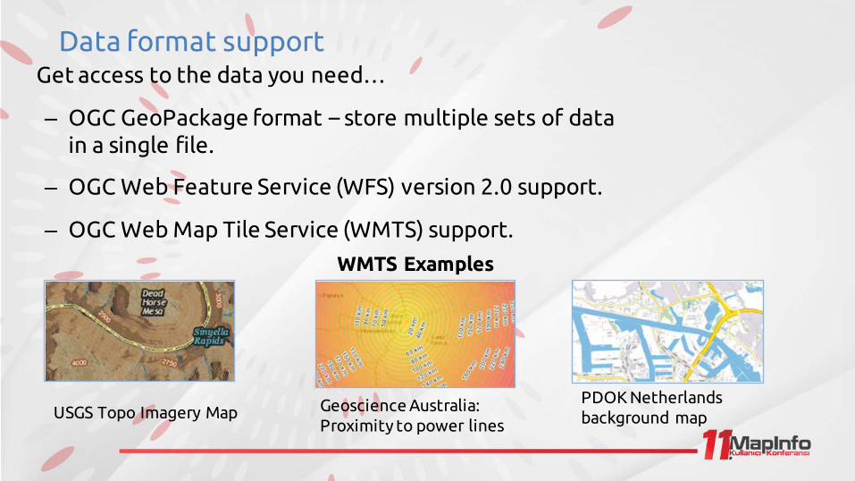
Data format supportGet access to the data you need…
– OGC GeoPackage format – store multiple sets of data in a single file.
– OGC Web Feature Service (WFS) version 2.0 support.
– OGC Web Map Tile Service (WMTS) support.
USGS Topo Imagery Map Geoscience Australia: Proximity to power lines
PDOK Netherlands background map
WMTS Examples
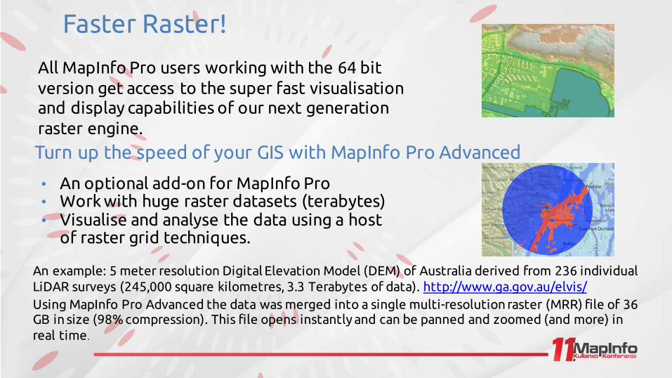
8) Faster Raster!
Great display and visualisation with raster data of virtually any size!Take your analysis to the next level with MapInfo Pro Advanced
Faster Raster!
All MapInfo Pro users working with the 64 bit version get access to the super fast visualisation and display capabilities of our next generation raster engine.
Turn up the speed of your GIS with MapInfo Pro Advanced
• An optional add-on for MapInfo Pro• Work with huge raster datasets (terabytes)• Visualise and analyse the data using a host
of raster grid techniques.
An example: 5 meter resolution Digital Elevation Model (DEM) of Australia derived from 236 individual LiDAR surveys (245,000 square kilometres, 3.3 Terabytes of data). http://www.ga.gov.au/elvis/Using MapInfo Pro Advanced the data was merged into a single multi-resolution raster (MRR) file of 36 GB in size (98% compression). This file opens instantly and can be panned and zoomed (and more) in real time.
9) New Layout Designer
Prepare your maps for output more quickly and easily

New Layout Designer– No more switching back and forth between your Map and Layout – work
directly on Layout canvas.– New graticule (dynamic or static).
– Grids and guidelines for easy alignment.– Better support for using images.
– Layout is WYSIWYG.
– Scale bars directly on Layout page.
10) Backwards compatibility
Bring your existing maps and data into the 64 bit version
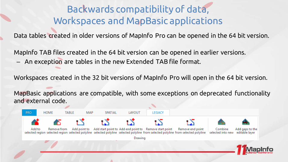
Backwards compatibility of data, Workspaces and MapBasic applications
Data tables created in older versions of MapInfo Pro can be opened in the 64 bit version.
MapInfo TAB files created in the 64 bit version can be opened in earlier versions. – An exception are tables in the new Extended TAB file format.
Workspaces created in the 32 bit versions of MapInfo Pro will open in the 64 bit version.
MapBasic applications are compatible, with some exceptions on deprecated functionality and external code.
For Developers: Improvements to MapBasic
Create better applications for your users than ever before!

MapBasic window – easier to learn and use
MapBasic window syntax highlighting and preferences.MapBasic language improvements
– MapBasic .NET support enhanced • Construct objects
• Call Instance and Interface Methods and Properties
– New variable types: This, RefPtr, IntPtr and LargeInt,
– New interface is encompassed in a Microsoft .NET object model.
• Support for .NET Instance object and Interface Properties and Methods
• NET object model can be used from compiled MapBasic
– Improved method for integrating maps in other applications.
Resources to help you make the transition
There is plenty of help for you out there!
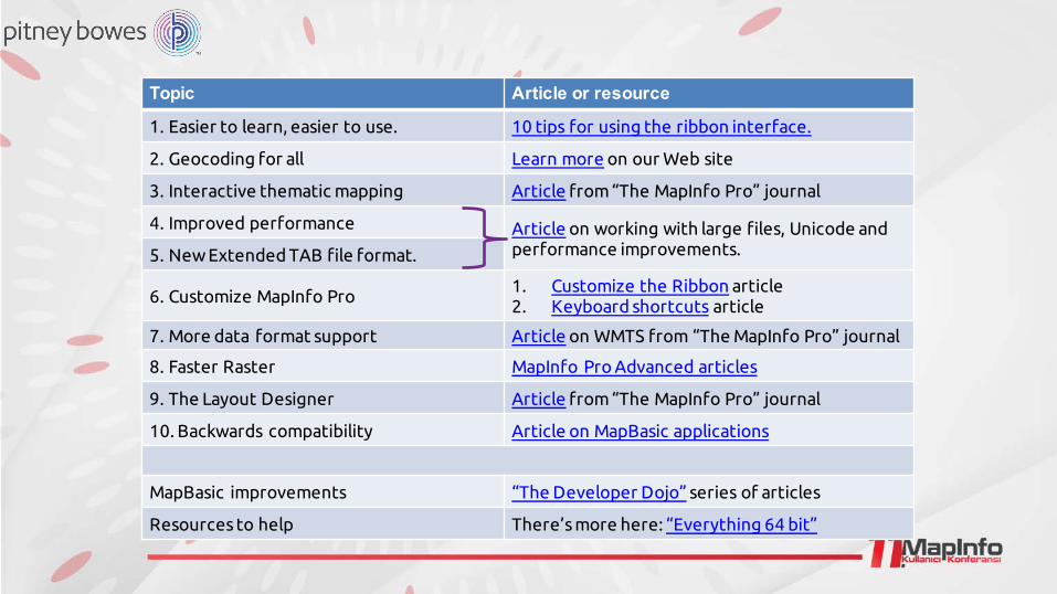
Want to know more?
Topic Article or resource
1. Easier to learn, easier to use. 10 tips for using the ribbon interface.
2. Geocoding for all Learn more on our Web site
3. Interactive thematic mapping Article from “The MapInfo Pro” journal
4. Improved performance Article on working with large files, Unicode and performance improvements.5. New Extended TAB file format.
6. Customize MapInfo Pro1. Customize the Ribbon article2. Keyboard shortcuts article
7. More data format support Article on WMTS from “The MapInfo Pro” journal
8. Faster Raster MapInfo Pro Advanced articles
9. The Layout Designer Article from “The MapInfo Pro” journal
10. Backwards compatibility Article on MapBasic applications
MapBasic improvements “The Developer Dojo” series of articles
Resources to help There’s more here: “Everything 64 bit”

Want to know more?Don't have MapInfo Pro™ v16.0 yet?
Download it from our Web site here:
http://www.pitneybowes.com/us/mipro-free-trial.html
For more tips, tricks, techniques and advice, why not sign up for "The MapInfo Pro" monthly journal?

Tom ProbertMapInfo Pro Global Product [email protected]


