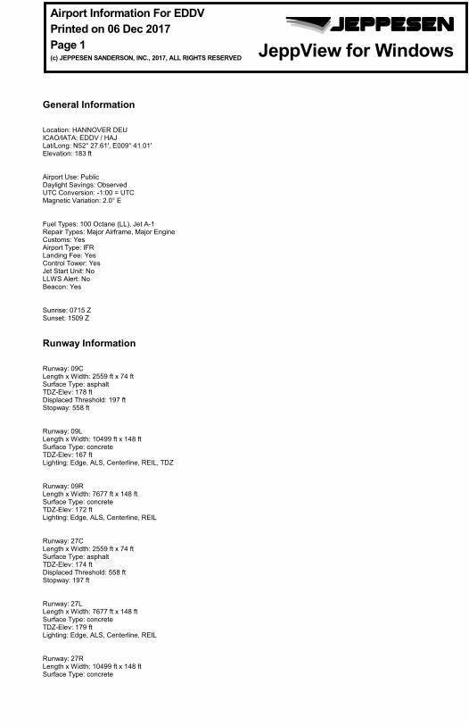
General Information Location: HANNOVER DEU ICAO/IATA: EDDV / HAJ Lat/Long: N52° 27.61', E009° 41.01' Elevation: 183 ft Airport Use: Public Daylight Savings: Observed UTC Conversion: -1:00 = UTC Magnetic Variation: 2.0° E Fuel Types: 100 Octane (LL), Jet A-1 Repair Types: Major Airframe, Major Engine Customs: Yes Airport Type: IFR Landing Fee: Yes Control Tower: Yes Jet Start Unit: No LLWS Alert: No Beacon: Yes Sunrise: 0715 Z Sunset: 1509 Z Runway Information Runway: 09C Length x Width: 2559 ft x 74 ft Surface Type: asphalt TDZ-Elev: 178 ft Displaced Threshold: 197 ft Stopway: 558 ft Runway: 09L Length x Width: 10499 ft x 148 ft Surface Type: concrete TDZ-Elev: 167 ft Lighting: Edge, ALS, Centerline, REIL, TDZ Runway: 09R Length x Width: 7677 ft x 148 ft Surface Type: concrete TDZ-Elev: 172 ft Lighting: Edge, ALS, Centerline, REIL Runway: 27C Length x Width: 2559 ft x 74 ft Surface Type: asphalt TDZ-Elev: 174 ft Displaced Threshold: 558 ft Stopway: 197 ft Runway: 27L Length x Width: 7677 ft x 148 ft Surface Type: concrete TDZ-Elev: 179 ft Lighting: Edge, ALS, Centerline, REIL Runway: 27R Length x Width: 10499 ft x 148 ft Surface Type: concrete TDZ-Elev: 169 ft Lighting: Edge, ALS, Centerline, REIL, TDZ Communication Information ATIS: 136.575 At or below 33574432 ft Out to 60 mi. Hannover Tower: 37.495 Military Hannover Tower: 120.175 Hannover Tower: 120.400 Hannover Ground: 121.950 De-Icing Ramp/Taxi: 130.600 De-Icing Ramp/Taxi: 121.600 Secondary Bremen Radar ACC: 25.972 Military Bremen Radar ACC: 131.325 Bremen Radar ACC: 119.600 General Information Location: HANNOVER DEU ICAO/IATA: EDDV / HAJ Lat/Long: N52° 27.61', E009° 41.01' Elevation: 183 ft Airport Use: Public Daylight Savings: Observed UTC Conversion: -1:00 = UTC Magnetic Variation: 2.0° E Fuel Types: 100 Octane (LL), Jet A-1 Repair Types: Major Airframe, Major Engine Customs: Yes Airport Type: IFR Landing Fee: Yes Control Tower: Yes Jet Start Unit: No LLWS Alert: No Beacon: Yes Sunrise: 0715 Z Sunset: 1509 Z Runway Information Runway: 09C Length x Width: 2559 ft x 74 ft Surface Type: asphalt TDZ-Elev: 178 ft Displaced Threshold: 197 ft Stopway: 558 ft Runway: 09L Length x Width: 10499 ft x 148 ft Surface Type: concrete TDZ-Elev: 167 ft Lighting: Edge, ALS, Centerline, REIL, TDZ Runway: 09R Length x Width: 7677 ft x 148 ft Surface Type: concrete TDZ-Elev: 172 ft Lighting: Edge, ALS, Centerline, REIL Runway: 27C Length x Width: 2559 ft x 74 ft Surface Type: asphalt TDZ-Elev: 174 ft Displaced Threshold: 558 ft Stopway: 197 ft Runway: 27L Length x Width: 7677 ft x 148 ft Surface Type: concrete TDZ-Elev: 179 ft Lighting: Edge, ALS, Centerline, REIL Runway: 27R Length x Width: 10499 ft x 148 ft Surface Type: concrete Airport Information For EDDV Printed on 06 Dec 2017 Page 1 (c) JEPPESEN SANDERSON, INC., 2017, ALL RIGHTS RESERVED j e p JEPPESEN JeppView for Windows
ATIS: 136.575 At or below 33574432 ft Out to 60 mi.Hannover Tower: 37.495 MilitaryHannover Tower: 120.175Hannover Tower: 120.400Hannover Ground: 121.950De-Icing Ramp/Taxi: 130.600De-Icing Ramp/Taxi: 121.600 SecondaryBremen Radar ACC: 25.972 MilitaryBremen Radar ACC: 131.325Bremen Radar ACC: 119.600
Airport Information For EDDVPrinted on 06 Dec 2017Page 2(c) JEPPESEN SANDERSON, INC., 2017, ALL RIGHTS RESERVED
jep=JEPPESENJeppView for Windows
| JEPPESEN, 2005, 2011. ALL RIGHTS RESERVED.
HANNOVER, GERMANYEDDV/HAJHANNOVER
JEPPESEN+
AIRPORT.BRIEFING
1.1. ATIS*D-ATIS 136.57
1.2. NOISE ABATEMENT PROCEDURES1.2.1. NIGHT FLYING RESTRICTIONS
Between 2200-0559LT, aircraft exceeding the noise limits pursuant to ICAO Annex 16, Volume 1, Chapter 3 are not permitted to operate.If any ACFT are to take-off or land between 2300-0559LT, a copy of the noise certificates shall be submitted in advance.Between 2300-0559LT, only the following ACFT movements and ACFT are permitted:1. Take-offs and landings of turbo-jet ACFT with noise certificate in accordance
ICAO with Annex 16, Chapter 3 or 4 which are more than 8 EPNdB below the limits laid down in ICAO Annex 16, Volume 1, Chapter 3, anda) which are usually scheduled for the APT of Hannover, orb) which are used for night airmail service of a universal service provider as defined in the Postal Universal Service Ordinance (PUDLV) if the night flight is required to meet the quality standard in accordance with Article 2, item 3 of the PUDLV (service provider shall prove this in advance to the airport), orc) which are operated by air carriers whose main base and maintenance facilities are in Hannover.
2. Take-offs and landings of turbo-jet cargo ACFT with noise certificate in accordance ICAO with Annex 16, Chapter 3 or 4, anda) which are more than 8 EPNdB below the limits laid down in ICAO Annex 16, Volume 1, Chapter 3, orb) all jet ACFT up to 25000 KGS MTOW which are more than 5 EPNdB below the limits laid down in ICAO Annex 16, Volume 1, Chapter 3, as well as the following ACFT types:A300 CANADAIR RJA310 DASH 8-400A319 FOKKER 70/100A320 GULFSTREAM IV/VA321 LOCKHEED L1011 - take-off onlyA330 DC 8-70 - seriesA340 DC 10 - take-off onlyBAe 146/AVRO RJ-series DC 10-30 (all versions) - landing onlyB717 MD 11B727-100 re-engined with 3 tay engines MD 80 (all versions) - landing onlyB737-300/400/500/600/700/800 MD 90B747-400 TUPOLEV 204B757 B767B777
3. Landings of ACFT not exceeding the limits pursuant to ICAO Annex 16, Volume 1, Chapter 3, operated by air carriers whose main base and maintenance facilities are in Hannover.
4. Take-offs and landings of ACFT with different means of propulsion in commercial and corporate air traffic complying with the provisions of ICAO Annex 16, Volume 1, Chapters 3, 4, 5, 6, (-4 dBA), 8, 10 (-3 to -8 dBA) or 11 and/or Chapters III, IV 2.4, VII or X 2.4 of Noise Requirements for ACFT as well as landings of ACFT with different means of propulsion and noise certificate stationed at Hannover Airport in business air traffic.
5. Landings of delayed ACFT which are part of scheduled air services or regular air inclusive tours, which do not exceed the noise limits pursuant to ICAO Annex 16, Volume 1, Chapter 3 and which are scheduled to arrive at Hannover prior to 2300LT.
6. Landings of ACFT provably using the airport as alternate aerodrome for meteorological, technical or other safety reasons.
10-1P19 AUG 11
1. GENERAL
Printed from JeppView for Windows 5.3.0.0 on 06 Dec 2017; Terminal chart data cycle 24-2017; Notice: After 14 Dec 2017, 0000Z, this chart may no longer be valid
| JEPPESEN, 2005, 2011. ALL RIGHTS RESERVED.
HANNOVER, GERMANYEDDV/HAJHANNOVER
JEPPESEN+
AIRPORT.BRIEFING
7. Calibration flights conducted by DFS Deutsche Flugsicherung GmbH as far as necessary for maintaining flight safety.
8. Take-offs and landings in emergency cases.9. Take-offs and landings in exceptional cases with special permission from the
aviation supervision office of the "Niedersaechsisches Ministerium fuer Wirtschaft, Arbeit und Verkehr".
Subject to further restrictions of this provision, between 2200-0559LT take-offs and landings by ACFT as listed below are only permitted on the northern RWYs 09L/27R. Exceptions for urgent technical, meteorological or operational reasons are possible.A300 LOCKHEED L1011A310 DC 8-70-seriesA330 DC 10A340 MD 11B727-100 re-engined with 3 tay engines MD 80-seriesB737-200 MD 90B747-400 TUPOLEV 154B757-300 TUPOLEV 204B767 B777andpropeller-driven ACFT with more than 5.7t MTOW.
1.2.2. LOCAL FLYING RESTRICTIONS1. Arrivals and departures immediately following one another as well as circling
flights for ACFT over 5.7t MTOW and for ACFT up to 5.7t MTOW not complying with the conditions of ICAO Annex 16, Volume I, Chapter 3, 4, 5, 6 (-4 dB [A]), 8, 10 (-3 to -8 dB [A]) or 11 pursuant to ICAO and/or LSL Chapters III, V, VI 2.4, VIII or X 2.4: Only permitted MON-FRI between 0600-2059LT and SAT between 0800-1259LT.
2. Arrivals and departures immediately following one another as well as circling flights for ACFT up to 5.7t MTOW complying with the conditions of ICAO Annex 16, Volume I, Chapter 3, 4, 5, 6 (-4 dB [A]), 8, 10 (-3 to -8 dB [A]) or 11 pursuant to ICAO and/or LSL Chapters III, V, VI 2.4, VIII or X 2.4: Only permitted MON-SAT between 0600-2059LT and SUN, HOL between0800-2059LT.
3. Arrivals and departures immediately following one another, not represented at the APT by an ACFT operator, are subject to permission by the "Luftaufsicht" at Hannover APT.
1.2.3. RUN-UP TESTSRun-up tests of jet engines shall be conducted exclusively in a noise suppression facility which is ready for operation.If the noise suppression facility is not ready for operation, run-up tests of jet engines may be conducted only from 0600-2200LT. Between 2200-2400LT as well as between 0400-0600LT run-up tests of jet engines may, however, also be conducted outside the noise suppression facility which is not ready for operation if required for urgent maintenance due to safety reasons shortly before a take-off after landing. This provision does not apply to idle test runs.
1.3. LOW VISIBILITY PROCEDURES ACFT will be guided onto RWY by Follow-me car.Enquiries via HANNOVER Ground.
10-1P119 AUG 11
1. GENERAL
Printed from JeppView for Windows 5.3.0.0 on 06 Dec 2017; Terminal chart data cycle 24-2017; Notice: After 14 Dec 2017, 0000Z, this chart may no longer be valid
1.4. AUXILIARY POWER UNIT (APU)To avoid additional noise and reduce further immissions, utilization of the APUshall be reduced to a minimum. This is the responsibility of the pilot.The APU shall be operated only:- To start the engines; 15 min prior to EOBT; at the earliest;- For necessary maintenance work on the ACFT;- If the stationary or mobile ground equipment of the APT is not available or
suitable for certain ACFT types.In special cases, extended hours of operation for the APU may be granted by theAPT duty officer (Tel : +49 511 977 1455).
1.5. TAXI PROCEDURES1.5.1. GENERAL
During the entire taxiing phase, ACFT shall maintain continuous radio contactwith the control tower. Any instructions to change frequency shall be compliedwith without delay.To increase safety of RWYs RWY guard lights have been installed on both sides ofCAT I holding positions of RWYs 09L/27R and 09R/27L, as well as of holding posi-tions of RWY 09C/27C.On the apron, ACFT are permitted to taxi only at the minimum RPM required.TWYs A1, D1, F1 and L1 on the apron are ACFT stand taxilanes with reduced min-imum separation distances between taxilane centerlines and stationary objects.The separation distances between taxilane centerline and the red obstacle limita-tion lines are:- 156'/47.5m in the area of the parallel TWY F1 between positions 42 and 61 and
L1 between postitions 4 an 27. The separation between the parallel guidelinesis 256'/78m.
- 139'/42.5m in the area of TWY D1.- 136'/41.5m in the area of taxilane A1 between positions 23 and 42.- 125'/38m in the area of positions 1 and 2.- 85'/26m in the area of positions 12, 13 and 20.When entering positions 1 to 20, the oversteering procedure shall be used.TWY B MAX wingspan 118'/36m, 59'/18m wheel base.TWY P MAX wingspan 56'/17m.TWY O MAX wingspan 66'/20m.TWY Q MAX wingspan 118’/36m.While taxiing to and from RWY 09L/27R pilots will need crossing-clearance forRWY 09C/27C, which is an active VFR daytime RWY. To avoid RWY incursionspilots are referred to the published hot spots on 10-9 page.
1.5.2. OPERATION OF B747-8/8F:- B747-8/8F may only take off from and land on RWY 09L/27R.- Taxiing on TWYs and the apron is only permitted under the guidance of a Fol-
low-me car.The following TWYs shall be used:- To enter RWY 27R: TWY L and TWY M;- To enter RWY 09L: TWY L and TWY G;- To exit RWY 27R: TWY H, TWY G and TWY L or TWY G and TWY L;- To exit RWY 09L: TWY M and TWY L.B747-8/8F shall be parked on stand DP1 or 61.
1.6. PARKING INFORMATION1.6.1. GENERAL
On stands 1 thru 28 and 40 thru 61, except R-stands push-back required.Stands 1 thru 20, except A-stands equipped with visual docking guidance system.For stand graphic refer to 10-9 charts.
10-1P222 SEP 17
1. GENERAL
| JEPPESEN, 2005, 2017. ALL RIGHTS RESERVED.
Printed from JeppView for Windows 5.3.0.0 on 06 Dec 2017; Terminal chart data cycle 24-2017; Notice: After 14 Dec 2017, 0000Z, this chart may no longer be valid
TWY B not available for A320, A321 and DH8D ACFT.A318 and A319 ACFT are not allowed to enter RWY 09R/27L via TWY B.
1.6.2. GENERAL AVIATION 1All ACFT will be guided by Follow-me.MAX wingspan 66'/20m between hangar 11, 12 and posn 72-75.MAX wingspan 56'/17m in front of hangar 13.MAX wingspan 52'/16m on other parts of apron.
1.6.3. GENERAL AVIATION 2MAX wingspan 49'/15m.
1.6.4. GENERAL AVIATION 3MAX wingspan 118’/36m; ACFT with wingspan over 95’/29m will be towed.
Between 2100-0600LT reverse thrust, other than idle thrust, shall only be used toan extent necessary for safety reasons.
2.2. CAT II/III OPERATIONSRWY 09L/27R approved for CAT II/III operations, special aircrew and ACFT certi-fication required.
2.3. OTHER INFORMATION2.3.1. FUEL SAVING AND NOISE REDUCING ILS APPROACH PROCEDURES
(CONTINOUS DESCENT APPROACH - CDA)
2.3.1.1. GENERALFor the purpose of fuel-saving and noise abatement during approach the followingapproach procedure is announced. It may be requested by the pilot or offered bythe controller. It can be conducted only in connection with an ILS approach.
2.3.1.2. PROCEDUREACFT will be guided by the approach control unit by means of radar vectoring andwill be cleared for a continuous descent to the intermediate approach altitude insuch a way that after reaching this intermediate approach altitude on the local-izer course, about 1NM will be left for intercepting the glide path in level flight.This intermediate approach segment will serve to reduce speed. Intermediate approach altitude: 2000'. It is assumed that the continuous descentwill be performed at a rate of 300ft/NM (descent angle approx 3^), down to thecleared altitude.If, for specific reasons (e.g. separation, airspace structure, obstacles), altitudesabove the intermediate approach altitude have to be initially assigned, theserestrictions will be lifted early enough to allow a continuous descent at a rate of300ft/NM.Details about the distance from touchdown will be transmitted to the pilottogether with the clearance for descent and usually at 20, 15 and 10NM fromtouchdown. This should enable the pilot to correct the rate of descent as required.In case of traffic situations allowing no CDA (e.g. approaches of ACFT with dif-ferent performance data), pilots will be informed by the notice NO CDAPOSSIBLE. In this case, approaches must be conducted according to the previousprocedures.
2.3.1.3. NOISE ABATEMENTOn approaches in accordance with the CDA, pilots are also expected to use theapproach techniques recommended for noise abatement in the vicinity of APTs(see AIR TRAFFIC CONTROL page GERMANY-1).
2. ARRIVAL
10-1P322 SEP 17
1. GENERAL
| JEPPESEN, 2005, 2017. ALL RIGHTS RESERVED.
Printed from JeppView for Windows 5.3.0.0 on 06 Dec 2017; Terminal chart data cycle 24-2017; Notice: After 14 Dec 2017, 0000Z, this chart may no longer be valid
The de-icing of ACFT will take place on defined de-icing areas (DPs), exclusively.These areas are located at the Western part of the apron.De-icing on other parking positions - with the exception of the regulationdescribed below - is not permitted.
3.1.2. DE-ICING AREASThe special areas assigned for the de-icing of ACFT are designated DP1 and DP2(see 10-9A). In exceptional cases, de-icing may take place on the positionslocated in between. The actual de-icing position will be assigned by the de-icingoperator. The de-icing of jet-propelled ACFT will be carried out with runningengines and switched off auxiliary power units (APU). The same regulationapplies for ACFT types ATR 42/72 with applied propeller brakes.
3.1.3. DE-ICINGA de-icing operation shall be reported to the de-icing operator in good time (30 min in advance prior to OFB/CTOT) under the phone number (0511)-9771415however, when obtaining start-up clearance for the engines on frequency 121.95, at the least.The order of notifications has no influence on the actual de-icing sequence. Thiswill be determined by ground control, exclusively.After start-up clearance/push-back, ACFT will be guided by ground control to theimmediate vicinity of the de-icing areas. The ACFT will then be guided by a Fol-low-me car to a vacant de-icing position.After parking the ACFT on the de-icing area, the pilot will report on HANNOVERDe-icing 130.6 together with his flight number. After the de-icing process hasbeen completed, the pilot-in-command shall report "ready to taxi" to HANNOVERGround.If the engines have to be started up again, this shall be reported to groundcontrol.During the de-icing process, the pilot shall maintain constant listening watch onthe respective de-icing frequency. When the de-icing procedure has been com-pleted, the de-icing code will be transmitted and the ACFT handed over by the de-icing operator to the ground controller.Taxiing manoeuvres from the de-icing areas may only be carried out after expressclearance by the ground controller and with the absolute minimum number ofengine revolutions required, only.After de-icing has taken place, the de-icing areas shall be vacated as quickly aspossible after receiving taxi clearance.All special services, such as the de-icing of the undercarriage or de-icing beneaththe wings, will be conducted on the pads with engines switched off, only.The hands-on check will generally only be carried out by representatives of theair transport company concerned or by a crew member of the de-iced ACFT on therespective de-icing pad. A hands-on check shall be requested by the crew througha handling agent, only. On instructions from the de-icing operator, an ACFT maybe towed to another position for the hands-on check or planned for another de-icing position in the pre-planning stage already. If a hands-on check becomes nec-essary, the control tower shall be informed in time, but at the latest whenrequesting startup clearance. The employees of FHG and AGS (de-icing personnel)will not carry out these checks.Differences of the above or in published Aeroplane Deicing Plan mentioned proce-dures have to be granted by the airport operator.
10-1P430 JUN 17
3. DEPARTURE
| JEPPESEN, 2005, 2015. ALL RIGHTS RESERVED.
Printed from JeppView for Windows 5.3.0.0 on 06 Dec 2017; Terminal chart data cycle 24-2017; Notice: After 14 Dec 2017, 0000Z, this chart may no longer be valid
3.2. TAXI PROCEDURESACFT may leave nose-in positions only by the aid of ACFT tractors.Reverse thrust or variable pitch propellers shall not be used.
3.3. NOISE ABATEMENT PROCEDURESThe starting points for the take-off runs of 3200m in length are located at thelevel of the eastern edge of TWY N for landing direction 27 and at the level of thewestern edge of TWY H for landing direction 09. The starting points located 300min front of THR 09L for take-offs in an eastern direction and 300m in front of THR27R for take-offs in a western direction may only be used by ACFT requiring atake-off run exceeding 3200m for the forthcoming take-off.
Pilots shall obtain start-up approval on the appropriate frequency of GROUND.
3.4.2. PUSH-BACK PROCEDURE ON MAIN APRON (STANDS 1 THRU 61)To receive push-back instructions from nose-in position, pilots are requested tocontact the "Walkout Assistent" after they received approval to start theirengines.This request shall only be made if the pilot is able to carry out the manoeuvrewithout delay. The "Walkout Assistent" will carry out the push-back procedureimmediately after receiving the necessary clearance from apron control. To avoiddelays, the engines shall be started during push-back.
3.4.3. TAXI PROCEDURETo obtain taxi-out instructions after push-back or from a roll-out stand, pilots areinstructed to request taxi clearance on the appropriate frequency of GROUND.
3.5. OTHER INFORMATION3.5.1. DATALINK DEPARTURE CLEARANCE (DCL)
Temporal parameters:ti 25 min prior to EOBT for unregulated flights.
30 min prior to CTOT for ATFM regulated flights.tt 11 min prior to EOBT for unregulated flights.
16 min prior to CTOT for ATFM regulated flights.t1 5 min.
10-1P530 JUN 17
3. DEPARTURE
| JEPPESEN, 2005, 2017. ALL RIGHTS RESERVED.
Printed from JeppView for Windows 5.3.0.0 on 06 Dec 2017; Terminal chart data cycle 24-2017; Notice: After 14 Dec 2017, 0000Z, this chart may no longer be valid
JEPPESEN
2
21
40NM
80NM
80NM
40NM
80NM
160NM
120NM
120NM
120NM
Hannover
Alt Set: hPa (IN on request) Trans level: By ATC Trans alt: 5000'
2000(2100)
2500(2800)
ALTITUDENOT PUBLISHED
LANG
EN
EDG
GFIR
MUN
ICH
EDM
M FIR
BREMENEDWW FIR
The MRVA (Minimum Radar Vectoring Altitude) is the lowest altitude which may be used for radar vectors for IFR flights taking into ac-count the minimum safe height (1000' above the highest obstacle with-in a radius of 8 km) and airspace structure (lower limit of the con-trolled airspace plus a buffer of 500'). Below the MRVA, IFR flights will normally be cleared on published IFR procedures only.Altitudes in brackets apply between AIRAC date NOV and AIRAC dateMAR in order to meet required obstacle clearance at cold temperatures.
Printed from JeppView for Windows 5.3.0.0 on 06 Dec 2017; Terminal chart data cycle 24-2017; Notice: After 14 Dec 2017, 0000Z, this chart may no longer be valid
D28
D23
266^D23
R187
^
244^ HLZ117
.3
hlz
D
088^
268^
4000
GITEX
4000
19
301^
R121^
EDDV/HAJ.STAR.HANNOVER
HANNOVER, GERMANY
RWYS 27L/R ARRIVALS
RWYS 09L/R ARRIVALS
Apt Elev Alt Set: hPa (IN on request)183' Trans level: By ATC Trans alt: 5000'
D ELN
AT 2
R
3
ELNAT
3 Between ELNAT & NORTABRNAV equipment necessary.
1 BRNAV equipment necessary.
*D-ATIS
1
340^
070^
2800'
2100'
MSA HW NDBwithin 15 NM
HANNOVER358 HWHW
N52 28.1 E009 32.8
136.575
JEPPESEN
.Eff.2.Feb.
2
4
2 Only for flights with requested FLabove FL245.
(D34 WRB)
GITEX 4R
48.45000
285^
GITEX 4P7000
8.9
(117.3 HLZ R-203/D24)
27 JAN 17
ELNAT 4P [ELNA4P] , GITEX 4P [GITE4P]
2ELNAT 2R [ELNA2R] , GITEX 4R [GITE4R] 1
4
10-2
3
| JEPPESEN, 2017. ALL RIGHTS RESERVED.Chart reindexed; procedures renumbered & revised; coordinates.
NIE116.5 NIENIENBURG
N52 37.6 E009 22.3
CEL311 CELCELLE
N52 35.4 E010 01.8
DLE115.2 DLELEINE
N52 15.0 E009 53.0
(IAF Rwys 27L/R)
CHANGES:
WRB113.7 WRBWARBURG
N51 30.4 E009 06.7
18
4000
5000
5000
5000
R185
^
004^
345^
NORTA
343^
5000
NOT TO SCALE
(IAF Rwys 09L/R)ROBEG
TOLTA
29.8
ELN
AT 4
P
24.1
005^
ELNAT 4P, GITEX 4P:
VERTICAL PLANNINGINFORMATION
Pilots should plan for possible descentclearance as follows:
at or below FL80 by DLE.
at or below FL80 by ROBEG.
SPEED RESTRICTION
or as by ATC.Not applicable within airspace C.
MAX 250 KT below FL100
ACTUAL DESCENT CLEARANCEAS DIRECTED BY ATC.
D8.9DLE
5.0
D5.0 DLE
34.0
CAUTIONIntensive glider activities to be expectedin the surrounding area of CEL.
4000
187^
007^
(WRB R-006/D44.0)
ELNAT 2R, GITEX 4R:
WERRA
5000
16.0
Printed from JeppView for Windows 5.3.0.0 on 06 Dec 2017; Terminal chart data cycle 24-2017; Notice: After 14 Dec 2017, 0000Z, this chart may no longer be valid
COMMSLOST
COMMS
LOST
COMMS LOST
COMMS
LOST
COMMS
LOST
COMMS
LOST
COMMS
LOST
COMMS
LOST
D
4000181^
001^
EDDV/HAJ.STAR.HANNOVER
HANNOVER, GERMANY10-2A
Apt Elev Alt Set: hPa (IN on request)183' Trans level: By ATC Trans alt: 5000'
*D-ATIS
HANNOVER
358
HW
HW
N52
28.1
E009
32.8
340^07
0^
2800
'2100
'
MSA
HW
ND
Bw
ithi
n 15
NM
136.575
JEPPESEN
2
2
.Eff.2.Feb.
0 93^
27 JAN 17
HEHLINGEN 6P (HLZ 6P)
HEHLINGEN 6R (HLZ 6R)
RWYS 27L/R ARRIVAL
RWYS 09L/R ARRIVAL
| JEPPESEN, 2017. ALL RIGHTS RESERVED.Chart reindexed; STARs renumbered; OSN STARs withdrawn.
4000
273^
077^
257^
NIE
116.5
NIE
NIENBU
RG
N52
37.6
E009
22.3
24
4000
CEL
311
CEL
CELLE
N52
35.4
E010
01.8
HL
Z11
7.3
HLZ
HEH
LINGEN
N52
21.8
E010
47.7
31
4000
294^
(IA
F Rw
ys 0
9L/R
)
(IA
F Rw
ys 2
7L/R
)
NO
T TO
SCA
LE
1
CHANGES:
HLZ
6R
In c
ase
of r
adio
com
mun
icat
ion
1N
IE.
fail
ure
proc
eed
to:
HLZ
6R:
HLZ
6R:
Cle
ara
nce l
imit
is C
EL.
VERTIC
AL
PLA
NNIN
G INFO
RM
ATIO
NPi
lots
sho
uld
plan
for
pos
sibl
e de
scen
t cl
eara
nce
as f
ollo
ws:
ACTUA
L DESCENT C
LEA
RA
NCE A
S D
IRECTED B
Y A
TC.
HLZ
6P:
HLZ
6R:
at o
r be
low
FL1
10 b
y CEL
.at
or
belo
w F
L80
by N
IE.
SPEED R
ESTRIC
TIO
N
or a
s by
ATC
.N
ot a
ppli
cabl
e w
ithi
n ai
rspa
ce C
.
MA
X 2
50 K
T be
low
FL1
00
CA
UTIO
NIn
tens
ive
glid
er a
ctiv
itie
s to
be
expe
cted
in t
he s
urro
undi
ng a
rea
of C
EL.
at o
r be
low
FL7
0 by
CEL
.at
or
belo
w F
L120
by
HLZ
,
HLZ
6P, 6R
Printed from JeppView for Windows 5.3.0.0 on 06 Dec 2017; Terminal chart data cycle 24-2017; Notice: After 14 Dec 2017, 0000Z, this chart may no longer be valid
D
266^D23
D
D36
R187
^
088^4000
268^
007^
EDDV/HAJHANNOVER
HANNOVER, GERMANY10-2B
D
D
.STAR.Apt Elev Alt Set: hPa (IN on request)183' Trans level: By ATC Trans alt: 5000'
*D-ATIS
HANNOVER
358 HWHWN52 28.1 E009 32.8
340^
070^
2800'
2100'
MSA HW NDBwithin 15 NM
136.575
JEPPESEN
.Eff.2.Feb.27 JAN 17
CELLE
311 CELCELN52 35.4 E010 01.8
RWYS 27L/R ARRIVAL
RWYS 09L/R ARRIVAL
1
| JEPPESEN, 2017. ALL RIGHTS RESERVED.Chart reindexed; STARs renumbered & withdrawn; coordinates.
1
WRB113.7 WRBWARBURG
N51 30.4 E009 06.7
30
4000
5000
R210^
UMKUK
030^
006^
1750
00
5000
WRB
7P
WRB 5
R
44
4000
ROBEG
CHANGES:
(IAF Rwys 09L/R)
NIE116.5 NIENIENBURG
N52 37.6 E009 22.3
DLE115.2 DLELEINE
N52 15.0 E009 53.0
(IAF Rwys 27L/R)
NOT TO SCALE
VERTICAL PLANNING INFORMATION
WRB 7P:WRB 5R:
Pilots should plan for possible descent clearanceas follows:
at or below FL80 by DLE.at or below FL80 by ROBEG.
SPEED RESTRICTION
or as by ATC.Not applicable within airspace C.
MAX 250 KT below FL100
ACTUAL DESCENT CLEARANCE ASDIRECTED BY ATC.
D6.0 DLE
6.0
WARBURG 7P (WRB 7P)
WARBURG 5R (WRB 5R)
CAUTIONIntensive glider activities to be expectedin the surrounding area of CEL.
Printed from JeppView for Windows 5.3.0.0 on 06 Dec 2017; Terminal chart data cycle 24-2017; Notice: After 14 Dec 2017, 0000Z, this chart may no longer be valid
D23
266^D23
D44
006^
R187
^
D
088^
268^
4000
EDDV/HAJ.STAR.HANNOVER
HANNOVER, GERMANY
Apt Elev Alt Set: hPa (IN on request)183' Trans level: By ATC Trans alt: 5000'
10-2C
D
187^
3
3 Between WERRA & NORTABRNAV equipment necessary.
1 BRNAV equipment necessary.
*D-ATIS
1
340^
070^
2800'
2100'
MSA HW NDBwithin 15 NM
HANNOVER358 HWHW
N52 28.1 E009 32.8
136.575
JEPPESEN
4
.Eff.2.Feb.
4
2 Only for flights with requested FLbelow FL245.
(D34 WRB)
RWYS 27L/R ARRIVAL
RWYS 09L/R ARRIVAL
WERRA
325^
WERRA
2R
5000
15.5
2
2
27 JAN 17
WERRA 2R [WERA2R]
WERRA 1P [WERA1P]
Chart reindexed; STAR WERRA 1R renumbered 2R; coordinates. | JEPPESEN, 2017. ALL RIGHTS RESERVED.
NIE116.5 NIENIENBURG
N52 37.6 E009 22.3
CEL311 CELCELLE
N52 35.4 E010 01.8
DLE115.2 DLELEINE
N52 15.0 E009 53.0
(IAF Rwys 27L/R)
CHANGES:
WRB113.7 WRBWARBURG
N51 30.4 E009 06.7
18
4000
5000
5000
R185
^
005^
007^
NORTA
343^
5000
4000
NOT TO SCALE
(IAF Rwys 09L/R)ROBEG
TOLTA
WERRA
1P
24.1
WERRA 2R:
VERTICAL PLANNINGINFORMATION
Pilots should plan for possible descentclearance as follows:
at or below FL80 by DLE.
at or below FL80 by ROBEG.
SPEED RESTRICTION
or as by ATC.Not applicable within airspace C.
MAX 250 KT below FL100CAUTIONIntensive glider activities to be expectedin the surrounding area of CEL.
ACTUAL DESCENT CLEARANCEAS DIRECTED BY ATC.
WERRA 1P:
5.0
34.0
D5.0 DLE
Printed from JeppView for Windows 5.3.0.0 on 06 Dec 2017; Terminal chart data cycle 24-2017; Notice: After 14 Dec 2017, 0000Z, this chart may no longer be valid
COMMS
LOST
COMMS
LOST
COMMS
LOST
COMMS
LOST
COMMS
LOST
COMMS
LOST
COMMS
LOST
COMMS
LOST
LOST
COMMSCO
MMS
COMMS
LOST
LOST
COMMS LOST
COMMSLOST
EDDV/HAJHANNOVER
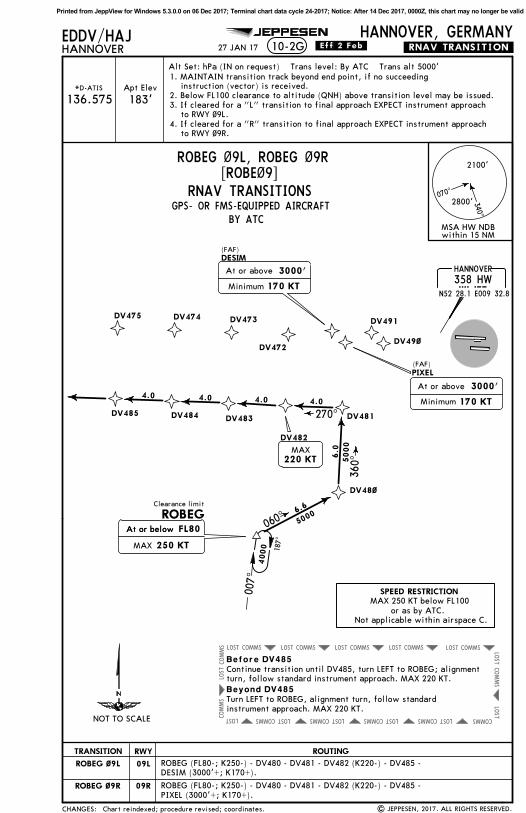
HANNOVER, GERMANY10-2D .RNAV.TRANSITION.
TRA
NSIT
ION
09L
CEL
09L
Alt Set: hPa (IN on request) Trans level: By ATC Trans alt 5000'
CEL
09R
09R
09L
NIE
09L
NIE
09R
09R
270^
DV
465
DV
46~
DV
463
DV
464
DV
461
DV
462
DV
4~~
PIX
EL
DESIM
DV
472
DV
475
DV
474
DV
473
DV
491
DV
49~
4000181^
001^
CELLE
311
CEL
CEL
N52
35.4
E010
01.8
090^
NIE
~9L,
~9R
260^
180^
CEL
~9L,
~9R
17.6
6.9
4.4
5000
5000
5000
5000
220 K
TM
AX
CEL
~9L
, ~9
R
At
or b
elow 250 K
T
FL1
10
At
or b
elow
FL1
10
250 K
TM
AX
GPS- OR FMS-EQUIPPED AIRCRAFTBY ATC
RNAV TRANSITIONS
340^
070^
2800
'2100
'
MSA
HW
ND
Bw
ithi
n 15
NM
HANNOVER
358
HW
HW
N52
28.1
E009
32.8
JEPPESEN
.Eff.2.Feb.
Chart reindexed; procedures revised; coordinates.
4.0
4.0
4.0
4.0
4.0
(FA
F)
(FA
F)
1
27 JAN 17
At
or b
elow
250 K
TM
AX
At
or b
elow
FL8
0
*D-ATIS
136.575Apt Elev
183'
Before D
V465
Beyond D
V465
Min
imum
170 K
T
3000'
At
or a
bove
Min
imum
170 K
T
3000'
At
or a
bove2
20 K
TM
AX
Turn
RIG
HT
to N
IE,
alig
nmen
t tu
rn,
foll
ow s
tand
ard
inst
rum
ent
appr
oach
. M
AX 2
20 K
T.
Con
tinu
e tr
ansi
tion
unt
il D
V46
5, t
urn
RIG
HT
to N
IE;
alig
nmen
ttu
rn,
foll
ow s
tand
ard
inst
rum
ent
appr
oach
. M
AX 2
20 K
T.
NIE
(FL
80-;
K25
0-)
- D
V40
0 (K
220-
) -
DV46
0 -
DV46
5 -
PIXEL
(30
00'+
; K17
0+).
NIE
(FL
80-;
K25
0-)
- D
V40
0 (K
220-
) -
DV46
0 -
DV46
5 -
DES
IM (
3000
'+;
K17
0+).
CEL
(FL
110-
; K25
0-)
- D
V46
0 (K
220-
) -
DV46
5 -
PIXEL
(30
00'+
; K17
0+).
CEL
(FL
110-
; K25
0-)
- D
V46
0 (K
220-
) -
DV46
5 -
DES
IM (
3000
'+;
K17
0+).
| JEPPESEN, 2017. ALL RIGHTS RESERVED.
1. MAINTAIN transition track beyond end point, if no suceeding instruction (vector) is received.2. Below FL100 clearance to altitude (QNH) above transition level may be issued.3. If cleared for a "L" transition to final approach EXPECT instrument approach to RWY ~9L.4. If cleared for a "R" transition to final approach EXPECT instrument approach to RWY ~9R.
CEL ~9L, CEL ~9R[CEL~9]
NIE ~9L, NIE ~9R[NIE~9]4
000
NO
T TO
SCA
LE
CHANGES:
RW
YRO
UTIN
G
NIE
116.5
NIE
NIENBU
RG
N52
37.6
E009
22.3
Cle
aran
ce l
imit
Cle
aran
ce l
imit
257^
077^
SPEED R
ESTRIC
TIO
N
or a
s by
ATC
.N
ot a
ppli
cabl
e w
ithi
n ai
rspa
ce C
.
MA
X 2
50 K
T be
low
FL1
00
CA
UTIO
NIn
tens
ive
glid
er a
ctiv
itie
s to
be
expe
cted
in t
he s
urro
undi
ng a
rea
of C
EL.
1
Printed from JeppView for Windows 5.3.0.0 on 06 Dec 2017; Terminal chart data cycle 24-2017; Notice: After 14 Dec 2017, 0000Z, this chart may no longer be valid
COMMS
LOST
COMMS
LOST
COMMS
LOST
COMMS
LOST
COMMS
LOST
COMMS
LOST
COMMS
LOST
COMMS
LOST
LOST
COMMS
COMMS
COMMS
LOST
LOST
COMMS LOST
COMMSLOST
GPS- OR FMS-EQUIPPED AIRCRAFT
EDDV/HAJHANNOVER
HANNOVER, GERMANY10-2E .RNAV.TRANSITION.
BY ATC
TRA
NSIT
ION
27L
CEL
27L
Alt Set: hPa (IN on request) Trans level: By ATC Trans alt 5000'
CEL
27R
27R
27L
NIE
27L
NIE
27R
27R
ODIN
I
XA
VER
DV
591
DV
575
DV
572
DV
573
DV
574
DV
59~
DV
5~~
DV
5~1
DV
5~2
DV
565
DV
564
DV
563
DV
562
DV
561
DV
56~
4000181^
001^
CELLE
311
CEL
CEL
N52
35.4
E010
01.8
180^A
t or
bel
ow 250 K
T
220 K
TM
AX
6.9
14.2
NIE
27L,
27R
5000
5000
090^
108^
271^
285^
220 K
TM
AX
220 K
TM
AX
NIE
27L
, 27
R
1
Min
imum
170 K
T
3000'
3000'
At
or a
bove
Min
imum
170 K
T
3000'
3000'
At
or a
bove
1
FL7
0
At
or b
elow 250 K
TM
AX
FL1
10
At
or b
elow 250 K
TM
AX
JEPPESEN
340^
070^
2800
'2100
'
MSA
HW
ND
Bw
ithi
n 15
NM
HANNOVER
358
HW
HW
N52
28.1
E009
32.8
.Eff.2.Feb.
Chart reindexed; procedures revised; coordinates.
2
CEL
27L,
27R
5000
4.0
5.0
5.0
3.0
(FA
F)
(FA
F)
4.0
4.0
4.0
4.0
27 JAN 17
091^
Before D
V565
Beyond D
V565
Con
tinu
e tr
ansi
tion
unt
il D
V56
5, t
urn
LEFT
to
CEL
; al
ignm
ent
turn
, fo
llow
sta
ndar
d in
stru
men
t ap
proa
ch.
MA
X 2
20 K
T.
Turn
LEF
T to
CEL
, al
ignm
ent
turn
, fo
llow
sta
ndar
din
stru
men
t ap
proa
ch.
MA
X 2
20 K
T.
Apt Elev
183'*D-ATIS
136.575
Min
imum
170 K
T
3000'
At
or a
bove
RNAV TRANSITIONS
| JEPPESEN, 2017. ALL RIGHTS RESERVED.
NIE
(FL
110-
; K25
0-)
- D
V50
2 (K
220-
) -
DV56
5 -
XA
VER
(30
00'+
; K17
0+).
NIE
(FL
110-
; K25
0-)
- D
V50
2 (K
220-
) -
DV56
5 -
OD
INI
(300
0'+
; K17
0+).
CEL
(FL
70-;
K25
0-)
- D
V50
0 -
DV50
1 (K
220-
) -
DV50
2 -
DV56
5 -
XA
VER
(30
00'+
; K17
0+).
CEL
(FL
70-;
K25
0-)
- D
V50
0 -
DV50
1 (K
220-
) -
DV50
2 -
DV56
5 -
OD
INI
(300
0'+
; K17
0+).
CEL 27L, CEL 27R[CEL27]
NIE 27L, NIE 27R[NIE27]
1. MAINTAIN transition track beyond end point, if no succeeding instruction (vector) is received.2. Below FL 100 clearance to altitude (QNH) above transition level may be issued.3. If cleared for a "L" transition to final approach EXPECT instrument approach to RWY 27L.4. If cleared for a "R" transition to final approach EXPECT instrument approach to RWY 27R.
4000
NO
T TO
SCA
LE
CHANGES:
RW
YRO
UTIN
G
NIE
116.5
NIE
NIENBU
RG
N52
37.6
E009
22.3
Cle
aran
ce l
imit
Cle
aran
ce l
imit
257^
077^
SPEED R
ESTRIC
TIO
N
or a
s by
ATC
.N
ot a
ppli
cabl
e w
ithi
n ai
rspa
ce C
.
MA
X 2
50 K
T be
low
FL1
00
CA
UTIO
N
2
Inte
nsiv
e gl
ider
act
ivit
ies
to b
e ex
pect
ed i
n th
e su
rrou
ndin
g ar
ea o
f CEL
.
Printed from JeppView for Windows 5.3.0.0 on 06 Dec 2017; Terminal chart data cycle 24-2017; Notice: After 14 Dec 2017, 0000Z, this chart may no longer be valid
COMMSLOST COMMSLOST COMMSLOST COMMSLOST
COMMS LOSTCOMMS LOSTCOMMS LOSTCOMMS LOSTLOSTCOMMS
COMMSLOST
LOST
LOST
COMMS
COMMS
COMMS
LOST
ODINI
XAVER
DV591
GPS- OR FMS-EQUIPPED AIRCRAFT
EDDV/HAJHANNOVER
HANNOVER, GERMANY10-2F .RNAV.TRANSITION.
BY ATC
TRANSITION
27LDLE 27L
RNAV TRANSITIONS
Alt Set: hPa (IN on request) Trans level: By ATC Trans alt 5000'
DLE 27R 27R
DV585
DV575DV572 DV573 DV574
DV582
DV581
DV583
DV59~
LEINE115.2 DLEDLE
N52 15.0 E009 53.0
D
088^
268^
DV584
220 KT
At or below
250 KTMAX
At or below FL80
5.6
7.3
001^
091^
5000
5000
220 KTMAX
JEPPESEN
HANNOVER
358 HWHWN52 28.1 E009 32.8
340^
070^
2800'
2100'
MSA HW NDBwithin 15 NM
.Eff.2.Feb.
Chart reindexed; procedures revised; coordinates.
(FAF)
(FAF)
4.0 4.0 4.0
27 JAN 17
Apt Elev
183'*D-ATIS
136.575
Before DV585
Beyond DV585
Continue transition until DV585, turn RIGHT to DLE; alignmentturn, follow standard instrument approach. MAX 220 KT.
Turn RIGHT to DLE, alignment turn, follow standardinstrument approach. MAX 220 KT.
Minimum 170 KT
3000'At or above
Minimum 170 KT
3000'At or above
1. MAINTAIN transition track beyond end point, if no succeeding instruction (vector) is received.2. Below FL100 clearance to altitude (QNH) above transition level may be issued.3. If cleared for a "L" transition to final approach EXPECT instrument approach to RWY 27L.4. If cleared for a "R" transition to final approach EXPECT instrument approach to RWY 27R.
Printed from JeppView for Windows 5.3.0.0 on 06 Dec 2017; Terminal chart data cycle 24-2017; Notice: After 14 Dec 2017, 0000Z, this chart may no longer be valid
Alt Set: hPa (IN on request) Trans level: By ATC Trans alt 5000'
09R
ROBEG
PIXEL
DESIM
ROBEG ~9L
ROBEG ~9R
DV472
DV475 DV474 DV473 DV491
DV49~
DV48~
DV481
DV482
DV485DV483DV484
5000
5000
6.6
060^
360^
270^
220 KTMAX
At or below
250 KTMAX
At or below FL80
340^
070^
2800'
2100'
MSA HW NDBwithin 15 NM
JEPPESEN
HANNOVER
358 HWHWN52 28.1 E009 32.8
.Eff.2.Feb.
(FAF)
(FAF)
4.0 4.0 4.0 4.0
6.0
27 JAN 17
Minimum 170 KT
3000'At or above
Minimum 170 KT
3000'At or above
Before DV485
Beyond DV485
Continue transition until DV485, turn LEFT to ROBEG; alignmentturn, follow standard instrument approach. MAX 220 KT.
Turn LEFT to ROBEG, alignment turn, follow standardinstrument approach. MAX 220 KT.
Apt Elev
183'*D-ATIS
136.575
Chart reindexed; procedure revised; coordinates.
1. MAINTAIN transition track beyond end point, if no succeeding instruction (vector) is received.2. Below FL100 clearance to altitude (QNH) above transition level may be issued.3. If cleared for a "L" transition to final approach EXPECT instrument approach to RWY ~9L.4. If cleared for a "R" transition to final approach EXPECT instrument approach to RWY ~9R.
Printed from JeppView for Windows 5.3.0.0 on 06 Dec 2017; Terminal chart data cycle 24-2017; Notice: After 14 Dec 2017, 0000Z, this chart may no longer be valid
GPS- OR FMS-EQUIPPED AIRCRAFT
EDDV/HAJHANNOVER
HANNOVER, GERMANY10-2H .RNAV.TRANSITION.
Apt Elev
183'
Alt Set: hPa (IN on request) Trans level: By ATC Trans alt 5000'
JEPPESEN
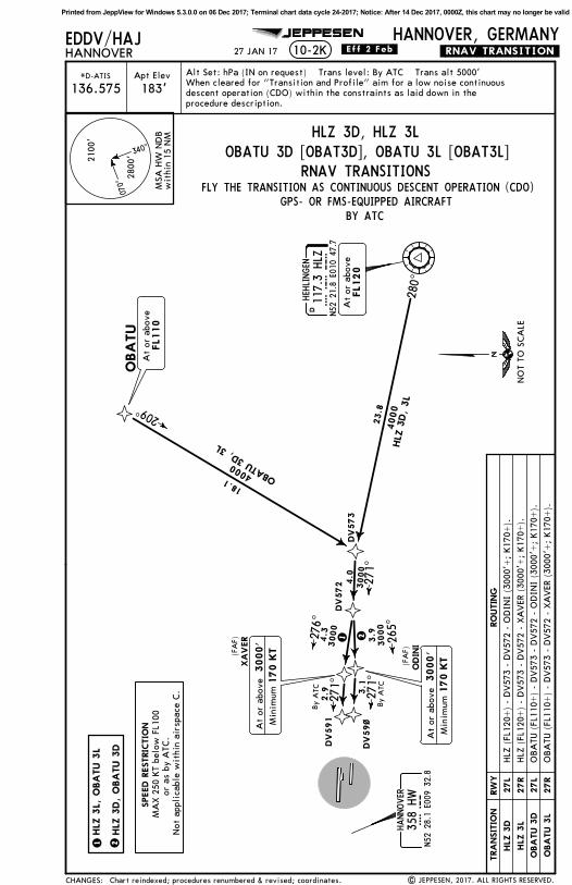
FLY THE TRANSITION AS CONTINUOUS DESCENT OPERATION (CDO)
TRANSITION
09L
09R
09L
09R
OBATU 3A
OBATU 3E
ESTAD 3A
ESTAD 3E
DESIMPIXEL
DV49~
3
1
2
3000'
Minimum 170 KT
At or above
340^
070^
2800'
2100'
MSA HW NDBwithin 15 NM
136.575
.Eff.2.Feb.
(FAF)(FAF)
When cleared for "Transition and Profile" aim for a low noise continuousdescent operation (CDO) within the constraints as laid down in theprocedure description.
27 JAN 17
ESTAD 3A [ESTA3A], ESTAD 3E [ESTA3E]OBATU 3A [OBAT3A], OBATU 3E [OBAT3E]
Printed from JeppView for Windows 5.3.0.0 on 06 Dec 2017; Terminal chart data cycle 24-2017; Notice: After 14 Dec 2017, 0000Z, this chart may no longer be valid
EDDV/HAJHANNOVER
HANNOVER, GERMANY10-2J .RNAV.TRANSITION.
BY ATC
TRA
NSIT
ION
09L
Alt Set: hPa (IN on request) Trans level: By ATC Trans alt 5000'
09R
JEPPESEN
340^
070^
2800
'2100
'
MSA
HW
ND
Bw
ithi
n 15
NM
.Eff.2.Feb.27 JAN 17
Apt Elev
183'*D-ATIS
136.575
RNAV TRANSITIONSDV
462
DV
472
DV
49~
DV
491
DV
563
HEH
LINGEN
117.3
HLZ
HL
ZN52
21.8
E010
47.7
D
HLZ
1A
HLZ
1E
HLZ 1A, HLZ 1E
When cleared for "Transition and Profile" aim for a low noise continuousdescent operation (CDO) within the constraints as laid down in theprocedure description.
292^
271^
4000
4000
25.0
30.6
5.03000180^
DESIM
3
3000'
Min
imum
170 K
T
At
or a
bove
(FA
F)
3.1
1
3000
083^
4.0
096^2
3000
2.7
090^
By
ATC 2.7
090^
By
ATC
1 2
3
HLZ
1A
HLZ
1E
PIX
EL
(FA
F)
3000'
Min
imum
170 K
T
At
or a
bove
HLZ
1A, 1E
FLY THE TRANSITIONAS CONTINUOUS
DESCENT OPERATION(CDO)
GPS- OR FMS-EQUIPPED AIRCRAFT
| JEPPESEN, 2017. ALL RIGHTS RESERVED.STARs transferred; RNAV transitions established.
HLZ
- D
V56
3 -
DV46
2 -
DV47
2 -
DES
IM (
3000
'+;
K17
0+).
HLZ
- D
V56
3 -
DV46
2 -
DV47
2 -
PIXEL
(30
00'+
; K17
0+).
NO
T TO
SCA
LE
CHANGES:
RW
YRO
UTIN
G
SPEED R
ESTRIC
TIO
N
or a
s by
ATC
.N
ot a
ppli
cabl
e w
ithi
n ai
rspa
ce C
.
MA
X 2
50 K
T be
low
FL1
00
Printed from JeppView for Windows 5.3.0.0 on 06 Dec 2017; Terminal chart data cycle 24-2017; Notice: After 14 Dec 2017, 0000Z, this chart may no longer be valid
GPS- OR FMS-EQUIPPED AIRCRAFT
EDDV/HAJHANNOVER
HANNOVER, GERMANY10-2K .RNAV.TRANSITION.
Apt Elev
183'Alt Set: hPa (IN on request) Trans level: By ATC Trans alt 5000'
JEPPESEN
280^
271^
23.8
HLZ
3D,
3L
4.0
4.3
3.9
3000
3000
276^
265^
XA
VER
ODIN
I
DV
572
DV
573
OBA
TU
DHEH
LINGEN
117.3
HLZ
HL
ZN52
21.8
E010
47.7
DV
591
DV
59~
2.9 3
.127
1^
271^
FLY THE TRANSITION AS CONTINUOUS DESCENT OPERATION (CDO)
When cleared for "Transition and Profile" aim for a low noise continuousdescent operation (CDO) within the constraints as laid down in theprocedure description.
TRA
NSIT
ION
27L
HLZ
3D
HLZ
3L
27R
27L
27R
OBA
TU 3
D
OBA
TU 3
L
HLZ 3D, HLZ 3L
1 2
21
3000'
Min
imum
170 K
T
At
or a
bove
340^
070^
2800
'2100
'
MSA
HW
ND
Bw
ithi
n 15
NM
136.575
By
ATC
By
ATC
HANNOVER
358
HW
HW
N52
28.1
E009
32.8
.Eff.2.Feb.
(FA
F)(FA
F)
27 JAN 17
HLZ
3L,
OBA
TU 3
L HLZ
3D,
OBA
TU 3
D
OBATU 3D [OBAT3D], OBATU 3L [OBAT3L]RNAV TRANSITIONS
209^
18.1 OBA
TU 3
D, 3L
FL1
10
At
or a
bove
FL1
20
At
or a
bove
3000'
Min
imum
170 K
TA
t or
abo
ve
4000
4000
HLZ
(FL
120+
) -
DV57
3 -
DV57
2 -
OD
INI
(300
0'+
; K17
0+).
HLZ
(FL
120+
) -
DV57
3 -
DV57
2 -
XA
VER
(30
00'+
; K17
0+).
OBA
TU (
FL11
0+)
- D
V57
3 -
DV57
2 -
OD
INI
(300
0'+
; K17
0+).
OBA
TU (
FL11
0+)
- D
V57
3 -
DV57
2 -
XA
VER
(30
00'+
; K17
0+).
3000
*D-ATIS
BY ATC
| JEPPESEN, 2017. ALL RIGHTS RESERVED.Chart reindexed; procedures renumbered & revised; coordinates.CHANGES:
RW
YRO
UTIN
G
NO
T TO
SCA
LE
MA
X 2
50 K
T be
low
FL1
00or
as
by A
TC.
Not
app
lica
ble
wit
hin
airs
pace
C.
SPEED R
ESTRIC
TIO
N
Printed from JeppView for Windows 5.3.0.0 on 06 Dec 2017; Terminal chart data cycle 24-2017; Notice: After 14 Dec 2017, 0000Z, this chart may no longer be valid
GPS- OR FMS-EQUIPPED AIRCRAFT
EDDV/HAJHANNOVER
HANNOVER, GERMANY10-2L .RNAV.TRANSITION.
Apt Elev
183'
Alt Set: hPa (IN on request) Trans level: By ATC Trans alt 5000'
JEPPESEN
FLY THE TRANSITION AS CONTINUOUS DESCENT OPERATION (CDO)
WRB 3A, WRB 3E
TRANSITION
TOLTA 3A
TOLTA 3E
09L
09R
09L
09R
WRB 3A
WRB 3E
09L
09R
KUGAV 3A
KUGAV 3E
KUGAV
DV473
DV483
360^080^
22.7
KUGAV 3A, 3E
5.0
9.6
ROBEG
346^343^
002^
34.0
53.3
WRB 3
A,
3E
TO
LTA
3A
, 3E
TOLTA
D113.7 WRBWRB
N51 30.4 E009 06.7
WARBURG
DV472
DESIM
PIXEL
4.0
090^
3.1
4.0
096^
083^
DV49~
DV491
2.7090^
2.7090^
1
2
3000
3000
HANNOVER
358 HWHWN52 28.1 E009 32.8
340^
070^
2800'
2100'
MSA HW NDBwithin 15 NM
136.575
By ATC
By ATC
.Eff.2.Feb.
(FAF)
(FAF)
When cleared for "Transition and Profile" aim for a low noise continuousdescent operation (CDO) within the constraints as laid down in theprocedure description.
27 JAN 17
KUGAV 3A [KUGA3A], KUGAV 3E [KUGA3E]TOLTA 3A [TOLT3A], TOLTA 3E [TOLT3E]
3000'
Minimum 170 KTAt or above
3000'Minimum 170 KT
At or above
1
2
RNAV TRANSITIONS
KUGAV 3A, TOLTA 3A,WRB 3AKUGAV 3E, TOLTA 3E,WRB 3E
| JEPPESEN, 2017. ALL RIGHTS RESERVED.Chart reindexed; procedures renumbered & revised; coordinates.
4000
CHANGES:
RWY ROUTING
MAX 250 KT below FL100or as by ATC.
Not applicable within airspace C.
SPEED RESTRICTION
NOT TO SCALE
Printed from JeppView for Windows 5.3.0.0 on 06 Dec 2017; Terminal chart data cycle 24-2017; Notice: After 14 Dec 2017, 0000Z, this chart may no longer be valid
GPS- OR FMS-EQUIPPED AIRCRAFT
EDDV/HAJHANNOVER
HANNOVER, GERMANY10-2M .RNAV.TRANSITION.
Apt Elev
183'Alt Set: hPa (IN on request) Trans level: By ATC Trans alt 5000'
JEPPESEN
VIS
KI
090^
354^
181^
271^
50.0
21.2
VIS
KI 3D,
3L
5.0
4.0
4.3
3.9
3000
3000
276^
265^
XA
VER
ODIN
I
DV
572
DV
563
UPDA
T
DV
591
DV
59~
2.9 3.1
271^
271^
FLY THE TRANSITION AS CONTINUOUS DESCENT OPERATION (CDO)
When cleared for "Transition and Profile" aim for a low noise continuousdescent operation (CDO) within the constraints as laid down in theprocedure description.
TRA
NSIT
ION
27L
27R
UPDA
T 3
D
UPDA
T 3
L
27L
27R
VIS
KI 3D
VIS
KI 3L
21
340^
070^
2800
'2100
'
MSA
HW
ND
Bw
ithi
n 15
NM
136.575
By
ATC
By
ATC
HANNOVER
358
HW
HW
N52
28.1
E009
32.8
.Eff.2.Feb.
| JEPPESEN, 2017. ALL RIGHTS RESERVED.
(FA
F)
(FA
F)
27 JAN 17
UPDAT 3D [UPDA3D], UPDAT 3L [UPDA3L]VISKI 3D [VISK3D], VISKI 3L [VISK3L]
Printed from JeppView for Windows 5.3.0.0 on 06 Dec 2017; Terminal chart data cycle 24-2017; Notice: After 14 Dec 2017, 0000Z, this chart may no longer be valid
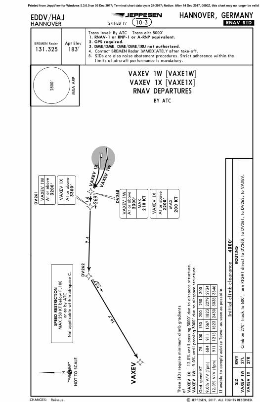
Trans level: By ATC Trans alt: 5000'
EDDV/HAJHANNOVER
HANNOVER, GERMANY
Contact BREMEN Radar IMMEDIATELY after take-off.
JEPPESEN
24 FEB 17
VA
XEV
DV
262
DV
261
DV
26~
1.6
7.4
10.7
269^
237^
VA
XEV 1
XVAXEV
1W
2800
'
MSA
ARP
VA
XEV
1X:
If u
nabl
e to
com
ply
advi
se T
ower
as
soon
as
poss
bile
.
10-3
BY ATC
Init
ial
clim
b cl
eara
nce
4000'
RNAV DEPARTURES
.RNAV.SID.
1. RNAV-1 or RNP-1 or A-RNP equivalent.2. GPS required.3. DME/DME, DME/DME/IRU not authorized.
Apt Elev
183'BREMEN Radar
131.325SIDs are also noise abatement procedures. Strict adherence within thelimits of aircraft performance is mandatory.
VA
XEV
1W
:
VAXEV 1W [VAXE1W]VAXEV 1X [VAXE1X]
Thes
e SI
Ds
requ
ire
min
imum
cli
mb
grad
ient
sof
200 K
T
VA
XEV
1X
At
or a
bove
2200'
MA
X
VA
XEV
1W
At
or a
bove
2300'
210 K
TM
AXV
AXEV
1W
At
or a
bove
3200'
VA
XEV
1X
At
or a
bove
3300'
12.0
% u
ntil
pas
sing
300
0' d
ue t
o ai
rspa
ce s
truc
ture
.9.
0% u
ntil
pas
sing
300
0' d
ue t
o ai
rspa
ce s
truc
ture
.
12.0
% V
/V (
fpm
)91
112
1518
2324
3030
3836
46
9.0%
V/V
(fp
m)
684
911
1367
1823
2279
2734
Gnd
spe
ed-K
T75
100
150
200
250
300
Cim
b on
270
^ tr
ack
to 6
00',
tur
n RI
GHT
dire
ct t
o D
V26
~, t
o D
V26
1, t
o D
V26
2, t
o VA
XEV
.RW
YSID
RO
UTIN
G
27R
27L
CHANGES:
5.4.
NO
T TO
SCA
LE
| JEPPESEN, 2017. ALL RIGHTS RESERVED.
VA
XEV
1X
VA
XEV
1W
SPEED R
ESTRIC
TIO
N
or a
s by
ATC
.N
ot a
ppli
cabl
e w
ithi
n ai
rspa
ce C
.
MA
X 2
50 K
T be
low
FL1
00
Reissue.
Printed from JeppView for Windows 5.3.0.0 on 06 Dec 2017; Terminal chart data cycle 24-2017; Notice: After 14 Dec 2017, 0000Z, this chart may no longer be valid
R134^R135^
118^
CEL8F
HBD0.5 DME
SIDs are also noise abatement procedures. Strict adherence withinthe limits of aircraft performance is mandatory.
D7.5 HADD8.8 HBD
HAD2.0 DME
DME
314^
357^
087^
CEL 6Y
CEL 9G
4
DME
D4.2 HBD
090^
Apt Elev
183'BREMEN Radar
Trans level: By ATC Trans alt: 5000'
EDDV/HAJHANNOVER
HANNOVER, GERMANY
Contact BREMEN Radar IMMEDIATELY after take-off.
D5.2 HAD
315^ 023^
Initial climb clearance 4000'
270^090^270^ 091^
4
131.325
HBD 8.4DME
HANNOVER
358 HWHW
340^
070^
2800'
2100'
within 15 NMMSA HW Lctr
.Eff.2.Feb.
1
CEL 8F:
CEL 6S:
1
1 After passing NIE R-118 B-RNAV equipment necessary.
DMEHAD 7.2
These SIDs require minimum climb gradients
.SID.
JEPPESEN
D4.0 HADD5.4 HBD
CEL 6S
HAD 2.0 DME
At
or 600'whichever is later
HBD 0.5 DME/HAD 2.0 DME
At
or 600'whichever is later
HAD 2.0 DME/NIE R-132
(NIE R-132)
D
(201^ BRG to HW)
If unable to comply advise Tower as soon as possible.
Climb straight ahead to 0.5 DME WEST of HBD/HAD 2.0 DME or 600', whicheveris later, turn RIGHT, intercept NIE R-135 inbound to D4.2 HBD/201^ bearingto HW, turn RIGHT, 357^ track, when passing NIE R-118 turn RIGHT,intercept 087^ bearing to CEL.
Climb straight ahead to HBD 8.4 DME/HAD 7.2 DME, turn LEFT, intercept 023^bearing to CEL.
D
of550' per NM (9.0%) until passing 3500'due to airspace structure.730' per NM (12.0%) until passing 4000'due to airspace structure.
Climb straight ahead to D7.5 HAD/D8.8 HBO, turn LEFT, intercept 023^ bearing to CEL.
Climb straight ahead to HAD 2.0 DME/NIE R-132 or 600', whichever is later, turnRIGHT, intercept NIE R-134 inbound to D5.2 HAD/D4.5 HBD, turn RIGHT, 357^ track, when passing NIE R-118 turn RIGHT, intercept 087^ bearing to CEL.
D4.5 HBD
730' per NM 913 1217 1825 2433 3042 3650
550' per NM 688 917 1375 1833 2292 2750
Gnd speed-KT 75 100 150 200 250 300
CEL 8F 27L
CEL 9G 09R
CEL 6S 27R
09LCEL 6Y
HANNOVER
HAD(113.95) HAD
HANNOVER
HBD(116.9) HBD
CHANGES:
2.1.
RWYSID ROUTING
HA320 HAHANNOVER
CEL311 CELCELLE
NIE116.5 NIENIENBURG
MAX 250 KT below FL100or as by ATC.
Not applicable within airspace C.
SPEED RESTRICTION
NOT TO SCALE
N52 28.1 E009 41.7
N52 27.3 E009 39.6
N52 37.6 E009 22.3
N52 27.8 E009 48.3
N52 35.4 E010 01.8
SIDs renumbered & revised; coordinates; chart reindexed. | JEPPESEN, 2017. ALL RIGHTS RESERVED.
Printed from JeppView for Windows 5.3.0.0 on 06 Dec 2017; Terminal chart data cycle 24-2017; Notice: After 14 Dec 2017, 0000Z, this chart may no longer be valid
D10 R2
85^
R134^
R135^
118^
D29
MULD
O 5
Y
MULD
O 6
GM
ULD
O
105^
8
090^
MUL
DO
8F
.SID.
Apt Elev
183'BREMEN Radar
Trans level: By ATC Trans alt: 5000'
EDDV/HAJHANNOVER
HANNOVER, GERMANY
Contact BREMEN Radar IMMEDIATELY after take-off.
DM
E
10-3C
DM
E
315^
D4.2
HBD
314^
357^
D5.2
HA
D
4000
To H
A,
turn
RIG
HT,
094
^ be
arin
g to
MULD
O.
Init
ial
clim
b cl
eara
nce
4000'
HBD
0.5
DME
270^
090^
JEPPESEN
DO
KO
K
11
427
0^
131.325
HANNOVER
358
HW
HW
N52
28.1
E009
32.8
SIDs are also noise abatement procedures. Strict adherence withinthe limits of aircraft performance is mandatory.
D18.0
HLZ
340^
070^
2800
'2100
'
wit
hin
15 N
MM
SA H
W L
ctr
.Eff.2.Feb.
PIG
IR
6.5
NM
TO
MULD
O
6.5
14.7
4000
094^
MULD
O 6
G:
1
6.1
NM
TO
MULD
O
094^
27.0
1
HAD
2.0
DME
MULD
O 8
F:
MULD
O 6
S:
6.1
4000
1
(MULD
O 6
G)
(MULD
O 5
Y)
Aft
er p
assi
ng 2
500'
B-R
NA
V e
quip
men
t ne
cess
ary.
MUL
DO 6S
HAD 2
.0 D
ME
(NIE
R-1
32)
D4.0
HA
DD5.4
HBD
D
(201
^ BRG
to
HW
)
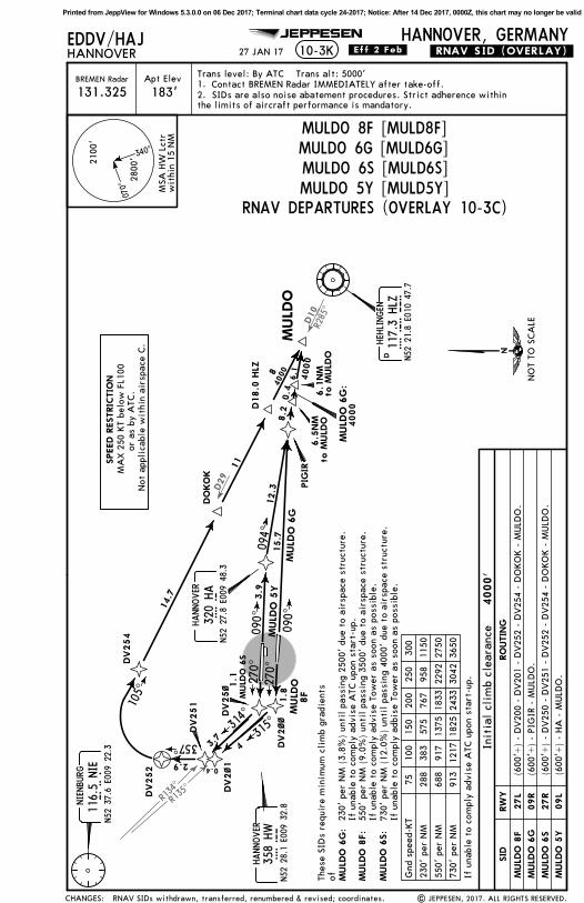
27 JAN 17
D
DEPARTURES
Cli
mb
stra
ight
ahe
ad t
o 0.
5 D
ME
WES
T of
HBD
/HA
D 2
.0 D
ME
or 6
00',
whi
chev
er i
s la
ter,
tur
n RI
GHT,
inte
rcep
t N
IE R
-135
inb
ound
to
D4.
2 HBD
/201
^ be
arin
g to
HW
, tu
rn R
IGHT,
357
^ tr
ack,
whe
n pa
ssin
gN
IE R
-118
tur
n RI
GHT,
int
erce
pt H
LZ R
-285
inb
ound
via
DO
KO
K t
o M
ULD
O.
Cli
mb
stra
ight
ahe
ad t
o PI
GIR
, tu
rn R
IGHT,
094
^ tr
ack
MULD
O.
730'
per
NM
913
1217
1825
2433
3042
3650
550'
per
NM
688
917
1375
1833
2292
2750
230'
per
NM
288
383
575
767
958
1150
Gnd
spe
ed-K
T75
100
150
200
250
300
D4.5
HBD
D
MULDO 8FMULDO 6GMULDO 6SMULDO 5Y
Cli
mb
stra
ight
ahe
ad t
o HA
D 2
.0 D
ME/
NIE
R-1
32 o
r 60
0',
whi
chev
er i
s la
ter,
tur
n RI
GHT,
int
erce
pt N
IER-
134
inbo
und
to D
5.2
HA
D/D
4.5
HBD
, tu
rn R
IGHT,
357
^ tr
ack,
whe
n pa
ssin
g N
IE R
-118
turn
RIG
HT,
int
erce
pt H
LZ R
-285
inb
ound
via
DO
KO
K t
o M
ULD
O.
Thes
e SI
Ds
requ
ire
min
imum
cli
mb
grad
ient
sof
230'
per
NM
(3.
8%)
unti
l pa
ssin
g 25
00'
due
to a
irsp
ace
stru
ctur
e. I
f un
able
to
com
ply
advi
se A
TCup
on s
tart
-up.
730'
per
NM
(12
.0%
) un
til
pass
ing
4000
'du
e to
air
spac
e st
ruct
ure.
If
unab
le t
o co
mpl
y ad
vise
Tow
eras
soo
n as
pos
sibl
e.
550'
per
NM
(9.
0%)
unti
l pa
ssin
g 35
00'
due
to a
irsp
ace
stru
ctur
e. I
f un
able
to
com
ply
advi
se T
ower
as s
oon
as p
ossi
ble.
At
or600'
whi
chev
er i
s la
ter
HBD 0
.5 D
ME/
HA
D 2
.0 D
ME
At
or600'
whi
chev
er i
s la
ter
HA
D 2
.0 D
ME/
NIE
R-1
32
NO
T TO
SCA
LE
MULD
O 6
S
09R
27R
09L
MULD
O 5
Y
CHANGES:
2.1.
27L
HANNOVER
HAD
N52
28.1
E009
41.7
(113
.95) H
AD
MA
X 2
50 K
T be
low
FL1
00or
as
by A
TC.
Not
app
lica
ble
wit
hin
airs
pace
C.
SPEED R
ESTRIC
TIO
N
MULD
O 6
G
MULD
O 8
F
HANNOVER
HB
DN52
27.3
E009
39.6
(116
.9) HBD
NIE
116.5
NIE
NIENBU
RG
N52
37.6
E009
22.3
HL
Z11
7.3
HLZ
HEH
LINGEN
N52
21.8
E010
47.7
HA
320
HA
HANNOVER
N52
27.8
E009
48.3
RW
YSID
RO
UTIN
G
| JEPPESEN, 2017 ALL RIGHTS RESERVED.SIDs withdrawn, transferred, renumbered & revised; coordinates.
Printed from JeppView for Windows 5.3.0.0 on 06 Dec 2017; Terminal chart data cycle 24-2017; Notice: After 14 Dec 2017, 0000Z, this chart may no longer be valid
R113^R115^R135^R134^
314^
315^
295^
293^
NIE 1YNIE 7G
NIE 7FNIE 9S
270^
EDDV/HAJHANNOVER
HANNOVER, GERMANY10-3D
Initial climb clearance 4000'
DME
.SID.
NIENBURG116.5 NIENIE
N52 37.6 E009 22.3
DME
Apt Elev
183'BREMEN Radar
Trans level: By ATC Trans alt: 5000'Contact BREMEN Radar immediately after take-off.
090^
090^
JEPPESEN
270^
adherence within the limits of aircraft performance is mandatory.
SIDs are also noise abatement procedures. Strict131.325
HANNOVER
358 HWHWN52 28.1 E009 32.8
340^
070^
2800'
2100'
within 15 NMMSA HW Lctr
.Eff.2.Feb.
HAD 2.0 DME(NIE R-132)
At
or 600'whichever is later
HAD 2.0 DME/NIE R-132 HBD
0.5 DMEHAD
2.0 DME
At
or 600'whichever is later
HBD 0.5 DME/HAD 2.0 DME
NIE 7F:
NIE 9S:
HAD 1.6 DMEHBD 2.9 DME
At
or 600'whichever is later
HAD 1.6 DME/HBD 2.9 DME
HAD 2.0 DMEHBD 3.1 DME
At
or 600'whichever is later
HBD 3.1 DME/HAD 2.0 DME
D
27 JAN 17
NIENBURG 7F (NIE 7F)NIENBURG 7G (NIE 7G)NIENBURG 9S (NIE 9S)NIENBURG 1Y (NIE 1Y)
DEPARTURES
Climb straight ahead to 0.5 DME WEST of HBD/HAD 2.0 DME or 600', whichever is later, turn RIGHT, intercept NIE R-135 inbound to NIE.
Climb straight ahead to HBD 3.1 DME/HAD 2.0 DME or 600', whichever is later,turn LEFT, intercept NIE R-115 inbound to NIE.
Climb straight ahead to HAD 2.0 DME/NIE R-132 or 600', whichever is later,turn RIGHT, intercept NIE R-134 inbound to NIE.
Climb straight ahead to HAD 1.6 DME/HBD 2.9 DME or 600', whichever is later,turn LEFT, intercept NIE R-113 inbound to NIE.
D
730' per NM 913 1217 1825 2433 3042 3650
550' per NM 688 917 1375 1833 2292 2750
Gnd speed-KT 75 100 150 200 250 300
If unable to comply advise Tower as soon as possible.
These SIDs require minimum climb gradientsof
550' per NM (9.0%) until passing 3500'due to airspace structure.730' per NM (12.0%) until passing 3000'due to airspace structure.
NOT TO SCALE
NIE 9S
NIE 7F
NIE 7G
NIE 1Y
CHANGES:
27L
09R
27R
09L
RWYSID ROUTING
HANNOVER
HADN52 28.1 E009 41.7
(113.95) HAD
HANNOVER
HBDN52 27.3 E009 39.6
(116.9) HBD
2.1.
MAX 250 KT below FL100or as by ATC.
Not applicable within airspace C.
SPEED RESTRICTION
| JEPPESEN, 2017. ALL RIGHTS RESERVED.NIE SIDs renumbered & revised; coordinates; chart reindexed.
Printed from JeppView for Windows 5.3.0.0 on 06 Dec 2017; Terminal chart data cycle 24-2017; Notice: After 14 Dec 2017, 0000Z, this chart may no longer be valid
296^
D
LEINE115.2 DLEDLE
N52 15.0 E009 53.0
HANNOVER358 HWHW
N52 28.1 E009 32.8
208^
N52 23.1 E009 28.1
R289^
109^
268^
270^090^
.SID.EDDV/HAJHANNOVER
HANNOVER, GERMANY
DME
10-3E
Initial climb clearance 4000'
Apt Elev
183'BREMEN Radar
Trans level: By ATC Trans alt: 5000'
SIDs are also noise abatement procedures. StrictContact BREMEN Radar IMMEDIATELY after take-off.
DME
090^
JEPPESEN
POVEL 3S
POVEL 3FPOVEL 2Y
POVEL 2H
POVEL
118^
21.6
4000
099^4000
091^2
131.325 adherence within the limits of aircraft performanceis mandatory.
340^
070^
2800'
2100'
within 15 NMMSA HW Lctr
HAD 4.5 DMEHBD 3.3 DME
HAD 4.7 DMEHBD 3.3 DME
HAD 8.4 DMEHBD 9.6 DME
D4.0 HAD/D5.4 HBD
D6.5 HADD7.8 HBD
Towards HW, at HAD 4.5 DME/HBD 3.3 DME turn LEFT, intercept 208^bearing from HW, when passing DLE R-296 turn LEFT, intercept DLE R-289inbound to DLE, turn LEFT, DLE R-099 to POVEL.
POVEL 3F:
These SIDs require minimum climb gradientsof
POVEL 3S:
D
21.6 NMTO POVEL
If unable to comply advise Tower as soon as possible.
Climb straight ahead to HAD 4.7 DME/HBD 3.3 DME, turn LEFT, intercept 208^bearing from HW, when passing DLE R-296 turn LEFT, intercept DLE R-289inbound to DLE, turn LEFT, DLE R-099 to POVEL.Climb straight ahead to HAD 8.4 DME/HBD 9.6 DME, turn RIGHT, 118^ track toPOVEL.
550' per NM (9.0%) until passing 3500'due to airspace structure.
670' per NM (11.0%) until passing 3000'due to airspace structure.
670' per NM 838 1117 1675 2233 2792 3350
550' per NM 688 917 1375 1833 2292 2750
Gnd speed-KT 75 100 150 200 250 300
4
09R
27R
09L
CHANGES:
NOT TO SCALE
27L
HANNOVER
HADN52 28.1 E009 41.7
(113.95) HAD HA320 HAHANNOVER
N52 27.8 E009 48.3
RWYSID ROUTING
MAX 250 KT below FL100or as by ATC.
Not applicable within airspace C.
SPEED RESTRICTION
2.1.
HANNOVER
HBDN52 27.3 E009 39.6
(116.9) HBD
POVEL 3F
POVEL 2H
POVEL 3S
POVEL 2Y
| JEPPESEN, 2017. ALL RIGHTS RESERVED.POVEL SIDs renumbered & revised; coordinates; chart reindexed.
Printed from JeppView for Windows 5.3.0.0 on 06 Dec 2017; Terminal chart data cycle 24-2017; Notice: After 14 Dec 2017, 0000Z, this chart may no longer be valid
Apt Elev
183'BREMEN Radar
Trans level: By ATC Trans alt: 5000'
EDDV/HAJHANNOVER
HANNOVER, GERMANY
Contact BREMEN Radar IMMEDIATELY after take-off.
10-3FJEPPESEN
131.325 SIDs are also noise abatement procedures. Strict adherence withinthe limits of aircraft performance is mandatory.
Printed from JeppView for Windows 5.3.0.0 on 06 Dec 2017; Terminal chart data cycle 24-2017; Notice: After 14 Dec 2017, 0000Z, this chart may no longer be valid
Glider areaHANNOVER SOUTHEAST
Glider areaHANNOVER SOUTHWEST
EDDV/HAJHANNOVER
HANNOVER, GERMANY10-3G
WARBURG113.7 WRBWRB
N51 30.3 E009 06.7
NORTA
WRB 1G
WRB 3S
WRB 8FWRB 3Y
185^
5000
R052^ 232^TOLTA
208^
268^
187^
R007^
4
090^
HANNOVER358 HWHW
N52 28.1 E009 32.8
DME
D
Initial climb clearance 4000'
4
4
Apt Elev
183'BREMEN Radar
Trans level: By ATC Trans alt: 5000'
SIDs are also noise abatement procedures. StrictContact BREMEN Radar IMMEDIATELY after take-off.
FLIGHTS TO EDDF END AT TOLTA
.SID.
DME
270^
JEPPESEN
090^
18.6
16
5000
ADSIN
5000
091^2
131.325 adherence within the limits of aircraft performance is mandatory.
3
1
223^
15.5
5000
1
1
2
2
340^
070^
2800'
2100'
within 15 NMMSA HW Lctr
ROLUK
5000
HAD 4.5 DMEHBD 3.3 DME
HAD 4.7 DMEHBD 3.3 DME HAD 6.5 DME
HBD 7.7 DME
D6.5 HADD7.8 HBD
D4.0 HAD/D5.4 HBD
3
3
WRB 8F:
WRB 3S:
2
D
If glider area HANNOVER SOUTHWEST is announced active on ATIS: Flights have to be ableto cross ADSIN at or above FL100. If unable to comply advise ATC upon start-up.If glider area HANNOVER SOUTHEAST is announced active on ATIS: Flights have to be ableto cross DLE at or above FL100. If unable to comply advise ATC upon start-up.
27 JAN 17 .Eff.2.Feb.
DEPARTURES
D
17.3
Climb straight ahead to HAD 6.5 DME/HBD 7.7 DME, turn RIGHT, intercept DLER-007 inbound to DLE, DLE R-185 to NORTA, 223^ track to TOLTA, 232^track to WRB.
Climb straight ahead to D6.5 HAD/D7.8 HBD, turn RIGHT, intercept DLER-007 inbound to DLE, DLE R-185 to NORTA, 223^ track to TOLTA, 232^track to WRB.
550' per NM (9.0%) until passing 3500'due to airspace structure.670' per NM (11.0%) until passing 3000'due to airspace structure.
670' per NM 838 1117 1675 2233 2792 3350
550' per NM 688 917 1375 1833 2292 2750
Gnd speed-KT 75 100 150 200 250 300
If unable to comply advise Tower as soon as possible.
After D12.0 HAD (D10.4 HBD) BRNAV equipment necessary.After DLE BRNAV equipment necessary.
173^
D12.0 HADD10.4 HBD
Towards HW, at HAD 4.5 DME/HBD 3.3 DME turn LEFT, intercept 208^ bearing fromHW to D12.0 HAD/D10.4 HBD, turn LEFT, 173^ track via ADSIN and ROLUK toTOLTA, turn RIGHT, 232^ track to WRB.
These SIDs require minimum climb gradientsof
4
Climb straight ahead to HAD 4.7 DME/HBD 3.3 DME, turn LEFT, intercept 208^bearing from HW to D12.0 HAD/D10.4 HBD, turn LEFT, 173^ track via ADSIN andROLUK to TOLTA, turn RIGHT, 232^ track to WRB.
CHANGES:
HANNOVER
HADN52 28.1 E009 41.7
(113.95) HAD
HA320 HAHANNOVER
N52 27.8 E009 48.3
DLE115.2 DLELEINE
N52 15.0 E009 53.0
09R
27R
09L
27L
RWYSID ROUTING
WRB 8F
WRB 1G
WRB 3S
WRB 3Y
2.1.
NOT TO SCALEMAX 250 KT below FL100
or as by ATC.Not applicable within airspace C.
SPEED RESTRICTION
HANNOVER
HBDN52 27.3 E009 39.6
(116.9) HBD
Glider areaHANNOVER SOUTHEAST and SOUTHWEST
Max: cleared by ATCLower: FL65
| JEPPESEN, 2017. ALL RIGHTS RESERVED.WRB SIDs renumbered & revised; coordinates; chart reindexed.
Printed from JeppView for Windows 5.3.0.0 on 06 Dec 2017; Terminal chart data cycle 24-2017; Notice: After 14 Dec 2017, 0000Z, this chart may no longer be valid
Glider areaHANNOVERSOUTHEAST
Glider areaHANNOVERSOUTHWEST
EDDV/HAJHANNOVER
HANNOVER, GERMANY10-3H
NORTA
185^
500
0
TOLTA
208^
268^
187^
R007^
4
090^
HANNOVER358 HWHW
N52 28.1 E009 32.8
DME
WERRA 3F:
Initial climb clearance 4000'
3
4
4
Apt Elev
183'BREMEN Radar
Trans level: By ATC Trans alt: 5000'
SIDs are also noise abatement procedures. StrictContact BREMEN Radar IMMEDIATELY after take-off.
.SID.
DME
270^
JEPPESEN
090^
5000
ADSIN
5000
091^2
131.325adherence within the limits of aircraft performance is mandatory.
1
1
1
2
2
340^
070^
2800'
2100'
within 15 NMMSA HW Lctr
ROLUK
WERRA 3S
HAD 4.5 DMEHBD 3.3 DME
16.0
WERRA15.55000
145^ WERRA 3S:
WERRA 3F
HAD 4.7 DMEHBD 3.3 DME
D4.0 HAD/D5.4 HBD
WERRA 3Y
D6.5 HADD7.8 HBD
24.
1500
0
WERRA 3G
HAD 6.5 DMEHBD 7.7 DME
2
D
If unable to comply advise Tower as soon as possible.
3
3
If glider area HANNOVER SOUTHWEST is announced active on ATIS: Flights have to be ableto cross ADSIN at or above FL100. If unable to comply advise ATC upon start-up.If glider area HANNOVER SOUTHEAST is announced active on ATIS: Flights have to be ableto cross DLE at or above FL100. If unable to comply advise ATC upon start-up.
27 JAN 17 .Eff.2.Feb.
DEPARTURES
D
Climb straight ahead to HAD 6.5 DME/HBD 7.7 DME, turn RIGHT, intercept DLER-007 inbound to DLE, DLE R-185 via NORTA to WERRA.
Climb straight ahead to D6.5 HAD/D7.8 HBD, turn RIGHT, intercept DLER-007 inbound to DLE, DLE R-185 via NORTA to WERRA.
D
WERRA 3F, WERRA 3GWERRA 3S, WERRA 3Y
These SIDs require minimum climb gradientsof
173^
D12.0 HADD10.4 HBD
17.3
12.9
10.
2
670' per NM 838 1117 1675 2233 2792 3350
550' per NM 688 917 1375 1833 2292 2750
Gnd speed-KT 75 100 150 200 250 300
10.2 NMto NORTA
670' per NM (11.0%) until passing3000' due to airspace structure.
4 After DLE BRNAV equipment necessary.After D12.0 HAD (D10.4 HBD) BRNAV equipment necessary.
Climb straight ahead to HAD 4.7 DME/HBD 3.3 DME, turn LEFT, intercept 208^bearing from HW to D12.0 HAD/D10.4 HBD, turn LEFT, 173^ track via ADSIN and ROLUK to TOLTA, 145^ track to WERRA.
Towards HW, at HAD 4.5 DME/HBD 3.3 DME turn LEFT, intercept 208^ bearing from HW, to D12.0 HAD/D10.4 HBD, turn LEFT, 173^ track via ADSIN and ROLUKto TOLTA, 145^ track to WERRA.
550' per NM (9.0%) until passing3500' due to airspace structure.
CHANGES:
HANNOVER
HADN52 28.1 E009 41.7
(113.95) HAD
HA320 HAHANNOVER
N52 27.8 E009 48.3
DLE115.2 DLELEINE
N52 15.0 E009 53.0
09R
27R
09L
27L
RWYSID ROUTING
2.1.
NOT TO SCALE
HANNOVER
HBDN52 27.3 E009 39.6
(116.9) HBD
WERRA 3S
WERRA 3F
WERRA 3Y
WERRA 3G
SPEED RESTRICTION
| JEPPESEN, 2017. ALL RIGHTS RESERVED.WERRA SIDs renumbered & revised; coordinates; chart reindexed.
MAX 250 KT below FL100or as by ATC.
Not applicable within airspace C.
Glider areaHANNOVER SOUTHEAST and SOUTHWEST
Max: cleared by ATCLower: FL65
Printed from JeppView for Windows 5.3.0.0 on 06 Dec 2017; Terminal chart data cycle 24-2017; Notice: After 14 Dec 2017, 0000Z, this chart may no longer be valid
R134^
R135^
314^
315^
357^
CEL 6Y
CEL 9GDV154
DV1~28.6
7.7
1.8DV2~~
DV2~1
DV251
3.7
DV253
090^
090^
270^270^
CEL 8F
0.4
4.5
4
DV25~
CEL 6S1.1
.RNAV.SID.(OVERLAY).EDDV/HAJHANNOVER
HANNOVER, GERMANY
087^
10-3J
17.5
023^
0.8
Initial climb clearance 4000'
Apt Elev
183'BREMEN Radar
Trans level: By ATC Trans alt: 5000'
SIDs are also noise abatement procedures. StrictContact BREMEN Radar IMMEDIATELY after take-off.
8.6
JEPPESEN
131.325
HANNOVER358 HWHW
N52 28.1 E009 32.8
(600'+) - DV200 - DV201 - DV253 - CEL.
(600'+) - DV154 - CEL.
(600'+) - DV250 - DV251 - DV253 - CEL.
(600'+) - DV102 - CEL.
340^
070^
2800'
2100'
within 15 NMMSA HW Lctr
CEL 8F:of
CEL 6S:
adherence within the limits of aircraft performance ismandatory.
If unable to comply advise Tower as soon as possible.
550' per NM (9.0%) until passing 3500' dueto airspace structure.730' per NM (12.0%) until passing 4000' dueto airspace structure.
NOT TO SCALE
CHANGES:
CEL 8F 27L
CEL 9G 09R
CEL 6S 27R
09LCEL 6Y
RWYSID ROUTING
CEL311 CELCELLE
N52 35.4 E010 01.8
NIE116.5 NIENIENBURG
N52 37.6 E009 22.3
2.1.
MAX 250 KT below FL100or as by ATC.
Not applicable within airspace C.
SPEED RESTRICTION
| JEPPESEN, 2017. ALL RIGHTS RESERVED.CEL RNAV SIDs renumbered & revised; coordinates; chart reindexed.
Printed from JeppView for Windows 5.3.0.0 on 06 Dec 2017; Terminal chart data cycle 24-2017; Notice: After 14 Dec 2017, 0000Z, this chart may no longer be valid
D10
R285^
R134^
R135^
D29
.RNAV.SID.(OVERLAY).EDDV/HAJHANNOVER
HANNOVER, GERMANY10-3K
314^
315^
MULD
O 5
Y
MULD
O 6
G
094^
105^
090^
090^
3.9
15. 7
12.3
PIG
IR
8F
1.8
DV2~~
DV2~1
DV251
1.1
3.7
DV252
MULD
O
DV254
DV25~
4
0.42.9
357^
4000
14.7
88.2
270^
MULD
O 6
G:
4000
MULD
O4000
Init
ial
clim
b cl
eara
nce
4000'
RNAV DEPARTURES (OVERLAY 10-3C)
Apt Elev
183'BREMEN Radar
Trans level: By ATC Trans alt: 5000'Contact BREMEN Radar IMMEDIATELY after take-off.
270^
MULD
O 6
S
JEPPESEN
DO
KO
K
11
131.325 SIDs are also noise abatement procedures. Strict adherence withinthe limits of aircraft performance is mandatory.
RNAV SIDs withdrawn, transferred, renumbered & revised; coordinates. | JEPPESEN, 2017. ALL RIGHTS RESERVED.
Printed from JeppView for Windows 5.3.0.0 on 06 Dec 2017; Terminal chart data cycle 24-2017; Notice: After 14 Dec 2017, 0000Z, this chart may no longer be valid
NIENBURG116.5 NIENIE
N52 37.6 E009 22.3
R113^R115^R135^
R134^
314^
315^
295^
293^
NIE 1Y
NIE 7G
NIE 7FNIE 9S
DV2~~
DV25~
13.813.2
270^
270^1.1
1.8
090^
090^
1.2
1.4
DV15~
DV1~~
DV151
DV152
DV1~1
14.5
16.2
RNAV DEPARTURES (OVERLAY 10-3D)
.RNAV.SID.(OVERLAY).EDDV/HAJHANNOVER
HANNOVER, GERMANY10-3L
Initial climb clearance 4000'
Apt Elev
183'BREMEN Radar
Trans level: By ATC Trans alt: 5000'
SIDs are also noise abatement procedures. StrictContact BREMEN Radar IMMEDIATELY after take-off.
DV111
JEPPESEN
131.325
HANNOVER358 HWHW
N52 28.1 E009 32.8
(600'+) - DV200 - NIE.
(600'+) - DV150 - DV151 - DV152 - NIE.
(600'+) - DV250 - NIE.
(600'+) - DV100 - DV111 - DV101 - NIE.
340^
070^
2800'
2100'
within 15 NMMSA HW Lctr
.Eff.2.Feb.
adherence within the limits of aircraft performance ismandatory.
NIE 7F:
These SIDs require a minimum climb gradientof
NIE 9S:
If unable to comply advise Tower as soon as possible.
27 JAN 17
NIENBURG 7F (NIE 7F)NIENBURG 7G (NIE 7G)NIENBURG 9S (NIE 9S)NIENBURG 1Y (NIE 1Y)
550' per NM (9.0%) until passing 3500' due to airspace structure.
730' per NM (12.0%) until passing 3000' due to airspace structure.
730' per NM 913 1217 1825 2433 3042 3650
550' per NM 688 917 1375 1833 2292 2750
Gnd speed-KT 75 100 150 200 250 300
NIE 7F
NIE 7G
NIE 9S
NIE 1Y
CHANGES:
27L
09R
27R
09L
RWYSID ROUTING
2.1.
NOT TO SCALE
MAX 250 KT below FL100or as by ATC.
Not applicable within airspace C.
SPEED RESTRICTION
| JEPPESEN, 2017. ALL RIGHTS RESERVED.NIE RNAV SIDs renumbered & revised; coordinates; chart reindexed.
Printed from JeppView for Windows 5.3.0.0 on 06 Dec 2017; Terminal chart data cycle 24-2017; Notice: After 14 Dec 2017, 0000Z, this chart may no longer be valid
D
208^
R289^
109^
268^
8.3
7.4
17.5
DV256
5.1
270^DV2~2
090^
090^
0.7
7.2
RNAV DEPARTURES (OVERLAY 10-3E)
.RNAV.SID.(OVERLAY).EDDV/HAJHANNOVER
HANNOVER, GERMANY10-3M
LEINE
115.2 DLEDLEN52 15.0 E009 53.0
HANNOVER358 HWHW
N52 28.1 E009 32.8
Initial climb clearance 4000'
Apt Elev
183'BREMEN Radar
Trans level: By ATC Trans alt: 5000'
SIDs are also noise abatement procedures. StrictContact BREMEN Radar IMMEDIATELY after take-off.
JEPPESEN
POVEL 3S
POVEL 3F
POVEL 2Y
POVEL 2H
118^
POVEL
21.6
4000
099^4000
DV1~5
DV157
16.4
1.6
35.6
131.325
(600'+) - DV202 - DV256 - DLE - POVEL.
(600'+) - DV157 - POVEL.
(600'+) - HW - DV256 - DLE - POVEL.
(600'+) - DV105 - POVEL.
340^
070^
2800'
2100'
within 15 NMMSA HW Lctr
.Eff.25.May.
21.6 NMto POVEL
adherence within the limits of aircraft performance ismandatory.
These SIDs require a minimum climb gradientofPOVEL 3F:
POVEL 3S:
If unable to comply advise Tower as soon as possible.
550' per NM (9.0%) until passing 3500'due to airspace structure.670' per NM (11.0%) until passing 3000'due to airspace structure.
(117.3 HLZ R-173)
NOT TO SCALE
CHANGES:
MAX 250 KT below FL100or as by ATC.
Not applicable within airspace C.
SPEED RESTRICTION
27L
09R
27R
09L
RWYSID ROUTING
2.1.
POVEL 3F
POVEL 2H
POVEL 3S
POVEL 2Y
| JEPPESEN, 2017. ALL RIGHTS RESERVED.None.
Printed from JeppView for Windows 5.3.0.0 on 06 Dec 2017; Terminal chart data cycle 24-2017; Notice: After 14 Dec 2017, 0000Z, this chart may no longer be valid
Apt Elev
183'BREMEN Radar
Trans level: By ATC Trans alt: 5000'
EDDV/HAJHANNOVER
HANNOVER, GERMANY
Contact BREMEN Radar IMMEDIATELY after take-off.
10-3NJEPPESEN
131.325 SIDs are also noise abatement procedures. Strict adherence withinthe limits of aircraft performance is mandatory.
Printed from JeppView for Windows 5.3.0.0 on 06 Dec 2017; Terminal chart data cycle 24-2017; Notice: After 14 Dec 2017, 0000Z, this chart may no longer be valid
Glider areaHANNOVERSOUTHWEST
Glider areaHANNOVERSOUTHEAST
NORTA
208^
268^WRB 3S
WRB 8FWRB 3Y
185^
5.8
6.4DV1~3
DV153
DV257
5.1
DV2~2
090^
090^
0.7
8.9
WRB 1G
5000
223^
15.5
5000
.RNAV.SID.(OVERLAY).
10.2
187^
R007
^
DV1~4
DV156
0.7
9.5
R052^ 232^
5000TOLTA
18.6
EDDV/HAJHANNOVER
HANNOVER, GERMANY10-3P
Initial climb clearance 4000'
WARBURG113.7 WRBWRB
N51 30.3 E009 06.7
HANNOVER358 HWHW
N52 28.1 E009 32.8
D
270^
Apt Elev
183'BREMEN Radar
Trans level: By ATC Trans alt: 5000'
SIDs are also noise abatement procedures. StrictContact BREMEN Radar IMMEDIATELY after take-off.
FLIGHTS TO EDDF END AT TOLTARNAV DEPARTURES (OVERLAY 10-3G)
JEPPESEN
16
5000
ADSIN
5000
ROLUK
5.6
17.3
131.325 adherence within the limits of aircraft performance is mandatory.
These SIDs require a minimum climb gradientofWRB 8F:
WRB 3S:
If unable to comply advise Tower as soon as possible.
If glider area HANNOVER SOUTHWEST is announced active on ATIS: Flights have to be ableto cross ADSIN at or above FL100. If unable to comply advise ATC upon start-up.If glider area HANNOVER SOUTHEAST is announced active on ATIS: Flights have to be ableto cross DLE at or above FL100. If unable to comply advise ATC upon start-up.
550' per NM (9.0%) until passing 3500'due to airspace structure.670' per NM (11.0%) until passing 3000'due to airspace structure.
NOT TO SCALE
RWYSID
WRB 8F 27L
WRB 1G 09R
WRB 3S 27R
09LWRB 3Y
ROUTING
CHANGES:
DLE115.2 DLELEINE
N52 15.0 E009 53.0
MAX 250 KT below FL100or as by ATC.
Not applicable within airspace C.
SPEED RESTRICTION
2.1.
Glider areaHANNOVER SOUTHEAST and SOUTHWEST
Max: cleared by ATCLower: FL65
| JEPPESEN, 2017. ALL RIGHTS RESERVED.New chart (WRB RNAV SIDs renumbered & revised; coordinates).
Printed from JeppView for Windows 5.3.0.0 on 06 Dec 2017; Terminal chart data cycle 24-2017; Notice: After 14 Dec 2017, 0000Z, this chart may no longer be valid
Glider areaHANNOVERSOUTHWEST
Glider areaHANNOVERSOUTHEAST
NORTA
208^
268^
187^
R007^
185^
5.8
6.4DV1~3
DV153
DV257
5.1
270^DV2~2
090^
090^
8.9
0.7
5000
RNAV DEPARTURES (OVERLAY 10-3H)
10.2
DV1~4
DV156
0.7
9.5
.RNAV.SID.(OVERLAY).EDDV/HAJHANNOVER
HANNOVER, GERMANY10-3Q
HANNOVER358 HWHW
N52 28.1 E009 32.8
Initial climb clearance 4000'
Apt Elev
183'BREMEN Radar
Trans level: By ATC Trans alt: 5000'
SIDs are also noise abatement procedures. StrictContact BREMEN Radar IMMEDIATELY after take-off.
adherence within the limits of aircraft performance ismandatory.
These SIDs require a minimum climb gradientofWERRA 3F:
WERRA 3S:
If unable to comply advise Tower as soon as possible.
If glider area HANNOVER SOUTHWEST is announced active on ATIS: Flights have to be ableto cross ADSIN at or above FL100. If unable to comply advise ATC upon start-up.If glider area HANNOVER SOUTHEAST is announced active on ATIS: Flights have to be ableto cross DLE at or above FL100. If unable to comply advise ATC upon start-up.
550' per NM (9.0%) until passing 3500'due to airspace structure.670' per NM (11.0%) until passing 3000'due to airspace structure.
670' per NM 838 1117 1675 2233 2792 3350
550' per NM 688 917 1375 1833 2292 2750
Gnd speed-KT 75 100 150 200 250 300
CHANGES:
27L
09R
27R
09L
DLE115.2 DLELEINE
N52 15.0 E009 53.0
NOT TO SCALE
MAX 250 KT below FL100or as by ATC.
Not applicable within airspace C.
SPEED RESTRICTION
RWYSID ROUTING
2.1.
WERRA 3F
WERRA 3G
WERRA 3S
WERRA 3Y
Glider areaHANNOVER SOUTHEAST and SOUTHWEST
Max: cleared by ATCLower: FL65
| JEPPESEN, 2017. ALL RIGHTS RESERVED.New chart (WERRA RNAV SIDs renumbered & revised; coordinates).
Printed from JeppView for Windows 5.3.0.0 on 06 Dec 2017; Terminal chart data cycle 24-2017; Notice: After 14 Dec 2017, 0000Z, this chart may no longer be valid
02^E
For
AIR
PO
RT B
RIE
FIN
G
refe
r to
10-1
P p
ages (For
inf
orm
atio
n on
ly,
not
to b
e co
nstr
ued
as A
TC i
nstr
ucti
ons.
)
HO
T SP
OTS
197'
Stop
way
60m
558'
Stop
way
170m
FO
R D
ETA
ILS
SEE 1
0-9
A
52-27
52-27
52-28
52-28
09-39
09-39
09-40
09-40
09-41
09-41
09-42
09-42
09-43
09-43
HA
NN
OVER
Gro
und
Tow
er
183'
HA
NN
OVER
HANNOVER
, GER
MANY
N52
27.
6 E
009
41.0
EDDV/H
AJ
ACA
RS:
DCL
*D
-ATI
S
Apt
Ele
v
136.
575
121.
950
120.
175
JEPPESEN
10-9 C
AT
I ho
ldin
g po
ints
of
RWY 0
9C/2
7C.
Due
to
obst
acle
lim
itat
ion
surf
ace
- CA
T I
hold
ing
poin
t in
gre
ater
dis
tanc
e to
RW
Y.
Bla
st
Fenc
e
Bla
st
Fenc
e
| J
EPPE
SEN
, 20
15,
2017
. A
LL R
IGHTS
RES
ERVED
.
3 N
OV 1
7
TWY M
bet
wee
n TW
Y L
and
F e
stab
lish
ed.Ru
n-up
test
are
a
Lim
it o
f ap
ron
cont
rol
com
pete
nce
LEG
END
Rwy
guar
d li
ghts
HO
T SP
OTS
ARP
09R
27L
09L
27R
1 0,499
' 32 0
0m
7 677
'23
40m
B
A1
D
CB
AA
MK
JH
G
G
Elev
172'
Elev
179'
NK t
o
L
M
OP
L
HA
NG
AR 2
H2
Elev
Elev
2 71 ^
0 91 ^
0 91 ^
2 71 ^
172'
165'
F
A2
A1
HA
NG
AR 1
27C
2 72 ^
Elev
174'
Elev
178'
2 559
'78
0m
AA
T2
HA
NG
AR 3
F
Con
trol
Tow
er
C1
C2
A2
G1
G2
E2 E1
0 92 ^
09C
H1
H3
GA
1
GA
3
GA
2
Q
500
2000
2500 80
060
020
0
Feet
Meters
0 010
00
3000
1000
1500
400
CH
AN
GES
:
M
HS1
HS2
HS1
HS1
HS2
HS2
HS1
Printed from JeppView for Windows 5.3.0.0 on 06 Dec 2017; Terminal chart data cycle 24-2017; Notice: After 14 Dec 2017, 0000Z, this chart may no longer be valid
LEG
END
EDDV/H
AJ
A2
NO
T TO
SCA
LE
JEPPESEN
Deicing
A
D
D1
Dei
cing
A
1617
17A18
19A
19
20
2122
23
A2
A1
A
C
A
L
A
B
F
C
21A
F1
L1
A1
A1
D1
1515
A
RWY 0
9L/2
7R
HA
NG
AR
11
HA
NG
AR
12
HA
NG
AR
13
HA
NG
AR
14
HA
NG
AR
15
RWY 0
9R/2
7 L
Dei
cing
sta
ndTa
xiw
aySt
and
Bla
st f
ence
Lim
it o
f ap
ron
cont
rol
com
pete
nce
RWY 0
9C/ 2
7C
18A
3 N
OV 1
7
HA
NG
AR 1
6
HANNOVER
, GER
MANY
HA
NN
OVER
8
10-9
A
CH
AN
GES
:
DP1
5354
5556
5758
59
61
58A
5251
5049
484761
R
57R
56R
54R
51R
49R
48R
59R
53R
2 3
45
67
89
10
11
26
4240
5A
10A
FREIG
HT
BUIL
DIN
G
41
BUIL
DIN
G
12
TERM
INA
L
13
14
1A
60R
60
60A
4645
45R
46R
42R
40R
27A
7A
DP2
DP1
H1
N
M
Q
ARP
L
M
O
P
L
H2
T2
F
Con
trol
Tow
er
H3
GA
1
GA
2
Rwy
guar
d li
ghts
HO
T SP
OTS
GA
3
11A
14A
1
2A
27R
28
27
| J
EPPE
SEN
, 20
15,
2017
. A
LL R
IGHTS
RES
ERVED
.
M
TWY M
bet
wee
n TW
Y L
and
F e
stab
lish
ed.
C
A
B
See
10-9
for
des
crip
tion
of H
otsp
ots.
HS2
HS2
HS2
HS1
Printed from JeppView for Windows 5.3.0.0 on 06 Dec 2017; Terminal chart data cycle 24-2017; Notice: After 14 Dec 2017, 0000Z, this chart may no longer be valid
1804'
EDDV/HAJ
6627' 2020m(30m)
2001'550m
610m
| JEPPESEN, 1999, 2015. ALL RIGHTS RESERVED.
JEPPESEN
14 APR 17
TAKE-OFF
ABCD
Day: RL or RCLMNight: RL or CL (Day only)
Adequate vis refHIRL, CL &relevant RVR
RL, CL &relevant RVR RL & CL
Day: RL & RCLMNight: RL or CL
Low Visibility Take-off
.Standard.
TDZ, MID, RO TDZ, MID, RO
RVR 125m 150m 200m 400m 500mRVR RVR 300mRVR
10-9A1HANNOVER, GERMANY
HANNOVER
RWY
ADDITIONAL RUNWAY INFORMATION
ThresholdLANDING BEYOND
USABLE LENGTHS
WIDTHTAKE-OFFGlide Slope
27R09L
RVRRVR 9466' 2885m
2904m9527' 2 45m148'
2
09C27C 23m
74'
CHANGES:
(15m)
HIRL CLHIRL CL
(15m)
Additional 984'/300m starter extension available with PPO.
Printed from JeppView for Windows 5.3.0.0 on 06 Dec 2017; Terminal chart data cycle 24-2017; Notice: After 14 Dec 2017, 0000Z, this chart may no longer be valid
Printed from JeppView for Windows 5.3.0.0 on 06 Dec 2017; Terminal chart data cycle 24-2017; Notice: After 14 Dec 2017, 0000Z, this chart may no longer be valid
CHANGES:
EDDV/HAJ JEPPESEN
WARNING: Do not start docking procedure unless one of the routine docking process displays areshown or if a pilot is unsure about the indicated information.
1. START OF DOCKINGyellow
red
The floating arrows indicatethat the system is activatedand in capture mode, searchingfor an approaching aircraft.It shall be cheked, that thecorrect aircraft type is displayed.The lead-in line shall be followed.THE PILOT MUST NOT PROCEEDBEYOND THE BRIDGE, UNLESS THEARROWS HAVE BEEN SUSPENDEDBY THE CLOSING RATE BAR.
When the aircraft has beencaught by the laser, the floatingarrow is replaced by the yellowcenter line indicator. A flashingred arrow indicates the directionto turn.The vertical yellow arrow showsposition in relation to center line.This indicator gives correctposition and azimuth guidance.
2. TRACKING
3. CLOSING RATEThe closing rate is the finalcountdown from 30m distanceto the stop position.A yellow vertical closing ratebar / center line indicatorappears with thr digitalcountdown.
If the aircraft is approachingfaster than the accepted speed,the system will show SLOW asa warning to the pilots.
5. STOP POSITION REACHEDWhen the correct stop positionis reached, the display will showSTOP with red lights.
6. DOCKING COMPLETEDWhen the aircraft has parked,OK will be displayed.
7. ON BLOCK TIMEOn block time will bedisplayed in UTC-time.
8. CHOCK ONCHOCK ON will be displayed,when the ground staff hasput the chocks in front of andbehind the main gear wheelsand pressed the "Chocks on"button on the operator panel.It disappears after 180 seconds.
DISPLAYED FORMS AT ABNORMAL CONDITIONS
Form:Acft typeDisplay black with red lightsDisplay complete blackERRORERR10WAITWAIT followed by GATE BLOCK STOPSTOP followed by ID FAILSTOP followed by TOO FAST STOP followed by SBUSTOP followed by OKSTOP / ABORTTOO FAR
Indication for:(preselected)System breakdown - stopPower failure - stopSystem errorSystem error (communication error with system)Not allowed object within scanning range - stopNot allowed object within scanning range when system starts - stand not usableEmergency stopIdentification failed - stopDocking system must be restarted or the docking procedure completed by manual guidanceToo far of center line within last 10' / 3m to stop positionNot correct stop position is reached but within limitsDocking is interrupted by gate operatorAcft has overshot the stop position (more than 1m)
4. SLOW (DECREASE SPEED)
6 FEB 15
Printing sequence. | JEPPESEN, 2011, 2015. ALL RIGHTS RESERVED.
HANNOVERHANNOVER, GERMANY
10-9C10-9C
ADVANCED VISUAL DOCKING GUIDANCE SYSTEM (A-VDGS)
Printed from JeppView for Windows 5.3.0.0 on 06 Dec 2017; Terminal chart data cycle 24-2017; Notice: After 14 Dec 2017, 0000Z, this chart may no longer be valid
845'
104^
WUNSTORF
306^
082^ 299^
1000
1000
1000
D10.3
185^
3000
7.3
HAD
DESIM
11-1HANNOVERHANNOVER, GERMANY
LOCIHNE
108.3
FinalApch Crs
090^
GS
1460'(1293')
ILSDA(H)
MISSED APCH:
Alt Set: hPa (IN on req) Rwy Elev: 6 hPa Trans level: By ATC Trans alt: 5000'
Gnd speed-Kts 70 90 100 120 140 160
PAPIREIL
BRIE
FIN
G S
TRIP
TMHANNOVER Tower GroundBREMEN Radar (APP) HANNOVER Director (APP)
EDDV/HAJ
HADD8.0
Strict adherence to the procedure is required due to IFR traffic at Wunstorf.
HADD8.0
D10.3 HAD
D2.0 HAD
DA(H)
ALSF-II
181^
001^ 40
00
| JEPPESEN, 1999, 2017. ALL RIGHTS RESERVED.
*D-ATIS
ILS
090^ 108.3 IHNEI H N E
HADD4.0
HADD4.0
JEPPESEN
.Standard.
3.00^
HW Lctr
340^
070^
2800'
2100'
within 15 NMMSA HW Lctr
372 478 531 637 743 849
HANNOVER
HBDD
3000
HBDD9.1HBDD6.8
HBDD4.2
HBDD2.9
HADD1.5
HBDD2.9
D9.1 HBD D6.8 HBD D4.2 HBD
D2.9 HBD
136.575 131.325 118.050 121.950
D1.5
LOC: DME required.
ILS or LOC Rwy 09L
(116.9) HBD
Climb STRAIGHT AHEAD to D1.5 EAST of HAD/D2.9 EAST of HBD.Then turn LEFT inbound NIE VORclimbing to 4000'.
LEINE115.2 DLEDLED
EAST of HADD2.9 EAST of HBD
Apt Elev 183'
Rwy 167'
27 JAN 17 .Eff.2.Feb.
120.175
24.2
CAUTION: Intensive Glider activities to be expected in the surrounding area of CEL NDB.
05
510
1520
CELLE311 CELCEL
257^
077^
4000
52-20
52-30
52-40
09-20
09-30 09-40 09-50 10-00
10-10
693'732'
941'1688' 707'
1056'598'671'
640'629'
625'
706'1096'604'
627'
589'
685' 588'640'
599'703' 599'
739'
119.6
6.0
11
ROBEG
ROBEG
D(113.95) HAD
HANNOVER
116.5 NIENIENBURG
358 HWHANNOVER
090^MM
H A DH W
N I E(IAF)
4000
007^
13.4
D5.4 HAD
LOC(GS out) ALTITUDE
HAD DME 7.0 5.0 4.0 3.08.0
MMC
2.3 0.51.4 Rwy 167'
090^3000'
1460'LOC
1460'
2300' 1980' 1660' 1340' 1020' 700'
D5.4 HAD
STRAIGHT-IN LANDING RWY
A
B
C
D
FULL ALS out ALS out
ILS LOC (GS out)09L
DA(H) 550'(383')
CHANGES:
RVR 1200m
GS
367'(200')
RVR 550m
9.010.02610'2930'
LOC2290'
2.6
DESIM
D2.0 HAD
2.01020'LOC
RVR 1500m
RVR 1800m
1100mRVR
LOC Descent Angle
Limited
RVR 750m
ILS GS or
HW Lctr
MAP at MM/D2.0 HAD
PA
NS O
PS
R-132 NIE
TCH 50'
Procedure.
367'(200')
273^4000
(IAF)
(IAF)
(R-1
87 N
IE)
HOLDING FIX
007 ^
187 ^
4000
Printed from JeppView for Windows 5.3.0.0 on 06 Dec 2017; Terminal chart data cycle 24-2017; Notice: After 14 Dec 2017, 0000Z, this chart may no longer be valid
WUNSTORF
104^
306^
082^ 299^
1000
1000
1000
CAT II/III ILS Rwy 09L
DESIM
HANNOVERHANNOVER, GERMANY
LOCIHNE
108.3
FinalApch Crs
090^
GS
1460'(1293')
Apt Elev
Rwy
183'
167'
MISSED APCH:
Alt Set: hPa (IN on req) Rwy Elev: 6 hPa Trans level: By ATC Trans alt: 5000'
Gnd speed-Kts 70 90 100 120 140 160
BRIE
FIN
G S
TRIP
TMHANNOVER Tower GroundBREMEN Radar (APP) HANNOVER Director (APP)
EDDV/HAJ
D10.3 HAD
D2.0 HAD
| JEPPESEN, 1999, 2017. ALL RIGHTS RESERVED.
*D-ATIS
JEPPESEN
.Standard.
3.00^
HW LctrRefer to
Minimums
340^
070^
2800'
2100'
within 15 NMMSA HW Lctr
372 478 531 637 743 849
D9.1 HBD D4.2 HBD
136.575 131.325 118.050 121.950
11-1A
CAT II ILS
DA(H) (100')
RA 101'267'
STRAIGHT-IN LANDING RWY 09L
RVR 300m 1
50'
200mRVR
DH
CAT IIIA ILS
1 Operators applying U.S. Ops Specs: Autoland or HUD required below RVR 350m.
.Eff.2.Feb.
CAT II &IIIA ILS
EAST of HBD.Then turn LEFT inbound NIE VOR climbing to 4000'.
3000'
PAPIREIL
ALSF-II D1.5 EAST of HADD2.9 EAST of HBD
27 JAN 17
120.175
D10.3
185^
3000
7.3
HAD
Strict adherence to the procedure is required due to IFR traffic at Wunstorf.
181^
001^ 40
00
ILS
090^ 108.3 IHNEI H N E
HANNOVER
HBDD
3000
HBDD9.1HBDD4.2
HADD1.5
HBDD2.9
(116.9) HBD
LEINE115.2 DLEDLED
24.2
CAUTION: Intensive Glider activities to be expected in the surrounding area of CEL NDB.
CELLE311 CELCEL
257^
077^
4000
52-20
52-30
52-40
09-20 09-30 09-40 09-50 10-00
10-10
693'732'
1688' 707' 1056'
598'671'
640'629'
625'
706'1096'604'
627'
589'
685' 588'640'
599'703' 599'
739'
05
510
1520
Climb STRAIGHT AHEAD to D1.5 EAST of HAD/D2.9
119.6
11
ROBEG
ROBEG
MMC
0.53.4 Rwy 167'
090^
1460'
D5.4 HAD
CHANGES:
GS
4.9
HW Lctr
PA
NS O
PS
GS
TCH 50'
Minimums.
D(113.95) HAD
HANNOVER
116.5 NIENIENBURG
358 HWHANNOVER
090^MM
H A DH W
N I E(IAF)
4000
007^
13.4
D5.4 HADDESIM
D2.0 HADR-132 NIE
273^4000
(IAF)
(IAF)
(R-1
87 N
IE)
HOLDING FIX
007 ^
187 ^
4000
Printed from JeppView for Windows 5.3.0.0 on 06 Dec 2017; Terminal chart data cycle 24-2017; Notice: After 14 Dec 2017, 0000Z, this chart may no longer be valid
WUNSTORF
099^
076^297^
306^
1000
1000
1000
1000
090^
D0.0 HBD
4000
LEINE115.2 DLE
DD L E
ROBEG
HANNOVERDH B D(116.9) HBD
(IAF)
HBDD6.2
PIXELD8.1 HBD
178^
8.5
3000
007^
12.4
4000
11-2HANNOVERHANNOVER, GERMANY
LOCIHSE
108.7
FinalApch Crs
090^
GS
1500'(1328')
ILSDA(H)
(200')372'
STRAIGHT-IN LANDING RWY
A
B
C
D
ILS LOC (GS out)09R
DA(H) DA(H) 570'372'(200') (398')
Gnd speed-Kts 70 90 100 120 140 160
BRIE
FIN
G S
TRIP
TM
EDDV/HAJILS or LOC Rwy 09R
Alt Set: hPa (IN on req) Trans level: By ATC Trans alt: 5000'
MISSED APCH:
DME required.
187^
266^
| JEPPESEN, 1999, 2017. ALL RIGHTS RESERVED.
Strict adherence to the procedure is required due to IFR traffic at Wunstorf.
05
510
1520 (IAF)
D23.0/R-266 DLE
HBDD2.0
D3.4 HBD
D3.4HBD
JEPPESEN
3.00^
.Standard.
340^
070^
2800'
2100'
within 15 NMMSA HW Lctr
HANNOVER358 HWHW
372 478 531 637 743 849
HANNOVER Tower GroundBREMEN Radar (APP) HANNOVER Director (APP)*D-ATIS
136.575 131.325 118.050 121.950
3000 D9.4 HAD
D7.5HAD HAD
D4.7 R-324 DLE
D6.5 HAD
007^ 18
7^
HANNOVER
HADD
(113.95) HAD
D9.4 HAD D7.5 HADD4.7 HAD D3.4 HAD
Climb STRAIGHT AHEAD to D7.7 HBD/D6.5 HAD,
on R-266 DLE to ROBEG climbing to 4000'.then turn RIGHT on R-007 DLE inbound to DLE VOR. Turn RIGHT
D7.7HBDD6.5 HAD
HIALS
PAPIREIL
Apt Elev 183'
Rwy 172'
27 JAN 17 .Eff.2.Feb.
120.175
CELLE
311 CELCEL
NIENBURG116.5 NIENIE
273^ 24.24000
077^
693'
1109' 822' 680'762'
714'732'
1611'
1688'
707'
598'671'
640'629'
625'1096'
604'627'
745'
685'
845'
655'
739'
D3.4 HAD
52-20
52-30
09-10 09-20
09-30 09-40 09-50 10-00
CAUTION: Intensive Glideractivities to be expected in the surrounding area of CEL NDB.
Printed from JeppView for Windows 5.3.0.0 on 06 Dec 2017; Terminal chart data cycle 24-2017; Notice: After 14 Dec 2017, 0000Z, this chart may no longer be valid
303^
292^
WUNSTORF 265^
1000
1000
11-3HANNOVERHANNOVER, GERMANY
LOCIHSW
109.5 271^
GS
1450'(1271')
ILSDA(H)
Alt Set: hPa (IN on req) Rwy Elev: 6 hPa Trans level: By ATC Trans alt: 5000'
Gnd speed-Kts 70 90 100 120 140 160 HIALS
PAPIREIL
EDDV/HAJ
ODINID10.6 HBD
FinalApch Crs
BRIE
FIN
G S
TRIP
TM
| JEPPESEN , 1999, 2017. ALL RIGHTS RESERVED.
D4.5HBD
D5.7 HBD
D5.7HBD
JEPPESEN
3.00^
A
B
C
D
ILS LOC (GS out)
DA(H) DA(H) 560'379'(200') (381')
340^
070^
2800'
2100'
within 15 NMMSA HW Lctr
372 478 531 637 743 849
HANNOVER Tower GroundBREMEN Radar (APP) HANNOVER Director (APP)*D-ATIS
136.575 131.325 118.050 121.950
D9.4 HADD4.5 HAD
D3.4 HAD
379'(200')
Apt Elev 183'
Rwy 179'
120.175
27 JAN 17.Eff.2.Feb.
CELLE311 CELCEL
ILS Z or LOC Z Rwy 27L
MISSED APCH: Climb STRAIGHT AHEAD to D1.0 WEST of HBD/D2.4 WEST ofHAD, then turn LEFT (MAX 185 KT) on heading 181^ to intercept and follow
ILS
271^ 109.5 IHSWI H S W
4000
7 .1
181^
ODINID10.6 HBD
D
(116.9) HBD
HANNOVER
H B DHANNOVER358 HWHW
HANNOVER
HAD
D
(113.95) HAD
3000
D9.4 HADD4.5 HAD
R-333 DLE
05
510
1520
NIENBURG116.5 NIENIE
HANNOVER320 HAHA
4000
257^
077^
268^
088^
001^
181^
4000
4000
D2.4 HAD
D1.0 WEST of HADD2.4 WEST of HBD
693'714'
732'
941'1688'
707'
1056'598'
671'640'
629'
706'
1096'
604' 627'
589'
685' 588'640'
599'703' 599'
655'
739'
D3.4 HAD
52-20
52-30
52-40
09-20 09-30 09-40 09-50 10-00
10-10
HBD
LT
181^
Procedure.
CAUTION: Intensive glider activity to be expected in the surrounding of CEL NDB.
DME required.
119.6
R-303 inbound to DLE VOR climbing to 4000'.
hdg
11
LOC
(GS out) ALTITUDE
HBD DME 4.0 6.0 7.0 9.08.0
TCH 50'
1540' 1860'
0.6 4.91.2
MMC 3000'
LOC1450'
Rwy 179'
2500'2180'
PA
NS O
PS
CHANGES:
STRAIGHT-IN LANDING RWY 27L
GS1450'
5.01220'
D2.5 HBD
10.02820'910'
2.0
271^
1070'LOC
ILS GS or
LOC Descent Angle
.Standard.
RVR 1200mRVR 550m
RVR
RVR 1800m
1100mRVRRVR 750m
1500m
ALS outALS outLimitedFULL
3.0590'
271^
MM10
.6
025^
3000
DLEINE(IAF)
D L E115.2 DLE
D10.6 DLE
D14.2 DLE
D2.5 HBD
D4.5HBD D5.7
HBD
1 81^
24.2093^4000
D1.0
(IAF)
(IAF)
hdg
123^
MAP at MM/D2.5 HBD
Printed from JeppView for Windows 5.3.0.0 on 06 Dec 2017; Terminal chart data cycle 24-2017; Notice: After 14 Dec 2017, 0000Z, this chart may no longer be valid
303^
WUNSTORF
297^
267^
1000
1000
11-4HANNOVERHANNOVER, GERMANY
LOCIHSW
109.5 271^
GS
1450'(1271')
ILSDA(H)
Alt Set: hPa (IN on req) Rwy Elev: 6 hPa Trans level: By ATC Trans alt: 5000'
Gnd speed-Kts 70 90 100 120 140 160 HIALS
PAPIREIL
EDDV/HAJ
LALOG
FinalApch Crs
BRIE
FIN
G S
TRIP
TM
D4.5HBD
D5.7 HBD
D5.7HBD
JEPPESEN
3.00^
A
B
C
D
ILS LOC (GS out)
DA(H) DA(H) 560'379'(200') (381')
340^
070^
2800'
2100'
within 15 NMMSA HW Lctr
372 478 531 637 743 849
HANNOVER Tower GroundBREMEN Radar (APP) HANNOVER Director (APP)*D-ATIS
136.575 131.325 118.050 121.950
D6.3 HADD4.5 HAD
D3.4 HAD
379'(200')
Apt Elev 183'
Rwy 179'
120.175
27 JAN 17.Eff.2.Feb.
CELLE311 CELCEL
ILS Y or LOC Y Rwy 27L
MISSED APCH: Climb STRAIGHT AHEAD to D1.0 WEST of HBD/D2.4 WEST ofHAD, then turn LEFT (MAX 185 KT) on heading 181^ to intercept and follow
ILS
271^ 109.5 IHSWI H S W
25008.
120
0^
LALOG
D
(116.9) HBD
HANNOVER
H B DHANNOVER358 HWHW
HANNOVER
HAD
D
(113.95) HAD
2000
D6.3 HAD
D4.5 HADR-333 DLE
05
510
1520
NIENBURG116.5 NIENIE
HANNOVER320 HAHA
4000
257^
077^
268^
088^
001^
181^
4000
4000
D2.4 HAD
693'714'
732'
941'1688'
707'
1056'598'
671'640'
629'
706'
604' 627'
589'
685' 588'640'
599'703' 599'
655'
739'
D3.4 HAD
52-20
52-30
52-40
09-20 09-30 09-40 09-50 10-00
10-10
D7.5 HBD
D7.5 HBD
123^
HBD
D1.0 WEST of HADD2.4 WEST of HBD
LT
181^
DME required.
CAUTION: Intensive glider activity to be expected in the surrounding of CEL NDB.
119.6
R-303 inbound to DLE VOR climbing to 4000'.
625'
hdg
| JEPPESEN, 2017. ALL RIGHTS RESERVED.New procedure.
11
LOC
(GS out) ALTITUDE
HBD DME 4.0 6.0 7.0
TCH 50'
1540' 1860'
0.6 1.81.2
MMC 2000'
LOC1450'
Rwy 179'
PA
NS O
PS
CHANGES:
STRAIGHT-IN LANDING RWY 27L
GS1450'
5.01220'
D2.5 HBD
910'
2.0
271^
1070'LOC
ILS GS or
LOC Descent Angle
.Standard.
RVR 1200mRVR 550m
RVR
RVR 1800m
1100mRVRRVR 750m
1500m
ALS outALS outLimitedFULL
3.0590'
271^
MM10
.301
1^25
00
DLEINE(IAF)
D L E115.2 DLE
D10.3 DLED2.5 HBD
D4.5HBD D5.7
HBD
1 81^
24.2093^4000
(IAF)
(IAF)
D1.0
hdg
MAP at MM/D2.5 HBD
D13.1 DLE
Printed from JeppView for Windows 5.3.0.0 on 06 Dec 2017; Terminal chart data cycle 24-2017; Notice: After 14 Dec 2017, 0000Z, this chart may no longer be valid
286^
259^
WUNSTORF
1000
1000
11-5HANNOVERHANNOVER, GERMANY
LOCIHNW
108.9
FinalApch Crs
271^
GS
1440'(1271')
ILSDA(H)
(200')
MISSED APCH:
Alt Set: hPa (IN on req) Rwy Elev: 6 hPa Trans level: By ATC Trans alt: 5000'
369'
STRAIGHT-IN LANDING RWY 27R
Gnd speed-Kts 70 90 100 120 140 160
ILS
271^ 108.9 IHNWI H N W
BRIE
FIN
G S
TRIP
TM
EDDV/HAJ
24.24000
093^
XAVERD8.9 HAD
XAVERD8.9 HAD
D2.8HAD
HADD2.8
JEPPESEN
.Standard.
A
B
C
D
DA(H)DA(H)
590'369'(200') (421')
ILS LOC (GS out)
3.00^
ABC: D:560'(391')
HA Lctr
340^
070^
2800'
2100'
within 15 NM
372 478 531 637 743 849
MSA HW Lctr
HANNOVER Tower GroundBREMEN Radar (APP) HANNOVER Director (APP)*D-ATIS
136.575 131.325 118.050 121.950
LOC: DME required.
3000
D10.2 HBD
D5.4 HBD
D4.1 HBD
D10.2 HBDD5.4 HBD
D4.1 HBDD2.2 HBD
3000
PAPIREIL
ALSF-II
Apt Elev 183'
Rwy 169'
120.175
27 JAN 17.Eff.2.Feb.
05
510
1520
NIENBURG116.5 NIENIE
LEINE115.2 DLEDLED
268^
088^
001^
HANNOVER
HBDD
HANNOVER
HADD
HANNOVER320 HAHA
CELLE311 CELCEL
HANNOVER358 HWHW
257^
077^
Climb STRAIGHT AHEAD. After passing 600' or D0.8 HAD/D2.2 HBD
52-20
52-30
09-20 09-30 09-40 10-00 10-10693' 732'
941'1688'
707'
1056'598'671'
640'
629'
625' 706'
1096'
604' 627'
589'
601'
685' 588'640'
651'
655'
Refer toMissed Apch
above
ILS Z or LOC Z Rwy 27R
CAUTION: Intensive glider activity to be expected in the surrounding of CEL NDB.
119.6
At D5.8 HAD/D6.2 HBD turn RIGHT on 093^ to CEL NDB climbing to 4000'.
(113.95) HAD
(116.9) HBD
| JEPPESEN, 2017. ALL RIGHTS RESERVED.
whichever is later, turn RIGHT (MAX 185 KT) on heading 356^ climbing to MAX 3000'.
1
1
4000
MHA 4000
4000
MM
(IAF)
11.3
022^
3000
CHANGES:
LOC(GS out) ALTITUDE
HAD DME
0.6 4.91.2
MMC 3000'
LOC1440'
GS1440'
Rwy 169'
D4.0 HAD
271^
D4.0 HADD0.8 HAD
D0.8 HAD
6.0 7.0 8.05.01760' 2070' 2390' 2710'
3.02.01120'800'
4.01440'
2.0
271^
LOC1050'
ILS GS or
LOC Descent Angle
RVR 1200mRVR 550m
RVR
RVR 2000m1300mRVR
RVR 750m
1500m
ALS outALS outLimitedFULL
1100mRVR
RVR 1800m
HA Lctr
PA
NS O
PS
D2.2 HBD
TCH 50'
182^
40006.4
D6.2 HBD
D11.3 DLE
(IAF)
(IAF)
D14.9 DLE
D5.8 HAD
356^ h dg
MAP at MM/D0.8 HAD/D2.2 HBD
New procedure.
Printed from JeppView for Windows 5.3.0.0 on 06 Dec 2017; Terminal chart data cycle 24-2017; Notice: After 14 Dec 2017, 0000Z, this chart may no longer be valid
286^
259^
WUNSTORF
1000
1000
1000
HANNOVERHANNOVER, GERMANY
LOCIHNW
108.9
FinalApch Crs
271^
GS
1440'(1271')
Apt Elev
Rwy
183'
169'
Alt Set: hPa (IN on req) Rwy Elev: 6 hPa Trans level: By ATC Trans alt: 5000'
BRIE
FIN
G S
TRIP
TM
EDDV/HAJ
XAVERD8.9 HAD
JEPPESEN
HA Lctr
340^
070^
2800'
2100'
within 15 NMMSA HW Lctr
HANNOVER Tower GroundBREMEN Radar (APP) HANNOVER Director (APP)*D-ATIS
136.575 131.325 118.050 121.950
D10.2 HBDD5.4 HBD
D2.2 HBD
11-5A
STRAIGHT-IN LANDING RWY 27R
1
1
DA(H) (100')269'
RVR 300m
RA 97'
Operators applying U.S. Ops Specs: Autoland or HUD required below RVR 350m.
.Standard.CAT II ILS
50'
200mRVR
DH
CAT IIIA ILS
3.00^Gnd speed-Kts 70 90 100 120 140 160
372 478 531 637 743 849
CAT II &IIIA ILSRefer to
Minimums
MISSED APCH:
3000'
PAPIREIL
ALSF-II
120.175
.Eff.2.Feb.27 JAN 17
05
510
1520
ILS
271^ 108.9 IHNWI H N W
24.2
4000093^
XAVERD8.9 HAD
CAUTION: Intensive glider activity in the vicinity of CEL NDB.
3000
D10.2 HBD
D5.4 HBD
3000
NIENBURG116.5 NIENIE
LEINE115.2 DLEDLED
268^
088^
001^
HANNOVER
HBDD
HANNOVER
HADD
HANNOVER320 HAHA
CELLE311 CELCEL
HANNOVER
358 HWHW
257^
077^
693'
714'732'
941'1688'
707'
1056'598'671'
640'
629'
625' 706'1096'
604' 627'
589'
601'
685' 588'640'
845'
651'
655'
Refer toMissed Apch
above
D2.2 HBD whichever is later, turn RIGHT (MAX 185 KT) on headingClimb STRAIGHT AHEAD. After passing 600' or D0.8 HAD/
356^ climbing to MAX 3000'. At D5.8 HAD/D6.2 HBD turn RIGHT on
CAT II/III ILS Z Rwy 27R
52-20
52-30
09-20 09-30 09-40 09-50 10-00 10-10
119.6
093^ to CEL NDB climbing to 4000'.
(113.95) HAD
(116.9) HBD
| JEPPESEN, 2017. ALL RIGHTS RESERVED.
1
1
4000
MHA 4000
4000
CHANGES:
0.6 4.9
MMC GS 1440'
Rwy 169'
D4.0 HAD
D0.8 HAD
3.2
271^
HA Lctr
PA
NS O
PS
GS
TCH 50'
MM
(IAF)
11.3
022^
3000
271^
D4.0 HADD0.8 HADD2.2 HBD
182^
40006.4
D6.2 HBD
D11.3 DLE
(IAF)
(IAF)
D14.9 DLE
35 6^
D5.8 HAD
hdg
New procedure.
Printed from JeppView for Windows 5.3.0.0 on 06 Dec 2017; Terminal chart data cycle 24-2017; Notice: After 14 Dec 2017, 0000Z, this chart may no longer be valid
WUNSTORF
260^
291^
1000
1000
11-6HANNOVERHANNOVER, GERMANY
LOCIHNW
108.9
FinalApch Crs
271^
GS
1440'(1271')
ILSDA(H)
(200')
MISSED APCH:
Alt Set: hPa (IN on req) Rwy Elev: 6 hPa Trans level: By ATC Trans alt: 5000'
369'
STRAIGHT-IN LANDING RWY 27R
Gnd speed-Kts 70 90 100 120 140 160
BRIE
FIN
G S
TRIP
TM
EDDV/HAJ
INSAGD5.8 HAD
HADD2.8
JEPPESEN
.Standard.
A
B
C
D
DA(H)DA(H)
590'369'(200') (421')
ILS LOC (GS out)
3.00^
ABC: D:560'(391')
HA Lctr
340^
070^
2800'
2100'
within 15 NM
372 478 531 637 743 849
MSA HW Lctr
HANNOVER Tower GroundBREMEN Radar (APP) HANNOVER Director (APP)*D-ATIS
136.575 131.325 118.050 121.950
D5.4 HBD
D4.1 HBDD2.2 HBD
PAPIREIL
ALSF-II
Apt Elev 183'
Rwy 169'
120.175
27 JAN 17.Eff.2.Feb.
05
510
1520
ILS
271^ 108.9 IHNWI H N W
24.2
4000093^
INSAGD5.8 HAD
D2.8HAD
LOC: DME required.
2000
D5.4 HBD
D4.1 HBD
2000
NIENBURG116.5 NIENIE
LEINE115.2 DLEDLED
268^
088^
001^
HANNOVER
HBDD
HANNOVER
HADD
HANNOVER
320 HAHACELLE
311 CELCELHANNOVER358 HWHW
257^
077^
D7.1 HBD
D7.1 HBD
52-20
52-30
09-20 09-3009-40 10-00 10-10
693' 732'
941'1688'
707'
1056'598'671'
640'629'
625'706'1096'
604' 627'
589'
601'
685' 588'640'
651'
655'
ILS Y or LOC Y Rwy 27R
Climb STRAIGHT AHEAD. After passing 600' or D0.8 HAD/D2.2 HBD
CAUTION: Intensive glider activity to be expected in the surrounding of CEL NDB.
Refer toMissed Apch
above
119.6
At D5.8 HAD/D6.2 HBD turn RIGHT on 093^ to CEL NDB climbing to 4000'.
whichever is later, turn RIGHT (MAX 185 KT) on heading 356^ climbing to MAX 3000'.
(113.95) HAD
(116.9) HBD
| JEPPESEN, 2017. ALL RIGHTS RESERVED.
1
1
4000
MHA 4000
4000
CHANGES:
LOC
(GS out) ALTITUDE
HAD DME
0.6 1.81.2
MMC 2000'
LOC1440'
GS 1440'
Rwy 169'
D4.0 HAD
D0.8 HAD
5.01760'
3.02.01120'800'
4.01440'
2.0
271^
LOC1050'
ILS GS or
LOC Descent Angle
RVR 1200mRVR 550m
RVR
RVR 2000m1300mRVR
RVR 750m
1500m
ALS outALS outLimitedFULL
1100mRVR
RVR 1800m
HA Lctr
PA
NS O
PS
TCH 50'
MM
(IAF)
11.0
007^
2500
271^
D4.0 HADD0.8 HADD2.2 HBD
D6.2 HBD
D11.0 DLE
(IAF)
(IAF)
200^
25007.
3
D13.9 DLE
D5.8 HAD
35 6^hdg
New procedure.
MAP at MM/D0.8 HAD/D2.2 HBD
Printed from JeppView for Windows 5.3.0.0 on 06 Dec 2017; Terminal chart data cycle 24-2017; Notice: After 14 Dec 2017, 0000Z, this chart may no longer be valid
WUNSTORF
260^
291^
1000
1000
1000
HANNOVERHANNOVER, GERMANY
LOCIHNW
108.9
FinalApch Crs
271^
GS
1440'(1271')
Apt Elev
Rwy
183'
169'
Alt Set: hPa (IN on req) Rwy Elev: 6 hPa Trans level: By ATC Trans alt: 5000'
BRIE
FIN
G S
TRIP
TM
EDDV/HAJ
INSAGD5.8 HAD
JEPPESEN
HA Lctr
340^
070^
2800'
2100'
within 15 NMMSA HW Lctr
HANNOVER Tower GroundBREMEN Radar (APP) HANNOVER Director (APP)*D-ATIS
136.575 131.325 118.050 121.950
D5.4 HBD
D2.2 HBD
11-6A
STRAIGHT-IN LANDING RWY 27R
1
1
DA(H) (100')269'
RVR 300m
RA 97'
Operators applying U.S. Ops Specs: Autoland or HUD required below RVR 350m.
.Standard.CAT II ILS
50'
200mRVR
DH
CAT IIIA ILS
3.00^Gnd speed-Kts 70 90 100 120 140 160
372 478 531 637 743 849
CAT II &IIIA ILSRefer to
Minimums
MISSED APCH:
2000'
PAPIREIL
ALSF-II
120.175
.Eff.2.Feb.27 JAN 17
ILS
271^ 108.9 IHNWI H N W
24.24000
093^
INSAGD5.8 HAD
2000
D5.4 HBD
2000
NIENBURG116.5 NIENIE
LEINE115.2 DLEDLED
268^
088^
001^
HANNOVER
HBDD
HANNOVER
HADD
HANNOVER
320 HAHACELLE
311 CELCELHANNOVER358 HWHW
257^
077^
D7.1 HBD
D7.1 HBD
52-20
52-30
52-40
09-20 09-30 09-40 09-50 10-00 10-10
693'
714'
732'
941'1688' 707'
1056'598'671'
640'629'
625' 706'1096'
604' 627'
589'
601'
685' 588'640'
599'703' 599'
651'
655'
Climb STRAIGHT AHEAD. After passing 600' or D0.8 HAD/D2.2 HBD
CAUTION: Intensive glider activity to be expected in the surrounding of CEL NDB.
05
510
1520
Refer toMissed Apch
above
CAT II/III ILS Y Rwy 27R
119.6
whichever is later, turn RIGHT (MAX 185 KT) on heading 356^ climbing to MAX 3000'.
MHA 4000
At D5.8 HAD/D6.2 HBD turn RIGHT on 093^ to CEL NDB climbing to 4000'.
(113.95) HAD
(116.9) HBD
| JEPPESEN, 2017. ALL RIGHTS RESERVED.
1
1
4000
4000
CHANGES:
0.6 1.8
MMC GS 1440'
Rwy 169'
D4.0 HAD
D0.8 HAD
3.2
271^
HA Lctr
PA
NS O
PS
GS
TCH 50'
MM
(IAF)
11.0
007^
2500
271^
D4.0 HADD0.8 HADD2.2 HBD
D6.2 HBD
D11.0 DLE
(IAF)
(IAF)
200^
25007.
3
D13.9 DLE
D5.8 HAD
356hdg
New procedure.
Printed from JeppView for Windows 5.3.0.0 on 06 Dec 2017; Terminal chart data cycle 24-2017; Notice: After 14 Dec 2017, 0000Z, this chart may no longer be valid
WUNSTORF
1000
1000
1000
HANNOVERHANNOVER, GERMANY
RNAVFinal
Apch Crs
090^ 3000'(2833')
Apt Elev
Rwy
183'
167'
MISSED APCH:
Alt Set: hPa (IN on req) Rwy Elev: 6 hPa Trans level: By ATC Trans alt: 5000'
PAPI
Minimum AltDESIM
Gnd speed-Kts 70 90 100 120 140 160REIL
BRIE
FIN
G S
TRIP
TM
EDDV/HAJ
ALSF-II
4000
203^
180^
DV63~
DV631
DV632
DV635
to RW~9L3.0 NM
to RW~9L6.0 NM
RW~9L
05
510
1520
to RW~9L6.0 NM
to RW~9L3.0 NM
RW~9L
DV635
181^
001^
(IAF)
ROBEG
JEPPESEN
3.00^
3.00^
670'(503')
LNAV/VNAVDA(H)
Baro-VNAV not authorized below -15^ C.Strict adherence to the procedure is required due to IFR traffic at Wunstorf.
RNP Rwy 09LHANNOVER Tower GroundBREMEN Radar (APP) HANNOVER Director (APP)*D-ATIS
136.575 131.325 118.050 121.950
(IF)
TCH 50'
NIE(IAF)
090^
| JEPPESEN, 2014, 2017. ALL RIGHTS RESERVED.
120.175
12-1
DESIM
090^
27 JAN 17 .Eff.2.Feb.
(IAF)
CEL
273^
257^
077^
NIE climbing to 4000'.
CAUTION: Intensive Glider activities to be expected in the surrounding area of CEL NDB.
Printed from JeppView for Windows 5.3.0.0 on 06 Dec 2017; Terminal chart data cycle 24-2017; Notice: After 14 Dec 2017, 0000Z, this chart may no longer be valid
WUNSTORF
1000
1000
1000
to RW~9R3.0 NM
RW~9R
to RW~9R6.0 NM
DV640
DV642
DV641
PIXEL
DV153
193^
180^
(IF)
3000
266^
to RW~9R6.0 NM
05
510
1520
HIALS
PAPIREIL
HANNOVERHANNOVER, GERMANY
RNAVFinal
Apch Crs
090^ 3000'(2828')
Apt Elev
Rwy
183'
172'
MISSED APCH:
Alt Set: hPa (IN on req) Rwy Elev: 6 hPa Trans level: By ATC Trans alt: 5000'
Minimum AltPIXEL
Gnd speed-Kts 70 90 100 120 140 160
BRIE
FIN
G S
TRIP
TM
EDDV/HAJ
to RW~9R3.0 NM
RW~9R
DV153
4000
JEPPESEN
3.00^
3.00^
TCH 50'
Baro-VNAV not authorized below -15^ C.Strict adherence to the procedure is required due to IFR traffic at Wunstorf.
Refer toMinimums
LNAV/VNAVDA(H)
RNP Rwy 09RHANNOVER Tower GroundBREMEN Radar (APP) HANNOVER Director (APP)*D-ATIS
136.575 131.325 118.050 121.950
DLE
090^
3000
4000
120.175
12-2
090^
| JEPPESEN, 2014, 2017. ALL RIGHTS RESERVED.
27 JAN 17 .Eff.2.Feb.
(IAF)
NIE
(IAF)
CEL
273^4000
257^
077^
181^
001^
to DLE. Then turn RIGHT to ROBEG climbing to 4000'.
CAUTION: Intensive Glider activities to be expected in the surrounding area of CEL NDB.
Printed from JeppView for Windows 5.3.0.0 on 06 Dec 2017; Terminal chart data cycle 24-2017; Notice: After 14 Dec 2017, 0000Z, this chart may no longer be valid
WUNSTORF
1000
1000
HANNOVERHANNOVER, GERMANY
RNAVFinal
Apch Crs
271^ 3000'(2821')
Apt Elev
Rwy
183'
179'
MISSED APCH:
Alt Set: hPa (IN on req) Rwy Elev: 6 hPa Trans level: By ATC Trans alt: 5000'
Minimum AltODINI
Gnd speed-Kts 70 90 100 120 140 160
BRIE
FIN
G S
TRIP
TM
EDDV/HAJ
to RW27L6.0 NM
05
510
1520
to RW27L3.0 NM
RW27L
DV6~7
HIALS
PAPIREIL
DV6~~
DV6~2
DV6~1
DV6~7
DV6~8
ODINIto RW27L3.0 NM
to RW27L6.0 NM
RW27L
088^
268^
4000
3000
3000
(IF)
JEPPESEN
3.00^
3.00^
TCH 50'
640'(461')
LNAV/VNAVDA(H)
RNP Rwy 27LHANNOVER Tower GroundBREMEN Radar (APP) HANNOVER Director (APP)*D-ATIS
136.575 131.325 118.050 121.950
CEL
257^
077^
4000
DLE
3000
270^
(IAF)
(IAF)
120.175
12-3
271^DV6~2
| JEPPESEN, 2014, 2017. ALL RIGHTS RESERVED.
27 JAN 17 .Eff.2.Feb.
270^2.9
CAUTION: Intensive Glider activities to be expected in the surrounding area of CEL NDB.
NIE(IAF)
4000
181^
001^
52-20
52-30
52-40
09-20 09-30 09-40 09-50 10-00 10-10
714'
732'
941'1688' 707'
1056'598'
671'640'
629'
625' 706'1096'
604' 627'
589'
601'
685'588'640'
599'703' 599'
845'
651'
655'
779'
739'
Baro-VNAV not authorized below -15^ C.
119.6
Climb on 270^ to DV6~7, then turn LEFT (MAX 185 KT) direct to DV6~8 . Then to DLE climbing to 4000'.
LT
693'
1
1
8.7Rwy 179'
3000'
MAP at RW27L
ODINI
3.0
CHANGES:
STRAIGHT-IN LANDING RWY 27L
2140'
3.0
2800'
MSA ARP
271^
ALTITUDE
7.06.05.04.03.0 8.02780'2460'2140'1830'1510'
2.0870' 1190'
Descent Angle 372 478 531 637 743 849
1190'
123^
039^
9.3
001^
4 .6
181^
4 .0
164^4.9
4000
NM to RW27L
0
2.7
.Standard.
A
B
C
D
ALS out
DA(H)
CMV 2200mRVR 1500m
640'(461')
LNAV/VNAV LNAV
RVR 1500m RVR 1500m
DA(H) 650'(471')
CMV 2300mRVR 1500m
ALS out
AB: 670'(491')CD:
14.0
PA
NS O
PS
12.74.0
093^24.1
4000
Procedure.
Printed from JeppView for Windows 5.3.0.0 on 06 Dec 2017; Terminal chart data cycle 24-2017; Notice: After 14 Dec 2017, 0000Z, this chart may no longer be valid
WUNSTORFETNW
1000
1000
HANNOVERHANNOVER, GERMANY
RNAVFinal
Apch Crs
271^ 3000'(2831')
Apt Elev
Rwy
183'
169'
MISSED APCH:
Alt Set: hPa (IN on req) Rwy Elev: 6 hPa Trans level: By ATC Trans alt: 5000'
Minimum AltXAVER
Gnd speed-Kts 70 90 100 120 140 160
BRIE
FIN
G S
TRIP
TM
EDDV/HAJ
to RW27R6.0 NM
05
510
1520
to RW27R3.0 NM
DV614
to RW27R3.0 NM
to RW27R6.0 NMRW27R DV61~
DV612
DV611
XAVER
257^
077^
PAPIREIL
ALSF-II
(IF)
3.00^
3.00^
JEPPESEN
570'(401')
LNAV/VNAVDA(H)
RNP Rwy 27RHANNOVER Tower GroundBREMEN Radar (APP) HANNOVER Director (APP)*D-ATIS
136.575 131.325 118.050 121.950
CEL
DLE088^
268^
4000
TCH 50'
(IAF)
(IAF)
120.175
12-4
DV612271^
| JEPPESEN, 2014, 2017. ALL RIGHTS RESERVED.
27 JAN 17 .Eff.2.Feb.
DV614
NIE(IAF)
181^
001^ DV617
52-20
52-30
52-40
09-20 09-30 09-40 09-50 10-00 10-10
693'
714'
732'
941'1688' 707'
1056'598'
671'640'
629'
625' 706'1096'
604' 627'
589'
601'
685'588'640'
599'703' 599'
845'
651'
655'
779'
739'
MAX 3000'
119.6
Climb on 270^ to RW27R or 600', whichever islater. Then turn RIGHT (MAX 185 KT) direct to DV617 climbing to MAX 3000'. Then to CEL climbing to 4000'.
1
1Applicable for Missed Approach only.
2
2
Baro-VNAV not authorized below -15^ C. CAUTION: Intensive glider activity to be expected in thesurrounding area of CEL NDB.
Refer toMissed Apch
above
to RW27R
2.7Rwy 169'
MAP at DV614
XAVER
2.4
CHANGES:
STRAIGHT-IN LANDING RWY 27R
2130'
3.0
2800'
MSA ARP
271^
ALTITUDE
7.06.05.04.03.0 8.02770'2450'2130'1820'1500'
2.0860' 1180'
1180'
4000
4.1
4000166^
3000
181^
4 .0
4 .0
001^
032^
10.2
3000
NM to RW27R
8.70
Descent Angle 372 478 531 637 743 849
.Standard.
A
B
C
D
ALS out
DA(H) 570'(401')
CMV 2400mRVR 1600m
LNAV/VNAV LNAV
RVR 1500m
ALS out
DA(H) 670'(501')
RVR 1500m
RVR 1900m
RVR 1200m
3000
PA
NS O
PS
4.012.7
3000'
0.6
4000
4000093^
093^14.7
Procedure.
24.1 to CEL
0.6270^
Printed from JeppView for Windows 5.3.0.0 on 06 Dec 2017; Terminal chart data cycle 24-2017; Notice: After 14 Dec 2017, 0000Z, this chart may no longer be valid
WUNSTORF
101^
078^
305^
298^
1000
1000
1000
185^
16-1HANNOVERHANNOVER, GERMANY
Lctr FinalApch Crs
088^ 3000'(2833')
DA(H)
(583')
Apt Elev
Rwy
183'
167'
MISSED APCH:
Alt Set: hPa (IN on req) Rwy Elev: 6 hPa Trans level: By ATC Trans alt: 5000'
750'HW
358
Minimum AltD10.3
Gnd speed-Kts 70 90 100 120 140 160
BRIE
FIN
G S
TRIP
TM
EDDV/HAJ
Strict adherence to the procedure is required due to IFR traffic at Wunstorf.
[8~DME]
[8~DME]
[FQ~9L][MQ~9L]
[FQ~9L]
[MQ~9L]
001^
NDB Rwy 09L
DME required.
375 482 536 643 750 858
1. 2. Final approach track offset 2.5^ from rwy centerline.
| JEPPESEN, 1999, 2017. ALL RIGHTS RESERVED.
JEPPESEN
3.03^
3.03^
340^
070^
2800'
2100'
within 15 NMMSA HW Lctr
.Eff.2.Feb.
HANNOVER Tower GroundBREMEN Radar (APP) HANNOVER Director (APP)*D-ATIS
136.575 131.325 118.050 121.950
HADHBDD2.9
D1.5
R-132 NIE
TCH 50'
HADHAD
HADHAD
Climb STRAIGHT AHEAD to D1.5 EAST of HAD/D2.9
HAD
HAD
PAPIREIL
ALSF-II D1.5 EAST of HADD2.9 EAST of HBD
27 JAN 17
05
510
1520
HANNOVER
HADDCELLE
311 CELCEL
HANNOVER
HBDD
273^
257^
077^
LEINE115.2 DLEDLED
30001
4000
CAUTION: Intensive Glider activities to be expected in the surrounding area of CEL NDB.
52-20
52-30
52-40
09-20 09-30 09-40 09-50
10-00
693' 714'732'1611'
941'1688' 707'
1056'598'
671'640'
629'
625' 706'1096'604'
627'
589'
601'
685'
588'640'
599'703' 599'
655'
739'
(113.95) HAD
(116.9) HBD
120.175119.6
EAST of HBD, then turn LEFT to NIE VOR climbing to 4000'.
MHA 4000
ROBEG
1
358 HWHANNOVER
3000
H W
(IAF)
088^
088^
D2.0
ROBEG
007^
4000
HAD DME
ALTITUDE
7.0 6.0 5.0 4.0 3.08.0
088^
2.3 Rwy 167'
088^
3000'
1460'
12.8
7.8
D10.3
D10.32290' 1970' 1650' 1340' 1020' 700'
0.53.4
HW Lctr
CHANGES:
STRAIGHT-IN LANDING RWY 09L
D8.0
9.02610'
10.02930'
D8.0
2290'
2.6
116.5 NIENIENBURG
N I E(IAF)
Descent Angle
.Standard.
A
B
C
D
ALS out
DA(H) 750'(583')
RVR 1500m
CMV 2400mRVR 2000m
PA
NS O
PS
D4.2 HBDD5.4 HAD
D6.7 HBD
D9.0 HBD
D23.0/R-266 DLE
D2.0 D4.2 HBDD5.4 HAD
D6.7 HBD
D9.0 HBD
Procedure.
400024.2
(IAF)
(R-1
87 N
IE)
MAP at D2.0 HAD
HOLDING FIX
007 ^
187 ^
4000
Printed from JeppView for Windows 5.3.0.0 on 06 Dec 2017; Terminal chart data cycle 24-2017; Notice: After 14 Dec 2017, 0000Z, this chart may no longer be valid
WUNSTORF
079^
286^
1000
1000
1000
D0.8 HAD
16-2HANNOVERHANNOVER, GERMANY
Lctr FinalApch Crs
271^ 3000'(2831')
DA(H)
(531')
Apt Elev
Rwy
183'
169'
Alt Set: hPa (IN on req) Rwy Elev: 6 hPa Trans level: By ATC Trans alt: 5000'
700'HA
320
Minimum Alt
Gnd speed-Kts 70 90 100 120 140 160
BRIE
FIN
G S
TRIP
TM
EDDV/HAJ
6.4
4000
1 82^
XAVERD8.9 HAD
XAVER
XAVER
[MQ27R]
372 478 531 637 743 849
| JEPPESEN, 1999, 2017. ALL RIGHTS RESERVED.
JEPPESEN
3.00^
NDB Rwy 27R
DME required.
340^
070^
2800'
2100'
within 15 NMMSA HW Lctr
.Eff.2.Feb.
HANNOVER Tower GroundBREMEN Radar (APP) HANNOVER Director (APP)*D-ATIS
136.575 131.325 118.050 121.950
MISSED APCH:
D5.4 HBD
D10.2 HBD
CAUTION: Intensive glider activity in the vicinity of CEL NDB.
TCH 50'
D5.4 HBD
PAPIREIL
ALSF-II
27 JAN 17
NIENBURG116.5 NIENIE CELLE
311 CELCEL
LEINE115.2 DLEDLED
HANNOVER
HBD
HANNOVER
HADD
HANNOVER358 HWHW
DD0.8 HAD
[MQ27R]D2.2 HBD
24.24000
093^
1 3000
268^
088^
001^
52-20
52-30
52-40
09-20 09-30 09-40 09-50 10-00 10-10
693'714'
732'
941'1688'
707'
1056'598'671'
640'
629' 625'
706'1096'
604' 627'
589'
601'
685' 588'640'
599'703' 599'
655'
D6.2 HBD
Climb STRAIGHT AHEAD. After passing 600' or D0.8 HAD/D2.2 HBD
120.175
05
510
1520
257^
077^
HAD
D8.9 HADD10.2 HBD
Refer toMissed Apch
above
119.6
At D5.8 HAD/D6.2 HBD turn RIGHT on 093^ to CEL NDB climbing to 4000'.
whichever is later, turn RIGHT (MAX 185 KT) on heading 356^ climbing to MAX 3000'.
MHA 4000
(113.95) HAD
(116.9) HBD
1
ALTITUDE
HAD DME
320 HAHANNOVER
271^
0.6 4.93.2
3000'
1430'
Rwy 169'
11.3
022^
3000
H A
271^
D4.0 HAD
D11.3 DLE
HA Lctr
CHANGES:
STRAIGHT-IN LANDING RWY 27R
(IAF)
3.0 5.0 6.0 8.02.01120' 1750' 2070'800' 2710'
7.02390'
4.01430'
271^ 271^
Descent angle
.Standard.
A
B
C
D
ALS out
DA(H) 700'(531')
RVR 1500m
CMV 2400mRVR 1700m
3.00^
PA
NS O
PS
D4.0 HAD
D2.2 HBD
Procedure.
(IAF)
4000
D14.9 DLE
4000
D5.8(IAF)
356^
MAP at D0.8 HAD/D2.2 HBD
hd g
Printed from JeppView for Windows 5.3.0.0 on 06 Dec 2017; Terminal chart data cycle 24-2017; Notice: After 14 Dec 2017, 0000Z, this chart may no longer be valid
Wunstorf
05
510
18-1HANNOVERHANNOVER, GERMANY
HANNOVER Tower
FinalApch Crs
Apt Elev
Rwy
183'
Alt Set: hPa (IN on req) Apt Elev: 7 hPa Trans level: By ATC Trans alt: 5000'
Minimum Alt
Gnd speed-Kts 70 90 100 120 140 160
RADARBy ATC
Ground
Seetable below -See below
119.6
BREMEN Radar (APP) HANNOVERDirector (APP)
BRIE
FIN
G S
TRIP
TM
Lighting-Refer toAirportChart
3000'
52-20
52-30
09-30 09-40 09-50 10-00
D (116.9) HBDHANNOVER
H B D
EDDV/HAJ
*D-ATIS
| JEPPESEN, 1999, 2017. ALL RIGHTS RESERVED.
JEPPESEN
SRA Rwy 09L/R, 27L/R
During cold temperatures,pilots will not receivetemperature-corrected altitudes.
Refer toMinimums
MSA ARP
2800'
26 MAY 17
136.575 121.950131.325 120.175
DA/MDA(H) DA/MDA(H) DA/MDA(H) DA/MDA(H)
598'671'
640'
629'
625'1096'
627'
601'
588'640'
CDFA CDFA CDFA CDFA
DA/MDA(H)
D(113.95) HAD
HANNOVER
320 HAHANNOVER
358 HWHANNOVER
091^MM
MM
MM
H W H AH A D
RWY 09L 09R 27L 27R167' 172' 179' 169'
10.03300'
8.02700'
7.02400'
6.02100'
4.01500'
3.01200'
RADAR FIX
271^
271^
091^ 108.7 IHSEI H S E
271^ 108.9 IHNWI H N W
271^ 109.5 IHSWI H S W
MM
091^ 108.3 IHNEI H N E
A
B
C
D
ALS out ALS outALS outALS out760'(593') 760' (588')
STRAIGHT-IN LANDING
830'(651') 760' (591')
SRA 09L SRA 09R SRA 27L SRA 27R
CHANGES:
350 451 501 601 701 801
1500m
MAP at THR
MISSED APCH:
3300'
3300'10.0 FAFMinimum Alt/NM
Climb STRAIGHT AHEAD to 3000'.
ELEV
ILS RWY 09L ILS RWY 27R
ILS RWY 27L
ILS RWY 09R
5.01800'
9.03000'
SRA 09L, SRA 09R
SRA 27L, SRA 27R
091^
Descent Angle 2.83^
.Standard.
RVR 1500m
2400m2000m
1500m1500m
2400m2000m
1500m1500m
2400m2000m
1500m1500m
2400m2300m
PA
NS O
PS
RVR RVR RVR RVR RVR RVR RVR
RVRRVRRVRRVRRVRRVRRVRRVR
ALTITUDE
2.0900'
Missed apch.
Printed from JeppView for Windows 5.3.0.0 on 06 Dec 2017; Terminal chart data cycle 24-2017; Notice: After 14 Dec 2017, 0000Z, this chart may no longer be valid