Champoeg to Salem State Parks and Rec. Info (800) 551-6949 www.RideOregonRide.com/Willamette State Park Reservations (800) 452-5687 N Mileage from start of route Inset maps on next page Restrooms Drinking water 25 Lodging Food Campground Convenience store Hiker/biker campground August, 2015 Full services ! Caution Bikeway X Willamette Valley Scenic Bikeway Amtrak Station 5 km 0 2.5 2.5 5 miles 5 5 22 22 211 213 219 99W 99E ! X X X X X X X X X X X Wheatland Ferry (closed during high water) Willamette Mission State Park State Capitol State Park Riverview Park Champoeg State Heritage Area Maud Williamson State Recreation Site Keizer Silverton Woodburn Wilsonville Carlton Newberg SALEM Independence Monmouth Gervais Hubbard Aurora Donald St Paul Dundee Keene Rd NE River Rd NE Manning Rd NE R iv e r R d S R i v e r R d S Riversid e D r S W h e a t l a n d R d N E M ath e n y Rd NE W i n d s o r I s l a n d R d R a v e n a D r A r b o r Gr o v e R d N E C h a mpo e g R d C a s e R d N E 5 10 15 20 25 30 35 40 45 50 Start W i l l a m e t te R i v er R i v e r R ive r Willa m e tte Puddin g Yergen Rd. X 8 219 219 219 Bikeway enters and exits highway. Continue in a North/South direction. ! Arbor Grove Rd NE 200 400 0 20 30 50 mi. 10 40 0 Elevation (feet) Elevation (meters) 0 20 40 60 80 km 0 100 50 Elevation Profile
Transcript
Champoeg to Salem
State Parks and Rec. Info (800) 551-6949
www.RideOregonRide.com/Willamette
State Park Reservations(800) 452-5687 N
Mileage fromstart of route
Inset mapson next page
RestroomsDrinking water
25
Lodging
Food
Campground
ConveniencestoreHiker/bikercampground
August, 2015
Fullservices
! Caution
Bikeway X
Willamette ValleyScenic Bikeway
Amtrak Station
5 km
0 2.5
2.5
5 miles
5
5
22
22
211
214
213
219
99W
99E
!
X
X
X
X
X
X
X
X
X
X
X
Wheatland Ferry (closed during high water)
Willamette MissionState Park
State CapitolState Park
RiverviewPark
Champoeg StateHeritage Area
Maud WilliamsonState Recreation Site
Keizer Silverton
Woodburn
Wilsonville
Carlton Newberg
SALEM
Independence
MonmouthSublimity
Stayton
Gervais
Hubbard
Aurora
Donald
St Paul
Dundee
Keene Rd NE
Riv
er
Rd
NE
Man
ning
Rd N
E
River Rd S
River
Rd
S
Riverside Dr S
Wheatland Rd N
EMatheny Rd NE
Win
dso
r Island
Rd
Ravena DrA
rbor
Gro
ve R
d N
E
Champoeg Rd
Case
Rd
NE
5
10
15
20
25
30
35
40
45
50
Start
Will
amett
e R
iver
River
Rive
r
Willamette
Pudding
Yergen Rd.
X8
219
219
219
Bikeway enters and exits highway. Continue in a North/South direction.
!
Arb
or
Gro
veR
dN
E
200
400
0 20 30 50 mi.10 400El
evat
ion
(fee
t)
Elevation (meters)
0 20 40 60 80 km
0
100
50
Elevation Profile
State Parks and Rec. Info (800) 551-6949
State Park Reservations(800) 452-5687
N
Mileage fromstart of route
Food Restrooms
Drinking waterDay useparking
25
August, 2015
Fullservices
Bikeway X
Willamette ValleyScenic Bikeway
Insets
www.RideOregonRide.com/WillametteW
inte
r St
NE
Win
ter
St S
E
Cott
age
St
Libe
rty
St N
E
Com
mer
cial
St
NE
Map
le A
ve N
E
Auto GroupWay
Center
Mill St SE
State St
Center St Chemeketa St
12th
St
17th
St
Mission St NE
Market St NE
South St NE
Ferry St SETrade St SE
Cross St
Myers
Miller
Hig
hSag
inaw
Rive
r Roa
d
St NE
Wil
lam
ette
Riv
er
22
99E
99E
State CapitolState Park
BushPark
WallaceMarinePark
0.5 mi.0 0.25
X
X
X
X
X
32
31
33
34
35
SALEM Non-motorized path connects Maple Ave and
Auto Group Way
X
X
X
X
99E
29
30
28
31
Ch
erry Ave N
E
Auto Group Way
Manbrin Dr N
Riv
er R
d N
Riv
er R
d N
Chemawa Rd NE
Dearborn Ave N
Sho
reline D
r N
Willam
ette River
Keizer
0.5 mi.0.250
Non-motorized path connects Maple Ave and
Auto Group Way
X
X XX
X
X
99E
99E
99E
20 20
20
1st Ave
2nd AveG
eary St SE
Cal
apo
oia
St
.
Mai
n
St
.
SW Q
ueen AveQueen Ave SE
SW 9th Ave
Marion St SE
Bryant D r SW
77
76
78
79
81
80
Albany
1 mi.0 0.5
BryantPark
AlbanyVisitor’sCenter
Amtrak Station
99E
99E
164
22
51
214
5
5
99W
22
22
22
226
99W
34
20
N Santiam River
Will
amett
e River
Will
amette
Rive
r
Willamett
e Rive
r
Heavy traffic at high speedsat Hwy 34 crossing
Jefferson
Hwy
Sid
ney
Rd
S
N 2nd St
Ken
nel
Rd
River Rd S
River Rd S
Riverside Dr S
Talbot Rd S
Grand Prarie Rd
Scra
vel H
ill R
d
Rive
rsid
e Dr S
W
Buena
Vista Rd S
Monmouth
Jefferson
SALEM
Keizer
Stayton
Corvallis
Albany
AumsvilleTurner
Sublimity
Scio
Adair Village
Millersburg
State CapitolState Park
Alternate route has crossing lightAlternate route has crossing light
RiverviewPark
Independence
SE Peoria Rd
Buena VistaFerry (seasonal)
Keizer to AlbanyWillamette Valley
Scenic Bikeway
State Parks and Rec. Info (800) 551-6949
State Park Reservations(800) 452-5687 N
Mileage fromstart of route
Inset mapson next page
Food Restrooms
25
Lodging
August, 2015
Fullservices
Bikeway X
! Caution
0 5 miles2.5
2.5 5 km
Conveniencestore
Hiker/bikercamping
www.RideOregonRide.com/Willamette
Amtrak Station
30
35
40
45
50
55
60
65
70
75
80
85
90
X
X
X
X
X
X
X
X
X
X
X
X
X
200
400
3025 40 60 7050 80 90 mi.0
Elevation Profile
Elev
atio
n (f
eet)
Elevation (meters)
40 60 80 100 140 km120
0
100
50
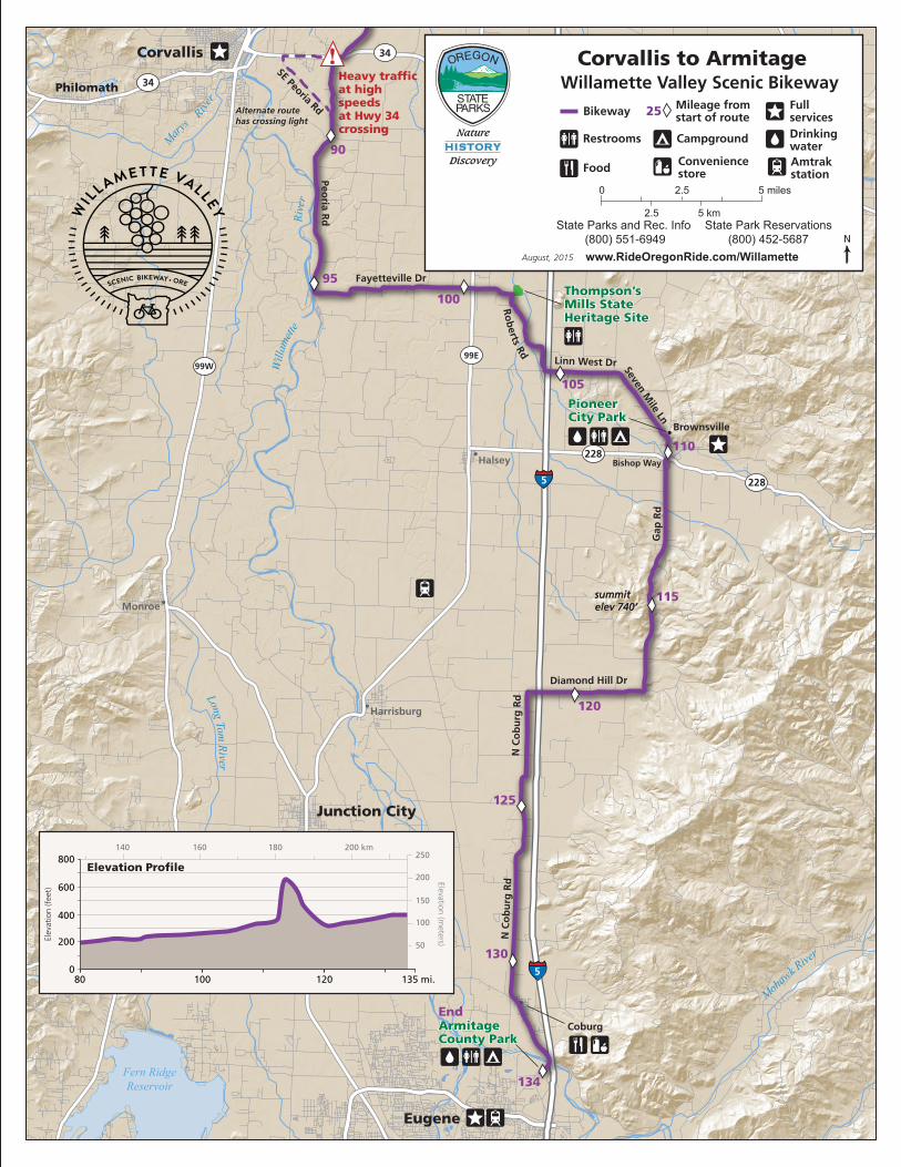
Fern RidgeReservoir
PioneerCity Park
ArmitageCounty Park
Thompson’sMills State Heritage Site
R ive
r
River
Will
amett
e
Long Tom River
Mohaw
k Rive
r
Mary
s
Diamond Hill Dr
Gap
Rd
Seven Mile Ln
Linn West Dr
Fayetteville Dr
Peoria R
d
SE Peoria Rd
N C
ob
urg
Rd
N C
ob
urg
Rd
summitelev 740’summitelev 740’
Ro
berts Rd
Corvallis
Philomath
Lebanon
Junction City
Eugene
Tangent
Brownsville
Halsey Bishop Way
Monroe
Harrisburg
Coburg
Sodaville
Heavy traffic at high speedsat Hwy 34 crossing
85
90
95
100
105
110
115
120
125
130
134
End
Alternate route has crossing lightAlternate route has crossing light
5
5
5
99E99W
34
34
228
228
!
X
X
X X
X
X
X
X
X
X
X
400
600
200
800
80 100 120 135 mi.0
Elevation Profile
Elev
atio
n (f
eet)
Elevation (meters)
200 km140 160 180
100
150
200
250
50
Corvallis to Armitage
State Parks and Rec. Info (800) 551-6949www.RideOregonRide.com/Willamette
State Park Reservations(800) 452-5687 N
Mileage fromstart of route
Restrooms
Food
Drinking water
25
August, 2015
Fullservices Bikeway X
Willamette Valley Scenic Bikeway
Campground
0 5 miles2.5
2.5 5 km
Conveniencestore
Amtrakstation
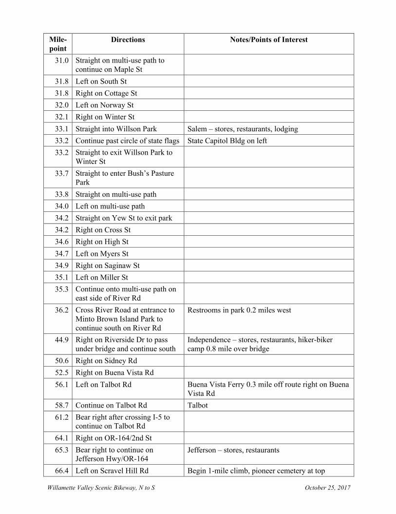
Willamette Valley Scenic Bikeway, N to S October 25, 2017
Willamette Valley Scenic Bikeway
(Champoeg State Park start, N to S)
Mile- point
Directions Notes/Points of Interest
0.0 East on Champoeg Rd from park entrance
Scenic Bikeway starts at the entrance to Champoeg State Heritage Area, water and camping available in park
0.9 Bear right on Case Rd Butteville Store 2.4 miles off route east (left) 2.3 Straight on Case Rd at
McKay/Yergen Rds CAUTION: High speed cross traffic
4.4 Right on St Paul Hwy 4.9 Left on Arbor Grove Rd 8.0 Left on OR-219 (signs for
Woodburn) CAUTION: High speed cross traffic. Two confusing intersections in a row. Continue in a southerly direction.
8.2 Right on Arbor Grove Rd/Deconinck Rd/Manning Rd
12.2 Right on Keene Rd 13.4 Left on River Rd 14.9 Right on Matheny Rd 18.1 Straight on Wheatland Rd Wheatland Ferry and multi-use path entrance into
Willamette Mission State Park 0.5 miles west (right on Matheny Rd)
18.9 Straight at Willamette Mission State Park entrance.
Water, restrooms, hiker-biker, and group camping in park 1.2 miles from entrance
21.7 Right on Ravena Dr CAUTION: This turn is easy to miss. Look for downhill.
22.8 Left on Salmon St/9th Ave/Simon St
23.7 Left on Windsor Island Rd 28.2 Straight on Shoreline Dr 28.9 Left on Manbrin Dr 29.4 Right on Cherry Ave Keizer – stores, restaurants, lodging 30.7 Right on Auto Group Ave 30.9 Left on Maple St
Willamette Valley Scenic Bikeway, N to S October 25, 2017
Mile- point
Directions Notes/Points of Interest
31.0 Straight on multi-use path to continue on Maple St
31.8 Left on South St 31.8 Right on Cottage St 32.0 Left on Norway St 32.1 Right on Winter St 33.1 Straight into Willson Park Salem – stores, restaurants, lodging 33.2 Continue past circle of state flags State Capitol Bldg on left 33.2 Straight to exit Willson Park to
Winter St
33.7 Straight to enter Bush’s Pasture Park
33.8 Straight on multi-use path 34.0 Left on multi-use path 34.2 Straight on Yew St to exit park 34.2 Right on Cross St 34.6 Right on High St 34.7 Left on Myers St 34.9 Right on Saginaw St 35.1 Left on Miller St 35.3 Continue onto multi-use path on
east side of River Rd
36.2 Cross River Road at entrance to Minto Brown Island Park to continue south on River Rd
Restrooms in park 0.2 miles west
44.9 Right on Riverside Dr to pass under bridge and continue south
Independence – stores, restaurants, hiker-biker camp 0.8 mile over bridge
50.6 Right on Sidney Rd 52.5 Right on Buena Vista Rd 56.1 Left on Talbot Rd Buena Vista Ferry 0.3 mile off route right on Buena
Vista Rd 58.7 Continue on Talbot Rd Talbot 61.2 Bear right after crossing I-5 to
continue on Talbot Rd
64.1 Right on OR-164/2nd St 65.3 Bear right to continue on
Jefferson Hwy/OR-164 Jefferson – stores, restaurants
66.4 Left on Scravel Hill Rd Begin 1-mile climb, pioneer cemetery at top
Willamette Valley Scenic Bikeway, N to S October 25, 2017
Mile- point
Directions Notes/Points of Interest
72.2 Right on US-20 CAUTION: High speed traffic, prepare for immediate left turn
72.3 Left on Kennel Rd 74.0 Right on Grand Prairie Rd 76.4 Right on Geary St 78.0 Left on 1st Ave/Calapooia St 79.4 Right on 3rd Ave Albany – stores, restaurants, lodging 79.6 Left on Bryant Way 80.7 Left on Bryant Dr 81.7 Left to continue on Bryant Dr 82.1 Right on Riverside Dr 87.4 Right on OR-34 87.6 Left on White Oak Rd If uncomfortable crossing OR-34, continue 1.6 mile
to traffic light at Peoria Rd, turn left and rejoin route at mile point 87.9
89.4 Left on Peoria Rd 95.4 Left on Fayetteville Dr
100.5 Continue onto Boston Mill Rd 101.7 Right on Roberts Rd Thompson Mills State Heritage Site 0.3 mile on
Boston Mill Rd 104.7 Left on Linn W Dr 106.9 Straight on 7 Mile Ln 109.4 Left on Depot Ave 109.5 Right on Main St Brownsville – stores, restaurants, lodging 109.7 Left on Stanard Ave 109.8 Right on Main St 110.3 Right on OR-228 110.4 Left on Washburn St/Gap Rd 114.4 Continue on Gap Rd Elevation 740 feet – highest point on Willamette
Valley Scenic Bikeway 118.4 Straight on Diamond Hill Dr 121.5 L on Coburg Rd 131.3 Left on Van Duyn St 131.5 Right on Willamette St Coburg – stores, restaurants 134.1 End of Scenic Bikeway Scenic Bikeway ends at Armitage County Park
Willamette Valley Scenic Bikeway, Armitage start October 25, 2017
Willamette Valley Scenic Bikeway
(Armitage County Park start, S to N)
Mile- point
Directions Notes/Points of Interest
0.0 North on Coburg Rd from park entrance
Scenic Bikeway starts at the entrance to Armitage County Park
2.2 Continue on Willamette St Coburg – stores, restaurants 2.7 Left on Van Duyn St 2.9 Right on Coburg Rd
12.7 Right on Diamond Hill Dr 15.7 Continue onto Gap Rd 19.7 Continue on Gap Rd Elevation 740 feet – highest point on Willamette
Valley Scenic Bikeway 23.4 Continue onto Washburn St 23.8 Right on Bishop Wy/Halsey-
Sweet Home Hwy
23.9 Left on Main St 24.4 Left on Stanard Ave Brownsville – stores, restaurants, lodging 24.4 Right on Main St 24.6 Left on Depot Ave 24.7 Bear right on Linn Way 25.2 Continue onto 7 Mile Ln 27.2 Straight onto Linn Dr 29.5 Right on Roberts Rd 32.4 Left on Boston Mill Rd Thompson Mills State Heritage Site right 0.3 mile
on Boston Mill Rd 33.7 Continue onto Fayetteville Dr 38.8 Right on Peoria Rd 44.7 Right on White Oak Rd 46.5 Right on OR-34 46.8 Left on Riverside Dr Exercise caution crossing OR-34 52.1 Left on Bryant Dr 53.4 Right on Bryant Way 54.6 Bear right to continue on Bryant
Way
Willamette Valley Scenic Bikeway, Armitage start October 25, 2017
Mile- point
Directions Notes/Points of Interest
54.7 Bear left on 3rd Ave 54.7 Left on Calapooia St 54.8 Right on 2nd Ave Albany – stores, restaurants, lodging 55.7 Left on Main St 55.8 Right on 1st Ave 56.2 Right on Geary St 57.8 Left on Grand Prairie Rd 60.2 Left on Kennel Rd 61.9 Right on US-20 CAUTION: High speed traffic, prepare for
immediate left turn 62.0 Left on Scravel Hill Rd 67.7 Right on OR-164/Jefferson Hwy 68.9 Continue on OR-164/2nd St Jefferson – stores, restaurants 70.1 Left on Talbot Rd 73.0 Bear left to continue over I-5 on
Talbot Rd
75.5 Continue on Talbot Rd Talbot 78.1 Right on Buena Vista Rd Buena Vista Ferry 0.3 mile off route left on Buena
Vista Rd 81.7 Left on Sidney Rd 83.6 Left on Riverside Dr 89.1 Right on River Rd Independence – stores, restaurants, hiker-biker
camp 0.8 mile off route over bridge 97.9 Bear right onto multi-use path at
Minto Brown Island Park Restrooms in park 0.2 mile west
98.8 Right on multi-use path to Miller St
99.0 Right on Saginaw St 99.2 Left on Myers St 99.4 Right on High St 99.5 Left on Cross St 99.9 Left on Yew St 99.9 Straight onto multi-use path
100.1 Bear right on multi-use path 100.4 Straight to exit park onto Winter
St
100.9 Straight into Willson Park 100.9 Continue past circle of state flags State Capitol Bldg on right
Willamette Valley Scenic Bikeway, Armitage start October 25, 2017
Mile- point
Directions Notes/Points of Interest
101.0 Straight to exit Willson Park onto Winter St
Salem – stores, restaurants, lodging
102.0 Left on Norway St 102.1 Right on Cottage St 102.3 Left on South St 102.3 Right on Maple Ave 103.1 Straight on multi-use path to
continue on Maple St
103.2 Right on Auto Group Ave 103.5 Left on Cherry Ave 104.7 Left on Manbrin Dr Keizer – stores, restaurants, lodging 105.2 Right on Shoreline Dr 106.0 Straight on Windsor Island Rd 110.4 Right on Simon St/9th
Ave/Salmon St
111.3 Right on Ravena Dr 112.3 Bear left on Ravena Dr 112.5 Left on Wheatland Rd 115.3 Straight at Willamette Mission
State Park entrance Water, restrooms, hiker-biker, and group camping in park 1.2 miles from entrance
116.1 Straight on Matheny Rd Wheatland Ferry 0.5 mile west (left on Matheny Rd
119.2 Left on River Rd 120.7 Right on Keene Rd 122.0 Left on Manning Rd 124.2 Bear right on Deconinck Rd/Arbor
Grove Rd
126.0 Left on OR-219 (signs for St Paul) CAUTION: High speed cross traffic. Two confusing intersections in a row. Continue in a northerly direction.
126.1 Right on Arbor Grove Rd 129.2 Right on St Paul Hwy 129.8 Left on Case Rd 131.9 Straight on Case Rd at
McKay/Yergen Rds CAUTION: High speed cross traffic
133.2 Bear left on Champoeg Rd Butteville Store 2.4 miles off route east (right) 134.1 Entrance to Champoeg State
Heritage Area Scenic Bikeway ends at Champoeg State Heritage Area, water and hiker-biker camp available in park