160
HARYANA SERIES-07 PART XII-B DISTRICT CENSUS HANDBOOK VILLAGE AND TOWN WISE PRIMARY CENSUS ABSTRACT (PCA) MEWAT DIRECTORATE OF CENSUS OPERATIONS HARYANA Census of India 2011
HARYANA
SERIES-07 PART XII-B
DISTRICT CENSUS HANDBOOK
VILLAGE AND TOWN WISE
PRIMARY CENSUS ABSTRACT (PCA)
MEWAT
DIRECTORATE OF CENSUS OPERATIONS
HARYANA
Census of India 2011

CENSUS OF INDIA 2011 HARYANA
SERIES-07 PART XII - B
DISTRICT CENSUS HANDBOOK
MEWAT
VILLAGE AND TOWN WISE
PRIMARY CENSUS ABSTRACT (PCA)
Directorate of Census Operations HARYANA
Motif
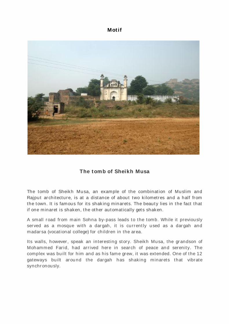
The tomb of Sheikh Musa
The tomb of Sheikh Musa, an example of the combination of Muslim and Rajput architecture, is at a distance of about two kilometres and a half from the town. It is famous for its shaking minarets. The beauty lies in the fact that if one minaret is shaken, the other automatically gets shaken.
A small road from main Sohna by-pass leads to the tomb. While it previously served as a mosque with a dargah, it is currently used as a dargah and madarsa (vocational college) for children in the area.
Its walls, however, speak an interesting story. Sheikh Musa, the grandson of Mohammed Farid, had arrived here in search of peace and serenity. The complex was built for him and as his fame grew, it was extended. One of the 12 gateways built around the dargah has shaking minarets that vibrate synchronously.
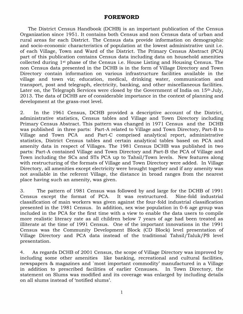
Pages
1 1
2 3
3 4
4 5
5 7
6 14
7 17
8 18
9
(i) 22
(ii) 27
(iii) 35
(iv) 43
(v) 51
(vi) 53
(vii) 121
10 Section –II Tables based on Households Amenities and Assets (Rural/Urban) at District and Sub-District level.
(i) Table -1: Households by Ownership status and by Number of Dwellingrooms occupied in the District, 2011 137
Urban PCA-Town wise Primary Census Abstract
Section - I Primary Census Abstract (PCA)
Brief note on Primary Census Abstract
District Primary Census Abstract
Appendix to District Primary Census Abstract Total, Scheduled Castes andScheduled Tribes Population - Urban Block wise
Primary Census Abstract for Scheduled Castes (SC)
Primary Census Abstract for Scheduled Tribes (ST)
Rural PCA-C.D. blocks wise Village Primary Census Abstract
Contents
Administrative Setup
Important Statistics
District Highlights - 2011 Census
Brief History of the District
Foreword
Preface
Acknowledgement
History and Scope of the District Census Handbook
(ii) Table -2: Percentage distribution of Households living in Permanent,Semi permanent and Temporary houses, 2011 138
(iii) Table -3: Number and Percentage of Households by main source ofDrinking water, 2011 140
(iv) Table -4: Number and Percentage of Households by main source ofLighting, 2011 142
(v) Table -5: Number and Percentage of Households by type of Latrinefacility, 2011 144
(vi) Table -6: Number and Percentage of Households by type of Drainageconnectivity for waste water outlet, 2011 146
(vii) Table -7: Number and Percentage of Households by availability ofKitchen facility, 2011 147
(viii) Table -8: Number and Percentage of Households by type of fuel used forCooking, 2011 148
(ix) Table -9:Number and Percentage of Households availing Bankingservices and number of Households having each of thespecified Assets, 2011
150
1
FOREWORD
The District Census Handbook (DCHB) is an important publication of the CensusOrganization since 1951. It contains both Census and non Census data of urban and
rural areas for each District. The Census data provide information on demographic and socio-economic characteristics of population at the lowest administrative unit i.e.
of each Village, Town and Ward of the District. The Primary Census Abstract (PCA) part of this publication contains Census data including data on household amenities collected during 1st phase of the Census i.e. House Listing and Housing Census. The
non Census data presented in the DCHB is in the form of Village Directory and Town Directory contain information on various infrastructure facilities available in the
village and town viz; education, medical, drinking water, communication and transport, post and telegraph, electricity, banking, and other miscellaneous facilities. Later on, the Telegraph Services were closed by the Government of India on 15th July,
2013. The data of DCHB are of considerable importance in the context of planning and development at the grass-root level.
2. In the 1961 Census, DCHB provided a descriptive account of the District,administrative statistics, Census tables and Village and Town Directory including
Primary Census Abstract. This pattern was changed in 1971 Census and the DCHB was published in three parts: Part-A related to Village and Town Directory, Part-B to Village and Town PCA and Part-C comprised analytical report, administrative
statistics, District Census tables and certain analytical tables based on PCA and amenity data in respect of Villages. The 1981 Census DCHB was published in two parts: Part-A contained Village and Town Directory and Part-B the PCA of Village and
Town including the SCs and STs PCA up to Tahsil/Town levels. New features along with restructuring of the formats of Village and Town Directory were added. In Village
Directory, all amenities except electricity were brought together and if any amenity was not available in the referent Village, the distance in broad ranges from the nearest place having such an amenity, was given.
3. The pattern of 1981 Census was followed by and large for the DCHB of 1991
Census except the format of PCA. It was restructured. Nine-fold industrial classification of main workers was given against the four-fold industrial classification presented in the 1981 Census. In addition, sex wise population in 0-6 age group was
included in the PCA for the first time with a view to enable the data users to compile more realistic literacy rate as all children below 7 years of age had been treated as illiterate at the time of 1991 Census. One of the important innovations in the 1991
Census was the Community Development Block (CD Block) level presentation of Village Directory and PCA data instead of the traditional Tahsil/Taluk/PS level
presentation.
4. As regards DCHB of 2001 Census, the scope of Village Directory was improved by
including some other amenities like banking, recreational and cultural facilities, newspapers & magazines and `most important commodity’ manufactured in a Village
in addition to prescribed facilities of earlier Censuses. In Town Directory, the statement on Slums was modified and its coverage was enlarged by including details on all slums instead of ‘notified slums’.
2
5. The scope and coverage of Village Directory of 2011 DCHB has been widened by
including a number of new amenities in addition to those of 2001. These newly added amenities are: Pre-Primary School, Engineering College, Medical College, Management Institute, Polytechnic, Non-formal Training Centre, Special School
for Disabled, Community Health Centre, Veterinary Hospital, Mobile Health Clinic, Medical Practitioner with MBBS Degree, Medical Practitioner with no degree, Traditional Practitioner and faith Healer, Medicine Shop, Community Toilet, Rural
Sanitary Mart or Sanitary Hardware Outlet in the Village, Community Bio- gas, Sub Post Office, Village Pin Code, Public Call Office, Mobile Phone Coverage, Internet
Cafes/ Common Service Centre, Private Courier Facility, Auto/Modified Autos, Taxis and Vans, Tractors, Cycle-pulled Rickshaws, Carts driven by Animals, Village connected to National Highway, State Highway, Major District Road, and Other
District Road, Availability of Water Bounded Macadam Roads in Village, ATM, Self-Help Group, Public Distribution System(PDS) Shop, Mandis/Regular Market, Weekly
Haat, Agricultural Marketing Society, Nutritional Centers (ICDS), Anganwadi Centre, ASHA (Accredited Social Health Activist), Sports Field, Public Library, Public Reading Room, Assembly Polling station, Birth & Death Registration Office. In the Town
Directory, seven Statements containing the details and the data of each Town have been presented viz.; (i)-Status and Growth History of Towns,(ii)- Physical Aspects and Location of Towns, (iii)-Civic and other Amenities, (iv)-Medical Facilities, (v)-
Educational, Recreational & Cultural Facilities, (vi)- Industry & Banking, and (vii)- Civic & other amenities in Slums respectively. CD Block wise data of Village Directory
and Village PCA have been presented in DCHB of 2011 Census as presented in earlier Census.
6. The data of DCHB 2011 Census have been presented in two parts, Part-A
contains Village and Town Directory and Part-B contains Village and Town wise Primary Census Abstract. Both the Parts have been published in separate volumes in 2011 Census.
7. The Village and Town level amenities data have been collected, compiled andcomputerized under the supervision of Smt. Neerja Sekhar, IAS, Director of Census Operation, Haryana. The task of Planning, Designing and Co-ordination of this
publication was carried out by Dr. Pratibha Kumari, Assistant Registrar General (SS) under the guidance & supervision of Dr. R.C.Sethi, Ex-Addl. RGI and Shri Deepak
Rastogi present Addl.RGI. Shri A.P. Singh, Deputy Registrar General, (Map) provided the technical guidance in the preparation of maps. Shri A.K. Arora, Joint Director of Data Processing Division under the overall supervision of Shri M.S.Thapa, Addl.
Director (EDP) provided full cooperation in preparation of record structure for digitization and validity checking of Village and Town Directory data and the
programme for the generation of Village Directory and Town Directory including various analytical inset tables as well as Primary Census Abstract (PCA). The work of preparation of DCHB, 2011 Census has been monitored in the Social Studies Division.
I am thankful to all of them and others who have contributed to bring out this publication in time.
New Delhi. (C.Chandramouli) Dated:- 16-06-2014 Registrar General &
Census Commissioner, India
3
Preface The District Census Handbook (DCHB) is one of the important and
most valuable publications of Census Organisation which is brought out for each district. It contains several demographic and socio-economic characteristics village-wise and town-wise of the district along with the status of availability of civic amenities, infrastructural facilities etc.
DCHB reflects an overview of the district and is widely used by administrators, planners, academicians, researchers, various departments and general public. For DCHB publication, population data was taken from Census 2011, whereas non-census data was collected with the active collaboration of State Govt.
The Census 2011 was conducted under the able guidance of Dr. C. Chandramouli, IAS, Registrar General & Census Commissioner, India. The credit of the successful accomplishment of this huge task goes to him for his tremendous and spontaneous work. On behalf of this Directorate I am highly grateful to him and also extend my thanks to Sh. Deepak Rastogi, Additional Registrar General for timely guidance. I extend my thanks to Dr. Pratibha Kumari, Assistant Registrar General (Social Studies), under whose guidance this publication was finalised. Further I extend my special thanks to Sh. A. P. Singh, Deputy Registrar General (MAP) and Sh. A.K. Arora, Joint Director, EDP, who took great pains in bringing out this publication.
I am very grateful on behalf of this Directorate to Smt. Neerja Sekhar, IAS, the then Director under whose able guidance the specified task was mostly completed and I would like to acknowledge all the staff members of DCO Haryana, particularly the team headed by Sh. Vinod Kumar Babbar, DDCO, Sh. B.V.L. Sai Sekhar, the then ADCO and the entire team of DCO Haryana. Lastly I record my appreciation for the best efforts put in by the staff of DCHB, Map and Census Sections.
I hope this publication will provide more useful information for all the data users.
Chandigarh G. Bapuji 18-06-2014 JDCO, Haryana.
4
Acknowledgement
Drafting of DCHB Sh. Amarjit Singh Toor Assistant Director (Retd.) Ms. Kavita Panchal St. Investigator Gr. II
Editing and Scrutiny of DCHB Sh. Vinod Kumar Babbar Deputy Director
Finalisation of DCHB Sh. G. Bapuji Joint Director
DCHB Section Ms. Kavita Panchal St. Investigator Gr. II Sh. Amrit Lal St. Investigator Gr. II Sh. Lekh Raj St. Investigator Gr. II Sh. Nagesh Kumar Seth (Retd.) St. Investigator Gr. II Sh. R.K. Yadav (Retd.) St. Investigator Gr. II Ms. Anju Sem Senior Drawing Assistant Ms. Rashmi Saini Compiler
Map Section Sh. Tej Pal Singh Research Officer Dr. Radha Raman Senior Geographer Sh. Vidya Sagar Senior Draftsman Ms. Neelam Lakhanpal Senior Draftsman Sh. Ashwani Kumar Senior Draftsman Sh. Gautam Kumar Roy Senior Draftsman
Printing Section Sh. K.M. Deshmukh Proof Reader
Others associated with the Project Sh. Om Prakash St. Investigator Gr. II Ms. Raksha Devi Sr. Compiler Ms. Ram Dasso Compiler Ms. Pinki L.D.C.
ORGI- Data Processing Division Sh. Jaspal Singh Lamba Deputy Director (EDP) Ms. Usha Assistant Director (EDP) Sh. Anurag Gupta DPA Grade ‘A’ Sh. Mukesh Kumar Mahawar DPA Grade ‘A’ Ms. Shagufta Nasreen Bhat DPA Grade ‘A’ Ms. Shashi Seth Sr. Supervisor Sh. Khem Verma Jadon Sr. Consultant Sh. Yashwant Singh Jr. Consultant
5
HISTORY AND SCOPE OF THE DISTRICT CENSUS HANDBOOK
The need of data at the grass root level for the administrative and planning purposes at sub micro level as well as academic studies prompted the innovation of District Census Handbook. District Census Handbook is
a unique publication from the Census organization which provides most authentic details of census and non-census information from village and town level to district level. The District Census Handbook was firstly
introduced during the 1951 Census. It contains both census and non census data of urban as well as rural areas for each district. The census
data contain several demographic and socio-economic characteristics of the lowest administrative unit i.e. of each village and town and ward of the district. The non census data comprise of data on availability of various
civic amenities and infrastructural facilities etc. at the town and village level which constitute Village Directory and Town Directory part of the
DCHB. The data of DCHB are of considerable importance in the context of planning and development at grass-root level.
In 1961 census DCHB provided a descriptive account of the district, administrative statistics, census tables and village and town directory including Primary Census Abstract. This pattern was changed in 1971
Census and the DCHB was published in three parts: Part-A related to village and town directory, Part-B to village and town PCA and Part-C
comprised analytical report, administrative statistics, district census tables and certain analytical tables based on PCA and amenity data in respect of villages. The 1981 census DCHB was published in two parts: Part-A
contained village and town directory and Part-B the PCA of village and town including the SCs and STs PCA up to tahsil/town levels. New features
along with restructuring of the formats of village and town directory were added into it. In Village Directory, all amenities except electricity were brought together and if any amenity was not available in the referent
village, the distance in broad ranges from the nearest place having such an amenity, was given.
The pattern of 1981 census was followed by and large for the DCHB of 1991 Census except the format of PCA. It was restructured. Nine-fold
industrial classification of main workers was given against the four-fold industrial classification presented in the 1981 census. In addition, sex wise population in 0-6 age group was included in the PCA for the first time
with a view to enable the data users to compile more realistic literacy rate as all children below 7 years of age had been treated as illiterate at the time of 1991 census. One of the important innovations in the 1991 census was
the Community Development Block (CD Block) level presentation of village directory and PCA data instead of the traditional tahsil/taluk/PS level
presentation.
6
As regards DCHB of 2001 Census, the scope of Village Directory was improved by including some other amenities like banking, recreational and
cultural facilities, newspapers & magazines and `most important commodity’ manufactured in a village in addition to prescribed facilities of earlier censuses. In Town Directory, the statement on Slums was modified
and its coverage was enlarged by including details on all slums instead of ‘notified slums’.
The scope and coverage of Village Directory of 2011 DCHB has been widened by including a number of new amenities in addition to those of
2001. In the Town Directory, seven Statements containing the details and the data of each town have been presented viz.; (i)-Status and Growth History of towns,(ii)- Physical Aspects and Location of Towns, (iii)-Civic and
other Amenities, (iv)-Medical Facilities, (v)-Educational, Recreational & Cultural Facilities, (vi)- Industry & Banking, and (vii)- Civic & other
amenities in Slums respectively. CD Block wise data of Village Directory and Village PCA have been presented in DCHB of 2011 census as presented in earlier census. The data of DCHB 2011 Census have been presented in
two parts, Part-A contains Village and Town Directory and Part-B contains Village and Town wise Primary Census Abstract. Both the Parts have been published in separate volumes in 2011 Census.
--------------------------------------------------------
7
Brief History of the District
Nothing much is known about the ancient history of the areas comprising Mewat district but it seems always to have been held under the sway of the rulers of Delhi.The Bhadanakas obviously connected with the ancient Bhadras are referred to in the Mahabharata as a republic or oligarchy which karna conquered in course of his expeditions. These Bhadanakas can be located in Rewari-Bhiwani region where Bhadavasa,a village 8 kilometer to the south of Rewari, seems to attest their existence.
It can be assumed on the basis of the extent of the Maurya Empire that the region was held under effective Maurya control. After the break-up of the Maurya Empire, inroads of the foreign invaders, like the Bactrians, Greeks, Parthians, Scythians and Kushanas, spread confusion in the region.But soon the Yaudheyas rose up and repelled the rule of the Kushanas from the region between the Satluj and the Yamuna. They were first subdued by the mighty Saka Satrap Rudradaman, then by Samudragupta, later by the Hunas who were overthrown by YasodharmanVishnuvardhana of Mandasor, and lastly by Yashovarman, the kings of Kanauj.
The area of Mewat also formed a part of Harsha’s empire in the first half of the seventh century, and then of the Gurjara- Pratiharas. The Tomaras who were earlier the feudatories of the Pratiharas and later became independent, laid the foundation of Delhi, then called Dhillika in A.D. 736 and the Gurgaon-Mewat region was under them till VisaladevaChahamana conquered Delhi about A.D. 1156. The country of Bhadanakas, and a part of the old Alwar State was invaded by PrithvirajaChauhan (Chahamana) sometime before A.D.1182. the chief of the Bhadanakas, resisted the Chauhan (Chahamana) King with his powerful elephants but was severely defeated.
During the early Muslim invasion, the people of the region would appear to have experienced vicissitudes of fortune at the hands of the incoming Muslim invaders. Their resilience in fighting for their political independence was as remarkable as their adhesion to their earlier way of life even after their conversion to the religion of the rulers of Delhi. The history is replete with struggles between the central power at Delhi and its difficult and recalcitrant neighbors to the south. For nearly two centuries the people of the region sturdily resisted the Muslim domination and the history of the region is a record of incursions of the people of Mewat area which included district of Gurgaon, Mathura (UP) and parts of former States of Alwar and Bharatpur (Rajasthan) into Delhi territory and of punitive expeditions undertaken against them. The region was finally subdued after the defeat of PrithvirajaChahamana by Muzz-ud-din Muhammad Ghuri in A.D. 1192. In the reign of Qutb-ud-din Aibak (A.D.1200-1210), Hemraj, son of Prithviraja, invaded the mewat from Alwar, but he was defeated and slain. Aibak
8
then dispatched SayyidWajih-ud-din who was slain and it was reserved for his nephew MiranHussain Jang to subdue the Meos, who agreed to pay jazia, while some accepted Islam.
Mewat was again turbulent following the death of Shams-ud-din Iltutamish in A.D.1236. However, the Meos of the Gurgaon district attracted much attention under the rule of Ghias-ud-din Balban, first as the prime minister of Nasir-ud-din Mahmud who ruled from A.D.1246 to 1266 and later as Emperor employed in chastising the people of Mewat. In this campaign, about two thousand Meos were killed. During the Mongol invasion of Punjab in A.D. 1257-58, the Meos were again in revolt and carried off a large number of Balban’s camels, without which the army could hardly have taken the field.
The struggle against the Meos continued. Balban inflicted a crushing defeat upon them in A.D. 1260 in spite of these invasions and slaughter of the population en masse, it appears that during the period of early Muslim rule, the area known as Mewat was never permanently conquered.
The depredations of Meos extended at times to the walls of Delhi and beyond the Yamuna into the Doab. Subsequent events even support the view that the various claimants to political power in Delhi took refuge in and sought help from the chieftains of Mewat. Thus Khan Jahan, the powerful and cunning minister of Firoz Shah Tughlaq (A.D.1351-1388), having failed in his scheme to capture the throne, fled to Mewat, seeking shelter with its chief KokaChauhan, but he was seized and killed. This happened about the year A.D.1387. during the reign of the feeble successors of Firuz Shah, the nominal allegiance of Mewat was transferred from one prince to another. The caprice of the local chieftains determined how their own interests would be served in the long run. The depredations of the Meas again extended across the Yamuna into the Doab, and northward even into the streets of Delhi. BahadurNahar, whose tomb still stands at Alwar and who ruled Mewat at the time of Timur’s invasion at the end of the 14th century, was one of the most powerful Meo chiefs in the neighborhood of Delhi. He belonged to the jadu Got of the Meos. His original name is said to be Sambar Pal. When he killed a tiger by his sword, Firuz Shah Tuglaq gave him the title of ‘BahadurNahar’. He was given a jagir in the Mewat area where he built a fort known as Kotla Bahadur Nahar. He embraced Islam and so did some other Meo chiefs of his caste and they become known as Khanzadas. Kotla Bahadur Nahar is now village Kotala on the Kotla Jhil.
On his expulsion from the governorship of Multan in 1395, Khizr Khan, the founder of the Sayyid dynasty, had also taken shelter in Mewat. Later, he made his submission to Timur and was left by him as his viceroy at Lahore. In December 1413, Khir Khan won the support of jalal Khan who had succeeded BahadurNahar. Having defeated Daulat khan Lodi, he entered Delhi in triumph
9
on june 6, 1414, but his hold beyond Delhi extended only over Mewat and a portion of the Doab.
In 1421, the last year of his reign, Khizr Khan marched into Mewat to assert his authority in that province, captured and destroyed kotla, the former stronghold of BahadurNahar, and received the submission of most of the inhabitants. Khizr Khan was succeeded by his son Mubarak Shah (A.D.1421-1434) whose interests over Mewat clashed with those of Ibrahim, the Sharqi ruler of Jaunpur, who had become very powerful and ambitious.
Almost throughout Mubarak’s reign, Mewat remained unsettled and rebellious. The Sultan marched into Mewat towards the close of the year 1424 with the object of crushing an insurrection there, but the rebels laid waste their villages in the plains and retired into their hill fortresses. The king was obliged to return to Delhi. Next year (1425), the Mewatis rose again under their twin leaders, Jalal Khan and Abdul Qadir(or Qadr Khan), nicknamed Jallu and Qaddu, grandsons of BahadurNahar. Mubarak followed them into the hills, drove them from the stronghold of Andur which he dismantled and pursued them to Alwar where the surrendered. Jallu escaped but Qaddu was arrested and carried as a prisoner to Delhi and after some time was put to death on charge of conspiracy with Ibrahim Sharqi of Jaunpur.
The execution of Qaddu led to a fresh rebellion in Mewat, headed by his brother Jallu. Sarvar-ul-Mulk, the minister who was appointed to suppress it, followed the rebels into the hillsin which they had, in their time-honored way, taken refuge. He returned to Delhi on their paying empty compliments of formal submission to his master.
In November 1432, Mubarak again invaded Mewat where jallu was in revolt and drove him from one stronghold to another. Finding the security offered by his small fortress against pressure of royal troops of little value, Jallu submitted once more on the usual promise of paying tribute.
Bahlol whose reputation was greatly enhanced by his victory over Mahmud Shah of Jaunpur in A.D.1451, again marched to Mewat where he received without a battle, the submission of Ahmad Khan, who surrendered seven parganas to him, agreed ltohild the remainder of his territory as a fief of Delhi, and placed his uncle Mubarak Khan at Bahlol’scourt, nominally as his agent, but in fact as a hostage.
Ahmad Khan had no intention to be loyal. He joined hussain Shah of Jaunpur in his expedition against Delhi in A.D. 1473. Bahlol marched against him. Ahmad Khan fled and joined Hussain in Jaunpur. The Gurgaon territory passed under the direct control of the lodis, though the Khanzada chiefs were not totally suppressed.
10
At the time of Babar’s invasion, hasan Khan Khanzada was the chief of Mewat. As he declined to submit, Babar led an expedition against him. Hasan Khan was killed in A.D. 1527 and his son, Nahar Khan, submitted to the Mughal overlord ship. Mewat was made a part of the Mughal Empire and henceforward regular governors were appointed for this area.
Mewat continued to remain a part of the Delhi Empire under the Sur Dynasty. Mashad Ali Khawas Khan, one of the chief generals of Sher Shah Suri, was in Mewat at the time of the latter’s death in A.D.1545. he incurred the hostility of Islam on Salim Shah (A.D.1545-1553), the son and successor of Sher Shah, for siding with Adil Khan, in the vicinity of Agra, Khawas Khan and Isa Khan Niazi retreated to Mewat.
In the time of Akbar (A.D.1556-1605), the area covered by the Mewat district was contained in Subah of Delhi and Agra, in 1685, Aurangzeb had to send a powerful army under the command of Raja Jai Singh to Mewat area against Ikram, Khan who had started giving trouble to the Mughal administration. Heavy casualties were inflicted on his followers and the fort of Alwar was captured from the rebels.
During the period of the decline of the Mughal empire after the death of Aurangzeb, the district was torn betw3een several contending powers.
Apa Khande Rao, the Maratha governor of the Mewat country, west of Delhi, engaged George Thomas (c. October 1793) and placed a battalion of sepoys under him.
Early in the year 1794, Thomas was raising fresh troops, collecting revenue by force from the ever-refractory peasantry of Mewat, and (in April) supporting his unpaid soldiery by looting Gurgaon and two other villages in the jagir if begum Samru. As ApaKhandeRao enlarged the contingent of Thomas, he assigned to him Tijara, Tapukra and FirozpurJhirka as fiefs.
Within two-years of the abandonment of his dominion by George Thomas in 1801, the rising power of Daulat Rao Sindhia in North India was completely broken by the British forces under General Lake in the Second Maratha War. The district, with other possessions of Sindhia, west of the Yamuna, passed on to the British East India Company by the Treaty of SurjiArjungaon signed on December 30, 1803.
FirozpurJhirka and Punahana along with Loharu were granted by the Alwar Raja and the British to an agent of Alwar Raja, Ahmad Baksh Khan. His son, Nawab Shams-ud-din, was executed on account of his complicity in the murder of William Frazer, the Resident of Delhi in 1835, and the paraganas of Firozpur and Punahana were annexed by the British.
11
“In the last week of May, when almost the whole of the rural Mewat had come under the rule of emperor Bahadur Shah, the urban Mewat still owed allegiance to the British through their “native officials” and wealthy persons, on whom the favors had been showered by the government earlier. Large gatherings of Mewatis attacked such towns. They did not meet any opposition at Taoru, Sohana, FirozpurJhirka, Punahana and Pinangwan, and easily reduced them to subjection. A great deal of plundering and destruction also took place. The town of Nuh proved to be a hard nut to crack. The local police and the “Loyal Khanzadas” gave a stiff battle to the Meos. But soon they were overpowered by the superior numbers of the latter. The khanzadassuffered heavy casualties. After the khanzadas of Nuh, the RawatJats of the region near Hodal and the Rajput of Hathin, “who were supposed to be on the part of the (British) Government”, were attacked by a large gathering of Surotjats of Hodal, pathans of Seoli and the Meos. The fight continued for several months and the ‘loyalists’ suffered heavy losses. On receipt of the S.O.S. signal from the Rawats, the British authorities at Delhi dispatched a small force to Hodal to help their supporters. The loyalists and the British troops fought well, but they were completely routed by the Mewatis.
“Major Eden’s contingent force met stiff opposition at the hands of the thousands of armed men from the villages between Taoru and Sohna. Had he not been in possession of the artillery guns, his force would have experienced heavy losses. He destroyed many villages. He halted at Sohna for three days. Ford and thirty European officers came down from Mohena and joined him there. After that, his force moved towards Palwaland remained between that place and Hodal for a long time. But sickness, discontent and growing spirit of revolt among his troops obliged him to return to Jaipur in August 1857.
“The departure of Major Eden’s force led to further deterioration in the situation. Even the fall of Delhi on September 20, 1857 did not effect any improvement in the situation. Consequently, on October 2, a strong column of 1,500 men with a light field battery, a few 18-pounder guns, and 2 mortars, was sent under Brigadier-General Showers to punish the turbulent Meos, Gujars, Ranghars, Ahirs and ‘the rebel princes’; and to settle the Gurgaon district. Throughout the month of October, the Brigadier General labored hard to realize his aims. He seized the Nawabs of Jhajjar, Dadri, Farrukhnagar and the Raja of ballabgarh, dispersed their troops and took their forts. In the settlements of Mewat, his work was shared by Clifford, the Assistant Collector of Gurgaon. Clifford’s sister was “stripped naked at the palace, tied in that condition to the wheels of gun-carriages, dragged up in the ChandniChowk’ or Silver Street of Delhi and then, in the presence of King’s son, cut to pieces”. Clifford “had it on his mind that his sister, before being murdered, was outraged by the rebels” Naturally he had a fire of revenge burning violently in his heart. He burnt village after village and destroyed the countryside with. In his own words, “He had put to
12
death all he had come across, not excepting women and children. But he could not carry on his ruthless campaign for long, for he was killed by the Meos of Raisina and Muhammadpur.
“Brigadier-General Showers carried fire and sword far and wide. All the villages between Dharuhera and Taoru were indiscriminately burnt and their inhabitants were shot down ruthlessly. At the deserted town of Taoru some 30 persons were killed. A few miles short of Sohna, his column met a stiff resistance at the hands of the inmates of a Meos village who killed about 60 Sepoys of General Showers’column in a hand-to-hand fight.
“The column, having cleared the area around Sohna and Taoru and leaving it in the charge of a Gorkha detachment of the late 22 N.I. under Captain Drummond, went to Delhi via Ballabgarh. An account of his experiences in the district of Gurgaon by Brigadier-General Showers is worth noticing: “From the time I entered the Gurgaon district, I was in enemies’ country that in all encampments and during every march I was exposed to the attacks of the enemies horsemen……………. I had to anticipate attack from every village that I Passed, where I had to be continually on the alert against an enemy.
“In the third week of November 1857, Captain Drummond received intelligence through the “native officials” of Sohna, Hathin and Palwal that “several thousand Meos and a few hundred cavalry were congregated about Kot and Rupraka”and had been attacking the “loyal Rajput villages” for several days. Besides, they were also intent on plundering the Government treasury at Palwal. Captain Drummond with a small force comprising a detachment of Hodson’s Horse, another of Tohana Horse, and some 120 men of the Kumaon Battalion, at once proceeded to Rupraka. On the way, he was reinforced by a company of the Its Punjab Infantry (Coke’s) from Ballabgarh.
“Captain Drummond’s force burnt all the meo villages on the Sohna Rupraka route and destroyed their crops. Panchanka, Geopur, Malpuri, Chilli, Utawar, KotMuglaMitaka, Kululka, Guraksar,Malluka,Jhanda,etc. were among these unfortunate gillages. When the column reached Rupraka, 3,500 Meos and others drew up in front of the village, and gave them a tough fight. Though the Meos fought heroically and lost 400 men, the day went to the British who possessed superior fire power. The action at Rupraka, says Captain Drummond, was very important in the way that “not only have the Meos been defeated, their villages and property burnt and destroyed, but the friendly Jat villages who have hitherto been kept in a state of siege by constant aggression on the part of their enemies, are relieved.
“On November 27, 1857, another rebel force commanded by a Meos leader Sadar-ud-Din attacked the Pargana of Pinangwan. A British force under Captain
13
Ramsay from Palwal and Gurgaon was dispatched at once to meet the danger the force reached Pinangwan on November 29. But the rebels were then at a small village calied Mahun. They made for that village next day and reached there at 7 A.M. The Meos took the defensive in the village. Exchange of shots continued toll mid-day. Then the British troops bombarded the village with guns. Three Gorkha regiments advanced upon the village from three directions, and they seized the village in a short time. The entire village was destroyed by fire. They cut down 28 Meos in the village including Sadar-ud-din’s son, and 42 more in the neighboring villages.
“Having crushed the last of the risings in Mewat, the column effected its retreat, but not before making a clean sweep of the villages and people suspected to have taken part in the Uprising. The villages of Shahpur, Bali khera, Kherla, Chitora, Nahirika, GujarNagla, Baharpur, Kheri, etc., were set on fire and wiped out of existence. After sometime, many more villages in the neighborhood of pininghwan met the same fate for assisting the rebel leader Sadar-ud-Din and refusing to pay revenue to the British Government.
“The landed property of several of the villagers, chaudharis and lambardars was confiscated in accordance with the Acts XXV of 1857 and 1858 for their rebellious acts and failure to extend and help to the British at the time of sore need. The villaes of Jharsa, Kheri, Jalalpur, and Davela in the JharsaPargana and Shikrawah and Ghaghuskheri in the pargana of Nuh, suffered confiscation of the entire landed property of theirs. Bhaktawar Singh of jharsa and Udampur, IlahiBax of badhsahpur and Dhanuspur, Mirkhan of Naurangpur and Abu of Bhora and Binola in the JharasPargana, BrijaNand of Shahjahanpur, Ramjas and Hamza Ali of Chhajunagar, Jaffar, Nurkhan, and Ghariba of Rasulpur in the pargana of palwal got their shares of landed property confiscated. Besides that, 235 persons were hanged and many more got long term imprisonments for taking part in the rebellion. Heavy fines were imposed on the individuals and rebel villages.
By and large, during the thirties and forties of the 20th century, the Meos in the district supported the Unionist party in the Punjab. This was a party of the landed aristocracy of the Punjab who irrespective of their caste and religion championed the cause of the Zamindars as against the town dwellers. Communal tension increased in 1945-46 and this had its repercussions in the Mewat area of Gurgaon also. A branch of the All India Muslim League was established there and a large number of Meos Joined it. In the 1946 Elections to the Punjab Legislative Assembly, two Muslim Leaguers were returned as members from this area. In 1947, a scheme of organizing Mewat into a separate Meo province was mooted, and it had the sympathies of the All India Muslim League. Meanwhile, the country was partitioned and India achieved Independence on August 15, 1947.
14
Administrative set up History is replete with struggles between central power at Delhi and its
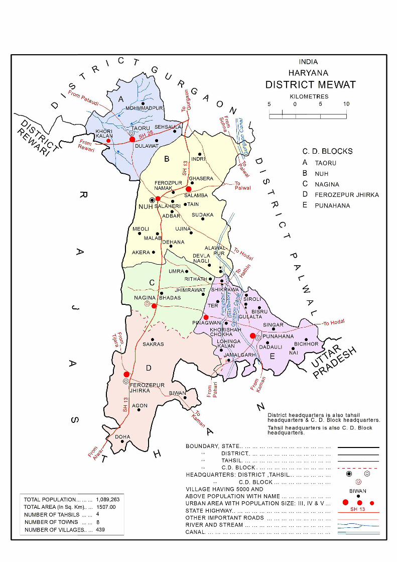
difficult and recalcitrant neighbours to the south. People of the region sturdily resisted the muslim domination for nearly two centuries and the regional history is a record of incursion of the people of Mewat area. In the Mughal period, during Akbar’s reign, the district was part of Suba of Delhi and Agra and comprised wholly or partly, the Sirkars of Delhi, Rewari, Suhar or Pahari and Tijara. In 1858, it was transferred from North Western provinces to Punjab. In 1861, there were five tahsils Gurgaon, Palwal, Nuh, Ferozepur Jhirka and Rewari. In 1950, Pataudi and 78 villages from Pepsu were merged in Gurgoan district. In 1979, the district was bifurcated into Gurgaon and Faridabad. Gurgaon district contained Pataudi, Gurgaon, Farrukhnagar, Nuh and Ferozepur Jhirka tahsils. Punahana tahsil was created in May, 1994 and Taoru tahsil was created in December, 1999. Mewat district came into existence in December 2004 with Taoru, Nuh, Ferozepur Jhirka and Punahana tahsils.
The State has been experiencing inter-district and inter-tahsil jurisdictional transfers ever since its formation on 1stNovember, 1966. There were 7 districts at the 1971 Census which increased to 12 in 1981, 16 in 1991, 19 in 2001 and 21 in 2011. Likewise the number of tahsils has increased from 32 to 74 and towns from 65 to154 in 1971and 2011 respectively.
Haryana State is divided into four administrative Divisions, namely Ambala, Rohtak, Hisar and Gurgaon, each headed by Divisional Commissioner. Ambala Division covered Panchkula, Ambala, Yamunanagar, Kurukshetra and Kaithal districts; Rohtak Division extended over Karnal, Panipat, Sonipat, Rohtak and Jhajjar districts; Hisar Division is spread over Jind, Bhiwani, Hisar, Fatehabad and Sirsa districts; Gurgaon Division is spread over Mahendragarh, Rewari, Gurgaon, Mewat, Faridabad and Palwal districts. During 2011 Census two newly created districts, namely, Mewat (17th December 2004) out of district Gurgaon and Palwal (13th August, 2008) out of district Faridabad have been added in Gurgaon Division.
The district is part of Gurgaon Division which has its headquarters at Nuh town. Two Sub Divisional offices of Nuh and Ferozepur Jhirka have been established to control administratively the tahsils of Taoru, Nuh, Ferozepur Jhirka and Punahana. Five Community Development Blocks, namely, Taoru, Nuh, Nagina, Ferozepur Jhirka and Punahana have been set up in the district for the development of rural areas.
At the time of 2011 Census, position of the district was that it contained four tahsils, namely, Taoru (81 villages and Taoru town and Khori Kalan Census Town), Nuh (118 villages and Nuh town and Salamba Census Town) Ferozepur Jhirka (145 villages and Ferozepur Jhirka town and Nagina Census Town) and Punahana (95 villages and Punahana town and Pinagwan Census Town).
15
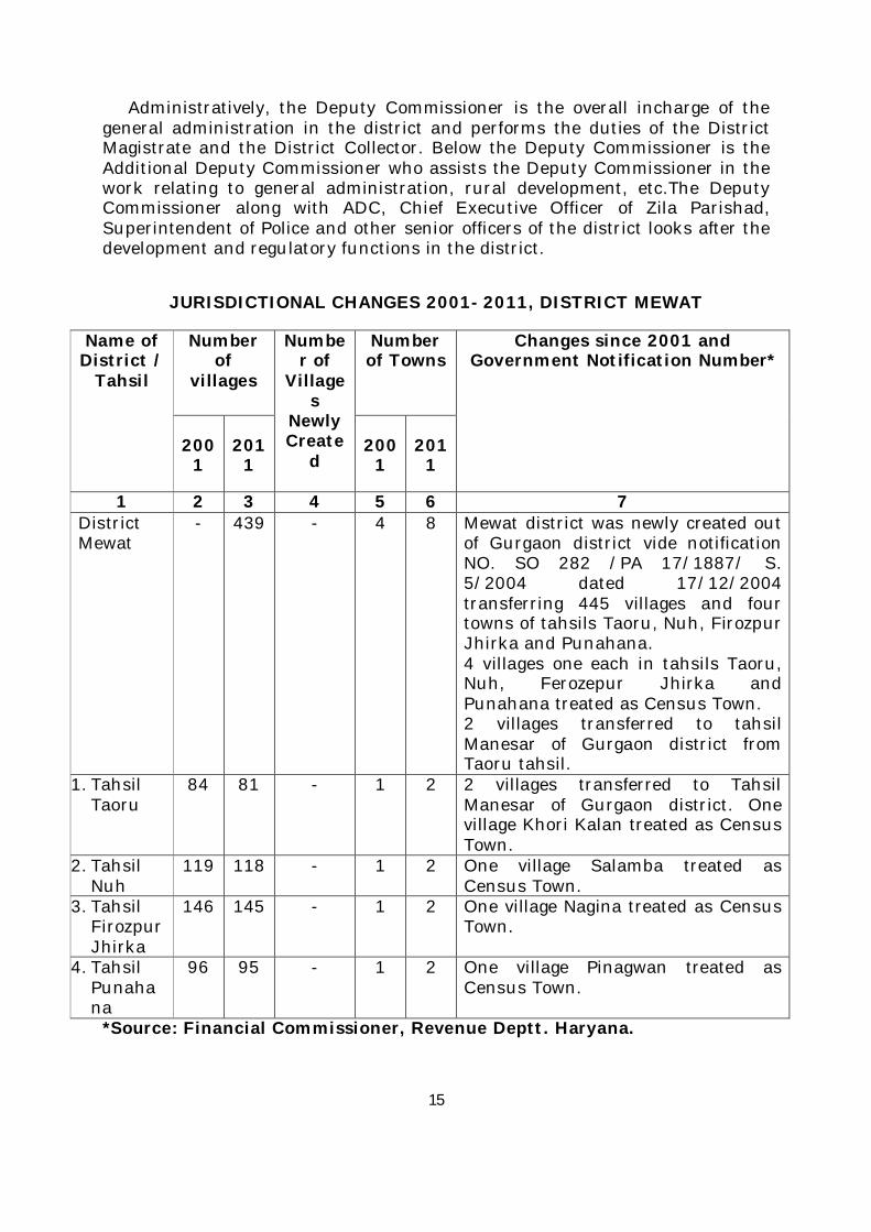
Administratively, the Deputy Commissioner is the overall incharge of the general administration in the district and performs the duties of the District Magistrate and the District Collector. Below the Deputy Commissioner is the Additional Deputy Commissioner who assists the Deputy Commissioner in the work relating to general administration, rural development, etc.The Deputy Commissioner along with ADC, Chief Executive Officer of Zila Parishad, Superintendent of Police and other senior officers of the district looks after the development and regulatory functions in the district.
JURISDICTIONAL CHANGES 2001- 2011, DISTRICT MEWAT
Name of District /
Tahsil
Number of
villages
Number of
Villages
Newly Create
d
Number of Towns
Changes since 2001 and Government Notification Number*
2001
2011
2001
2011
1 2 3 4 5 6 7 District Mewat
- 439 - 4 8 Mewat district was newly created out of Gurgaon district vide notification NO. SO 282 /PA 17/1887/ S. 5/2004 dated 17/12/2004 transferring 445 villages and four towns of tahsils Taoru, Nuh, Firozpur Jhirka and Punahana. 4 villages one each in tahsils Taoru, Nuh, Ferozepur Jhirka and Punahana treated as Census Town. 2 villages transferred to tahsil Manesar of Gurgaon district from Taoru tahsil.
1. Tahsil Taoru
84 81 - 1 2 2 villages transferred to Tahsil Manesar of Gurgaon district. One village Khori Kalan treated as Census Town.
2. Tahsil Nuh
119 118 - 1 2 One village Salamba treated as Census Town.
3. Tahsil Firozpur Jhirka
146 145 - 1 2 One village Nagina treated as Census Town.
4. Tahsil Punahana
96 95 - 1 2 One village Pinagwan treated as Census Town.
*Source: Financial Commissioner, Revenue Deptt. Haryana.
16
To decentralize the authority in the administrative set up, the district is divided into two sub-divisions, Nuh and Ferozepur Jhirka. Sub-divisions are not necessarily co-terminus with the name of their respective tahsils. Taoru tahsil is under the administrative control of Nuh Sub-Division and Punahana tahsil is under the administrative control of Ferozepur Jhirka Sub-Division. Zila Parishad and Panchayat Samitis correspond to the district and C.D. Block boundaries respectively except that the municipal areas are not covered by them.
The Zila Parishad, elects its President and Vice-President from amongst the elected members. The term of office of members is five years. An officer in the senior scale of I.A.S. is deputed by the State government as the Chief Executive Officer to the Zila Parishad. The Parishad is also assisted by various departments of the district. At the community Development Block level, each Panchayat Samiti has an elected Chairman and Vice Chairman.The Block Development and Panchayat Officer works as Executive Officer of the Panchayat Samiti. The executive authority for the purpose of carrying out the provisions of the Haryana Zila Parishad and Panchayat Samitis (C.D. Blocks) Act vests in the Chief Executive Officer and the Block Development and Panchayat Officer respectively.
The statutory urban local bodies are municipal councils, municipal committees, etc.The urban local bodies elect councilors from each of the ward and their term is five years.
Process of governance at the lowest level is Gram Panchayat which makes adequate arrangements for developmentin various fields in rural areas.
17
District Highlights 2011 Census
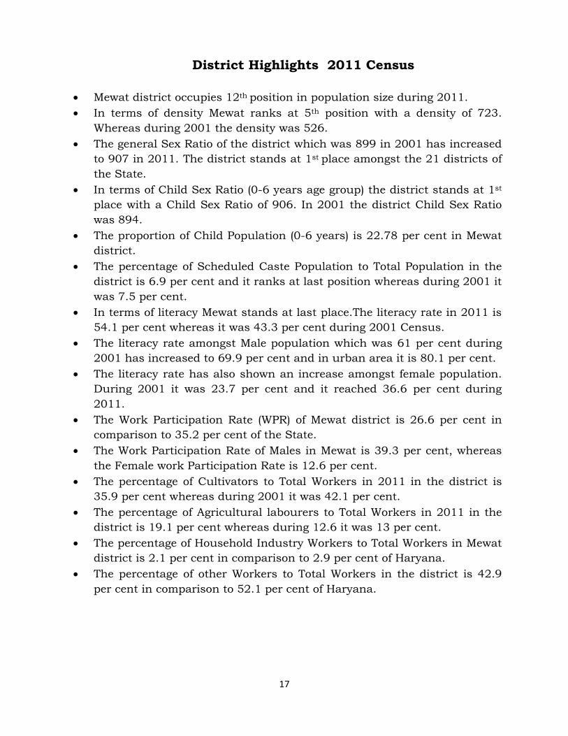
Mewat district occupies 12th position in population size during 2011.
In terms of density Mewat ranks at 5th position with a density of 723.
Whereas during 2001 the density was 526.
The general Sex Ratio of the district which was 899 in 2001 has increased
to 907 in 2011. The district stands at 1st place amongst the 21 districts of
the State.
In terms of Child Sex Ratio (0-6 years age group) the district stands at 1st
place with a Child Sex Ratio of 906. In 2001 the district Child Sex Ratio
was 894.
The proportion of Child Population (0-6 years) is 22.78 per cent in Mewat
district.
The percentage of Scheduled Caste Population to Total Population in the
district is 6.9 per cent and it ranks at last position whereas during 2001 it
was 7.5 per cent.
In terms of literacy Mewat stands at last place.The literacy rate in 2011 is
54.1 per cent whereas it was 43.3 per cent during 2001 Census.
The literacy rate amongst Male population which was 61 per cent during
2001 has increased to 69.9 per cent and in urban area it is 80.1 per cent.
The literacy rate has also shown an increase amongst female population.
During 2001 it was 23.7 per cent and it reached 36.6 per cent during
2011.
The Work Participation Rate (WPR) of Mewat district is 26.6 per cent in
comparison to 35.2 per cent of the State.
The Work Participation Rate of Males in Mewat is 39.3 per cent, whereas
the Female work Participation Rate is 12.6 per cent.
The percentage of Cultivators to Total Workers in 2011 in the district is
35.9 per cent whereas during 2001 it was 42.1 per cent.
The percentage of Agricultural labourers to Total Workers in 2011 in the
district is 19.1 per cent whereas during 12.6 it was 13 per cent.
The percentage of Household Industry Workers to Total Workers in Mewat
district is 2.1 per cent in comparison to 2.9 per cent of Haryana.
The percentage of other Workers to Total Workers in the district is 42.9
per cent in comparison to 52.1 per cent of Haryana.
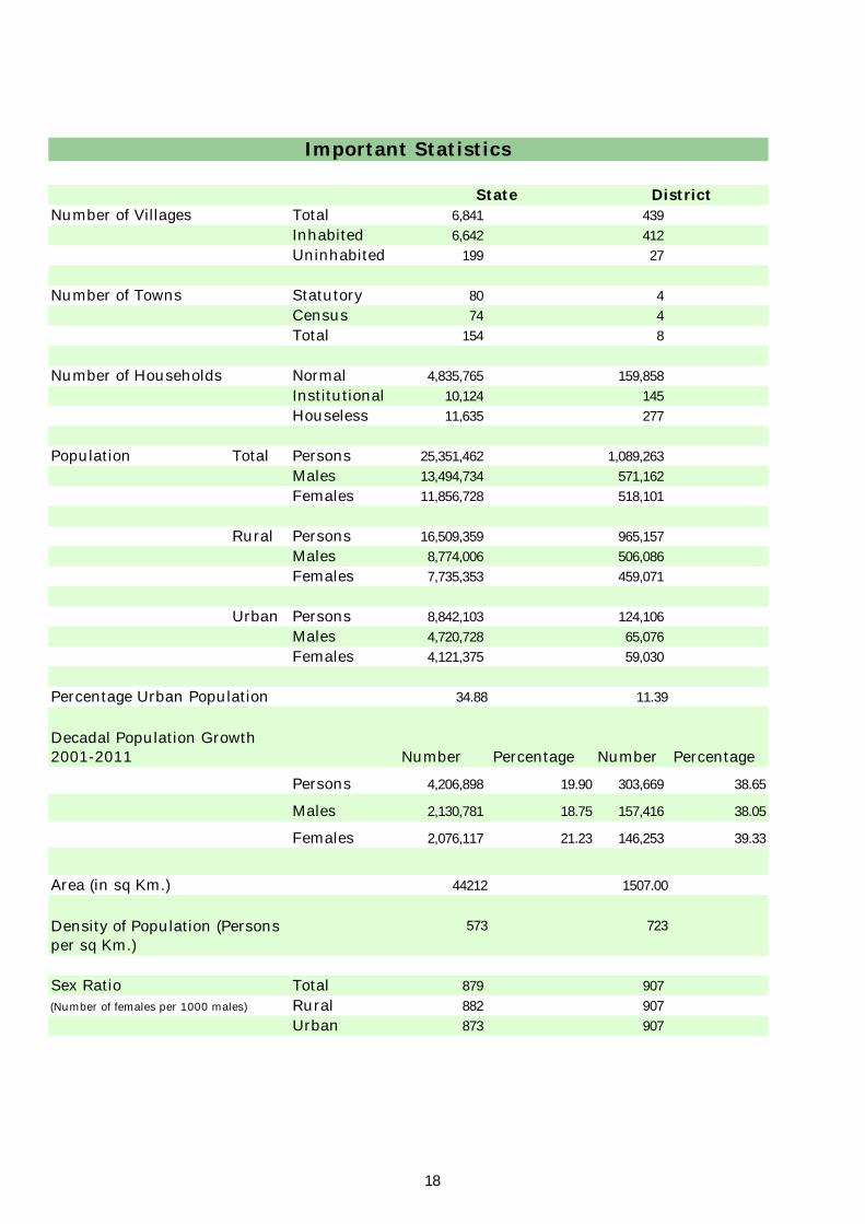
Number of Villages Total 6,841 439
Inhabited 6,642 412
Uninhabited 199 27
Number of Towns Statutory 80 4
Census 74 4
Total 154 8
Number of Households Normal 4,835,765 159,858
Institutional 10,124 145
Houseless 11,635 277
Population Total Persons 25,351,462 1,089,263
Males 13,494,734 571,162
Females 11,856,728 518,101
Rural Persons 16,509,359 965,157
Males 8,774,006 506,086
Females 7,735,353 459,071
Urban Persons 8,842,103 124,106
Males 4,720,728 65,076
Females 4,121,375 59,030
Percentage Urban Population 34.88 11.39
Number Percentage Number Percentage
Persons 4,206,898 19.90 303,669 38.65
Males 2,130,781 18.75 157,416 38.05
Females 2,076,117 21.23 146,253 39.33
Area (in sq Km.) 44212 1507.00
573 723
Sex Ratio Total 879 907
(Number of females per 1000 males) Rural 882 907
Urban 873 907
District
Important Statistics
Decadal Population Growth 2001-2011
Density of Population (Persons per sq Km.)
State
18
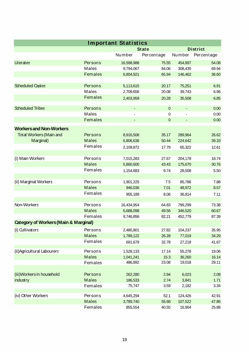
Important Statistics
Number Percentage Number Percentage
Literates Persons 16,598,988 75.55 454,897 54.08
Males 9,794,067 84.06 308,435 69.94
Females 6,804,921 65.94 146,462 36.60
Scheduled Castes Persons 5,113,615 20.17 75,251 6.91
Males 2,709,656 20.08 39,743 6.96
Females 2,403,959 20.28 35,508 6.85
Scheduled Tribes Persons - 0 - 0.00
Males - 0 - 0.00
Females - 0 - 0.00
Workers and Non-WorkersPersons 8,916,508 35.17 289,964 26.62
Males 6,806,636 50.44 224,642 39.33
Females 2,109,872 17.79 65,322 12.61
(i) Main Workers Persons 7,015,283 27.67 204,178 18.74
Males 5,860,600 43.43 175,670 30.76
Females 1,154,683 9.74 28,508 5.50
(ii) Marginal Workers Persons 1,901,225 7.5 85,786 7.88
Males 946,036 7.01 48,972 8.57
Females 955,189 8.06 36,814 7.11
Non-Workers Persons 16,434,954 64.83 799,299 73.38
Males 6,688,098 49.56 346,520 60.67
Females 9,746,856 82.21 452,779 87.39
(i) Cultivators Persons 2,480,801 27.82 104,237 35.95
Males 1,789,122 26.28 77,019 34.29
Females 691,679 32.78 27,218 41.67
(ii)Agricultural Labourers Persons 1,528,133 17.14 55,278 19.06
Males 1,041,241 15.3 36,260 16.14
Females 486,892 23.08 19,018 29.11
Persons 262,280 2.94 6,023 2.08
Males 186,533 2.74 3,841 1.71
Females 75,747 3.59 2,182 3.34
(iv) Other Workers Persons 4,645,294 52.1 124,426 42.91
Males 3,789,740 55.68 107,522 47.86
Females 855,554 40.55 16,904 25.88
Total Workers (Main and Marginal)
Category of Workers (Main & Marginal)
(iii)Workers in household industry
State District
19

Section - I
Primary Census Abstract (PCA)
22
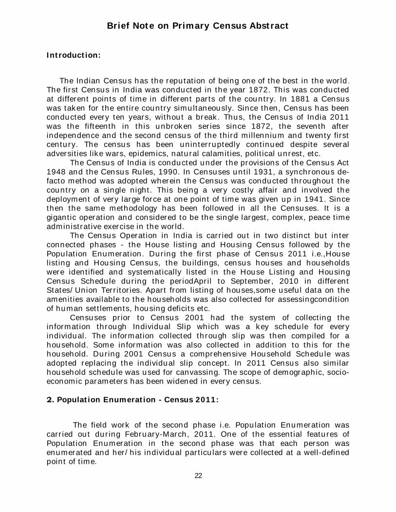
Brief Note on Primary Census Abstract
Introduction:
The Indian Census has the reputation of being one of the best in the world. The first Census in India was conducted in the year 1872. This was conducted at different points of time in different parts of the country. In 1881 a Census was taken for the entire country simultaneously. Since then, Census has been conducted every ten years, without a break. Thus, the Census of India 2011 was the fifteenth in this unbroken series since 1872, the seventh after independence and the second census of the third millennium and twenty first century. The census has been uninterruptedly continued despite several adversities like wars, epidemics, natural calamities, political unrest, etc.
The Census of India is conducted under the provisions of the Census Act 1948 and the Census Rules, 1990. In Censuses until 1931, a synchronous de-facto method was adopted wherein the Census was conducted throughout the country on a single night. This being a very costly affair and involved the deployment of very large force at one point of time was given up in 1941. Since then the same methodology has been followed in all the Censuses. It is a gigantic operation and considered to be the single largest, complex, peace time administrative exercise in the world.
The Census Operation in India is carried out in two distinct but inter connected phases - the House listing and Housing Census followed by the Population Enumeration. During the first phase of Census 2011 i.e.,House listing and Housing Census, the buildings, census houses and households were identified and systematically listed in the House Listing and Housing Census Schedule during the periodApril to September, 2010 in different States/Union Territories. Apart from listing of houses,some useful data on the amenities available to the households was also collected for assessingcondition of human settlements, housing deficits etc.
Censuses prior to Census 2001 had the system of collecting the information through Individual Slip which was a key schedule for every individual. The information collected through slip was then compiled for a household. Some information was also collected in addition to this for the household. During 2001 Census a comprehensive Household Schedule was adopted replacing the individual slip concept. In 2011 Census also similar household schedule was used for canvassing. The scope of demographic, socio-economic parameters has been widened in every census.
2. Population Enumeration - Census 2011:
The field work of the second phase i.e. Population Enumeration was carried out during February-March, 2011. One of the essential features of Population Enumeration in the second phase was that each person was enumerated and her/his individual particulars were collected at a well-defined point of time.
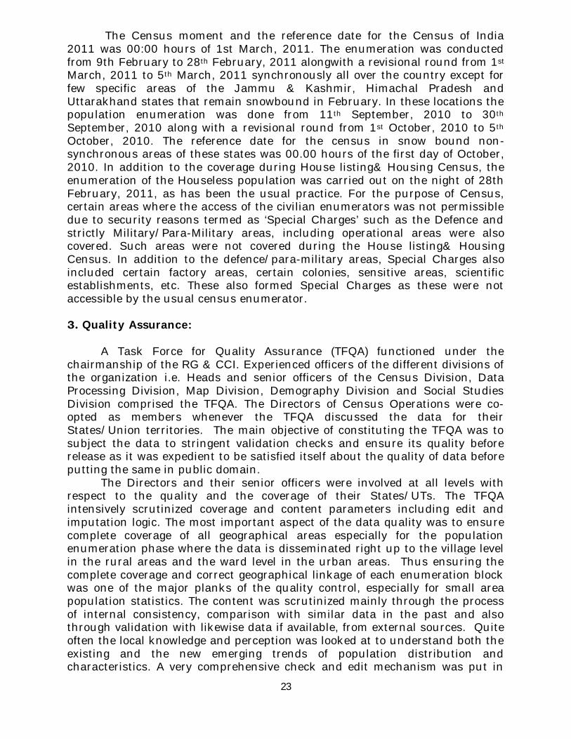
23
The Census moment and the reference date for the Census of India 2011 was 00:00 hours of 1st March, 2011. The enumeration was conducted from 9th February to 28th February, 2011 alongwith a revisional round from 1st March, 2011 to 5th March, 2011 synchronously all over the country except for few specific areas of the Jammu & Kashmir, Himachal Pradesh and Uttarakhand states that remain snowbound in February. In these locations the population enumeration was done from 11th September, 2010 to 30th September, 2010 along with a revisional round from 1st October, 2010 to 5th October, 2010. The reference date for the census in snow bound non-synchronous areas of these states was 00.00 hours of the first day of October, 2010. In addition to the coverage during House listing& Housing Census, the enumeration of the Houseless population was carried out on the night of 28th February, 2011, as has been the usual practice. For the purpose of Census, certain areas where the access of the civilian enumerators was not permissible due to security reasons termed as ‘Special Charges’ such as the Defence and strictly Military/Para-Military areas, including operational areas were also covered. Such areas were not covered during the House listing& Housing Census. In addition to the defence/para-military areas, Special Charges also included certain factory areas, certain colonies, sensitive areas, scientific establishments, etc. These also formed Special Charges as these were not accessible by the usual census enumerator.
3. Quality Assurance:
A Task Force for Quality Assurance (TFQA) functioned under the chairmanship of the RG & CCI. Experienced officers of the different divisions of the organization i.e. Heads and senior officers of the Census Division, Data Processing Division, Map Division, Demography Division and Social Studies Division comprised the TFQA. The Directors of Census Operations were co-opted as members whenever the TFQA discussed the data for their States/Union territories. The main objective of constituting the TFQA was to subject the data to stringent validation checks and ensure its quality before release as it was expedient to be satisfied itself about the quality of data before putting the same in public domain.
The Directors and their senior officers were involved at all levels with respect to the quality and the coverage of their States/UTs. The TFQA intensively scrutinized coverage and content parameters including edit and imputation logic. The most important aspect of the data quality was to ensure complete coverage of all geographical areas especially for the population enumeration phase where the data is disseminated right up to the village level in the rural areas and the ward level in the urban areas. Thus ensuring the complete coverage and correct geographical linkage of each enumeration block was one of the major planks of the quality control, especially for small area population statistics. The content was scrutinized mainly through the process of internal consistency, comparison with similar data in the past and also through validation with likewise data if available, from external sources. Quite often the local knowledge and perception was looked at to understand both the existing and the new emerging trends of population distribution and characteristics. A very comprehensive check and edit mechanism was put in
24
place to objectively examine the preliminary Census 2011 Population Enumeration results and finally clear them for use. The population data was cleared only after the full possible satisfaction of the TFQA.
The entire work relating to the data validation and scrutiny was completed by all the States/Union territories under the overall supervision and monitoring of the Census Division of the Office of the Registrar General, India with active cooperation and support of the Social Studies Division, Data Processing Division, Data Dissemination Division and Map Division.
4. Primary Census Abstract:
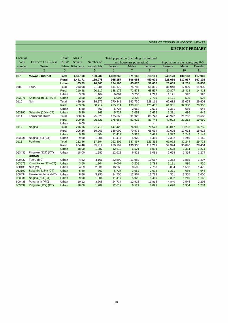
The Primary Census Abstract which is an important publication of 2011 Census gives basicinformation on Area, Total Number of Households, Total Population, Scheduled Castes, Scheduled TribesPopulation, Population in the age group 0-6, Literates, Main Workers and Marginal Workers classified by thefour broad industrial categories, namely, (i) Cultivators, (ii) Agricultural Labourers, (iii) Household Industry Workers, and (iv) Other Workers and also Non-Workers. The characteristics of the Total Population includeScheduled Castes, Scheduled Tribes, Institutional and Houseless Population and are presented by sex andrural-urban residence.
In 1981 census main workers were presented into four categories. As regards 1991 Census, the nine-fold industrialclassification of main workers has been given in the Primary Census Abstract. One of the important features of the Primary Census Abstract of 1991 Census was the presentation of population of the age group 0-6 which is continued in 2001 and 2011 Census.All the children of age 6 years or less have been treated as illiterate even if the child is going to a school and may have picked up reading and writing. This will help the data users in better analysis and understanding of the literacy data as the literacy rate is calculated with 7 years and above population and it is referred as effective literacy rate.In 2001 and 2011 census four categories of main workers have been given in the Primary Census Abstract.
5. Level of Presentation of PCA data in District CensusHandbooks:
The format of Primary Census Abstract (PCA) adopted in the DCHB of 2001 Census has been continued for 2011 Census as the data on four categories of works have been presented similar to 2001 census. The Primary Census Abstract data in different PCAs are presented at different levels. The level of presentation of Primary Census Abstracts in DCHB is as under:
1.District Primary Census Abstract -District/C.D. Block/Town.2. Primary Census Abstract for Scheduled Castes- District/C.D. Block/Town.3.Primary Census Abstract for Scheduled Tribes -District/C.D. Block/Town.4. Village Primary Census Abstract -C.D. Block/Village wise.5. Urban Primary Census Abstract- Town/Ward level.
25
The PCA Data for villages was presented C.D. Block wise for the first time in 1991 Census. Thispractice is continued in 2001 and 2011 Census. The term ‘Total Population’ includes the Scheduled Castes, the Scheduled Tribes, the Institutional and the Houseless populations. An appendix to District Primary Census Abstract has also been furnished showing urban enumeration block-wise particulars on Total Population, the Scheduled Castes Population and the Scheduled Tribes Population for each town.
6. Area Figures:
The area figures supplied by local revenue authorities of the district in respect of tahsils, Police Stations and by the local bodies in respect of towns are given in square kilometers. The area figures of the villages supplied by the Tahsildars in acres have been converted and shown in hectares. The area figures of the C.D. Block are the total of the village areas coming under each C.D. Block. The area figures for the district are the same as adopted by the Surveyor General of India to maintain uniformity at the national level.
-----------------------------------------------------------------

District Primary Census Abstract
DISTRICT CENSUS HANDBOOK : MEWAT
DISTRICT PRIMARY
Persons Males Females Persons Males Females1 2 3 4 5 6 7 8 9 10 11
087 Mewat - District Total 1,507.00 160,280 1,089,263 571,162 518,101 248,128 130,168 117,960 Rural 1,441.71 139,975 965,157 506,086 459,071 225,069 117,967 107,102 Urban 65.29 20,305 124,106 65,076 59,030 23,059 12,201 10,858
0109 Taoru Total 213.98 21,281 144,179 75,783 68,396 31,948 17,009 14,939 Rural 210.48 20,117 138,172 72,575 65,597 30,827 16,414 14,413 Urban 3.50 1,164 6,007 3,208 2,799 1,121 595 526
063071 Khori Kalan (37) (CT) Urban 3.50 1,164 6,007 3,208 2,799 1,121 595 526 0110 Nuh Total 459.16 39,577 270,841 142,730 128,111 62,682 33,074 29,608
Rural 453.36 38,714 265,114 139,678 125,436 61,351 32,388 28,963 Urban 5.80 863 5,727 3,052 2,675 1,331 686 645
063190 Salamba (154) (CT) Urban 5.80 863 5,727 3,052 2,675 1,331 686 645 0111 Ferozepur Jhirka Total 300.66 25,323 175,665 91,922 83,743 40,922 21,262 19,660
Rural 300.66 25,323 175,665 91,922 83,743 40,922 21,262 19,660 Urban 0.00 - - - - - - -
0112 Nagina Total 216.16 21,713 147,426 76,903 70,523 35,017 18,262 16,755 Rural 206.26 19,909 136,009 70,975 65,034 32,625 17,013 15,612 Urban 9.90 1,804 11,417 5,928 5,489 2,392 1,249 1,143
063336 Nagina (51) (CT) Urban 9.90 1,804 11,417 5,928 5,489 2,392 1,249 1,143 0113 Punhana Total 282.46 37,894 262,809 137,457 125,352 61,972 32,244 29,728
Rural 264.46 35,912 250,197 130,936 119,261 59,344 30,890 28,454 Urban 18.00 1,982 12,612 6,521 6,091 2,628 1,354 1,274
063432 Pingwan (127) (CT) Urban 18.00 1,982 12,612 6,521 6,091 2,628 1,354 1,274 URBAN
800432 Taoru (MC) Urban 4.52 4,161 22,599 11,982 10,617 3,352 1,855 1,497 063071 Khori Kalan (37) (CT) Urban 3.50 1,164 6,007 3,208 2,799 1,121 595 526 800433 Nuh (MC) Urban 4.59 2,636 16,260 8,502 7,758 3,034 1,562 1,472 063190 Salamba (154) (CT) Urban 5.80 863 5,727 3,052 2,675 1,331 686 645 800434 Ferozepur jhirka (MC) Urban 8.86 3,990 24,750 12,967 11,783 4,361 2,355 2,006 063336 Nagina (51) (CT) Urban 9.90 1,804 11,417 5,928 5,489 2,392 1,249 1,143 800435 Punahana (MC) Urban 10.12 3,705 24,734 12,916 11,818 4,840 2,545 2,295 063432 Pingwan (127) (CT) Urban 18.00 1,982 12,612 6,521 6,091 2,628 1,354 1,274
Location code
numberDistrict/ CD Block/
Town
Total/ Rural/ Urban
Area in Square
KilometreNumber of households
Total population (including institutional and houseless population) Population in the age-group 0-6
28
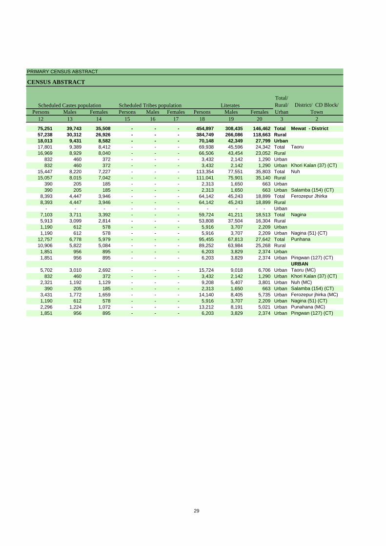
PRIMARY CENSUS ABSTRACT
CENSUS ABSTRACT
Persons Males Females Persons Males Females Persons Males Females12 13 14 15 16 17 18 19 20 3 2
75,251 39,743 35,508 - - - 454,897 308,435 146,462 Total Mewat - District57,238 30,312 26,926 - - - 384,749 266,086 118,663 Rural18,013 9,431 8,582 - - - 70,148 42,349 27,799 Urban17,801 9,389 8,412 - - - 69,938 45,596 24,342 Total Taoru16,969 8,929 8,040 - - - 66,506 43,454 23,052 Rural
832 460 372 - - - 3,432 2,142 1,290 Urban832 460 372 - - - 3,432 2,142 1,290 Urban Khori Kalan (37) (CT)
15,447 8,220 7,227 - - - 113,354 77,551 35,803 Total Nuh15,057 8,015 7,042 - - - 111,041 75,901 35,140 Rural
390 205 185 - - - 2,313 1,650 663 Urban390 205 185 - - - 2,313 1,650 663 Urban Salamba (154) (CT)
8,393 4,447 3,946 - - - 64,142 45,243 18,899 Total Ferozepur Jhirka8,393 4,447 3,946 - - - 64,142 45,243 18,899 Rural
- - - - - - - - - Urban7,103 3,711 3,392 - - - 59,724 41,211 18,513 Total Nagina5,913 3,099 2,814 - - - 53,808 37,504 16,304 Rural1,190 612 578 - - - 5,916 3,707 2,209 Urban1,190 612 578 - - - 5,916 3,707 2,209 Urban Nagina (51) (CT)
12,757 6,778 5,979 - - - 95,455 67,813 27,642 Total Punhana10,906 5,822 5,084 - - - 89,252 63,984 25,268 Rural1,851 956 895 - - - 6,203 3,829 2,374 Urban1,851 956 895 - - - 6,203 3,829 2,374 Urban Pingwan (127) (CT)
URBAN5,702 3,010 2,692 - - - 15,724 9,018 6,706 Urban Taoru (MC)
832 460 372 - - - 3,432 2,142 1,290 Urban Khori Kalan (37) (CT)2,321 1,192 1,129 - - - 9,208 5,407 3,801 Urban Nuh (MC)
390 205 185 - - - 2,313 1,650 663 Urban Salamba (154) (CT)3,431 1,772 1,659 - - - 14,140 8,405 5,735 Urban Ferozepur jhirka (MC)1,190 612 578 - - - 5,916 3,707 2,209 Urban Nagina (51) (CT)2,296 1,224 1,072 - - - 13,212 8,191 5,021 Urban Punahana (MC)1,851 956 895 - - - 6,203 3,829 2,374 Urban Pingwan (127) (CT)
Scheduled Castes population Scheduled Tribes population LiteratesTotal/ Rural/ Urban
District/ CD Block/ Town
29
DISTRICT CENSUS HANDBOOK : MEWAT
DISTRICT PRIMARY
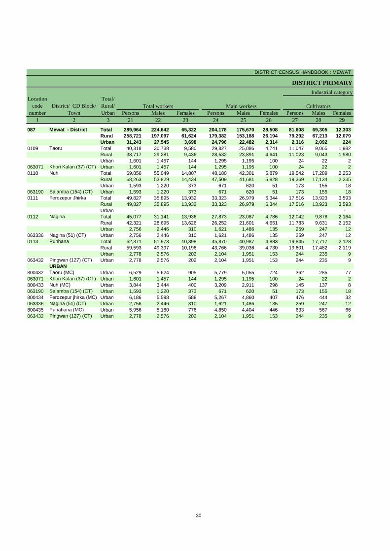
Persons Males Females Persons Males Females Persons Males Females1 2 3 21 22 23 24 25 26 27 28 29
087 Mewat - District Total 289,964 224,642 65,322 204,178 175,670 28,508 81,608 69,305 12,303 Rural 258,721 197,097 61,624 179,382 153,188 26,194 79,292 67,213 12,079 Urban 31,243 27,545 3,698 24,796 22,482 2,314 2,316 2,092 224
0109 Taoru Total 40,318 30,738 9,580 29,827 25,086 4,741 11,047 9,065 1,982 Rural 38,717 29,281 9,436 28,532 23,891 4,641 11,023 9,043 1,980 Urban 1,601 1,457 144 1,295 1,195 100 24 22 2
063071 Khori Kalan (37) (CT) Urban 1,601 1,457 144 1,295 1,195 100 24 22 2 0110 Nuh Total 69,856 55,049 14,807 48,180 42,301 5,879 19,542 17,289 2,253
Rural 68,263 53,829 14,434 47,509 41,681 5,828 19,369 17,134 2,235 Urban 1,593 1,220 373 671 620 51 173 155 18
063190 Salamba (154) (CT) Urban 1,593 1,220 373 671 620 51 173 155 18 0111 Ferozepur Jhirka Total 49,827 35,895 13,932 33,323 26,979 6,344 17,516 13,923 3,593
Rural 49,827 35,895 13,932 33,323 26,979 6,344 17,516 13,923 3,593 Urban - - - - - - - - -
0112 Nagina Total 45,077 31,141 13,936 27,873 23,087 4,786 12,042 9,878 2,164 Rural 42,321 28,695 13,626 26,252 21,601 4,651 11,783 9,631 2,152 Urban 2,756 2,446 310 1,621 1,486 135 259 247 12
063336 Nagina (51) (CT) Urban 2,756 2,446 310 1,621 1,486 135 259 247 12 0113 Punhana Total 62,371 51,973 10,398 45,870 40,987 4,883 19,845 17,717 2,128
Rural 59,593 49,397 10,196 43,766 39,036 4,730 19,601 17,482 2,119 Urban 2,778 2,576 202 2,104 1,951 153 244 235 9
063432 Pingwan (127) (CT) Urban 2,778 2,576 202 2,104 1,951 153 244 235 9 URBAN
800432 Taoru (MC) Urban 6,529 5,624 905 5,779 5,055 724 362 285 77 063071 Khori Kalan (37) (CT) Urban 1,601 1,457 144 1,295 1,195 100 24 22 2 800433 Nuh (MC) Urban 3,844 3,444 400 3,209 2,911 298 145 137 8 063190 Salamba (154) (CT) Urban 1,593 1,220 373 671 620 51 173 155 18 800434 Ferozepur jhirka (MC) Urban 6,186 5,598 588 5,267 4,860 407 476 444 32 063336 Nagina (51) (CT) Urban 2,756 2,446 310 1,621 1,486 135 259 247 12 800435 Punahana (MC) Urban 5,956 5,180 776 4,850 4,404 446 633 567 66 063432 Pingwan (127) (CT) Urban 2,778 2,576 202 2,104 1,951 153 244 235 9
Location code
numberDistrict/ CD Block/
Town
Total/ Rural/ Urban
Total workers Main workers
Industrial category
Cultivators
30
PRIMARY CENSUS ABSTRACT
CENSUS ABSTRACT
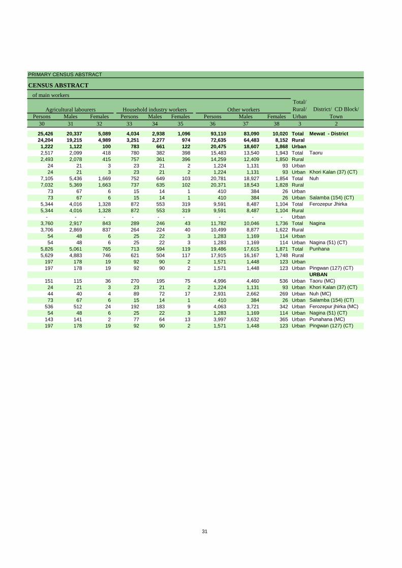
Persons Males Females Persons Males Females Persons Males Females30 31 32 33 34 35 36 37 38 3 2
25,426 20,337 5,089 4,034 2,938 1,096 93,110 83,090 10,020 Total Mewat - District24,204 19,215 4,989 3,251 2,277 974 72,635 64,483 8,152 Rural1,222 1,122 100 783 661 122 20,475 18,607 1,868 Urban2,517 2,099 418 780 382 398 15,483 13,540 1,943 Total Taoru2,493 2,078 415 757 361 396 14,259 12,409 1,850 Rural
24 21 3 23 21 2 1,224 1,131 93 Urban24 21 3 23 21 2 1,224 1,131 93 Urban Khori Kalan (37) (CT)
7,105 5,436 1,669 752 649 103 20,781 18,927 1,854 Total Nuh7,032 5,369 1,663 737 635 102 20,371 18,543 1,828 Rural
73 67 6 15 14 1 410 384 26 Urban73 67 6 15 14 1 410 384 26 Urban Salamba (154) (CT)
5,344 4,016 1,328 872 553 319 9,591 8,487 1,104 Total Ferozepur Jhirka5,344 4,016 1,328 872 553 319 9,591 8,487 1,104 Rural
- - - - - - - - - Urban3,760 2,917 843 289 246 43 11,782 10,046 1,736 Total Nagina3,706 2,869 837 264 224 40 10,499 8,877 1,622 Rural
54 48 6 25 22 3 1,283 1,169 114 Urban54 48 6 25 22 3 1,283 1,169 114 Urban Nagina (51) (CT)
5,826 5,061 765 713 594 119 19,486 17,615 1,871 Total Punhana5,629 4,883 746 621 504 117 17,915 16,167 1,748 Rural
197 178 19 92 90 2 1,571 1,448 123 Urban197 178 19 92 90 2 1,571 1,448 123 Urban Pingwan (127) (CT)
URBAN151 115 36 270 195 75 4,996 4,460 536 Urban Taoru (MC)24 21 3 23 21 2 1,224 1,131 93 Urban Khori Kalan (37) (CT)44 40 4 89 72 17 2,931 2,662 269 Urban Nuh (MC)73 67 6 15 14 1 410 384 26 Urban Salamba (154) (CT)
536 512 24 192 183 9 4,063 3,721 342 Urban Ferozepur jhirka (MC)54 48 6 25 22 3 1,283 1,169 114 Urban Nagina (51) (CT)
143 141 2 77 64 13 3,997 3,632 365 Urban Punahana (MC)197 178 19 92 90 2 1,571 1,448 123 Urban Pingwan (127) (CT)
of main workers
Agricultural labourers Household industry workers Other workersTotal/ Rural/ Urban
District/ CD Block/ Town
31
DISTRICT CENSUS HANDBOOK : MEWAT
DISTRICT PRIMARY
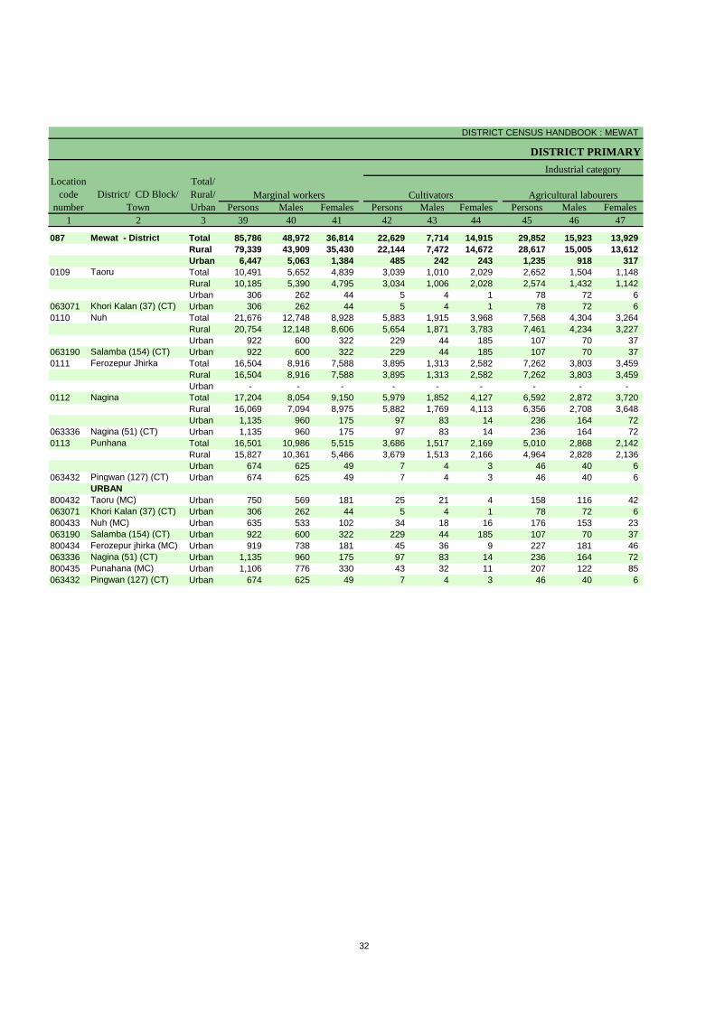
Persons Males Females Persons Males Females Persons Males Females1 2 3 39 40 41 42 43 44 45 46 47
087 Mewat - District Total 85,786 48,972 36,814 22,629 7,714 14,915 29,852 15,923 13,929 Rural 79,339 43,909 35,430 22,144 7,472 14,672 28,617 15,005 13,612 Urban 6,447 5,063 1,384 485 242 243 1,235 918 317
0109 Taoru Total 10,491 5,652 4,839 3,039 1,010 2,029 2,652 1,504 1,148 Rural 10,185 5,390 4,795 3,034 1,006 2,028 2,574 1,432 1,142 Urban 306 262 44 5 4 1 78 72 6
063071 Khori Kalan (37) (CT) Urban 306 262 44 5 4 1 78 72 6 0110 Nuh Total 21,676 12,748 8,928 5,883 1,915 3,968 7,568 4,304 3,264
Rural 20,754 12,148 8,606 5,654 1,871 3,783 7,461 4,234 3,227 Urban 922 600 322 229 44 185 107 70 37
063190 Salamba (154) (CT) Urban 922 600 322 229 44 185 107 70 37 0111 Ferozepur Jhirka Total 16,504 8,916 7,588 3,895 1,313 2,582 7,262 3,803 3,459
Rural 16,504 8,916 7,588 3,895 1,313 2,582 7,262 3,803 3,459 Urban - - - - - - - - -
0112 Nagina Total 17,204 8,054 9,150 5,979 1,852 4,127 6,592 2,872 3,720 Rural 16,069 7,094 8,975 5,882 1,769 4,113 6,356 2,708 3,648 Urban 1,135 960 175 97 83 14 236 164 72
063336 Nagina (51) (CT) Urban 1,135 960 175 97 83 14 236 164 72 0113 Punhana Total 16,501 10,986 5,515 3,686 1,517 2,169 5,010 2,868 2,142
Rural 15,827 10,361 5,466 3,679 1,513 2,166 4,964 2,828 2,136 Urban 674 625 49 7 4 3 46 40 6
063432 Pingwan (127) (CT) Urban 674 625 49 7 4 3 46 40 6 URBAN
800432 Taoru (MC) Urban 750 569 181 25 21 4 158 116 42 063071 Khori Kalan (37) (CT) Urban 306 262 44 5 4 1 78 72 6 800433 Nuh (MC) Urban 635 533 102 34 18 16 176 153 23 063190 Salamba (154) (CT) Urban 922 600 322 229 44 185 107 70 37 800434 Ferozepur jhirka (MC) Urban 919 738 181 45 36 9 227 181 46 063336 Nagina (51) (CT) Urban 1,135 960 175 97 83 14 236 164 72 800435 Punahana (MC) Urban 1,106 776 330 43 32 11 207 122 85 063432 Pingwan (127) (CT) Urban 674 625 49 7 4 3 46 40 6
Marginal workers CultivatorsLocation
code number
District/ CD Block/ Town
Total/ Rural/ Urban
Industrial category
Agricultural labourers
32
PRIMARY CENSUS ABSTRACT
CENSUS ABSTRACT
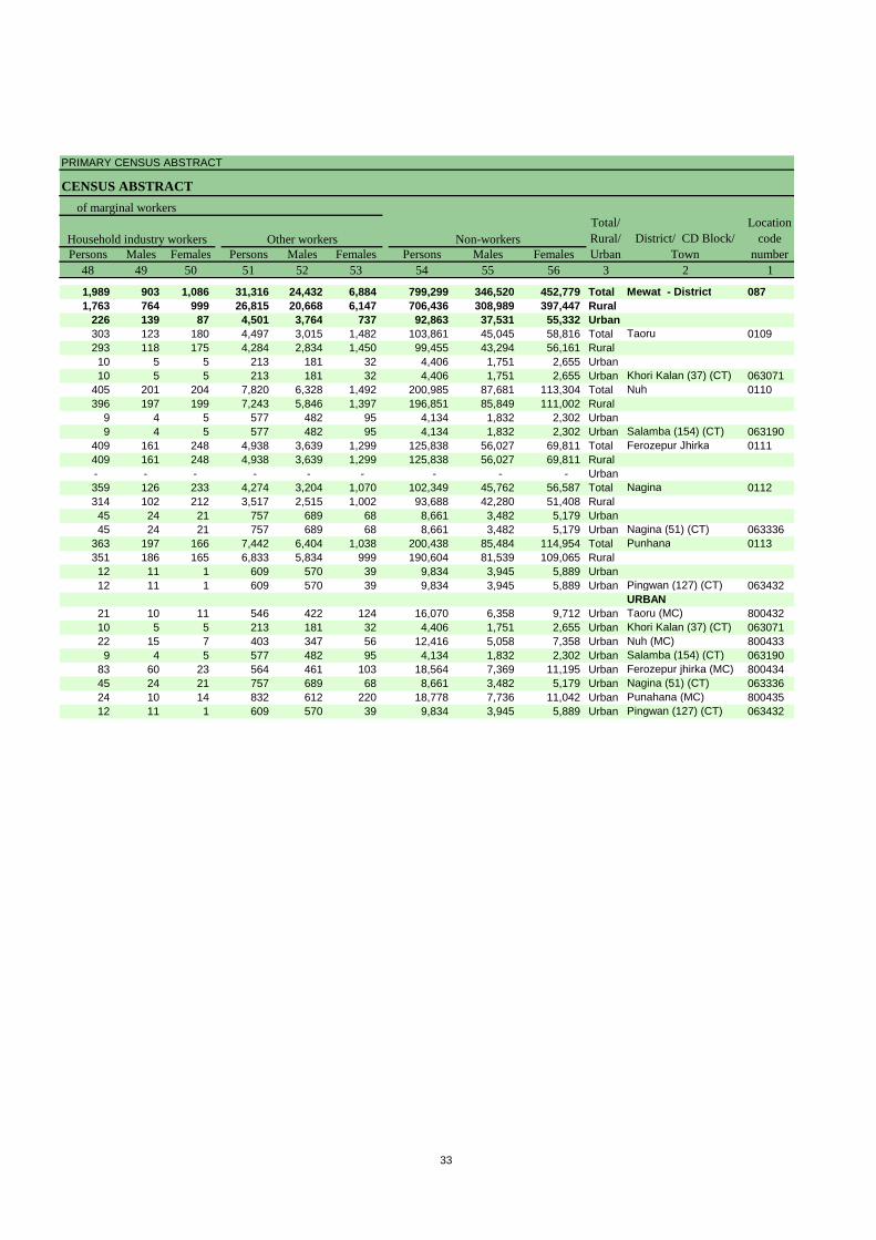
Persons Males Females Persons Males Females Persons Males Females48 49 50 51 52 53 54 55 56 3 2 1
1,989 903 1,086 31,316 24,432 6,884 799,299 346,520 452,779 Total Mewat - District 0871,763 764 999 26,815 20,668 6,147 706,436 308,989 397,447 Rural
226 139 87 4,501 3,764 737 92,863 37,531 55,332 Urban303 123 180 4,497 3,015 1,482 103,861 45,045 58,816 Total Taoru 0109293 118 175 4,284 2,834 1,450 99,455 43,294 56,161 Rural10 5 5 213 181 32 4,406 1,751 2,655 Urban10 5 5 213 181 32 4,406 1,751 2,655 Urban Khori Kalan (37) (CT) 063071
405 201 204 7,820 6,328 1,492 200,985 87,681 113,304 Total Nuh 0110396 197 199 7,243 5,846 1,397 196,851 85,849 111,002 Rural
9 4 5 577 482 95 4,134 1,832 2,302 Urban9 4 5 577 482 95 4,134 1,832 2,302 Urban Salamba (154) (CT) 063190
409 161 248 4,938 3,639 1,299 125,838 56,027 69,811 Total Ferozepur Jhirka 0111409 161 248 4,938 3,639 1,299 125,838 56,027 69,811 Rural- - - - - - - - - Urban359 126 233 4,274 3,204 1,070 102,349 45,762 56,587 Total Nagina 0112314 102 212 3,517 2,515 1,002 93,688 42,280 51,408 Rural45 24 21 757 689 68 8,661 3,482 5,179 Urban45 24 21 757 689 68 8,661 3,482 5,179 Urban Nagina (51) (CT) 063336
363 197 166 7,442 6,404 1,038 200,438 85,484 114,954 Total Punhana 0113351 186 165 6,833 5,834 999 190,604 81,539 109,065 Rural12 11 1 609 570 39 9,834 3,945 5,889 Urban12 11 1 609 570 39 9,834 3,945 5,889 Urban Pingwan (127) (CT) 063432
URBAN21 10 11 546 422 124 16,070 6,358 9,712 Urban Taoru (MC) 80043210 5 5 213 181 32 4,406 1,751 2,655 Urban Khori Kalan (37) (CT) 06307122 15 7 403 347 56 12,416 5,058 7,358 Urban Nuh (MC) 8004339 4 5 577 482 95 4,134 1,832 2,302 Urban Salamba (154) (CT) 063190
83 60 23 564 461 103 18,564 7,369 11,195 Urban Ferozepur jhirka (MC) 80043445 24 21 757 689 68 8,661 3,482 5,179 Urban Nagina (51) (CT) 06333624 10 14 832 612 220 18,778 7,736 11,042 Urban Punahana (MC) 80043512 11 1 609 570 39 9,834 3,945 5,889 Urban Pingwan (127) (CT) 063432
Location code
numberHousehold industry workers Other workers Non-workers
of marginal workersTotal/ Rural/ Urban
District/ CD Block/ Town
33


Appendix to District Primary Census Abstract Total, Scheduled Castes and
Scheduled Tribes Population - Urban Block wise
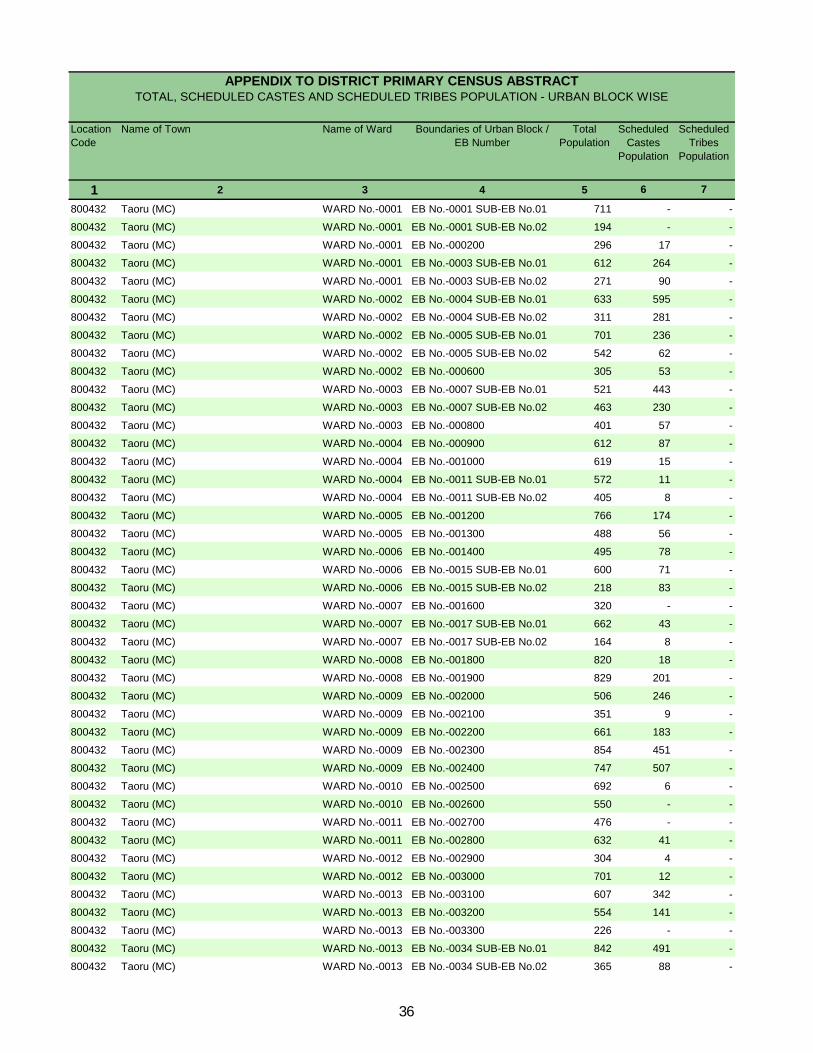
Location Code
Name of Town Name of Ward Boundaries of Urban Block / EB Number
Total Population
Scheduled Castes
Population
Scheduled Tribes
Population
1 2 3 4 5 6 7
800432 Taoru (MC) WARD No.-0001 EB No.-0001 SUB-EB No.01 711 - -
800432 Taoru (MC) WARD No.-0001 EB No.-0001 SUB-EB No.02 194 - -
800432 Taoru (MC) WARD No.-0001 EB No.-000200 296 17 -
800432 Taoru (MC) WARD No.-0001 EB No.-0003 SUB-EB No.01 612 264 -
800432 Taoru (MC) WARD No.-0001 EB No.-0003 SUB-EB No.02 271 90 -
800432 Taoru (MC) WARD No.-0002 EB No.-0004 SUB-EB No.01 633 595 -
800432 Taoru (MC) WARD No.-0002 EB No.-0004 SUB-EB No.02 311 281 -
800432 Taoru (MC) WARD No.-0002 EB No.-0005 SUB-EB No.01 701 236 -
800432 Taoru (MC) WARD No.-0002 EB No.-0005 SUB-EB No.02 542 62 -
800432 Taoru (MC) WARD No.-0002 EB No.-000600 305 53 -
800432 Taoru (MC) WARD No.-0003 EB No.-0007 SUB-EB No.01 521 443 -
800432 Taoru (MC) WARD No.-0003 EB No.-0007 SUB-EB No.02 463 230 -
800432 Taoru (MC) WARD No.-0003 EB No.-000800 401 57 -
800432 Taoru (MC) WARD No.-0004 EB No.-000900 612 87 -
800432 Taoru (MC) WARD No.-0004 EB No.-001000 619 15 -
800432 Taoru (MC) WARD No.-0004 EB No.-0011 SUB-EB No.01 572 11 -
800432 Taoru (MC) WARD No.-0004 EB No.-0011 SUB-EB No.02 405 8 -
800432 Taoru (MC) WARD No.-0005 EB No.-001200 766 174 -
800432 Taoru (MC) WARD No.-0005 EB No.-001300 488 56 -
800432 Taoru (MC) WARD No.-0006 EB No.-001400 495 78 -
800432 Taoru (MC) WARD No.-0006 EB No.-0015 SUB-EB No.01 600 71 -
800432 Taoru (MC) WARD No.-0006 EB No.-0015 SUB-EB No.02 218 83 -
800432 Taoru (MC) WARD No.-0007 EB No.-001600 320 - -
800432 Taoru (MC) WARD No.-0007 EB No.-0017 SUB-EB No.01 662 43 -
800432 Taoru (MC) WARD No.-0007 EB No.-0017 SUB-EB No.02 164 8 -
800432 Taoru (MC) WARD No.-0008 EB No.-001800 820 18 -
800432 Taoru (MC) WARD No.-0008 EB No.-001900 829 201 -
800432 Taoru (MC) WARD No.-0009 EB No.-002000 506 246 -
800432 Taoru (MC) WARD No.-0009 EB No.-002100 351 9 -
800432 Taoru (MC) WARD No.-0009 EB No.-002200 661 183 -
800432 Taoru (MC) WARD No.-0009 EB No.-002300 854 451 -
800432 Taoru (MC) WARD No.-0009 EB No.-002400 747 507 -
800432 Taoru (MC) WARD No.-0010 EB No.-002500 692 6 -
800432 Taoru (MC) WARD No.-0010 EB No.-002600 550 - -
800432 Taoru (MC) WARD No.-0011 EB No.-002700 476 - -
800432 Taoru (MC) WARD No.-0011 EB No.-002800 632 41 -
800432 Taoru (MC) WARD No.-0012 EB No.-002900 304 4 -
800432 Taoru (MC) WARD No.-0012 EB No.-003000 701 12 -
800432 Taoru (MC) WARD No.-0013 EB No.-003100 607 342 -
800432 Taoru (MC) WARD No.-0013 EB No.-003200 554 141 -
800432 Taoru (MC) WARD No.-0013 EB No.-003300 226 - -
800432 Taoru (MC) WARD No.-0013 EB No.-0034 SUB-EB No.01 842 491 -
800432 Taoru (MC) WARD No.-0013 EB No.-0034 SUB-EB No.02 365 88 -
APPENDIX TO DISTRICT PRIMARY CENSUS ABSTRACT TOTAL, SCHEDULED CASTES AND SCHEDULED TRIBES POPULATION - URBAN BLOCK WISE
36
Location Code
Name of Town Name of Ward Boundaries of Urban Block / EB Number
Total Population
Scheduled Castes
Population
Scheduled Tribes
Population
1 2 3 4 5 6 7
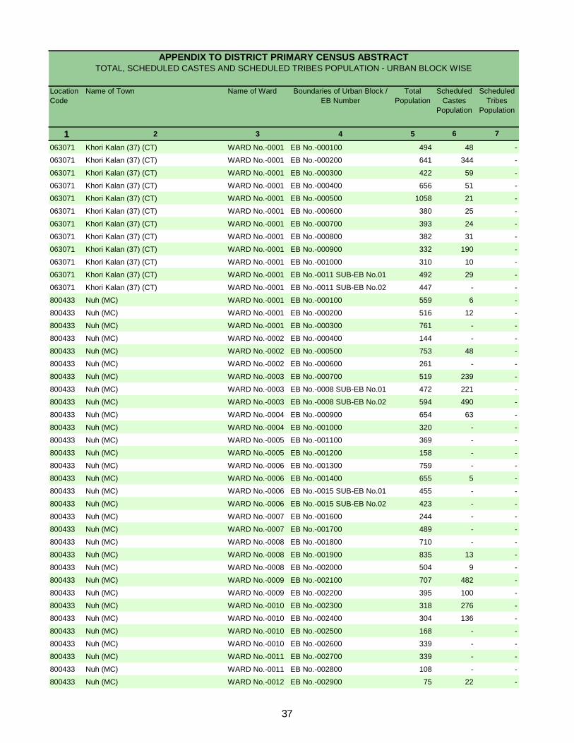
APPENDIX TO DISTRICT PRIMARY CENSUS ABSTRACT TOTAL, SCHEDULED CASTES AND SCHEDULED TRIBES POPULATION - URBAN BLOCK WISE
063071 Khori Kalan (37) (CT) WARD No.-0001 EB No.-000100 494 48 -
063071 Khori Kalan (37) (CT) WARD No.-0001 EB No.-000200 641 344 -
063071 Khori Kalan (37) (CT) WARD No.-0001 EB No.-000300 422 59 -
063071 Khori Kalan (37) (CT) WARD No.-0001 EB No.-000400 656 51 -
063071 Khori Kalan (37) (CT) WARD No.-0001 EB No.-000500 1058 21 -
063071 Khori Kalan (37) (CT) WARD No.-0001 EB No.-000600 380 25 -
063071 Khori Kalan (37) (CT) WARD No.-0001 EB No.-000700 393 24 -
063071 Khori Kalan (37) (CT) WARD No.-0001 EB No.-000800 382 31 -
063071 Khori Kalan (37) (CT) WARD No.-0001 EB No.-000900 332 190 -
063071 Khori Kalan (37) (CT) WARD No.-0001 EB No.-001000 310 10 -
063071 Khori Kalan (37) (CT) WARD No.-0001 EB No.-0011 SUB-EB No.01 492 29 -
063071 Khori Kalan (37) (CT) WARD No.-0001 EB No.-0011 SUB-EB No.02 447 - -
800433 Nuh (MC) WARD No.-0001 EB No.-000100 559 6 -
800433 Nuh (MC) WARD No.-0001 EB No.-000200 516 12 -
800433 Nuh (MC) WARD No.-0001 EB No.-000300 761 - -
800433 Nuh (MC) WARD No.-0002 EB No.-000400 144 - -
800433 Nuh (MC) WARD No.-0002 EB No.-000500 753 48 -
800433 Nuh (MC) WARD No.-0002 EB No.-000600 261 - -
800433 Nuh (MC) WARD No.-0003 EB No.-000700 519 239 -
800433 Nuh (MC) WARD No.-0003 EB No.-0008 SUB-EB No.01 472 221 -
800433 Nuh (MC) WARD No.-0003 EB No.-0008 SUB-EB No.02 594 490 -
800433 Nuh (MC) WARD No.-0004 EB No.-000900 654 63 -
800433 Nuh (MC) WARD No.-0004 EB No.-001000 320 - -
800433 Nuh (MC) WARD No.-0005 EB No.-001100 369 - -
800433 Nuh (MC) WARD No.-0005 EB No.-001200 158 - -
800433 Nuh (MC) WARD No.-0006 EB No.-001300 759 - -
800433 Nuh (MC) WARD No.-0006 EB No.-001400 655 5 -
800433 Nuh (MC) WARD No.-0006 EB No.-0015 SUB-EB No.01 455 - -
800433 Nuh (MC) WARD No.-0006 EB No.-0015 SUB-EB No.02 423 - -
800433 Nuh (MC) WARD No.-0007 EB No.-001600 244 - -
800433 Nuh (MC) WARD No.-0007 EB No.-001700 489 - -
800433 Nuh (MC) WARD No.-0008 EB No.-001800 710 - -
800433 Nuh (MC) WARD No.-0008 EB No.-001900 835 13 -
800433 Nuh (MC) WARD No.-0008 EB No.-002000 504 9 -
800433 Nuh (MC) WARD No.-0009 EB No.-002100 707 482 -
800433 Nuh (MC) WARD No.-0009 EB No.-002200 395 100 -
800433 Nuh (MC) WARD No.-0010 EB No.-002300 318 276 -
800433 Nuh (MC) WARD No.-0010 EB No.-002400 304 136 -
800433 Nuh (MC) WARD No.-0010 EB No.-002500 168 - -
800433 Nuh (MC) WARD No.-0010 EB No.-002600 339 - -
800433 Nuh (MC) WARD No.-0011 EB No.-002700 339 - -
800433 Nuh (MC) WARD No.-0011 EB No.-002800 108 - -
800433 Nuh (MC) WARD No.-0012 EB No.-002900 75 22 -
37
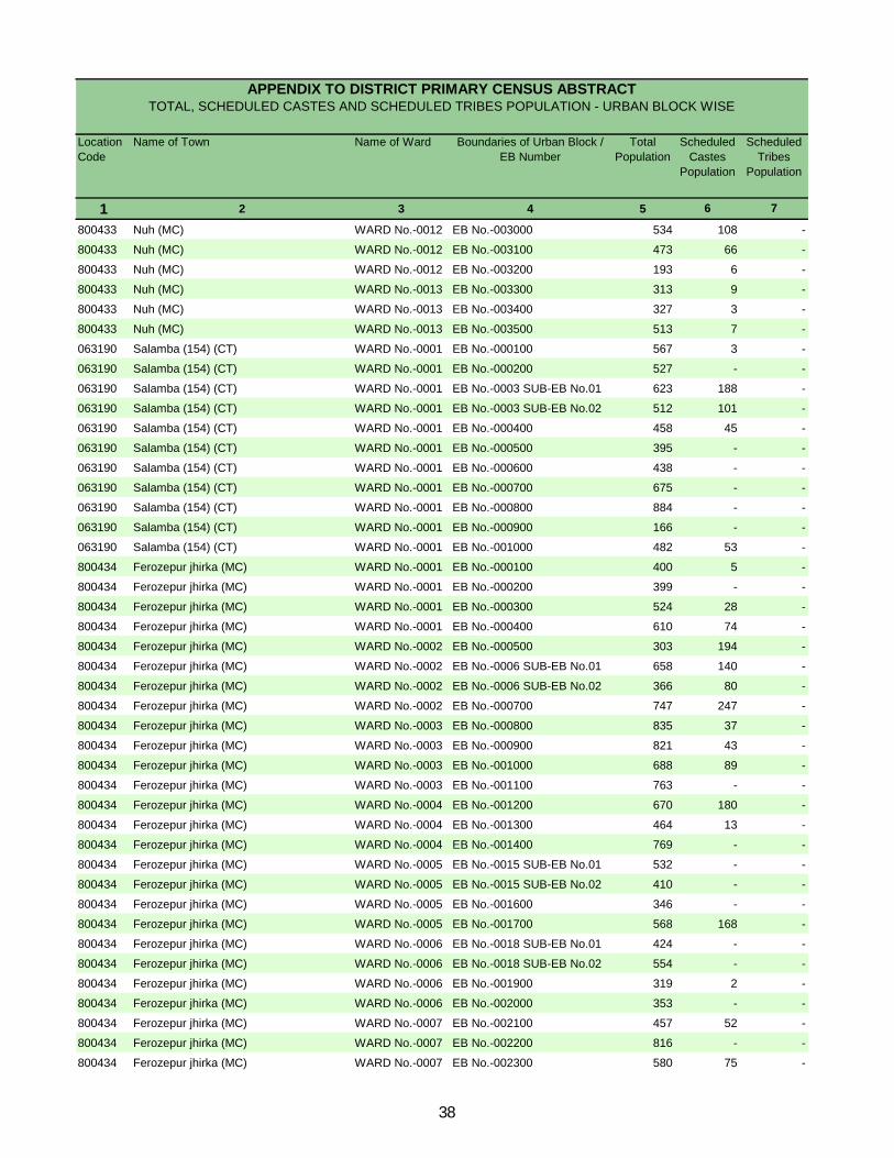
Location Code
Name of Town Name of Ward Boundaries of Urban Block / EB Number
Total Population
Scheduled Castes
Population
Scheduled Tribes
Population
1 2 3 4 5 6 7
APPENDIX TO DISTRICT PRIMARY CENSUS ABSTRACT TOTAL, SCHEDULED CASTES AND SCHEDULED TRIBES POPULATION - URBAN BLOCK WISE
800433 Nuh (MC) WARD No.-0012 EB No.-003000 534 108 -
800433 Nuh (MC) WARD No.-0012 EB No.-003100 473 66 -
800433 Nuh (MC) WARD No.-0012 EB No.-003200 193 6 -
800433 Nuh (MC) WARD No.-0013 EB No.-003300 313 9 -
800433 Nuh (MC) WARD No.-0013 EB No.-003400 327 3 -
800433 Nuh (MC) WARD No.-0013 EB No.-003500 513 7 -
063190 Salamba (154) (CT) WARD No.-0001 EB No.-000100 567 3 -
063190 Salamba (154) (CT) WARD No.-0001 EB No.-000200 527 - -
063190 Salamba (154) (CT) WARD No.-0001 EB No.-0003 SUB-EB No.01 623 188 -
063190 Salamba (154) (CT) WARD No.-0001 EB No.-0003 SUB-EB No.02 512 101 -
063190 Salamba (154) (CT) WARD No.-0001 EB No.-000400 458 45 -
063190 Salamba (154) (CT) WARD No.-0001 EB No.-000500 395 - -
063190 Salamba (154) (CT) WARD No.-0001 EB No.-000600 438 - -
063190 Salamba (154) (CT) WARD No.-0001 EB No.-000700 675 - -
063190 Salamba (154) (CT) WARD No.-0001 EB No.-000800 884 - -
063190 Salamba (154) (CT) WARD No.-0001 EB No.-000900 166 - -
063190 Salamba (154) (CT) WARD No.-0001 EB No.-001000 482 53 -
800434 Ferozepur jhirka (MC) WARD No.-0001 EB No.-000100 400 5 -
800434 Ferozepur jhirka (MC) WARD No.-0001 EB No.-000200 399 - -
800434 Ferozepur jhirka (MC) WARD No.-0001 EB No.-000300 524 28 -
800434 Ferozepur jhirka (MC) WARD No.-0001 EB No.-000400 610 74 -
800434 Ferozepur jhirka (MC) WARD No.-0002 EB No.-000500 303 194 -
800434 Ferozepur jhirka (MC) WARD No.-0002 EB No.-0006 SUB-EB No.01 658 140 -
800434 Ferozepur jhirka (MC) WARD No.-0002 EB No.-0006 SUB-EB No.02 366 80 -
800434 Ferozepur jhirka (MC) WARD No.-0002 EB No.-000700 747 247 -
800434 Ferozepur jhirka (MC) WARD No.-0003 EB No.-000800 835 37 -
800434 Ferozepur jhirka (MC) WARD No.-0003 EB No.-000900 821 43 -
800434 Ferozepur jhirka (MC) WARD No.-0003 EB No.-001000 688 89 -
800434 Ferozepur jhirka (MC) WARD No.-0003 EB No.-001100 763 - -
800434 Ferozepur jhirka (MC) WARD No.-0004 EB No.-001200 670 180 -
800434 Ferozepur jhirka (MC) WARD No.-0004 EB No.-001300 464 13 -
800434 Ferozepur jhirka (MC) WARD No.-0004 EB No.-001400 769 - -
800434 Ferozepur jhirka (MC) WARD No.-0005 EB No.-0015 SUB-EB No.01 532 - -
800434 Ferozepur jhirka (MC) WARD No.-0005 EB No.-0015 SUB-EB No.02 410 - -
800434 Ferozepur jhirka (MC) WARD No.-0005 EB No.-001600 346 - -
800434 Ferozepur jhirka (MC) WARD No.-0005 EB No.-001700 568 168 -
800434 Ferozepur jhirka (MC) WARD No.-0006 EB No.-0018 SUB-EB No.01 424 - -
800434 Ferozepur jhirka (MC) WARD No.-0006 EB No.-0018 SUB-EB No.02 554 - -
800434 Ferozepur jhirka (MC) WARD No.-0006 EB No.-001900 319 2 -
800434 Ferozepur jhirka (MC) WARD No.-0006 EB No.-002000 353 - -
800434 Ferozepur jhirka (MC) WARD No.-0007 EB No.-002100 457 52 -
800434 Ferozepur jhirka (MC) WARD No.-0007 EB No.-002200 816 - -
800434 Ferozepur jhirka (MC) WARD No.-0007 EB No.-002300 580 75 -
38
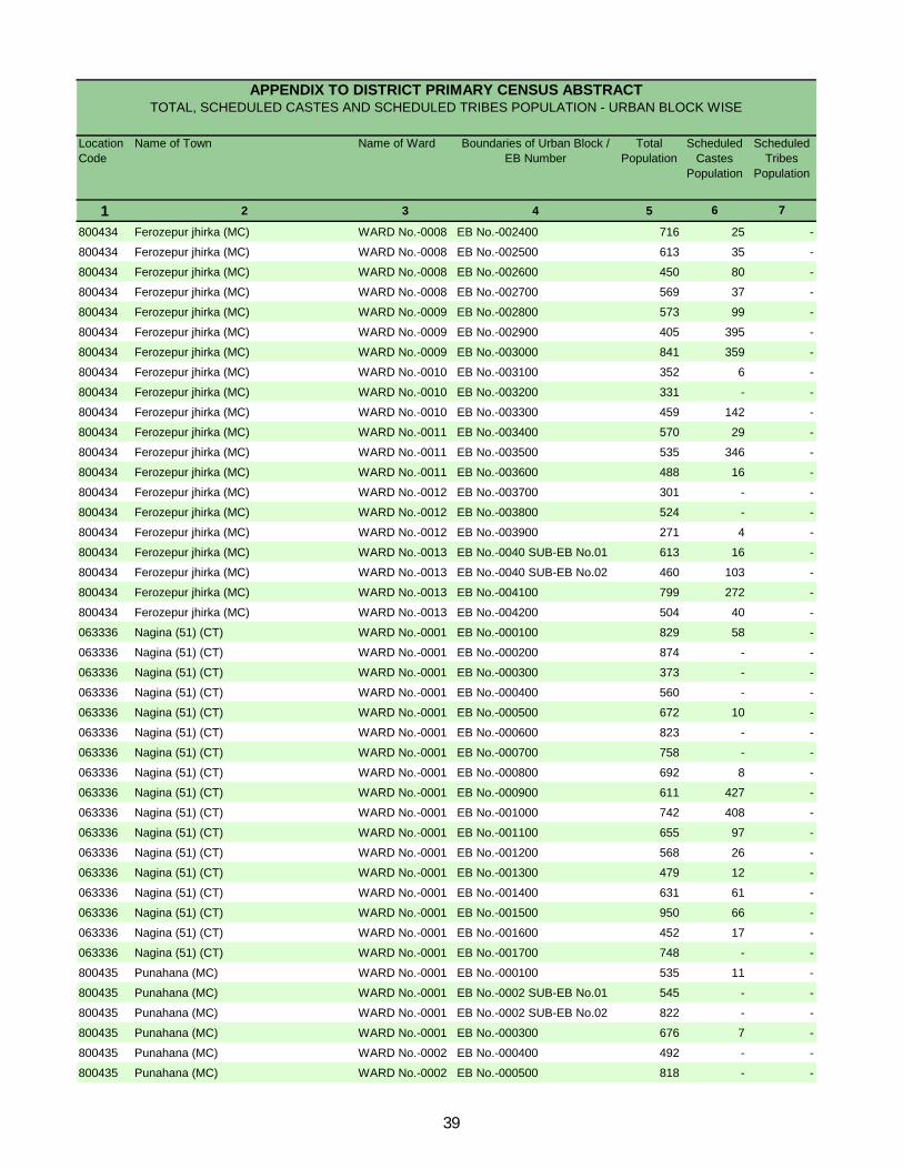
Location Code
Name of Town Name of Ward Boundaries of Urban Block / EB Number
Total Population
Scheduled Castes
Population
Scheduled Tribes
Population
1 2 3 4 5 6 7
APPENDIX TO DISTRICT PRIMARY CENSUS ABSTRACT TOTAL, SCHEDULED CASTES AND SCHEDULED TRIBES POPULATION - URBAN BLOCK WISE
800434 Ferozepur jhirka (MC) WARD No.-0008 EB No.-002400 716 25 -
800434 Ferozepur jhirka (MC) WARD No.-0008 EB No.-002500 613 35 -
800434 Ferozepur jhirka (MC) WARD No.-0008 EB No.-002600 450 80 -
800434 Ferozepur jhirka (MC) WARD No.-0008 EB No.-002700 569 37 -
800434 Ferozepur jhirka (MC) WARD No.-0009 EB No.-002800 573 99 -
800434 Ferozepur jhirka (MC) WARD No.-0009 EB No.-002900 405 395 -
800434 Ferozepur jhirka (MC) WARD No.-0009 EB No.-003000 841 359 -
800434 Ferozepur jhirka (MC) WARD No.-0010 EB No.-003100 352 6 -
800434 Ferozepur jhirka (MC) WARD No.-0010 EB No.-003200 331 - -
800434 Ferozepur jhirka (MC) WARD No.-0010 EB No.-003300 459 142 -
800434 Ferozepur jhirka (MC) WARD No.-0011 EB No.-003400 570 29 -
800434 Ferozepur jhirka (MC) WARD No.-0011 EB No.-003500 535 346 -
800434 Ferozepur jhirka (MC) WARD No.-0011 EB No.-003600 488 16 -
800434 Ferozepur jhirka (MC) WARD No.-0012 EB No.-003700 301 - -
800434 Ferozepur jhirka (MC) WARD No.-0012 EB No.-003800 524 - -
800434 Ferozepur jhirka (MC) WARD No.-0012 EB No.-003900 271 4 -
800434 Ferozepur jhirka (MC) WARD No.-0013 EB No.-0040 SUB-EB No.01 613 16 -
800434 Ferozepur jhirka (MC) WARD No.-0013 EB No.-0040 SUB-EB No.02 460 103 -
800434 Ferozepur jhirka (MC) WARD No.-0013 EB No.-004100 799 272 -
800434 Ferozepur jhirka (MC) WARD No.-0013 EB No.-004200 504 40 -
063336 Nagina (51) (CT) WARD No.-0001 EB No.-000100 829 58 -
063336 Nagina (51) (CT) WARD No.-0001 EB No.-000200 874 - -
063336 Nagina (51) (CT) WARD No.-0001 EB No.-000300 373 - -
063336 Nagina (51) (CT) WARD No.-0001 EB No.-000400 560 - -
063336 Nagina (51) (CT) WARD No.-0001 EB No.-000500 672 10 -
063336 Nagina (51) (CT) WARD No.-0001 EB No.-000600 823 - -
063336 Nagina (51) (CT) WARD No.-0001 EB No.-000700 758 - -
063336 Nagina (51) (CT) WARD No.-0001 EB No.-000800 692 8 -
063336 Nagina (51) (CT) WARD No.-0001 EB No.-000900 611 427 -
063336 Nagina (51) (CT) WARD No.-0001 EB No.-001000 742 408 -
063336 Nagina (51) (CT) WARD No.-0001 EB No.-001100 655 97 -
063336 Nagina (51) (CT) WARD No.-0001 EB No.-001200 568 26 -
063336 Nagina (51) (CT) WARD No.-0001 EB No.-001300 479 12 -
063336 Nagina (51) (CT) WARD No.-0001 EB No.-001400 631 61 -
063336 Nagina (51) (CT) WARD No.-0001 EB No.-001500 950 66 -
063336 Nagina (51) (CT) WARD No.-0001 EB No.-001600 452 17 -
063336 Nagina (51) (CT) WARD No.-0001 EB No.-001700 748 - -
800435 Punahana (MC) WARD No.-0001 EB No.-000100 535 11 -
800435 Punahana (MC) WARD No.-0001 EB No.-0002 SUB-EB No.01 545 - -
800435 Punahana (MC) WARD No.-0001 EB No.-0002 SUB-EB No.02 822 - -
800435 Punahana (MC) WARD No.-0001 EB No.-000300 676 7 -
800435 Punahana (MC) WARD No.-0002 EB No.-000400 492 - -
800435 Punahana (MC) WARD No.-0002 EB No.-000500 818 - -
39
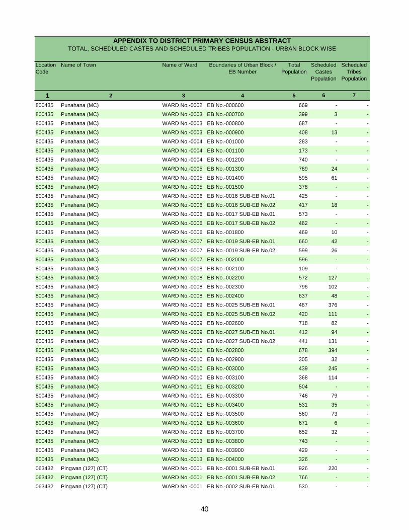
Location Code
Name of Town Name of Ward Boundaries of Urban Block / EB Number
Total Population
Scheduled Castes
Population
Scheduled Tribes
Population
1 2 3 4 5 6 7
APPENDIX TO DISTRICT PRIMARY CENSUS ABSTRACT TOTAL, SCHEDULED CASTES AND SCHEDULED TRIBES POPULATION - URBAN BLOCK WISE
800435 Punahana (MC) WARD No.-0002 EB No.-000600 669 - -
800435 Punahana (MC) WARD No.-0003 EB No.-000700 399 3 -
800435 Punahana (MC) WARD No.-0003 EB No.-000800 687 - -
800435 Punahana (MC) WARD No.-0003 EB No.-000900 408 13 -
800435 Punahana (MC) WARD No.-0004 EB No.-001000 283 - -
800435 Punahana (MC) WARD No.-0004 EB No.-001100 173 - -
800435 Punahana (MC) WARD No.-0004 EB No.-001200 740 - -
800435 Punahana (MC) WARD No.-0005 EB No.-001300 789 24 -
800435 Punahana (MC) WARD No.-0005 EB No.-001400 595 61 -
800435 Punahana (MC) WARD No.-0005 EB No.-001500 378 - -
800435 Punahana (MC) WARD No.-0006 EB No.-0016 SUB-EB No.01 425 - -
800435 Punahana (MC) WARD No.-0006 EB No.-0016 SUB-EB No.02 417 18 -
800435 Punahana (MC) WARD No.-0006 EB No.-0017 SUB-EB No.01 573 - -
800435 Punahana (MC) WARD No.-0006 EB No.-0017 SUB-EB No.02 462 - -
800435 Punahana (MC) WARD No.-0006 EB No.-001800 469 10 -
800435 Punahana (MC) WARD No.-0007 EB No.-0019 SUB-EB No.01 660 42 -
800435 Punahana (MC) WARD No.-0007 EB No.-0019 SUB-EB No.02 599 26 -
800435 Punahana (MC) WARD No.-0007 EB No.-002000 596 - -
800435 Punahana (MC) WARD No.-0008 EB No.-002100 109 - -
800435 Punahana (MC) WARD No.-0008 EB No.-002200 572 127 -
800435 Punahana (MC) WARD No.-0008 EB No.-002300 796 102 -
800435 Punahana (MC) WARD No.-0008 EB No.-002400 637 48 -
800435 Punahana (MC) WARD No.-0009 EB No.-0025 SUB-EB No.01 467 376 -
800435 Punahana (MC) WARD No.-0009 EB No.-0025 SUB-EB No.02 420 111 -
800435 Punahana (MC) WARD No.-0009 EB No.-002600 718 82 -
800435 Punahana (MC) WARD No.-0009 EB No.-0027 SUB-EB No.01 412 94 -
800435 Punahana (MC) WARD No.-0009 EB No.-0027 SUB-EB No.02 441 131 -
800435 Punahana (MC) WARD No.-0010 EB No.-002800 678 394 -
800435 Punahana (MC) WARD No.-0010 EB No.-002900 305 32 -
800435 Punahana (MC) WARD No.-0010 EB No.-003000 439 245 -
800435 Punahana (MC) WARD No.-0010 EB No.-003100 368 114 -
800435 Punahana (MC) WARD No.-0011 EB No.-003200 504 - -
800435 Punahana (MC) WARD No.-0011 EB No.-003300 746 79 -
800435 Punahana (MC) WARD No.-0011 EB No.-003400 531 35 -
800435 Punahana (MC) WARD No.-0012 EB No.-003500 560 73 -
800435 Punahana (MC) WARD No.-0012 EB No.-003600 671 6 -
800435 Punahana (MC) WARD No.-0012 EB No.-003700 652 32 -
800435 Punahana (MC) WARD No.-0013 EB No.-003800 743 - -
800435 Punahana (MC) WARD No.-0013 EB No.-003900 429 - -
800435 Punahana (MC) WARD No.-0013 EB No.-004000 326 - -
063432 Pingwan (127) (CT) WARD No.-0001 EB No.-0001 SUB-EB No.01 926 220 -
063432 Pingwan (127) (CT) WARD No.-0001 EB No.-0001 SUB-EB No.02 766 - -
063432 Pingwan (127) (CT) WARD No.-0001 EB No.-0002 SUB-EB No.01 530 - -
40
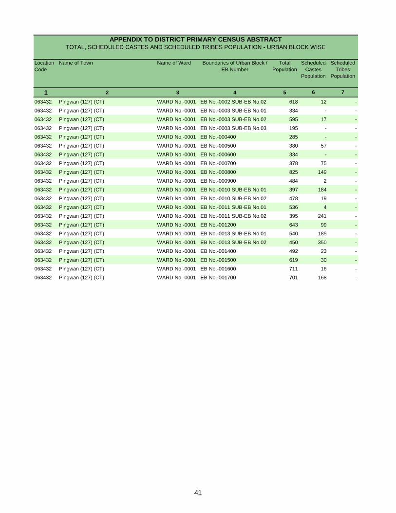
Location Code
Name of Town Name of Ward Boundaries of Urban Block / EB Number
Total Population
Scheduled Castes
Population
Scheduled Tribes
Population
1 2 3 4 5 6 7
APPENDIX TO DISTRICT PRIMARY CENSUS ABSTRACT TOTAL, SCHEDULED CASTES AND SCHEDULED TRIBES POPULATION - URBAN BLOCK WISE
063432 Pingwan (127) (CT) WARD No.-0001 EB No.-0002 SUB-EB No.02 618 12 -
063432 Pingwan (127) (CT) WARD No.-0001 EB No.-0003 SUB-EB No.01 334 - -
063432 Pingwan (127) (CT) WARD No.-0001 EB No.-0003 SUB-EB No.02 595 17 -
063432 Pingwan (127) (CT) WARD No.-0001 EB No.-0003 SUB-EB No.03 195 - -
063432 Pingwan (127) (CT) WARD No.-0001 EB No.-000400 285 - -
063432 Pingwan (127) (CT) WARD No.-0001 EB No.-000500 380 57 -
063432 Pingwan (127) (CT) WARD No.-0001 EB No.-000600 334 - -
063432 Pingwan (127) (CT) WARD No.-0001 EB No.-000700 378 75 -
063432 Pingwan (127) (CT) WARD No.-0001 EB No.-000800 825 149 -
063432 Pingwan (127) (CT) WARD No.-0001 EB No.-000900 484 2 -
063432 Pingwan (127) (CT) WARD No.-0001 EB No.-0010 SUB-EB No.01 397 184 -
063432 Pingwan (127) (CT) WARD No.-0001 EB No.-0010 SUB-EB No.02 478 19 -
063432 Pingwan (127) (CT) WARD No.-0001 EB No.-0011 SUB-EB No.01 536 4 -
063432 Pingwan (127) (CT) WARD No.-0001 EB No.-0011 SUB-EB No.02 395 241 -
063432 Pingwan (127) (CT) WARD No.-0001 EB No.-001200 643 99 -
063432 Pingwan (127) (CT) WARD No.-0001 EB No.-0013 SUB-EB No.01 540 185 -
063432 Pingwan (127) (CT) WARD No.-0001 EB No.-0013 SUB-EB No.02 450 350 -
063432 Pingwan (127) (CT) WARD No.-0001 EB No.-001400 492 23 -
063432 Pingwan (127) (CT) WARD No.-0001 EB No.-001500 619 30 -
063432 Pingwan (127) (CT) WARD No.-0001 EB No.-001600 711 16 -
063432 Pingwan (127) (CT) WARD No.-0001 EB No.-001700 701 168 -
41

Primary Census Abstract for Scheduled Castes (SC)
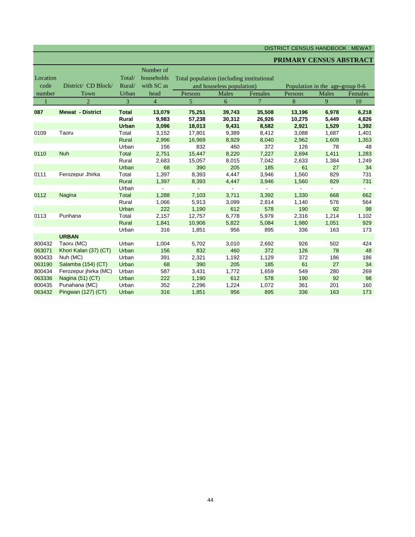
DISTRICT CENSUS HANDBOOK : MEWAT
PRIMARY CENSUS ABSTRACT
Persons Males Females Persons Males Females1 2 3 4 5 6 7 8 9 10
087 Mewat - District Total 13,079 75,251 39,743 35,508 13,196 6,978 6,218 Rural 9,983 57,238 30,312 26,926 10,275 5,449 4,826 Urban 3,096 18,013 9,431 8,582 2,921 1,529 1,392
0109 Taoru Total 3,152 17,801 9,389 8,412 3,088 1,687 1,401 Rural 2,996 16,969 8,929 8,040 2,962 1,609 1,353 Urban 156 832 460 372 126 78 48
0110 Nuh Total 2,751 15,447 8,220 7,227 2,694 1,411 1,283 Rural 2,683 15,057 8,015 7,042 2,633 1,384 1,249 Urban 68 390 205 185 61 27 34
0111 Ferozepur Jhirka Total 1,397 8,393 4,447 3,946 1,560 829 731 Rural 1,397 8,393 4,447 3,946 1,560 829 731 Urban - - - - - - -
0112 Nagina Total 1,288 7,103 3,711 3,392 1,330 668 662 Rural 1,066 5,913 3,099 2,814 1,140 576 564 Urban 222 1,190 612 578 190 92 98
0113 Punhana Total 2,157 12,757 6,778 5,979 2,316 1,214 1,102 Rural 1,841 10,906 5,822 5,084 1,980 1,051 929 Urban 316 1,851 956 895 336 163 173
URBAN800432 Taoru (MC) Urban 1,004 5,702 3,010 2,692 926 502 424 063071 Khori Kalan (37) (CT) Urban 156 832 460 372 126 78 48 800433 Nuh (MC) Urban 391 2,321 1,192 1,129 372 186 186 063190 Salamba (154) (CT) Urban 68 390 205 185 61 27 34 800434 Ferozepur jhirka (MC) Urban 587 3,431 1,772 1,659 549 280 269 063336 Nagina (51) (CT) Urban 222 1,190 612 578 190 92 98 800435 Punahana (MC) Urban 352 2,296 1,224 1,072 361 201 160 063432 Pingwan (127) (CT) Urban 316 1,851 956 895 336 163 173
Population in the age-group 0-6Location
code number
District/ CD Block/ Town
Total/ Rural/ Urban
Number of households with SC as
head
Total population (including institutional and houseless population)
44
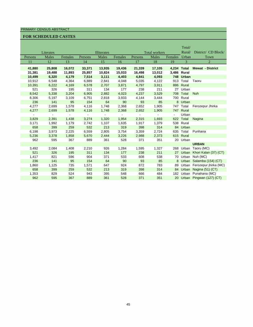
PRIMARY CENSUS ABSTRACT
FOR SCHEDULED CASTES
Persons Males Females Persons Males Females Persons Males Females11 12 13 14 15 16 17 18 19 3 2
41,880 25,808 16,072 33,371 13,935 19,436 21,339 17,105 4,234 Total Mewat - District31,381 19,488 11,893 25,857 10,824 15,033 16,498 13,012 3,486 Rural10,499 6,320 4,179 7,514 3,111 4,403 4,841 4,093 748 Urban10,912 6,548 4,364 6,889 2,841 4,048 5,035 4,122 913 Total Taoru10,391 6,222 4,169 6,578 2,707 3,871 4,797 3,911 886 Rural
521 326 195 311 134 177 238 211 27 Urban8,542 5,338 3,204 6,905 2,882 4,023 4,237 3,529 708 Total Nuh8,306 5,197 3,109 6,751 2,818 3,933 4,144 3,444 700 Rural
236 141 95 154 64 90 93 85 8 Urban4,277 2,699 1,578 4,116 1,748 2,368 2,652 1,905 747 Total Ferozepur Jhirka4,277 2,699 1,578 4,116 1,748 2,368 2,652 1,905 747 Rural
- - - - - - - - - Urban3,829 2,391 1,438 3,274 1,320 1,954 2,315 1,693 622 Total Nagina3,171 1,992 1,179 2,742 1,107 1,635 1,917 1,379 538 Rural
658 399 259 532 213 319 398 314 84 Urban6,198 3,973 2,225 6,559 2,805 3,754 3,359 2,724 635 Total Punhana5,236 3,378 1,858 5,670 2,444 3,226 2,988 2,373 615 Rural
962 595 367 889 361 528 371 351 20 UrbanURBAN
3,492 2,084 1,408 2,210 926 1,284 1,595 1,327 268 Urban Taoru (MC)521 326 195 311 134 177 238 211 27 Urban Khori Kalan (37) (CT)
1,417 821 596 904 371 533 608 538 70 Urban Nuh (MC)236 141 95 154 64 90 93 85 8 Urban Salamba (154) (CT)
1,860 1,125 735 1,571 647 924 872 783 89 Urban Ferozepur jhirka (MC)658 399 259 532 213 319 398 314 84 Urban Nagina (51) (CT)
1,353 829 524 943 395 548 666 484 182 Urban Punahana (MC)962 595 367 889 361 528 371 351 20 Urban Pingwan (127) (CT)
Literates Illiterates District/ CD Block/ Town
Total/ Rural/ Urban
Total workers
45
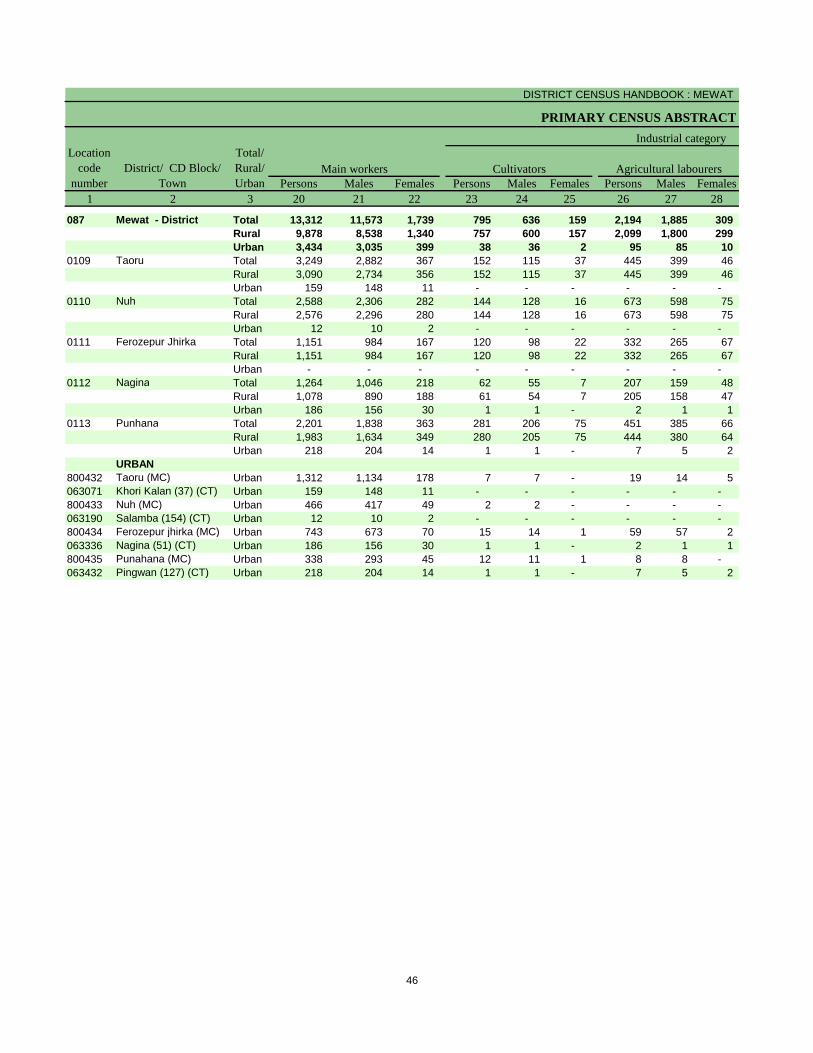
DISTRICT CENSUS HANDBOOK : MEWAT
PRIMARY CENSUS ABSTRACT
Persons Males Females Persons Males Females Persons Males Females1 2 3 20 21 22 23 24 25 26 27 28
087 Mewat - District Total 13,312 11,573 1,739 795 636 159 2,194 1,885 309 Rural 9,878 8,538 1,340 757 600 157 2,099 1,800 299 Urban 3,434 3,035 399 38 36 2 95 85 10
0109 Taoru Total 3,249 2,882 367 152 115 37 445 399 46 Rural 3,090 2,734 356 152 115 37 445 399 46 Urban 159 148 11 - - - - - -
0110 Nuh Total 2,588 2,306 282 144 128 16 673 598 75 Rural 2,576 2,296 280 144 128 16 673 598 75 Urban 12 10 2 - - - - - -
0111 Ferozepur Jhirka Total 1,151 984 167 120 98 22 332 265 67 Rural 1,151 984 167 120 98 22 332 265 67 Urban - - - - - - - - -
0112 Nagina Total 1,264 1,046 218 62 55 7 207 159 48 Rural 1,078 890 188 61 54 7 205 158 47 Urban 186 156 30 1 1 - 2 1 1
0113 Punhana Total 2,201 1,838 363 281 206 75 451 385 66 Rural 1,983 1,634 349 280 205 75 444 380 64 Urban 218 204 14 1 1 - 7 5 2
URBAN800432 Taoru (MC) Urban 1,312 1,134 178 7 7 - 19 14 5 063071 Khori Kalan (37) (CT) Urban 159 148 11 - - - - - - 800433 Nuh (MC) Urban 466 417 49 2 2 - - - - 063190 Salamba (154) (CT) Urban 12 10 2 - - - - - - 800434 Ferozepur jhirka (MC) Urban 743 673 70 15 14 1 59 57 2 063336 Nagina (51) (CT) Urban 186 156 30 1 1 - 2 1 1 800435 Punahana (MC) Urban 338 293 45 12 11 1 8 8 - 063432 Pingwan (127) (CT) Urban 218 204 14 1 1 - 7 5 2
CultivatorsLocation
code number
District/ CD Block/ Town
Total/ Rural/ Urban
Industrial category
Agricultural labourersMain workers
46
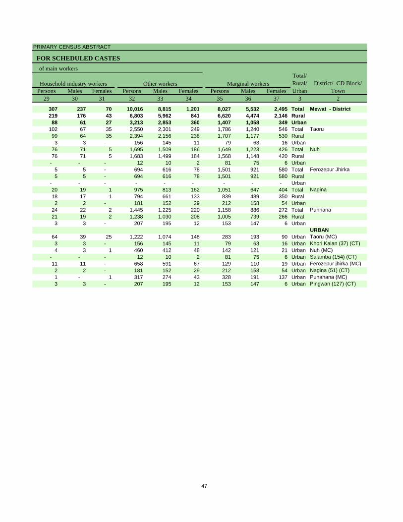
PRIMARY CENSUS ABSTRACT
FOR SCHEDULED CASTES
Persons Males Females Persons Males Females Persons Males Females29 30 31 32 33 34 35 36 37 3 2
307 237 70 10,016 8,815 1,201 8,027 5,532 2,495 Total Mewat - District219 176 43 6,803 5,962 841 6,620 4,474 2,146 Rural88 61 27 3,213 2,853 360 1,407 1,058 349 Urban
102 67 35 2,550 2,301 249 1,786 1,240 546 Total Taoru99 64 35 2,394 2,156 238 1,707 1,177 530 Rural3 3 - 156 145 11 79 63 16 Urban
76 71 5 1,695 1,509 186 1,649 1,223 426 Total Nuh76 71 5 1,683 1,499 184 1,568 1,148 420 Rural
- - - 12 10 2 81 75 6 Urban5 5 - 694 616 78 1,501 921 580 Total Ferozepur Jhirka5 5 - 694 616 78 1,501 921 580 Rural
- - - - - - - - - Urban20 19 1 975 813 162 1,051 647 404 Total Nagina18 17 1 794 661 133 839 489 350 Rural2 2 - 181 152 29 212 158 54 Urban
24 22 2 1,445 1,225 220 1,158 886 272 Total Punhana21 19 2 1,238 1,030 208 1,005 739 266 Rural3 3 - 207 195 12 153 147 6 Urban
URBAN64 39 25 1,222 1,074 148 283 193 90 Urban Taoru (MC)3 3 - 156 145 11 79 63 16 Urban Khori Kalan (37) (CT)4 3 1 460 412 48 142 121 21 Urban Nuh (MC)
- - - 12 10 2 81 75 6 Urban Salamba (154) (CT)11 11 - 658 591 67 129 110 19 Urban Ferozepur jhirka (MC)2 2 - 181 152 29 212 158 54 Urban Nagina (51) (CT)1 - 1 317 274 43 328 191 137 Urban Punahana (MC)3 3 - 207 195 12 153 147 6 Urban Pingwan (127) (CT)
Household industry workers Marginal workersTotal/ Rural/ Urban
District/ CD Block/ Town
Other workers
of main workers
47
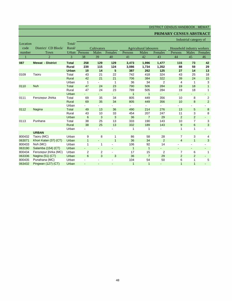
DISTRICT CENSUS HANDBOOK : MEWAT
PRIMARY CENSUS ABSTRACT
Persons Males Females Persons Males Females Persons Males Females1 2 3 38 39 40 41 42 43 44 45 46
087 Mewat - District Total 258 129 129 3,473 1,996 1,477 115 73 42 Rural 239 115 124 3,086 1,734 1,352 88 59 29 Urban 19 14 5 387 262 125 27 14 13
0109 Taoru Total 43 21 22 742 418 324 43 25 18 Rural 42 21 21 706 384 322 39 24 15 Urban 1 - 1 36 34 2 4 1 3
0110 Nuh Total 47 24 23 790 506 284 19 18 1 Rural 47 24 23 789 505 284 19 18 1 Urban - - - 1 1 - - - -
0111 Ferozepur Jhirka Total 69 35 34 805 449 356 10 8 2 Rural 69 35 34 805 449 356 10 8 2 Urban - - - - - - - - -
0112 Nagina Total 49 13 36 490 214 276 13 5 8 Rural 43 10 33 454 207 247 11 3 8 Urban 6 3 3 36 7 29 2 2 -
0113 Punhana Total 38 25 13 333 190 143 10 7 3 Rural 38 25 13 332 189 143 9 6 3 Urban - - - 1 1 - 1 1 -
URBAN800432 Taoru (MC) Urban 9 8 1 86 58 28 7 3 4 063071 Khori Kalan (37) (CT) Urban 1 - 1 36 34 2 4 1 3 800433 Nuh (MC) Urban 1 1 - 106 92 14 - - - 063190 Salamba (154) (CT) Urban - - - 1 1 - - - - 800434 Ferozepur jhirka (MC) Urban 2 2 - 17 15 2 7 6 1 063336 Nagina (51) (CT) Urban 6 3 3 36 7 29 2 2 - 800435 Punahana (MC) Urban - - - 104 54 50 6 1 5 063432 Pingwan (127) (CT) Urban - - - 1 1 - 1 1 -
Industrial category of
Cultivators Household industry workersLocation
code number
District/ CD Block/ Town
Total/ Rural/ Urban
Agricultural labourers
48
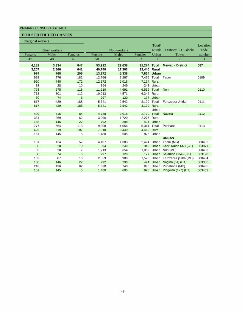
PRIMARY CENSUS ABSTRACT
FOR SCHEDULED CASTES
Persons Males Females Persons Males Females47 48 49 50 51 52 3 2 1
4,181 3,334 847 53,912 22,638 31,274 Total Mewat - District 0873,207 2,566 641 40,740 17,300 23,440 Rural
974 768 206 13,172 5,338 7,834 Urban958 776 182 12,766 5,267 7,499 Total Taoru 0109920 748 172 12,172 5,018 7,154 Rural38 28 10 594 249 345 Urban
793 675 118 11,210 4,691 6,519 Total Nuh 0110713 601 112 10,913 4,571 6,342 Rural80 74 6 297 120 177 Urban
617 429 188 5,741 2,542 3,199 Total Ferozepur Jhirka 0111617 429 188 5,741 2,542 3,199 Rural- - - - - - Urban499 415 84 4,788 2,018 2,770 Total Nagina 0112331 269 62 3,996 1,720 2,276 Rural168 146 22 792 298 494 Urban777 664 113 9,398 4,054 5,344 Total Punhana 0113626 519 107 7,918 3,449 4,469 Rural151 145 6 1,480 605 875 Urban
URBAN181 124 57 4,107 1,683 2,424 Urban Taoru (MC) 80043238 28 10 594 249 345 Urban Khori Kalan (37) (CT) 06307135 28 7 1,713 654 1,059 Urban Nuh (MC) 80043380 74 6 297 120 177 Urban Salamba (154) (CT) 063190
103 87 16 2,559 989 1,570 Urban Ferozepur jhirka (MC) 800434168 146 22 792 298 494 Urban Nagina (51) (CT) 063336218 136 82 1,630 740 890 Urban Punahana (MC) 800435151 145 6 1,480 605 875 Urban Pingwan (127) (CT) 063432
marginal workers
District/ CD Block/ Town
Location code
numberOther workers Non-workers
Total/ Rural/ Urban
49

Primary Census Abstract for
Scheduled Tribes (ST)
__________________________________________________________
** There is no Scheduled Tribes notified **

Rural PCA-C.D. blocks wise Village Primary Census
Abstract

DISTRICT CENSUS HANDBOOK : MEWAT
VILLAGE PRIMARY
Persons Males Females Persons Males Females1 2 3 4 5 6 7 8 9 10
0109 Taoru (Total) 21,398.00 21,281 1,44,179 75,783 68,396 31,948 17,009 14,939 0109 Taoru (Rural) 21,048.00 20,117 1,38,172 72,575 65,597 30,827 16,414 14,413 0109 Taoru (Urban) 350.00 1,164 6,007 3,208 2,799 1,121 595 526
RURAL062990 Kota Khandewla(1) 534.00 260 1,829 1,004 825 320 183 137 062991 Gangani(12) 634.00 26 154 77 77 35 17 18 062992 Mohmmadpur Ahir(13) 623.00 851 5,091 2,675 2,416 882 470 412 062993 Sarai(11) 126.00 157 1,190 613 577 219 113 106 062994 Dadu(10) 264.00 126 667 359 308 84 52 32 062995 Bissar Akbarpur(2) 915.00 511 3,286 1,745 1,541 534 284 250 062996 Para(5) 346.00 148 808 431 377 102 58 44 062997 Hassanpur Taoru (7) 395.00 532 3,022 1,644 1,378 368 225 143 062998 Kalwari(6) 226.00 519 2,751 1,462 1,289 337 180 157 062999 Sheikhpur(28) 120.00 79 371 208 163 49 33 16 063000 Sabras(27) 163.00 220 1,457 759 698 328 171 157 063001 Kharak Taoru (23) 62.00 34 220 112 108 43 24 19 063002 Sunthaka(26) 77.00 12 72 39 33 13 8 5 063003 Beri Nisfi Taoru(8) 88.00 80 531 293 238 128 70 58 063004 Beri Nisfi Sohna (9) 87.00 102 740 392 348 196 95 101 063005 Bamrauli(25) 74.00 39 276 136 140 56 27 29 063006 Jafrabad(24) 157.00 171 1,221 609 612 258 128 130 063007 Nanduki(22) 39.00 31 171 85 86 17 9 8 063008 Bhango(16) 515.00 249 1,678 914 764 395 216 179 063009 Kharak Sohna(15) 260.00 144 907 476 431 241 131 110 063010 Jalalpur Sohna(14) 209.00 28 223 110 113 53 26 27 063011 Chehalka(17) 260.00 565 4,039 2,124 1,915 1,064 533 531 063012 Sondh(18) 991.00 520 3,216 1,663 1,553 674 352 322 063013 Dalawas(77) 67.00 221 1,659 847 812 356 182 174 063014 Kuliaka(76) 147.00 179 1,345 717 628 323 189 134 063015 Goela (19) 337.00 217 1,527 825 702 347 204 143 063016 Deengarheri (21) 214.00 161 931 493 438 180 92 88 063017 Sonika (20) 73.00 43 260 128 132 68 31 37 063018 Guddhi (29) 295.00 213 1,459 757 702 293 160 133 063019 Jhamuwas (31) 331.00 243 1,442 763 679 179 107 72 063020 Fatehpur (30) 294.00 152 885 459 426 142 79 63 063021 Jaurasi (32) 715.00 767 4,604 2,415 2,189 547 304 243 063022 Uton (33) 324.00 248 1,590 850 740 339 183 156 063023 Rathiwas (34) 391.00 493 2,794 1,475 1,319 421 254 167 063024 Rangala (35) 464.00 404 1,920 1,051 869 330 176 154 063025 Khori Khurd(36) 177.00 102 629 309 320 129 60 69 063026 Sunari (40) 259.00 403 2,916 1,506 1,410 739 392 347 063027 Atitka(38) 152.00 39 301 160 141 70 38 32 063028 Chundhika(39) 99.00 135 971 499 472 236 127 109 063029 Nijampur Taoru (43) 222.00 329 2,934 1,523 1,411 740 399 341 063030 Ghoraka(41) 130.00 5 33 17 16 8 5 3 063031 Kalarpuri(42) 159.00 176 1,001 521 480 119 66 53 063032 Didhara (44) 177.00 325 2,281 1,195 1,086 421 232 189 063033 Taoru (Rural)(Part) (64) 665.00 37 262 144 118 50 31 19 063034 Gogjaka (75) 251.00 200 1,173 642 531 233 141 92 063035 Padheni (78) 308.00 567 3,331 1,748 1,583 658 356 302 063036 Shikarpur (74) 180.00 561 4,065 2,137 1,928 1,012 537 475 063037 Raheri (73) 185.00 344 2,540 1,373 1,167 696 372 324 063038 Gawarka (65) 197.00 294 2,084 1,075 1,009 511 265 246 063039 Bharangpur(45) 119.00 170 1,395 738 657 340 185 155 063040 Raniaki(50) 154.00 248 1,823 930 893 429 216 213
Name of Village
Location code
number
Total population (including institutional and houseless
population)Area of
Village in hectares
Number of households
C D Block -
Population in the age-group 0-6
54
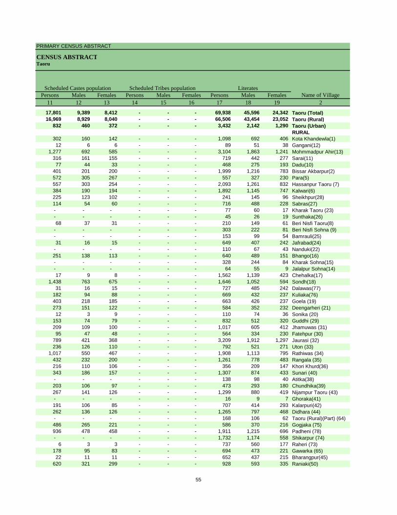
PRIMARY CENSUS ABSTRACT
CENSUS ABSTRACTTaoru
Persons Males Females Persons Males Females Persons Males Females11 12 13 14 15 16 17 18 19 2
17,801 9,389 8,412 - - - 69,938 45,596 24,342 Taoru (Total)16,969 8,929 8,040 - - - 66,506 43,454 23,052 Taoru (Rural)
832 460 372 - - - 3,432 2,142 1,290 Taoru (Urban)RURAL
302 160 142 - - - 1,098 692 406 Kota Khandewla(1)12 6 6 - - - 89 51 38 Gangani(12)
1,277 692 585 - - - 3,104 1,863 1,241 Mohmmadpur Ahir(13)316 161 155 - - - 719 442 277 Sarai(11)77 44 33 - - - 468 275 193 Dadu(10)
401 201 200 - - - 1,999 1,216 783 Bissar Akbarpur(2)572 305 267 - - - 557 327 230 Para(5)557 303 254 - - - 2,093 1,261 832 Hassanpur Taoru (7)384 190 194 - - - 1,892 1,145 747 Kalwari(6)225 123 102 - - - 241 145 96 Sheikhpur(28)114 54 60 - - - 716 488 228 Sabras(27)- - - - - - 77 60 17 Kharak Taoru (23)- - - - - - 45 26 19 Sunthaka(26)68 37 31 - - - 210 149 61 Beri Nisfi Taoru(8)
- - - - - - 303 222 81 Beri Nisfi Sohna (9)- - - - - - 153 99 54 Bamrauli(25)31 16 15 - - - 649 407 242 Jafrabad(24)
- - - - - - 110 67 43 Nanduki(22)251 138 113 - - - 640 489 151 Bhango(16)- - - - - - 328 244 84 Kharak Sohna(15)- - - - - - 64 55 9 Jalalpur Sohna(14)17 9 8 - - - 1,562 1,139 423 Chehalka(17)
1,438 763 675 - - - 1,646 1,052 594 Sondh(18)31 16 15 - - - 727 485 242 Dalawas(77)
182 94 88 - - - 669 432 237 Kuliaka(76)403 218 185 - - - 663 426 237 Goela (19)273 151 122 - - - 584 352 232 Deengarheri (21)12 3 9 - - - 110 74 36 Sonika (20)
153 74 79 - - - 832 512 320 Guddhi (29)209 109 100 - - - 1,017 605 412 Jhamuwas (31)95 47 48 - - - 564 334 230 Fatehpur (30)
789 421 368 - - - 3,209 1,912 1,297 Jaurasi (32)236 126 110 - - - 792 521 271 Uton (33)
1,017 550 467 - - - 1,908 1,113 795 Rathiwas (34)432 232 200 - - - 1,261 778 483 Rangala (35)216 110 106 - - - 356 209 147 Khori Khurd(36)343 186 157 - - - 1,307 874 433 Sunari (40)- - - - - - 138 98 40 Atitka(38)203 106 97 - - - 473 293 180 Chundhika(39)267 141 126 - - - 1,299 880 419 Nijampur Taoru (43)- - - - - - 16 9 7 Ghoraka(41)191 106 85 - - - 707 414 293 Kalarpuri(42)262 136 126 - - - 1,265 797 468 Didhara (44)- - - - - - 168 106 62 Taoru (Rural)(Part) (64)486 265 221 - - - 586 370 216 Gogjaka (75)936 478 458 - - - 1,911 1,215 696 Padheni (78)- - - - - - 1,732 1,174 558 Shikarpur (74)
6 3 3 - - - 737 560 177 Raheri (73)178 95 83 - - - 694 473 221 Gawarka (65)22 11 11 - - - 652 437 215 Bharangpur(45)
620 321 299 - - - 928 593 335 Raniaki(50)
Name of VillageLiteratesScheduled Castes population Scheduled Tribes population
55
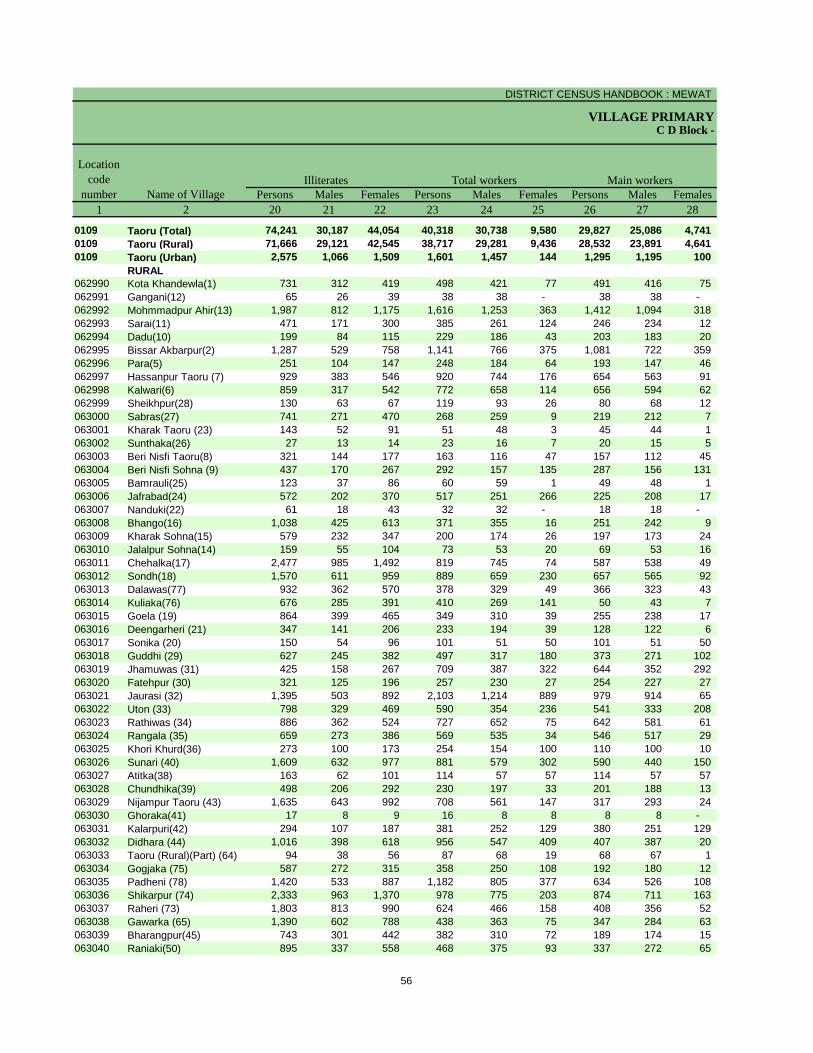
DISTRICT CENSUS HANDBOOK : MEWAT
VILLAGE PRIMARYC D Block -
Persons Males Females Persons Males Females Persons Males Females1 2 20 21 22 23 24 25 26 27 28
0109 Taoru (Total) 74,241 30,187 44,054 40,318 30,738 9,580 29,827 25,086 4,741 0109 Taoru (Rural) 71,666 29,121 42,545 38,717 29,281 9,436 28,532 23,891 4,641 0109 Taoru (Urban) 2,575 1,066 1,509 1,601 1,457 144 1,295 1,195 100
RURAL062990 Kota Khandewla(1) 731 312 419 498 421 77 491 416 75 062991 Gangani(12) 65 26 39 38 38 - 38 38 - 062992 Mohmmadpur Ahir(13) 1,987 812 1,175 1,616 1,253 363 1,412 1,094 318 062993 Sarai(11) 471 171 300 385 261 124 246 234 12 062994 Dadu(10) 199 84 115 229 186 43 203 183 20 062995 Bissar Akbarpur(2) 1,287 529 758 1,141 766 375 1,081 722 359 062996 Para(5) 251 104 147 248 184 64 193 147 46 062997 Hassanpur Taoru (7) 929 383 546 920 744 176 654 563 91 062998 Kalwari(6) 859 317 542 772 658 114 656 594 62 062999 Sheikhpur(28) 130 63 67 119 93 26 80 68 12 063000 Sabras(27) 741 271 470 268 259 9 219 212 7 063001 Kharak Taoru (23) 143 52 91 51 48 3 45 44 1 063002 Sunthaka(26) 27 13 14 23 16 7 20 15 5 063003 Beri Nisfi Taoru(8) 321 144 177 163 116 47 157 112 45 063004 Beri Nisfi Sohna (9) 437 170 267 292 157 135 287 156 131 063005 Bamrauli(25) 123 37 86 60 59 1 49 48 1 063006 Jafrabad(24) 572 202 370 517 251 266 225 208 17 063007 Nanduki(22) 61 18 43 32 32 - 18 18 - 063008 Bhango(16) 1,038 425 613 371 355 16 251 242 9 063009 Kharak Sohna(15) 579 232 347 200 174 26 197 173 24 063010 Jalalpur Sohna(14) 159 55 104 73 53 20 69 53 16 063011 Chehalka(17) 2,477 985 1,492 819 745 74 587 538 49 063012 Sondh(18) 1,570 611 959 889 659 230 657 565 92 063013 Dalawas(77) 932 362 570 378 329 49 366 323 43 063014 Kuliaka(76) 676 285 391 410 269 141 50 43 7 063015 Goela (19) 864 399 465 349 310 39 255 238 17 063016 Deengarheri (21) 347 141 206 233 194 39 128 122 6 063017 Sonika (20) 150 54 96 101 51 50 101 51 50 063018 Guddhi (29) 627 245 382 497 317 180 373 271 102 063019 Jhamuwas (31) 425 158 267 709 387 322 644 352 292 063020 Fatehpur (30) 321 125 196 257 230 27 254 227 27 063021 Jaurasi (32) 1,395 503 892 2,103 1,214 889 979 914 65 063022 Uton (33) 798 329 469 590 354 236 541 333 208 063023 Rathiwas (34) 886 362 524 727 652 75 642 581 61 063024 Rangala (35) 659 273 386 569 535 34 546 517 29 063025 Khori Khurd(36) 273 100 173 254 154 100 110 100 10 063026 Sunari (40) 1,609 632 977 881 579 302 590 440 150 063027 Atitka(38) 163 62 101 114 57 57 114 57 57 063028 Chundhika(39) 498 206 292 230 197 33 201 188 13 063029 Nijampur Taoru (43) 1,635 643 992 708 561 147 317 293 24 063030 Ghoraka(41) 17 8 9 16 8 8 8 8 - 063031 Kalarpuri(42) 294 107 187 381 252 129 380 251 129 063032 Didhara (44) 1,016 398 618 956 547 409 407 387 20 063033 Taoru (Rural)(Part) (64) 94 38 56 87 68 19 68 67 1 063034 Gogjaka (75) 587 272 315 358 250 108 192 180 12 063035 Padheni (78) 1,420 533 887 1,182 805 377 634 526 108 063036 Shikarpur (74) 2,333 963 1,370 978 775 203 874 711 163 063037 Raheri (73) 1,803 813 990 624 466 158 408 356 52 063038 Gawarka (65) 1,390 602 788 438 363 75 347 284 63 063039 Bharangpur(45) 743 301 442 382 310 72 189 174 15 063040 Raniaki(50) 895 337 558 468 375 93 337 272 65
Name of Village
Location code
numberIlliterates Total workers Main workers
56
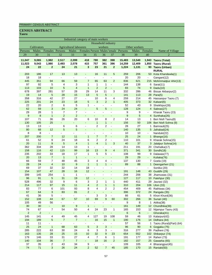
PRIMARY CENSUS ABSTRACT
CENSUS ABSTRACTTaoru
Persons Males Females Persons Males Females PersonsMalesFemales Persons Males Females29 30 31 32 33 34 35 36 37 38 39 40 2
11,047 9,065 1,982 2,517 2,099 418 780 382 398 15,483 13,540 1,943 Taoru (Total)11,023 9,043 1,980 2,493 2,078 415 757 361 396 14,259 12,409 1,850 Taoru (Rural)
24 22 2 24 21 3 23 21 2 1,224 1,131 93 Taoru (Urban)RURAL
203 186 17 13 13 - 16 11 5 259 206 53 Kota Khandewla(1)18 18 - - - - - - - 20 20 - Gangani(12)
445 351 94 66 59 7 65 63 2 836 621 215 Mohmmadpur Ahir(13)97 92 5 4 3 1 1 1 - 144 138 6 Sarai(11)
113 103 10 5 4 1 2 2 - 83 74 9 Dadu(10)678 397 281 57 28 29 14 11 3 332 286 46 Bissar Akbarpur(2)19 14 5 28 15 13 5 5 - 141 113 28 Para(5)
358 316 42 27 27 - 10 6 4 259 214 45 Hassanpur Taoru (7)225 201 24 23 18 5 3 2 1 405 373 32 Kalwari(6)22 20 2 6 5 1 - - - 52 43 9 Sheikhpur(28)62 59 3 24 24 - 5 5 - 128 124 4 Sabras(27)29 28 1 7 7 - - - - 9 9 - Kharak Taoru (23)9 8 1 2 2 - - - - 9 5 4 Sunthaka(26)
107 71 36 26 20 6 10 8 2 14 13 1 Beri Nisfi Taoru(8)130 105 25 - - - 1 1 - 156 50 106 Beri Nisfi Sohna (9)13 13 - 6 6 - 2 2 - 28 27 1 Bamrauli(25)80 68 12 5 5 - - - - 140 135 5 Jafrabad(24)8 8 - - - - - - - 10 10 - Nanduki(22)
207 200 7 12 11 1 7 7 - 25 24 1 Bhango(16)61 52 9 24 18 6 2 2 - 110 101 9 Kharak Sohna(15)20 11 9 5 4 1 4 1 3 40 37 3 Jalalpur Sohna(14)
362 334 28 14 13 1 - - - 211 191 20 Chehalka(17)158 116 42 115 99 16 13 9 4 371 341 30 Sondh(18)235 202 33 18 17 1 5 5 - 108 99 9 Dalawas(77)20 13 7 1 1 - - - - 29 29 - Kuliaka(76)66 59 7 48 45 3 4 4 - 137 130 7 Goela (19)28 24 4 10 9 1 1 1 - 89 88 1 Deengarheri (21)69 37 32 32 14 18 - - - - - - Sonika (20)
154 107 47 28 16 12 - - - 191 148 43 Guddhi (29)399 145 254 1 1 - - - - 244 206 38 Jhamuwas (31)96 91 5 31 19 12 - - - 127 117 10 Fatehpur (30)
528 496 32 9 6 3 2 1 1 440 411 29 Jaurasi (32)214 117 97 15 11 4 2 1 1 310 204 106 Uton (33)83 77 6 101 93 8 4 2 2 454 409 45 Rathiwas (34)67 64 3 83 81 2 - - - 396 372 24 Rangala (35)41 36 5 - - - 3 3 - 66 61 5 Khori Khurd(36)
152 108 44 67 57 10 69 9 60 302 266 36 Sunari (40)105 49 56 - - - - - - 9 8 1 Atitka(38)30 30 - 10 9 1 - - - 161 149 12 Chundhika(39)74 67 7 54 50 4 24 23 1 165 153 12 Nijampur Taoru (43)2 2 - - - - - - - 6 6 - Ghoraka(41)
145 141 4 49 45 4 127 19 108 59 46 13 Kalarpuri(42)194 189 5 7 7 - 16 15 1 190 176 14 Didhara (44)11 11 - - - - - - - 57 56 1 Taoru (Rural)(Part) (64)25 24 1 68 63 5 3 3 - 96 90 6 Gogjaka (75)
285 222 63 30 24 6 3 3 - 316 277 39 Padheni (78)163 135 28 25 15 10 32 9 23 654 552 102 Shikarpur (74)179 146 33 31 27 4 7 6 1 191 177 14 Raheri (73)140 104 36 7 7 - 18 16 2 182 157 25 Gawarka (65)37 35 2 43 34 9 - - - 109 105 4 Bharangpur(45)74 71 3 26 24 2 52 7 45 185 170 15 Raniaki(50)
CultivatorsName of Village
Household industry workersAgricultural labourers
Industrial category of main workers
Other workers
57
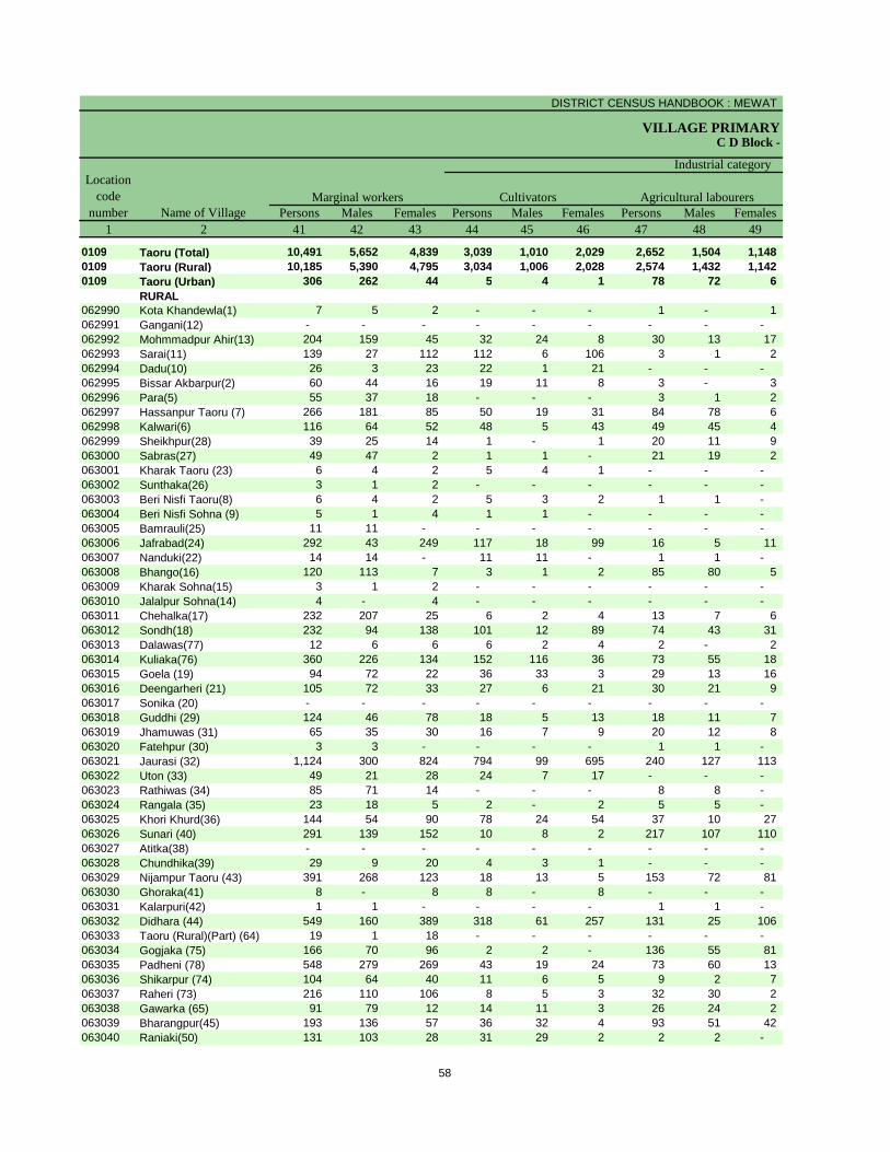
DISTRICT CENSUS HANDBOOK : MEWAT
VILLAGE PRIMARYC D Block -
Persons Males Females Persons Males Females Persons Males Females1 2 41 42 43 44 45 46 47 48 49
0109 Taoru (Total) 10,491 5,652 4,839 3,039 1,010 2,029 2,652 1,504 1,148 0109 Taoru (Rural) 10,185 5,390 4,795 3,034 1,006 2,028 2,574 1,432 1,142 0109 Taoru (Urban) 306 262 44 5 4 1 78 72 6
RURAL062990 Kota Khandewla(1) 7 5 2 - - - 1 - 1 062991 Gangani(12) - - - - - - - - - 062992 Mohmmadpur Ahir(13) 204 159 45 32 24 8 30 13 17 062993 Sarai(11) 139 27 112 112 6 106 3 1 2 062994 Dadu(10) 26 3 23 22 1 21 - - - 062995 Bissar Akbarpur(2) 60 44 16 19 11 8 3 - 3 062996 Para(5) 55 37 18 - - - 3 1 2 062997 Hassanpur Taoru (7) 266 181 85 50 19 31 84 78 6 062998 Kalwari(6) 116 64 52 48 5 43 49 45 4 062999 Sheikhpur(28) 39 25 14 1 - 1 20 11 9 063000 Sabras(27) 49 47 2 1 1 - 21 19 2 063001 Kharak Taoru (23) 6 4 2 5 4 1 - - - 063002 Sunthaka(26) 3 1 2 - - - - - - 063003 Beri Nisfi Taoru(8) 6 4 2 5 3 2 1 1 - 063004 Beri Nisfi Sohna (9) 5 1 4 1 1 - - - - 063005 Bamrauli(25) 11 11 - - - - - - - 063006 Jafrabad(24) 292 43 249 117 18 99 16 5 11 063007 Nanduki(22) 14 14 - 11 11 - 1 1 - 063008 Bhango(16) 120 113 7 3 1 2 85 80 5 063009 Kharak Sohna(15) 3 1 2 - - - - - - 063010 Jalalpur Sohna(14) 4 - 4 - - - - - - 063011 Chehalka(17) 232 207 25 6 2 4 13 7 6 063012 Sondh(18) 232 94 138 101 12 89 74 43 31 063013 Dalawas(77) 12 6 6 6 2 4 2 - 2 063014 Kuliaka(76) 360 226 134 152 116 36 73 55 18 063015 Goela (19) 94 72 22 36 33 3 29 13 16 063016 Deengarheri (21) 105 72 33 27 6 21 30 21 9 063017 Sonika (20) - - - - - - - - - 063018 Guddhi (29) 124 46 78 18 5 13 18 11 7 063019 Jhamuwas (31) 65 35 30 16 7 9 20 12 8 063020 Fatehpur (30) 3 3 - - - - 1 1 - 063021 Jaurasi (32) 1,124 300 824 794 99 695 240 127 113 063022 Uton (33) 49 21 28 24 7 17 - - - 063023 Rathiwas (34) 85 71 14 - - - 8 8 - 063024 Rangala (35) 23 18 5 2 - 2 5 5 - 063025 Khori Khurd(36) 144 54 90 78 24 54 37 10 27 063026 Sunari (40) 291 139 152 10 8 2 217 107 110 063027 Atitka(38) - - - - - - - - - 063028 Chundhika(39) 29 9 20 4 3 1 - - - 063029 Nijampur Taoru (43) 391 268 123 18 13 5 153 72 81 063030 Ghoraka(41) 8 - 8 8 - 8 - - - 063031 Kalarpuri(42) 1 1 - - - - 1 1 - 063032 Didhara (44) 549 160 389 318 61 257 131 25 106 063033 Taoru (Rural)(Part) (64) 19 1 18 - - - - - - 063034 Gogjaka (75) 166 70 96 2 2 - 136 55 81 063035 Padheni (78) 548 279 269 43 19 24 73 60 13 063036 Shikarpur (74) 104 64 40 11 6 5 9 2 7 063037 Raheri (73) 216 110 106 8 5 3 32 30 2 063038 Gawarka (65) 91 79 12 14 11 3 26 24 2 063039 Bharangpur(45) 193 136 57 36 32 4 93 51 42 063040 Raniaki(50) 131 103 28 31 29 2 2 2 -
Name of VillageMarginal workers Cultivators Agricultural labourers
Industrial category Location
code number
58
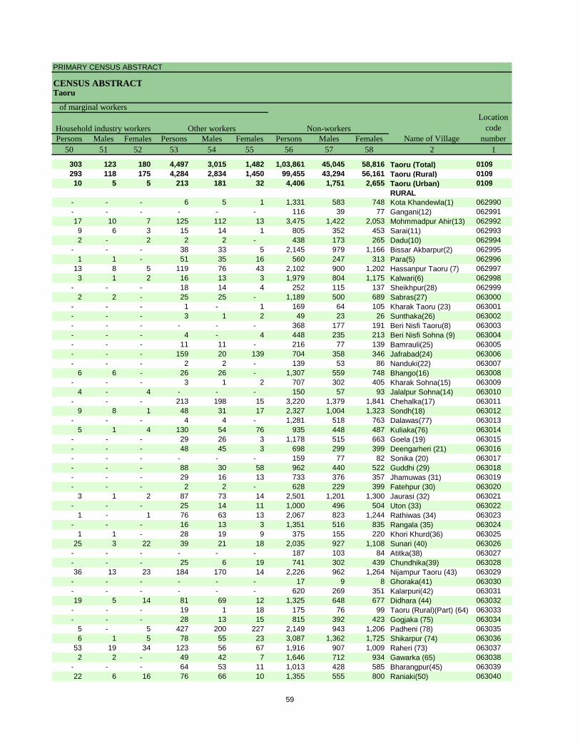
PRIMARY CENSUS ABSTRACT
CENSUS ABSTRACTTaoru
Persons Males Females Persons Males Females Persons Males Females50 51 52 53 54 55 56 57 58 2 1
303 123 180 4,497 3,015 1,482 1,03,861 45,045 58,816 Taoru (Total) 0109293 118 175 4,284 2,834 1,450 99,455 43,294 56,161 Taoru (Rural) 010910 5 5 213 181 32 4,406 1,751 2,655 Taoru (Urban) 0109
RURAL- - - 6 5 1 1,331 583 748 Kota Khandewla(1) 062990- - - - - - 116 39 77 Gangani(12) 06299117 10 7 125 112 13 3,475 1,422 2,053 Mohmmadpur Ahir(13) 0629929 6 3 15 14 1 805 352 453 Sarai(11) 0629932 - 2 2 2 - 438 173 265 Dadu(10) 062994
- - - 38 33 5 2,145 979 1,166 Bissar Akbarpur(2) 0629951 1 - 51 35 16 560 247 313 Para(5) 062996
13 8 5 119 76 43 2,102 900 1,202 Hassanpur Taoru (7) 0629973 1 2 16 13 3 1,979 804 1,175 Kalwari(6) 062998
- - - 18 14 4 252 115 137 Sheikhpur(28) 0629992 2 - 25 25 - 1,189 500 689 Sabras(27) 063000
- - - 1 - 1 169 64 105 Kharak Taoru (23) 063001- - - 3 1 2 49 23 26 Sunthaka(26) 063002- - - - - - 368 177 191 Beri Nisfi Taoru(8) 063003- - - 4 - 4 448 235 213 Beri Nisfi Sohna (9) 063004- - - 11 11 - 216 77 139 Bamrauli(25) 063005- - - 159 20 139 704 358 346 Jafrabad(24) 063006- - - 2 2 - 139 53 86 Nanduki(22) 063007
6 6 - 26 26 - 1,307 559 748 Bhango(16) 063008- - - 3 1 2 707 302 405 Kharak Sohna(15) 063009
4 - 4 - - - 150 57 93 Jalalpur Sohna(14) 063010- - - 213 198 15 3,220 1,379 1,841 Chehalka(17) 063011
9 8 1 48 31 17 2,327 1,004 1,323 Sondh(18) 063012- - - 4 4 - 1,281 518 763 Dalawas(77) 063013
5 1 4 130 54 76 935 448 487 Kuliaka(76) 063014- - - 29 26 3 1,178 515 663 Goela (19) 063015- - - 48 45 3 698 299 399 Deengarheri (21) 063016- - - - - - 159 77 82 Sonika (20) 063017- - - 88 30 58 962 440 522 Guddhi (29) 063018- - - 29 16 13 733 376 357 Jhamuwas (31) 063019- - - 2 2 - 628 229 399 Fatehpur (30) 063020
3 1 2 87 73 14 2,501 1,201 1,300 Jaurasi (32) 063021- - - 25 14 11 1,000 496 504 Uton (33) 063022
1 - 1 76 63 13 2,067 823 1,244 Rathiwas (34) 063023- - - 16 13 3 1,351 516 835 Rangala (35) 063024
1 1 - 28 19 9 375 155 220 Khori Khurd(36) 06302525 3 22 39 21 18 2,035 927 1,108 Sunari (40) 063026
- - - - - - 187 103 84 Atitka(38) 063027- - - 25 6 19 741 302 439 Chundhika(39) 06302836 13 23 184 170 14 2,226 962 1,264 Nijampur Taoru (43) 063029
- - - - - - 17 9 8 Ghoraka(41) 063030- - - - - - 620 269 351 Kalarpuri(42) 06303119 5 14 81 69 12 1,325 648 677 Didhara (44) 063032
- - - 19 1 18 175 76 99 Taoru (Rural)(Part) (64) 063033- - - 28 13 15 815 392 423 Gogjaka (75) 063034
5 - 5 427 200 227 2,149 943 1,206 Padheni (78) 0630356 1 5 78 55 23 3,087 1,362 1,725 Shikarpur (74) 063036
53 19 34 123 56 67 1,916 907 1,009 Raheri (73) 0630372 2 - 49 42 7 1,646 712 934 Gawarka (65) 063038
- - - 64 53 11 1,013 428 585 Bharangpur(45) 06303922 6 16 76 66 10 1,355 555 800 Raniaki(50) 063040
Location code
numberHousehold industry workers
Name of VillageOther workers Non-workers
of marginal workers
59
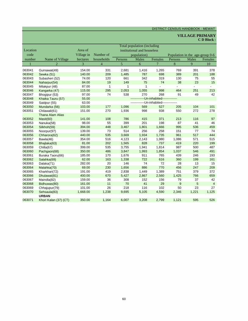
DISTRICT CENSUS HANDBOOK : MEWAT
VILLAGE PRIMARY
Persons Males Females Persons Males Females1 2 3 4 5 6 7 8 9 10
Name of Village
Location code
number
Total population (including institutional and houseless
population)Area of
Village in hectares
Number of households
C D Block -
Population in the age-group 0-6
063041 Gurnawat(49) 154.00 331 2,681 1,416 1,265 769 391 378 063042 Sewka (51) 140.00 209 1,485 787 698 389 201 188 063043 Subasheri (52) 74.00 120 661 342 319 130 75 55 063044 Naharpur(54) 84.00 19 149 75 74 38 23 15 063045 Milakpur (48) 87.00 1 1 1 - - - - 063046 Kangarka (47) 115.00 295 2,053 1,055 998 464 251 213 063047 Bhogipur (53) 97.00 74 538 270 268 91 49 42 063048 Khaika Tauru (57) 55.00063049 Saidpur (55) 63.00063050 Mundarka (56) 103.00 177 1,096 569 527 205 104 101 063051 Chilawali(61) 151.00 270 1,936 998 938 550 272 278
063052Thana Alam Alias Masit(60) 141.00 108 786 415 371 213 116 97
063053 Nanuka(58) 98.00 55 399 201 198 87 41 46 063054 Silkhoh(59) 394.00 448 3,467 1,801 1,666 995 536 459 063055 Noorpur(97) 139.00 73 514 256 258 151 77 74 063056 Chharora(62) 440.00 535 3,669 1,934 1,735 961 517 444 063057 Bawla(46) 354.00 516 4,123 2,143 1,980 1,086 571 515 063058 Bhajlaka(63) 81.00 202 1,565 828 737 419 220 199 063059 Chilla(67) 399.00 535 3,755 1,941 1,814 987 500 487 063060 Pachgaon(68) 350.00 486 3,847 1,993 1,854 1,037 546 491 063061 Buraka Taoru(66) 185.00 170 1,676 911 765 439 246 193 063062 Salahka(69) 62.00 163 1,338 722 616 360 199 161 063063 Dalaka(71) 282.00 20 146 74 72 28 13 15 063064 Malahka(70) 69.00 230 1,656 886 770 456 247 209 063065 Kharkhari(72) 191.00 419 2,838 1,449 1,389 751 379 372 063066 Dhulawat(81) 400.00 670 5,427 2,867 2,560 1,425 766 659 063067 Maindla(82) 159.00 36 308 152 156 79 37 42 063068 Bidhuwas(80) 161.00 11 70 41 29 9 5 4 063069 Chhajupur(79) 101.00 26 218 116 102 50 23 27 063070 Sehsaula(83) 1,668.00 1,238 9,695 5,105 4,590 2,346 1,221 1,125
URBAN063071 Khori Kalan (37) (CT) 350.00 1,164 6,007 3,208 2,799 1,121 595 526
-------------Un-inhabited---------------------------Un-inhabited--------------
60
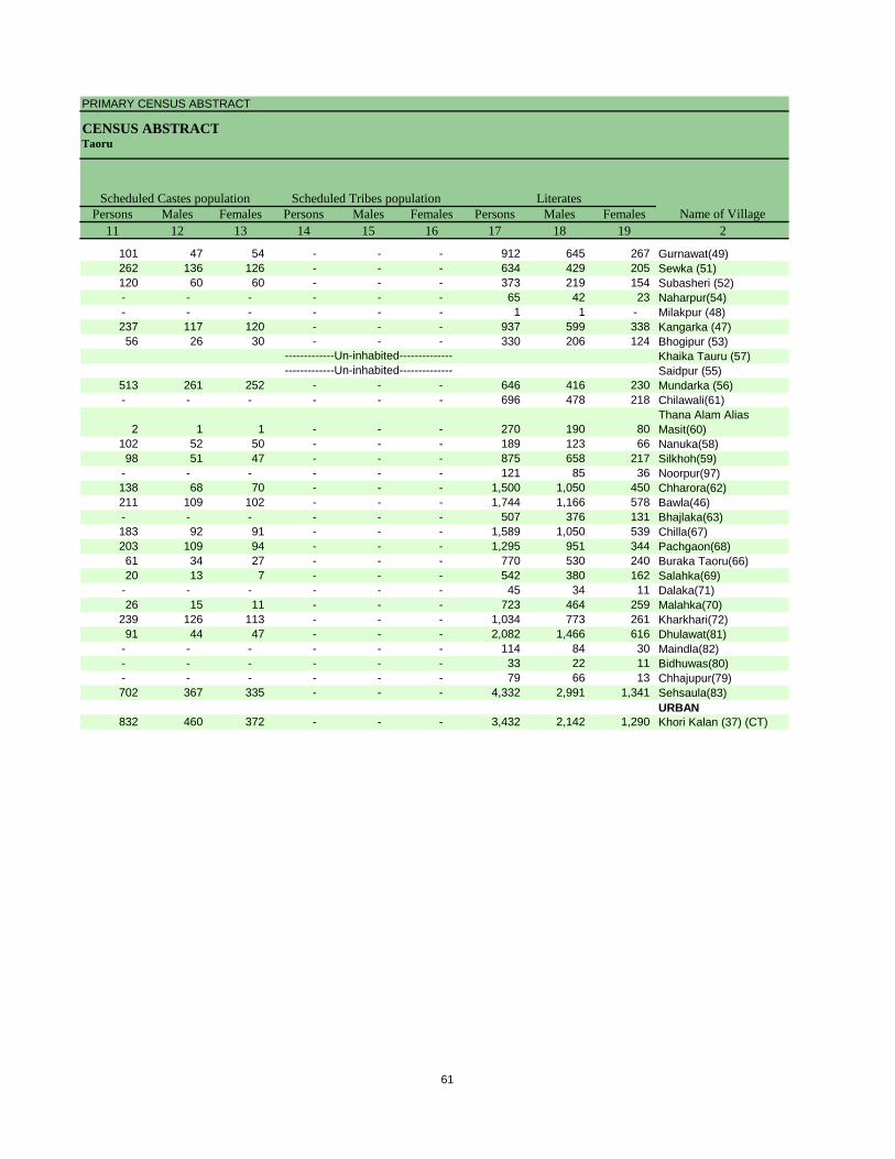
PRIMARY CENSUS ABSTRACT
CENSUS ABSTRACTTaoru
Persons Males Females Persons Males Females Persons Males Females11 12 13 14 15 16 17 18 19 2
Name of VillageLiteratesScheduled Castes population Scheduled Tribes population
101 47 54 - - - 912 645 267 Gurnawat(49)262 136 126 - - - 634 429 205 Sewka (51)120 60 60 - - - 373 219 154 Subasheri (52)- - - - - - 65 42 23 Naharpur(54)- - - - - - 1 1 - Milakpur (48)237 117 120 - - - 937 599 338 Kangarka (47)56 26 30 - - - 330 206 124 Bhogipur (53)
Khaika Tauru (57)Saidpur (55)
513 261 252 - - - 646 416 230 Mundarka (56)- - - - - - 696 478 218 Chilawali(61)
2 1 1 - - - 270 190 80 Thana Alam Alias Masit(60)
102 52 50 - - - 189 123 66 Nanuka(58)98 51 47 - - - 875 658 217 Silkhoh(59)
- - - - - - 121 85 36 Noorpur(97)138 68 70 - - - 1,500 1,050 450 Chharora(62)211 109 102 - - - 1,744 1,166 578 Bawla(46)- - - - - - 507 376 131 Bhajlaka(63)183 92 91 - - - 1,589 1,050 539 Chilla(67)203 109 94 - - - 1,295 951 344 Pachgaon(68)61 34 27 - - - 770 530 240 Buraka Taoru(66)20 13 7 - - - 542 380 162 Salahka(69)
- - - - - - 45 34 11 Dalaka(71)26 15 11 - - - 723 464 259 Malahka(70)
239 126 113 - - - 1,034 773 261 Kharkhari(72)91 44 47 - - - 2,082 1,466 616 Dhulawat(81)
- - - - - - 114 84 30 Maindla(82)- - - - - - 33 22 11 Bidhuwas(80)- - - - - - 79 66 13 Chhajupur(79)702 367 335 - - - 4,332 2,991 1,341 Sehsaula(83)
URBAN832 460 372 - - - 3,432 2,142 1,290 Khori Kalan (37) (CT)
-------------Un-inhabited---------------------------Un-inhabited--------------
61
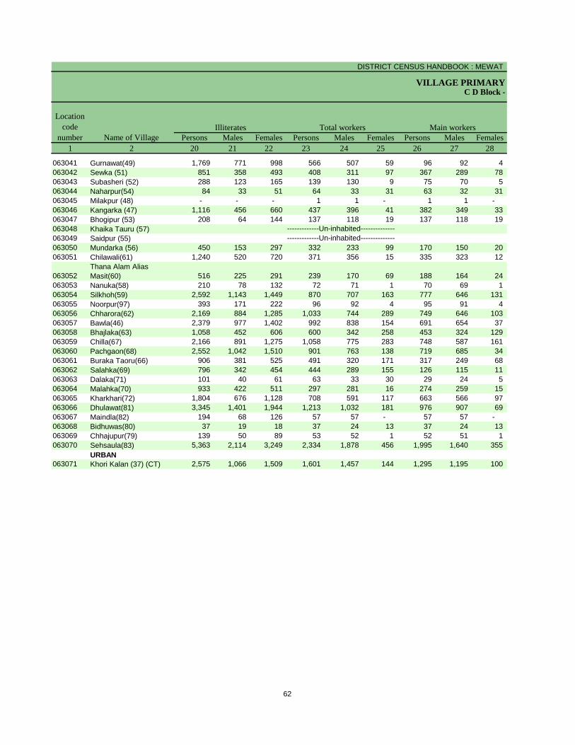
DISTRICT CENSUS HANDBOOK : MEWAT
VILLAGE PRIMARYC D Block -
Persons Males Females Persons Males Females Persons Males Females1 2 20 21 22 23 24 25 26 27 28
Name of Village
Location code
numberIlliterates Total workers Main workers
063041 Gurnawat(49) 1,769 771 998 566 507 59 96 92 4 063042 Sewka (51) 851 358 493 408 311 97 367 289 78 063043 Subasheri (52) 288 123 165 139 130 9 75 70 5 063044 Naharpur(54) 84 33 51 64 33 31 63 32 31 063045 Milakpur (48) - - - 1 1 - 1 1 - 063046 Kangarka (47) 1,116 456 660 437 396 41 382 349 33 063047 Bhogipur (53) 208 64 144 137 118 19 137 118 19 063048 Khaika Tauru (57)063049 Saidpur (55)063050 Mundarka (56) 450 153 297 332 233 99 170 150 20 063051 Chilawali(61) 1,240 520 720 371 356 15 335 323 12
063052Thana Alam Alias Masit(60) 516 225 291 239 170 69 188 164 24
063053 Nanuka(58) 210 78 132 72 71 1 70 69 1 063054 Silkhoh(59) 2,592 1,143 1,449 870 707 163 777 646 131 063055 Noorpur(97) 393 171 222 96 92 4 95 91 4 063056 Chharora(62) 2,169 884 1,285 1,033 744 289 749 646 103 063057 Bawla(46) 2,379 977 1,402 992 838 154 691 654 37 063058 Bhajlaka(63) 1,058 452 606 600 342 258 453 324 129 063059 Chilla(67) 2,166 891 1,275 1,058 775 283 748 587 161 063060 Pachgaon(68) 2,552 1,042 1,510 901 763 138 719 685 34 063061 Buraka Taoru(66) 906 381 525 491 320 171 317 249 68 063062 Salahka(69) 796 342 454 444 289 155 126 115 11 063063 Dalaka(71) 101 40 61 63 33 30 29 24 5 063064 Malahka(70) 933 422 511 297 281 16 274 259 15 063065 Kharkhari(72) 1,804 676 1,128 708 591 117 663 566 97 063066 Dhulawat(81) 3,345 1,401 1,944 1,213 1,032 181 976 907 69 063067 Maindla(82) 194 68 126 57 57 - 57 57 - 063068 Bidhuwas(80) 37 19 18 37 24 13 37 24 13 063069 Chhajupur(79) 139 50 89 53 52 1 52 51 1 063070 Sehsaula(83) 5,363 2,114 3,249 2,334 1,878 456 1,995 1,640 355
URBAN063071 Khori Kalan (37) (CT) 2,575 1,066 1,509 1,601 1,457 144 1,295 1,195 100
-------------Un-inhabited---------------------------Un-inhabited--------------
62
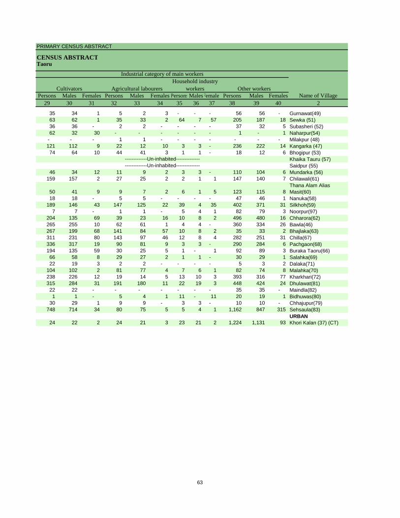
PRIMARY CENSUS ABSTRACT
CENSUS ABSTRACTTaoru
Persons Males Females Persons Males Females PersonsMalesFemales Persons Males Females29 30 31 32 33 34 35 36 37 38 39 40 2
CultivatorsName of Village
Household industry workersAgricultural labourers
Industrial category of main workers
Other workers
35 34 1 5 2 3 - - - 56 56 - Gurnawat(49)63 62 1 35 33 2 64 7 57 205 187 18 Sewka (51)36 36 - 2 2 - - - - 37 32 5 Subasheri (52)62 32 30 - - - - - - 1 - 1 Naharpur(54)
- - - 1 1 - - - - - - - Milakpur (48)121 112 9 22 12 10 3 3 - 236 222 14 Kangarka (47)74 64 10 44 41 3 1 1 - 18 12 6 Bhogipur (53)
Khaika Tauru (57)Saidpur (55)
46 34 12 11 9 2 3 3 - 110 104 6 Mundarka (56)159 157 2 27 25 2 2 1 1 147 140 7 Chilawali(61)
50 41 9 9 7 2 6 1 5 123 115 8 Thana Alam Alias Masit(60)
18 18 - 5 5 - - - - 47 46 1 Nanuka(58)189 146 43 147 125 22 39 4 35 402 371 31 Silkhoh(59)
7 7 - 1 1 - 5 4 1 82 79 3 Noorpur(97)204 135 69 39 23 16 10 8 2 496 480 16 Chharora(62)265 255 10 62 61 1 4 4 - 360 334 26 Bawla(46)267 199 68 141 84 57 10 8 2 35 33 2 Bhajlaka(63)311 231 80 143 97 46 12 8 4 282 251 31 Chilla(67)336 317 19 90 81 9 3 3 - 290 284 6 Pachgaon(68)194 135 59 30 25 5 1 - 1 92 89 3 Buraka Taoru(66)66 58 8 29 27 2 1 1 - 30 29 1 Salahka(69)22 19 3 2 2 - - - - 5 3 2 Dalaka(71)
104 102 2 81 77 4 7 6 1 82 74 8 Malahka(70)238 226 12 19 14 5 13 10 3 393 316 77 Kharkhari(72)315 284 31 191 180 11 22 19 3 448 424 24 Dhulawat(81)22 22 - - - - - - - 35 35 - Maindla(82)1 1 - 5 4 1 11 - 11 20 19 1 Bidhuwas(80)
30 29 1 9 9 - 3 3 - 10 10 - Chhajupur(79)748 714 34 80 75 5 5 4 1 1,162 847 315 Sehsaula(83)
URBAN24 22 2 24 21 3 23 21 2 1,224 1,131 93 Khori Kalan (37) (CT)
-------------Un-inhabited---------------------------Un-inhabited--------------
63
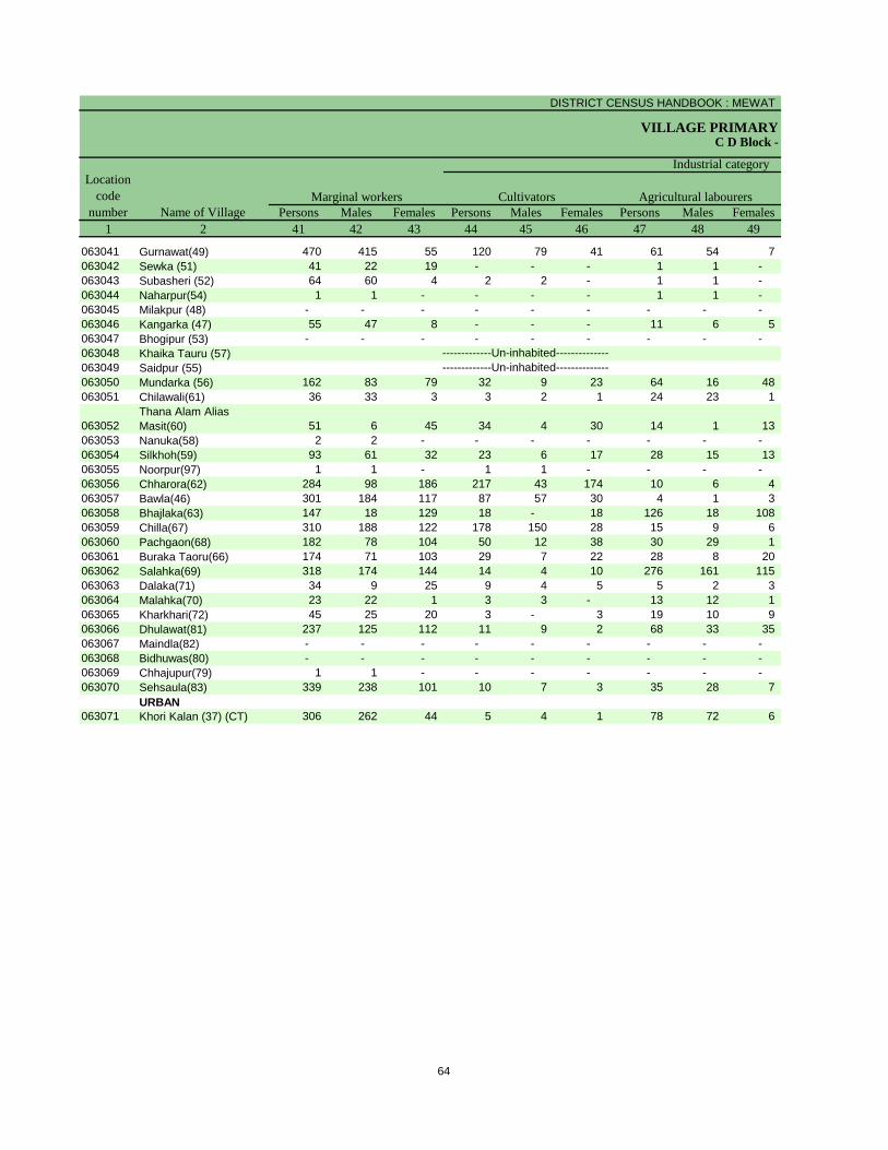
DISTRICT CENSUS HANDBOOK : MEWAT
VILLAGE PRIMARYC D Block -
Persons Males Females Persons Males Females Persons Males Females1 2 41 42 43 44 45 46 47 48 49
Name of VillageMarginal workers Cultivators Agricultural labourers
Industrial category Location
code number
063041 Gurnawat(49) 470 415 55 120 79 41 61 54 7 063042 Sewka (51) 41 22 19 - - - 1 1 - 063043 Subasheri (52) 64 60 4 2 2 - 1 1 - 063044 Naharpur(54) 1 1 - - - - 1 1 - 063045 Milakpur (48) - - - - - - - - - 063046 Kangarka (47) 55 47 8 - - - 11 6 5 063047 Bhogipur (53) - - - - - - - - - 063048 Khaika Tauru (57)063049 Saidpur (55)063050 Mundarka (56) 162 83 79 32 9 23 64 16 48 063051 Chilawali(61) 36 33 3 3 2 1 24 23 1
063052Thana Alam Alias Masit(60) 51 6 45 34 4 30 14 1 13
063053 Nanuka(58) 2 2 - - - - - - - 063054 Silkhoh(59) 93 61 32 23 6 17 28 15 13 063055 Noorpur(97) 1 1 - 1 1 - - - - 063056 Chharora(62) 284 98 186 217 43 174 10 6 4 063057 Bawla(46) 301 184 117 87 57 30 4 1 3 063058 Bhajlaka(63) 147 18 129 18 - 18 126 18 108 063059 Chilla(67) 310 188 122 178 150 28 15 9 6 063060 Pachgaon(68) 182 78 104 50 12 38 30 29 1 063061 Buraka Taoru(66) 174 71 103 29 7 22 28 8 20 063062 Salahka(69) 318 174 144 14 4 10 276 161 115 063063 Dalaka(71) 34 9 25 9 4 5 5 2 3 063064 Malahka(70) 23 22 1 3 3 - 13 12 1 063065 Kharkhari(72) 45 25 20 3 - 3 19 10 9 063066 Dhulawat(81) 237 125 112 11 9 2 68 33 35 063067 Maindla(82) - - - - - - - - - 063068 Bidhuwas(80) - - - - - - - - - 063069 Chhajupur(79) 1 1 - - - - - - - 063070 Sehsaula(83) 339 238 101 10 7 3 35 28 7
URBAN063071 Khori Kalan (37) (CT) 306 262 44 5 4 1 78 72 6
-------------Un-inhabited---------------------------Un-inhabited--------------
64
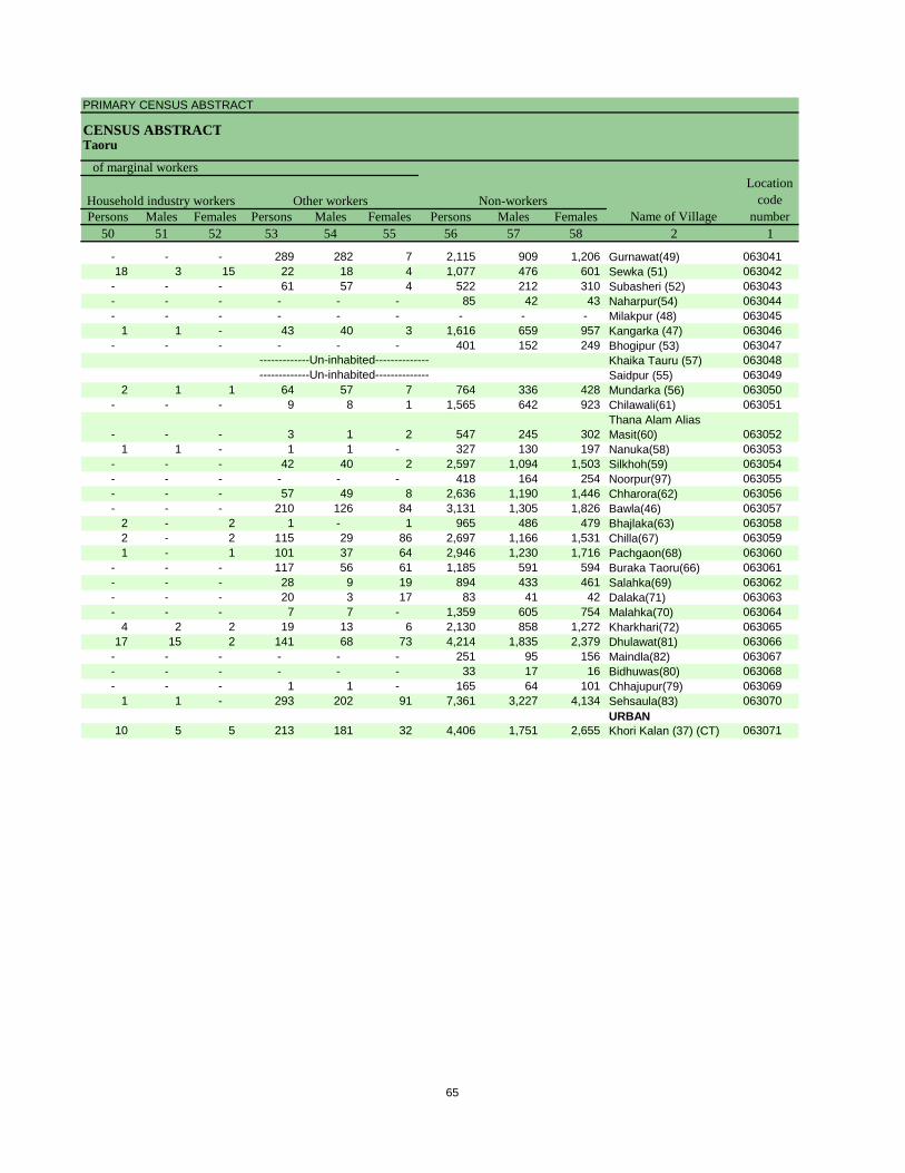
PRIMARY CENSUS ABSTRACT
CENSUS ABSTRACTTaoru
Persons Males Females Persons Males Females Persons Males Females50 51 52 53 54 55 56 57 58 2 1
Location code
numberHousehold industry workers
Name of VillageOther workers Non-workers
of marginal workers
- - - 289 282 7 2,115 909 1,206 Gurnawat(49) 06304118 3 15 22 18 4 1,077 476 601 Sewka (51) 063042
- - - 61 57 4 522 212 310 Subasheri (52) 063043- - - - - - 85 42 43 Naharpur(54) 063044- - - - - - - - - Milakpur (48) 063045
1 1 - 43 40 3 1,616 659 957 Kangarka (47) 063046- - - - - - 401 152 249 Bhogipur (53) 063047
Khaika Tauru (57) 063048Saidpur (55) 063049
2 1 1 64 57 7 764 336 428 Mundarka (56) 063050- - - 9 8 1 1,565 642 923 Chilawali(61) 063051
- - - 3 1 2 547 245 302 Thana Alam Alias Masit(60) 063052
1 1 - 1 1 - 327 130 197 Nanuka(58) 063053- - - 42 40 2 2,597 1,094 1,503 Silkhoh(59) 063054- - - - - - 418 164 254 Noorpur(97) 063055- - - 57 49 8 2,636 1,190 1,446 Chharora(62) 063056- - - 210 126 84 3,131 1,305 1,826 Bawla(46) 063057
2 - 2 1 - 1 965 486 479 Bhajlaka(63) 0630582 - 2 115 29 86 2,697 1,166 1,531 Chilla(67) 0630591 - 1 101 37 64 2,946 1,230 1,716 Pachgaon(68) 063060
- - - 117 56 61 1,185 591 594 Buraka Taoru(66) 063061- - - 28 9 19 894 433 461 Salahka(69) 063062- - - 20 3 17 83 41 42 Dalaka(71) 063063- - - 7 7 - 1,359 605 754 Malahka(70) 063064
4 2 2 19 13 6 2,130 858 1,272 Kharkhari(72) 06306517 15 2 141 68 73 4,214 1,835 2,379 Dhulawat(81) 063066
- - - - - - 251 95 156 Maindla(82) 063067- - - - - - 33 17 16 Bidhuwas(80) 063068- - - 1 1 - 165 64 101 Chhajupur(79) 063069
1 1 - 293 202 91 7,361 3,227 4,134 Sehsaula(83) 063070URBAN
10 5 5 213 181 32 4,406 1,751 2,655 Khori Kalan (37) (CT) 063071
-------------Un-inhabited---------------------------Un-inhabited--------------
65
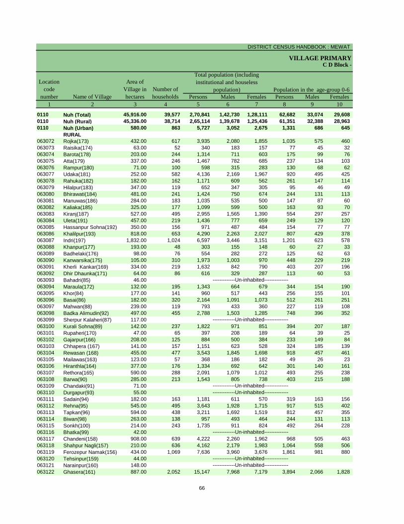
DISTRICT CENSUS HANDBOOK : MEWAT
VILLAGE PRIMARY
Persons Males Females Persons Males Females1 2 3 4 5 6 7 8 9 10
0110 Nuh (Total) 45,916.00 39,577 2,70,841 1,42,730 1,28,111 62,682 33,074 29,608 0110 Nuh (Rural) 45,336.00 38,714 2,65,114 1,39,678 1,25,436 61,351 32,388 28,963 0110 Nuh (Urban) 580.00 863 5,727 3,052 2,675 1,331 686 645
RURAL063072 Rojka(173) 432.00 617 3,935 2,080 1,855 1,035 575 460 063073 Raisika(174) 63.00 52 340 183 157 77 45 32 063074 Barota(178) 203.00 244 1,314 711 603 175 99 76 063075 Atta(179) 337.00 246 1,467 782 685 237 134 103 063076 Rampur(180) 71.00 100 598 315 283 130 68 62 063077 Udaka(181) 252.00 582 4,136 2,169 1,967 920 495 425 063078 Rahuka(182) 182.00 162 1,171 609 562 261 147 114 063079 Hilalpur(183) 347.00 119 652 347 305 95 46 49 063080 Bhirawati(184) 481.00 241 1,424 750 674 244 131 113 063081 Manuwas(186) 284.00 183 1,035 535 500 147 87 60 063082 Kaliaka(185) 325.00 177 1,099 599 500 163 93 70 063083 Kiranj(187) 527.00 495 2,955 1,565 1,390 554 297 257 063084 Uleta(191) 457.00 219 1,436 777 659 249 129 120 063085 Hassanpur Sohna(192) 350.00 156 971 487 484 154 77 77 063086 Khalilpur(193) 818.00 653 4,290 2,263 2,027 807 429 378 063087 Indri(197) 1,832.00 1,024 6,597 3,446 3,151 1,201 623 578 063088 Khanpur(177) 193.00 48 303 155 148 60 27 33 063089 Badhelaki(176) 98.00 76 554 282 272 125 62 63 063090 Kanwarsika(175) 105.00 310 1,973 1,003 970 448 229 219 063091 Kherli Kankar(169) 334.00 219 1,632 842 790 403 207 196 063092 Dhir Dhaunka(171) 64.00 86 616 329 287 113 60 53 063093 Bahadri(85) 46.00063094 Maraula(172) 132.00 195 1,343 664 679 344 154 190 063095 Khor(84) 177.00 141 960 517 443 256 155 101 063096 Basai(86) 182.00 320 2,164 1,091 1,073 512 261 251 063097 Mahwan(88) 239.00 119 793 433 360 227 119 108 063098 Badka Alimudin(92) 497.00 455 2,788 1,503 1,285 748 396 352 063099 Sherpur Kalaheri(87) 117.00063100 Kurali Sohna(89) 142.00 237 1,822 971 851 394 207 187 063101 Rupaheri(170) 47.00 65 397 208 189 64 39 25 063102 Gajarpur(166) 208.00 125 884 500 384 233 149 84 063103 Chhapera (167) 141.00 157 1,151 623 528 324 185 139 063104 Rewasan (168) 455.00 477 3,543 1,845 1,698 918 457 461 063105 Mailawas(163) 123.00 57 368 186 182 49 26 23 063106 Hiranthla(164) 377.00 176 1,334 692 642 301 140 161 063107 Rethora(165) 590.00 288 2,091 1,079 1,012 493 255 238 063108 Barwa(90) 285.00 213 1,543 805 738 403 215 188 063109 Chandaki(91) 71.00063110 Durgapur(93) 55.00063111 Sadain(94) 182.00 163 1,181 611 570 319 163 156 063112 Rehna(95) 545.00 495 3,643 1,928 1,715 917 515 402 063113 Tapkan(96) 594.00 438 3,211 1,692 1,519 812 457 355 063114 Biwan(98) 263.00 138 957 493 464 244 131 113 063115 Sonkh(100) 214.00 243 1,735 911 824 492 264 228 063116 Bhatka(99) 42.00063117 Chandeni(158) 908.00 639 4,222 2,260 1,962 968 505 463 063118 Shahpur Nagli(157) 210.00 636 4,162 2,179 1,983 1,064 558 506 063119 Ferozepur Namak(156) 434.00 1,069 7,636 3,960 3,676 1,861 981 880 063120 Tehsinpur(159) 44.00063121 Narainpur(160) 148.00063122 Ghasera(161) 887.00 2,052 15,147 7,968 7,179 3,894 2,066 1,828
-------------Un-inhabited--------------
-------------Un-inhabited--------------
-------------Un-inhabited--------------
-------------Un-inhabited---------------------------Un-inhabited--------------
-------------Un-inhabited--------------
-------------Un-inhabited--------------
C D Block -
Population in the age-group 0-6Name of Village
Location code
number
Total population (including institutional and houseless
population)Area of
Village in hectares
Number of households
66
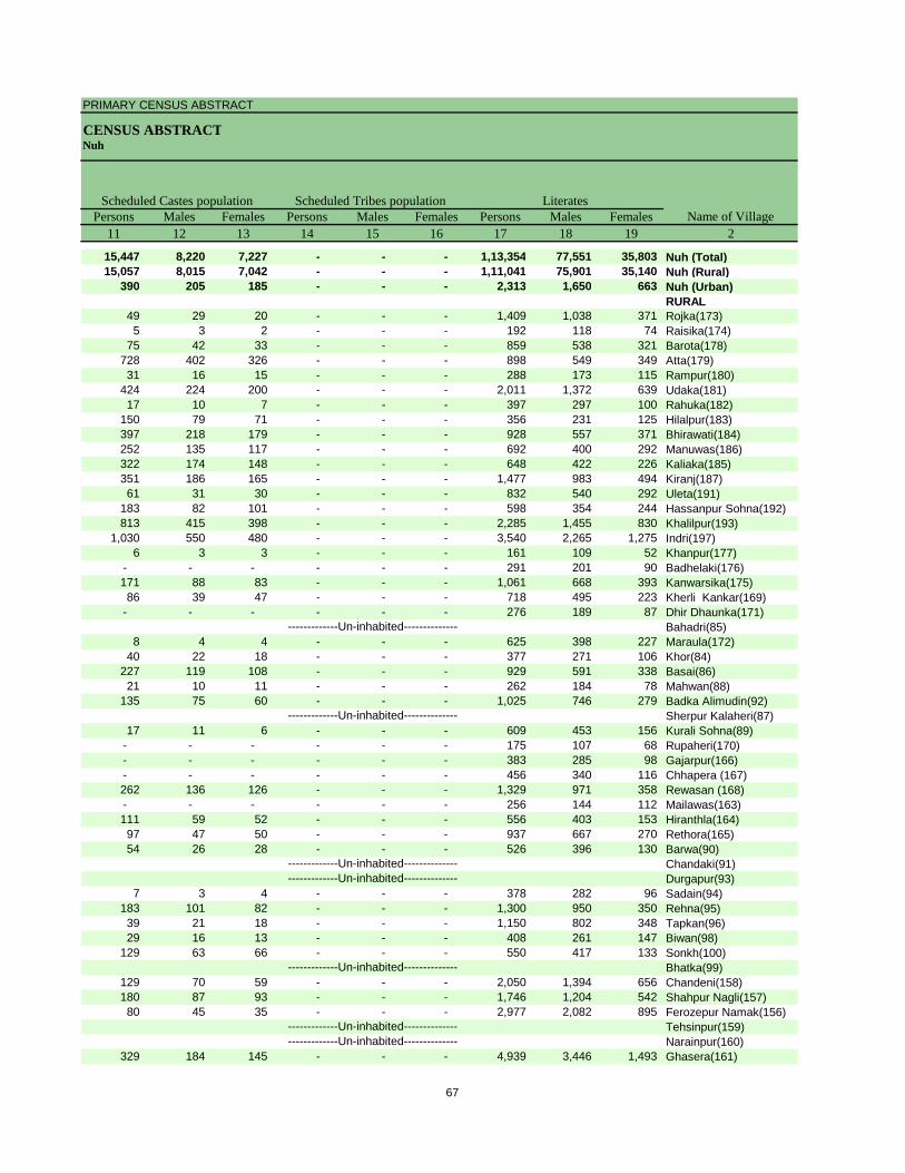
PRIMARY CENSUS ABSTRACT
CENSUS ABSTRACTNuh
Persons Males Females Persons Males Females Persons Males Females11 12 13 14 15 16 17 18 19 2
15,447 8,220 7,227 - - - 1,13,354 77,551 35,803 Nuh (Total)15,057 8,015 7,042 - - - 1,11,041 75,901 35,140 Nuh (Rural)
390 205 185 - - - 2,313 1,650 663 Nuh (Urban)RURAL
49 29 20 - - - 1,409 1,038 371 Rojka(173)5 3 2 - - - 192 118 74 Raisika(174)
75 42 33 - - - 859 538 321 Barota(178)728 402 326 - - - 898 549 349 Atta(179)31 16 15 - - - 288 173 115 Rampur(180)
424 224 200 - - - 2,011 1,372 639 Udaka(181)17 10 7 - - - 397 297 100 Rahuka(182)
150 79 71 - - - 356 231 125 Hilalpur(183)397 218 179 - - - 928 557 371 Bhirawati(184)252 135 117 - - - 692 400 292 Manuwas(186)322 174 148 - - - 648 422 226 Kaliaka(185)351 186 165 - - - 1,477 983 494 Kiranj(187)61 31 30 - - - 832 540 292 Uleta(191)
183 82 101 - - - 598 354 244 Hassanpur Sohna(192)813 415 398 - - - 2,285 1,455 830 Khalilpur(193)
1,030 550 480 - - - 3,540 2,265 1,275 Indri(197)6 3 3 - - - 161 109 52 Khanpur(177)
- - - - - - 291 201 90 Badhelaki(176)171 88 83 - - - 1,061 668 393 Kanwarsika(175)86 39 47 - - - 718 495 223 Kherli Kankar(169)
- - - - - - 276 189 87 Dhir Dhaunka(171)Bahadri(85)
8 4 4 - - - 625 398 227 Maraula(172)40 22 18 - - - 377 271 106 Khor(84)
227 119 108 - - - 929 591 338 Basai(86)21 10 11 - - - 262 184 78 Mahwan(88)
135 75 60 - - - 1,025 746 279 Badka Alimudin(92)Sherpur Kalaheri(87)
17 11 6 - - - 609 453 156 Kurali Sohna(89)- - - - - - 175 107 68 Rupaheri(170)- - - - - - 383 285 98 Gajarpur(166)- - - - - - 456 340 116 Chhapera (167)262 136 126 - - - 1,329 971 358 Rewasan (168)- - - - - - 256 144 112 Mailawas(163)111 59 52 - - - 556 403 153 Hiranthla(164)97 47 50 - - - 937 667 270 Rethora(165)54 26 28 - - - 526 396 130 Barwa(90)
Chandaki(91)Durgapur(93)
7 3 4 - - - 378 282 96 Sadain(94)183 101 82 - - - 1,300 950 350 Rehna(95)39 21 18 - - - 1,150 802 348 Tapkan(96)29 16 13 - - - 408 261 147 Biwan(98)
129 63 66 - - - 550 417 133 Sonkh(100)Bhatka(99)
129 70 59 - - - 2,050 1,394 656 Chandeni(158)180 87 93 - - - 1,746 1,204 542 Shahpur Nagli(157)80 45 35 - - - 2,977 2,082 895 Ferozepur Namak(156)
Tehsinpur(159)Narainpur(160)
329 184 145 - - - 4,939 3,446 1,493 Ghasera(161)-------------Un-inhabited--------------
-------------Un-inhabited--------------
-------------Un-inhabited--------------
-------------Un-inhabited---------------------------Un-inhabited--------------
-------------Un-inhabited--------------
-------------Un-inhabited--------------
Scheduled Castes population Scheduled Tribes populationName of Village
Literates
67
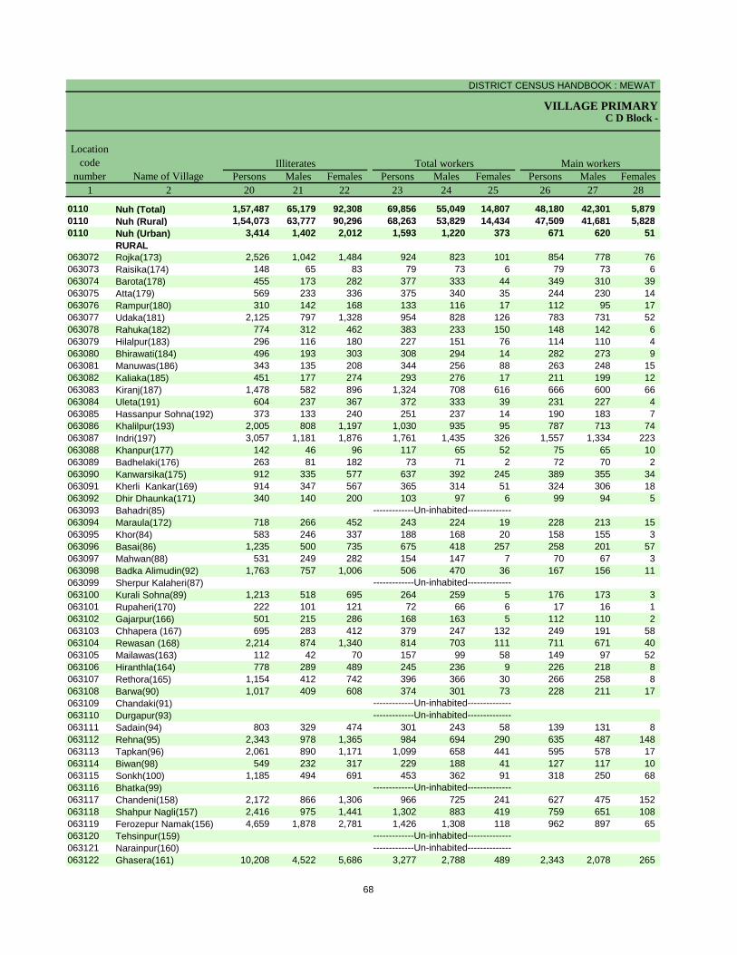
DISTRICT CENSUS HANDBOOK : MEWAT
VILLAGE PRIMARYC D Block -
Persons Males Females Persons Males Females Persons Males Females1 2 20 21 22 23 24 25 26 27 28
0110 Nuh (Total) 1,57,487 65,179 92,308 69,856 55,049 14,807 48,180 42,301 5,879 0110 Nuh (Rural) 1,54,073 63,777 90,296 68,263 53,829 14,434 47,509 41,681 5,828 0110 Nuh (Urban) 3,414 1,402 2,012 1,593 1,220 373 671 620 51
RURAL063072 Rojka(173) 2,526 1,042 1,484 924 823 101 854 778 76 063073 Raisika(174) 148 65 83 79 73 6 79 73 6 063074 Barota(178) 455 173 282 377 333 44 349 310 39 063075 Atta(179) 569 233 336 375 340 35 244 230 14 063076 Rampur(180) 310 142 168 133 116 17 112 95 17 063077 Udaka(181) 2,125 797 1,328 954 828 126 783 731 52 063078 Rahuka(182) 774 312 462 383 233 150 148 142 6 063079 Hilalpur(183) 296 116 180 227 151 76 114 110 4 063080 Bhirawati(184) 496 193 303 308 294 14 282 273 9 063081 Manuwas(186) 343 135 208 344 256 88 263 248 15 063082 Kaliaka(185) 451 177 274 293 276 17 211 199 12 063083 Kiranj(187) 1,478 582 896 1,324 708 616 666 600 66 063084 Uleta(191) 604 237 367 372 333 39 231 227 4 063085 Hassanpur Sohna(192) 373 133 240 251 237 14 190 183 7 063086 Khalilpur(193) 2,005 808 1,197 1,030 935 95 787 713 74 063087 Indri(197) 3,057 1,181 1,876 1,761 1,435 326 1,557 1,334 223 063088 Khanpur(177) 142 46 96 117 65 52 75 65 10 063089 Badhelaki(176) 263 81 182 73 71 2 72 70 2 063090 Kanwarsika(175) 912 335 577 637 392 245 389 355 34 063091 Kherli Kankar(169) 914 347 567 365 314 51 324 306 18 063092 Dhir Dhaunka(171) 340 140 200 103 97 6 99 94 5 063093 Bahadri(85)063094 Maraula(172) 718 266 452 243 224 19 228 213 15 063095 Khor(84) 583 246 337 188 168 20 158 155 3 063096 Basai(86) 1,235 500 735 675 418 257 258 201 57 063097 Mahwan(88) 531 249 282 154 147 7 70 67 3 063098 Badka Alimudin(92) 1,763 757 1,006 506 470 36 167 156 11 063099 Sherpur Kalaheri(87)063100 Kurali Sohna(89) 1,213 518 695 264 259 5 176 173 3 063101 Rupaheri(170) 222 101 121 72 66 6 17 16 1 063102 Gajarpur(166) 501 215 286 168 163 5 112 110 2 063103 Chhapera (167) 695 283 412 379 247 132 249 191 58 063104 Rewasan (168) 2,214 874 1,340 814 703 111 711 671 40 063105 Mailawas(163) 112 42 70 157 99 58 149 97 52 063106 Hiranthla(164) 778 289 489 245 236 9 226 218 8 063107 Rethora(165) 1,154 412 742 396 366 30 266 258 8 063108 Barwa(90) 1,017 409 608 374 301 73 228 211 17 063109 Chandaki(91)063110 Durgapur(93)063111 Sadain(94) 803 329 474 301 243 58 139 131 8 063112 Rehna(95) 2,343 978 1,365 984 694 290 635 487 148 063113 Tapkan(96) 2,061 890 1,171 1,099 658 441 595 578 17 063114 Biwan(98) 549 232 317 229 188 41 127 117 10 063115 Sonkh(100) 1,185 494 691 453 362 91 318 250 68 063116 Bhatka(99)063117 Chandeni(158) 2,172 866 1,306 966 725 241 627 475 152 063118 Shahpur Nagli(157) 2,416 975 1,441 1,302 883 419 759 651 108 063119 Ferozepur Namak(156) 4,659 1,878 2,781 1,426 1,308 118 962 897 65 063120 Tehsinpur(159)063121 Narainpur(160)063122 Ghasera(161) 10,208 4,522 5,686 3,277 2,788 489 2,343 2,078 265
-------------Un-inhabited--------------
-------------Un-inhabited--------------
-------------Un-inhabited--------------
-------------Un-inhabited---------------------------Un-inhabited--------------
-------------Un-inhabited--------------
-------------Un-inhabited--------------
Illiterates Total workers Main workersName of Village
Location code
number
68
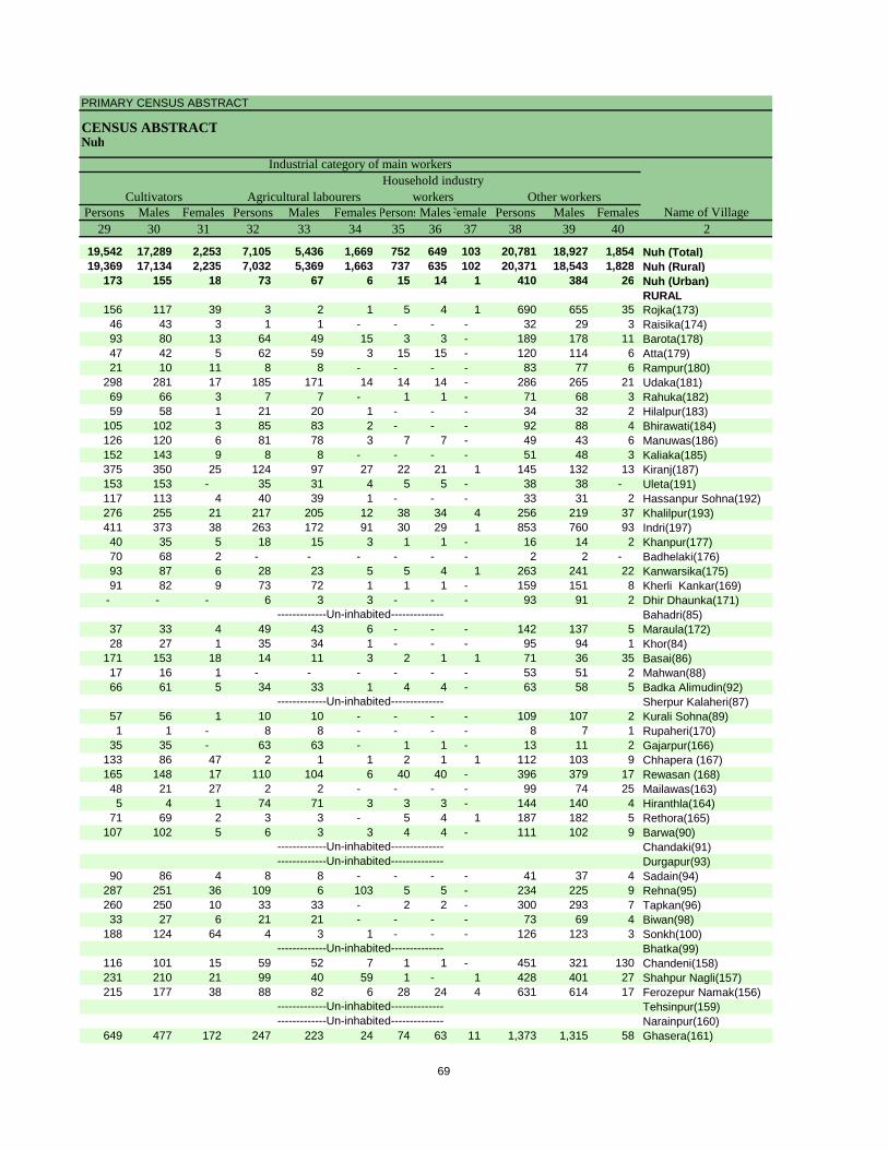
PRIMARY CENSUS ABSTRACT
CENSUS ABSTRACTNuh
Persons Males Females Persons Males Females PersonsMalesFemales Persons Males Females29 30 31 32 33 34 35 36 37 38 39 40 2
19,542 17,289 2,253 7,105 5,436 1,669 752 649 103 20,781 18,927 1,854 Nuh (Total)19,369 17,134 2,235 7,032 5,369 1,663 737 635 102 20,371 18,543 1,828 Nuh (Rural)
173 155 18 73 67 6 15 14 1 410 384 26 Nuh (Urban)RURAL
156 117 39 3 2 1 5 4 1 690 655 35 Rojka(173)46 43 3 1 1 - - - - 32 29 3 Raisika(174)93 80 13 64 49 15 3 3 - 189 178 11 Barota(178)47 42 5 62 59 3 15 15 - 120 114 6 Atta(179)21 10 11 8 8 - - - - 83 77 6 Rampur(180)
298 281 17 185 171 14 14 14 - 286 265 21 Udaka(181)69 66 3 7 7 - 1 1 - 71 68 3 Rahuka(182)59 58 1 21 20 1 - - - 34 32 2 Hilalpur(183)
105 102 3 85 83 2 - - - 92 88 4 Bhirawati(184)126 120 6 81 78 3 7 7 - 49 43 6 Manuwas(186)152 143 9 8 8 - - - - 51 48 3 Kaliaka(185)375 350 25 124 97 27 22 21 1 145 132 13 Kiranj(187)153 153 - 35 31 4 5 5 - 38 38 - Uleta(191)117 113 4 40 39 1 - - - 33 31 2 Hassanpur Sohna(192)276 255 21 217 205 12 38 34 4 256 219 37 Khalilpur(193)411 373 38 263 172 91 30 29 1 853 760 93 Indri(197)40 35 5 18 15 3 1 1 - 16 14 2 Khanpur(177)70 68 2 - - - - - - 2 2 - Badhelaki(176)93 87 6 28 23 5 5 4 1 263 241 22 Kanwarsika(175)91 82 9 73 72 1 1 1 - 159 151 8 Kherli Kankar(169)
- - - 6 3 3 - - - 93 91 2 Dhir Dhaunka(171)Bahadri(85)
37 33 4 49 43 6 - - - 142 137 5 Maraula(172)28 27 1 35 34 1 - - - 95 94 1 Khor(84)
171 153 18 14 11 3 2 1 1 71 36 35 Basai(86)17 16 1 - - - - - - 53 51 2 Mahwan(88)66 61 5 34 33 1 4 4 - 63 58 5 Badka Alimudin(92)
Sherpur Kalaheri(87)57 56 1 10 10 - - - - 109 107 2 Kurali Sohna(89)1 1 - 8 8 - - - - 8 7 1 Rupaheri(170)
35 35 - 63 63 - 1 1 - 13 11 2 Gajarpur(166)133 86 47 2 1 1 2 1 1 112 103 9 Chhapera (167)165 148 17 110 104 6 40 40 - 396 379 17 Rewasan (168)48 21 27 2 2 - - - - 99 74 25 Mailawas(163)5 4 1 74 71 3 3 3 - 144 140 4 Hiranthla(164)
71 69 2 3 3 - 5 4 1 187 182 5 Rethora(165)107 102 5 6 3 3 4 4 - 111 102 9 Barwa(90)
Chandaki(91)Durgapur(93)
90 86 4 8 8 - - - - 41 37 4 Sadain(94)287 251 36 109 6 103 5 5 - 234 225 9 Rehna(95)260 250 10 33 33 - 2 2 - 300 293 7 Tapkan(96)33 27 6 21 21 - - - - 73 69 4 Biwan(98)
188 124 64 4 3 1 - - - 126 123 3 Sonkh(100)Bhatka(99)
116 101 15 59 52 7 1 1 - 451 321 130 Chandeni(158)231 210 21 99 40 59 1 - 1 428 401 27 Shahpur Nagli(157)215 177 38 88 82 6 28 24 4 631 614 17 Ferozepur Namak(156)
Tehsinpur(159)Narainpur(160)
649 477 172 247 223 24 74 63 11 1,373 1,315 58 Ghasera(161)-------------Un-inhabited--------------
-------------Un-inhabited--------------
-------------Un-inhabited--------------
-------------Un-inhabited---------------------------Un-inhabited--------------
-------------Un-inhabited--------------
-------------Un-inhabited--------------
CultivatorsName of Village
Household industry workersAgricultural labourers
Industrial category of main workers
Other workers
69
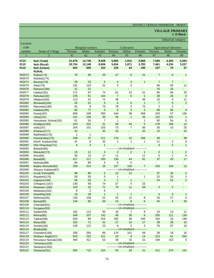
DISTRICT CENSUS HANDBOOK : MEWAT
VILLAGE PRIMARYC D Block -
Persons Males Females Persons Males Females Persons Males Females1 2 41 42 43 44 45 46 47 48 49
0110 Nuh (Total) 21,676 12,748 8,928 5,883 1,915 3,968 7,568 4,304 3,264 0110 Nuh (Rural) 20,754 12,148 8,606 5,654 1,871 3,783 7,461 4,234 3,227 0110 Nuh (Urban) 922 600 322 229 44 185 107 70 37
RURAL063072 Rojka(173) 70 45 25 27 6 21 7 6 1 063073 Raisika(174) - - - - - - - - - 063074 Barota(178) 28 23 5 4 3 1 7 7 - 063075 Atta(179) 131 110 21 3 3 - 66 55 11 063076 Rampur(180) 21 21 - - - - 15 15 - 063077 Udaka(181) 171 97 74 61 10 51 86 66 20 063078 Rahuka(182) 235 91 144 7 6 1 28 25 3 063079 Hilalpur(183) 113 41 72 46 - 46 15 4 11 063080 Bhirawati(184) 26 21 5 6 5 1 7 5 2 063081 Manuwas(186) 81 8 73 78 5 73 2 2 - 063082 Kaliaka(185) 82 77 5 5 3 2 69 66 3 063083 Kiranj(187) 658 108 550 444 36 408 193 57 136 063084 Uleta(191) 141 106 35 35 1 34 102 101 1 063085 Hassanpur Sohna(192) 61 54 7 1 - 1 60 54 6 063086 Khalilpur(193) 243 222 21 49 44 5 178 166 12 063087 Indri(197) 204 101 103 73 7 66 35 10 25 063088 Khanpur(177) 42 - 42 32 - 32 10 - 10 063089 Badhelaki(176) 1 1 - - - - - - - 063090 Kanwarsika(175) 248 37 211 176 10 166 38 - 38 063091 Kherli Kankar(169) 41 8 33 2 1 1 11 2 9 063092 Dhir Dhaunka(171) 4 3 1 - - - 3 2 1 063093 Bahadri(85)063094 Maraula(172) 15 11 4 3 2 1 3 1 2 063095 Khor(84) 30 13 17 11 - 11 5 1 4 063096 Basai(86) 417 217 200 135 44 91 37 20 17 063097 Mahwan(88) 84 80 4 5 5 - - - - 063098 Badka Alimudin(92) 339 314 25 107 100 7 155 143 12 063099 Sherpur Kalaheri(87)063100 Kurali Sohna(89) 88 86 2 12 12 - 37 35 2 063101 Rupaheri(170) 55 50 5 1 - 1 22 20 2 063102 Gajarpur(166) 56 53 3 1 1 - 54 52 2 063103 Chhapera (167) 130 56 74 27 4 23 - - - 063104 Rewasan (168) 103 32 71 70 11 59 2 2 - 063105 Mailawas(163) 8 2 6 - - - - - - 063106 Hiranthla(164) 19 18 1 1 1 - 4 3 1 063107 Rethora(165) 130 108 22 20 12 8 33 27 6 063108 Barwa(90) 146 90 56 15 9 6 40 4 36 063109 Chandaki(91)063110 Durgapur(93)063111 Sadain(94) 162 112 50 16 7 9 24 13 11 063112 Rehna(95) 349 207 142 45 39 6 255 121 134 063113 Tapkan(96) 504 80 424 282 36 246 164 16 148 063114 Biwan(98) 102 71 31 27 10 17 38 28 10 063115 Sonkh(100) 135 112 23 6 3 3 76 57 19 063116 Bhatka(99)063117 Chandeni(158) 339 250 89 170 101 69 28 18 10 063118 Shahpur Nagli(157) 543 232 311 23 9 14 313 61 252 063119 Ferozepur Namak(156) 464 411 53 38 16 22 159 153 6 063120 Tehsinpur(159)063121 Narainpur(160)063122 Ghasera(161) 934 710 224 55 34 21 411 270 141
-------------Un-inhabited--------------
-------------Un-inhabited--------------
-------------Un-inhabited--------------
-------------Un-inhabited---------------------------Un-inhabited--------------
-------------Un-inhabited--------------
-------------Un-inhabited--------------
Location code
number Name of VillageMarginal workers Cultivators Agricultural labourers
Industrial category
70
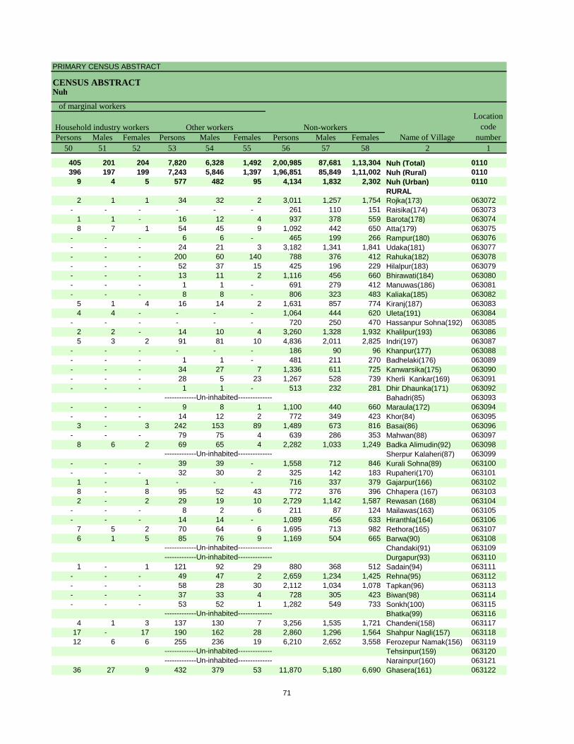
PRIMARY CENSUS ABSTRACT
CENSUS ABSTRACTNuh
Persons Males Females Persons Males Females Persons Males Females50 51 52 53 54 55 56 57 58 2 1
405 201 204 7,820 6,328 1,492 2,00,985 87,681 1,13,304 Nuh (Total) 0110396 197 199 7,243 5,846 1,397 1,96,851 85,849 1,11,002 Nuh (Rural) 0110
9 4 5 577 482 95 4,134 1,832 2,302 Nuh (Urban) 0110RURAL
2 1 1 34 32 2 3,011 1,257 1,754 Rojka(173) 063072- - - - - - 261 110 151 Raisika(174) 063073
1 1 - 16 12 4 937 378 559 Barota(178) 0630748 7 1 54 45 9 1,092 442 650 Atta(179) 063075
- - - 6 6 - 465 199 266 Rampur(180) 063076- - - 24 21 3 3,182 1,341 1,841 Udaka(181) 063077- - - 200 60 140 788 376 412 Rahuka(182) 063078- - - 52 37 15 425 196 229 Hilalpur(183) 063079- - - 13 11 2 1,116 456 660 Bhirawati(184) 063080- - - 1 1 - 691 279 412 Manuwas(186) 063081- - - 8 8 - 806 323 483 Kaliaka(185) 063082
5 1 4 16 14 2 1,631 857 774 Kiranj(187) 0630834 4 - - - - 1,064 444 620 Uleta(191) 063084
- - - - - - 720 250 470 Hassanpur Sohna(192) 0630852 2 - 14 10 4 3,260 1,328 1,932 Khalilpur(193) 0630865 3 2 91 81 10 4,836 2,011 2,825 Indri(197) 063087
- - - - - - 186 90 96 Khanpur(177) 063088- - - 1 1 - 481 211 270 Badhelaki(176) 063089- - - 34 27 7 1,336 611 725 Kanwarsika(175) 063090- - - 28 5 23 1,267 528 739 Kherli Kankar(169) 063091- - - 1 1 - 513 232 281 Dhir Dhaunka(171) 063092
Bahadri(85) 063093- - - 9 8 1 1,100 440 660 Maraula(172) 063094- - - 14 12 2 772 349 423 Khor(84) 063095
3 - 3 242 153 89 1,489 673 816 Basai(86) 063096- - - 79 75 4 639 286 353 Mahwan(88) 063097
8 6 2 69 65 4 2,282 1,033 1,249 Badka Alimudin(92) 063098Sherpur Kalaheri(87) 063099
- - - 39 39 - 1,558 712 846 Kurali Sohna(89) 063100- - - 32 30 2 325 142 183 Rupaheri(170) 063101
1 - 1 - - - 716 337 379 Gajarpur(166) 0631028 - 8 95 52 43 772 376 396 Chhapera (167) 0631032 - 2 29 19 10 2,729 1,142 1,587 Rewasan (168) 063104
- - - 8 2 6 211 87 124 Mailawas(163) 063105- - - 14 14 - 1,089 456 633 Hiranthla(164) 063106
7 5 2 70 64 6 1,695 713 982 Rethora(165) 0631076 1 5 85 76 9 1,169 504 665 Barwa(90) 063108
Chandaki(91) 063109Durgapur(93) 063110
1 - 1 121 92 29 880 368 512 Sadain(94) 063111- - - 49 47 2 2,659 1,234 1,425 Rehna(95) 063112- - - 58 28 30 2,112 1,034 1,078 Tapkan(96) 063113- - - 37 33 4 728 305 423 Biwan(98) 063114- - - 53 52 1 1,282 549 733 Sonkh(100) 063115
Bhatka(99) 0631164 1 3 137 130 7 3,256 1,535 1,721 Chandeni(158) 063117
17 - 17 190 162 28 2,860 1,296 1,564 Shahpur Nagli(157) 06311812 6 6 255 236 19 6,210 2,652 3,558 Ferozepur Namak(156) 063119
Tehsinpur(159) 063120Narainpur(160) 063121
36 27 9 432 379 53 11,870 5,180 6,690 Ghasera(161) 063122-------------Un-inhabited--------------
-------------Un-inhabited--------------
-------------Un-inhabited--------------
-------------Un-inhabited---------------------------Un-inhabited--------------
-------------Un-inhabited--------------
-------------Un-inhabited--------------
Non-workers
of marginal workersLocation
code number
Household industry workersName of Village
Other workers
71
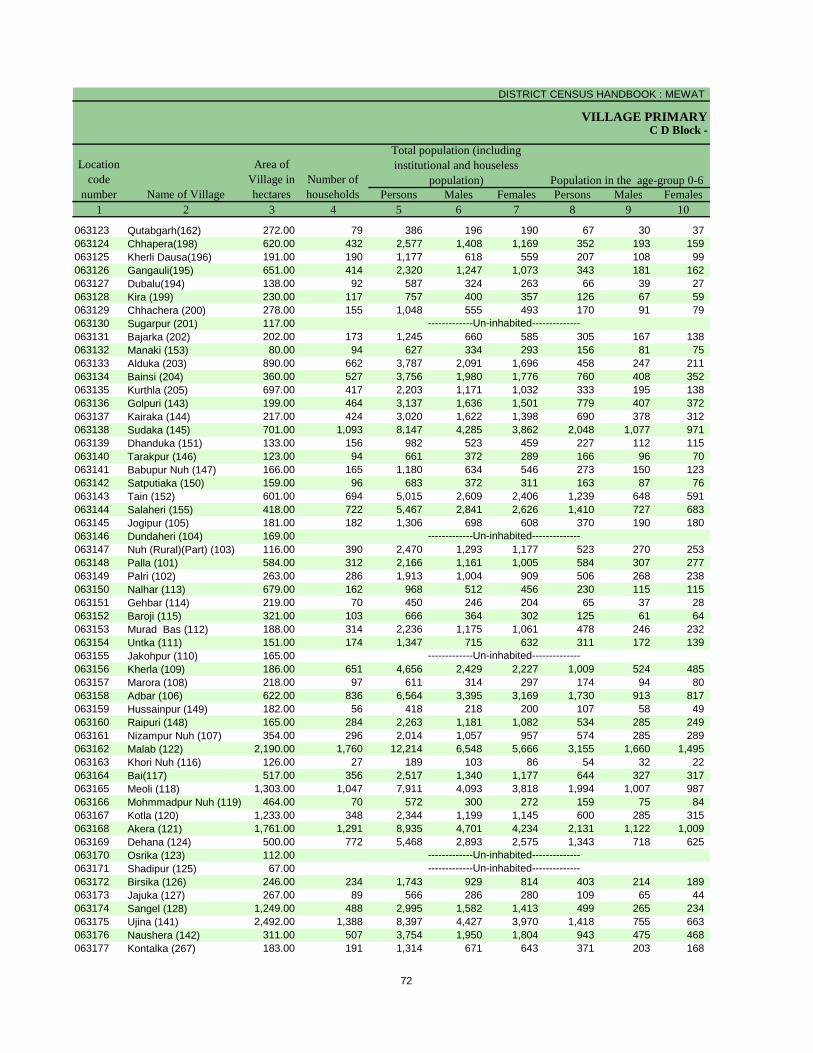
DISTRICT CENSUS HANDBOOK : MEWAT
VILLAGE PRIMARY
Persons Males Females Persons Males Females1 2 3 4 5 6 7 8 9 10
C D Block -
Population in the age-group 0-6Name of Village
Location code
number
Total population (including institutional and houseless
population)Area of
Village in hectares
Number of households
063123 Qutabgarh(162) 272.00 79 386 196 190 67 30 37 063124 Chhapera(198) 620.00 432 2,577 1,408 1,169 352 193 159 063125 Kherli Dausa(196) 191.00 190 1,177 618 559 207 108 99 063126 Gangauli(195) 651.00 414 2,320 1,247 1,073 343 181 162 063127 Dubalu(194) 138.00 92 587 324 263 66 39 27 063128 Kira (199) 230.00 117 757 400 357 126 67 59 063129 Chhachera (200) 278.00 155 1,048 555 493 170 91 79 063130 Sugarpur (201) 117.00063131 Bajarka (202) 202.00 173 1,245 660 585 305 167 138 063132 Manaki (153) 80.00 94 627 334 293 156 81 75 063133 Alduka (203) 890.00 662 3,787 2,091 1,696 458 247 211 063134 Bainsi (204) 360.00 527 3,756 1,980 1,776 760 408 352 063135 Kurthla (205) 697.00 417 2,203 1,171 1,032 333 195 138 063136 Golpuri (143) 199.00 464 3,137 1,636 1,501 779 407 372 063137 Kairaka (144) 217.00 424 3,020 1,622 1,398 690 378 312 063138 Sudaka (145) 701.00 1,093 8,147 4,285 3,862 2,048 1,077 971 063139 Dhanduka (151) 133.00 156 982 523 459 227 112 115 063140 Tarakpur (146) 123.00 94 661 372 289 166 96 70 063141 Babupur Nuh (147) 166.00 165 1,180 634 546 273 150 123 063142 Satputiaka (150) 159.00 96 683 372 311 163 87 76 063143 Tain (152) 601.00 694 5,015 2,609 2,406 1,239 648 591 063144 Salaheri (155) 418.00 722 5,467 2,841 2,626 1,410 727 683 063145 Jogipur (105) 181.00 182 1,306 698 608 370 190 180 063146 Dundaheri (104) 169.00063147 Nuh (Rural)(Part) (103) 116.00 390 2,470 1,293 1,177 523 270 253 063148 Palla (101) 584.00 312 2,166 1,161 1,005 584 307 277 063149 Palri (102) 263.00 286 1,913 1,004 909 506 268 238 063150 Nalhar (113) 679.00 162 968 512 456 230 115 115 063151 Gehbar (114) 219.00 70 450 246 204 65 37 28 063152 Baroji (115) 321.00 103 666 364 302 125 61 64 063153 Murad Bas (112) 188.00 314 2,236 1,175 1,061 478 246 232 063154 Untka (111) 151.00 174 1,347 715 632 311 172 139 063155 Jakohpur (110) 165.00063156 Kherla (109) 186.00 651 4,656 2,429 2,227 1,009 524 485 063157 Marora (108) 218.00 97 611 314 297 174 94 80 063158 Adbar (106) 622.00 836 6,564 3,395 3,169 1,730 913 817 063159 Hussainpur (149) 182.00 56 418 218 200 107 58 49 063160 Raipuri (148) 165.00 284 2,263 1,181 1,082 534 285 249 063161 Nizampur Nuh (107) 354.00 296 2,014 1,057 957 574 285 289 063162 Malab (122) 2,190.00 1,760 12,214 6,548 5,666 3,155 1,660 1,495 063163 Khori Nuh (116) 126.00 27 189 103 86 54 32 22 063164 Bai(117) 517.00 356 2,517 1,340 1,177 644 327 317 063165 Meoli (118) 1,303.00 1,047 7,911 4,093 3,818 1,994 1,007 987 063166 Mohmmadpur Nuh (119) 464.00 70 572 300 272 159 75 84 063167 Kotla (120) 1,233.00 348 2,344 1,199 1,145 600 285 315 063168 Akera (121) 1,761.00 1,291 8,935 4,701 4,234 2,131 1,122 1,009 063169 Dehana (124) 500.00 772 5,468 2,893 2,575 1,343 718 625 063170 Osrika (123) 112.00063171 Shadipur (125) 67.00063172 Birsika (126) 246.00 234 1,743 929 814 403 214 189 063173 Jajuka (127) 267.00 89 566 286 280 109 65 44 063174 Sangel (128) 1,249.00 488 2,995 1,582 1,413 499 265 234 063175 Ujina (141) 2,492.00 1,388 8,397 4,427 3,970 1,418 755 663 063176 Naushera (142) 311.00 507 3,754 1,950 1,804 943 475 468 063177 Kontalka (267) 183.00 191 1,314 671 643 371 203 168
-------------Un-inhabited---------------------------Un-inhabited--------------
-------------Un-inhabited--------------
-------------Un-inhabited--------------
-------------Un-inhabited--------------
72
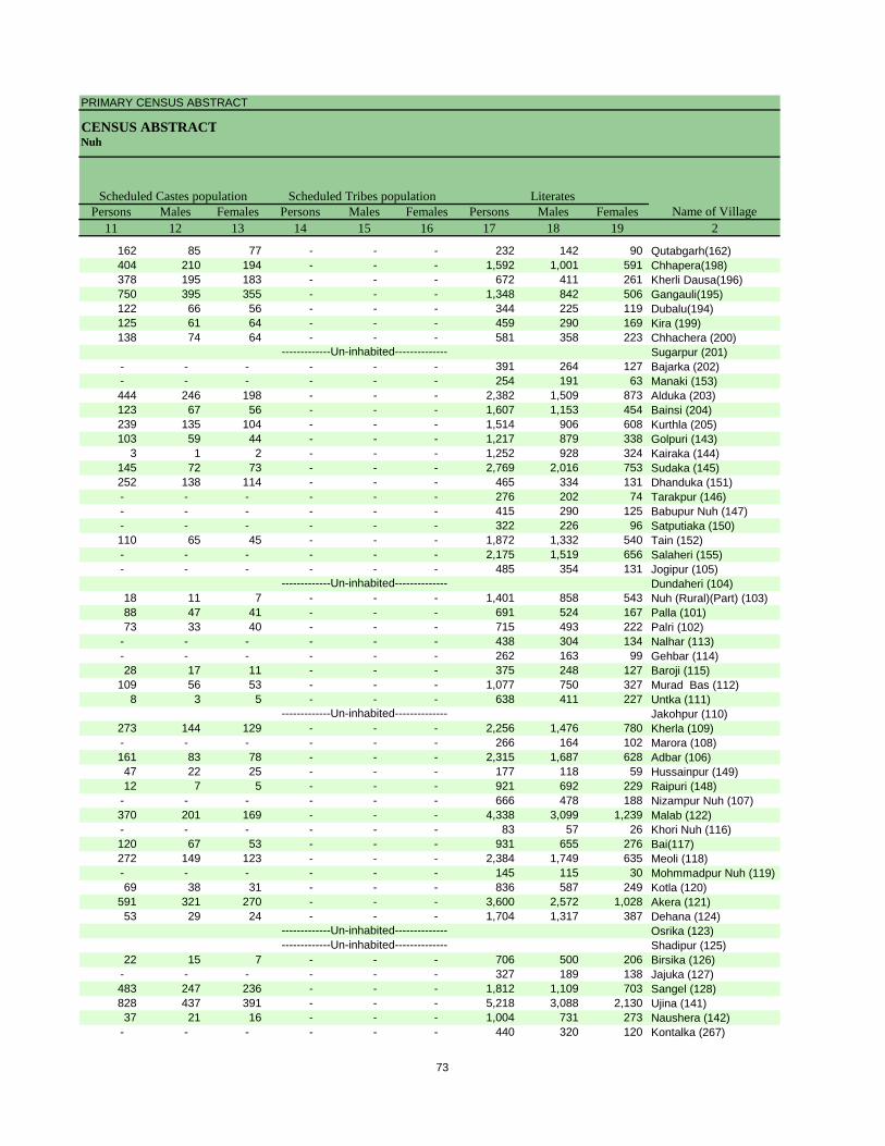
PRIMARY CENSUS ABSTRACT
CENSUS ABSTRACTNuh
Persons Males Females Persons Males Females Persons Males Females11 12 13 14 15 16 17 18 19 2
Scheduled Castes population Scheduled Tribes populationName of Village
Literates
162 85 77 - - - 232 142 90 Qutabgarh(162)404 210 194 - - - 1,592 1,001 591 Chhapera(198)378 195 183 - - - 672 411 261 Kherli Dausa(196)750 395 355 - - - 1,348 842 506 Gangauli(195)122 66 56 - - - 344 225 119 Dubalu(194)125 61 64 - - - 459 290 169 Kira (199)138 74 64 - - - 581 358 223 Chhachera (200)
Sugarpur (201)- - - - - - 391 264 127 Bajarka (202)- - - - - - 254 191 63 Manaki (153)444 246 198 - - - 2,382 1,509 873 Alduka (203)123 67 56 - - - 1,607 1,153 454 Bainsi (204)239 135 104 - - - 1,514 906 608 Kurthla (205)103 59 44 - - - 1,217 879 338 Golpuri (143)
3 1 2 - - - 1,252 928 324 Kairaka (144)145 72 73 - - - 2,769 2,016 753 Sudaka (145)252 138 114 - - - 465 334 131 Dhanduka (151)- - - - - - 276 202 74 Tarakpur (146)- - - - - - 415 290 125 Babupur Nuh (147)- - - - - - 322 226 96 Satputiaka (150)110 65 45 - - - 1,872 1,332 540 Tain (152)- - - - - - 2,175 1,519 656 Salaheri (155)- - - - - - 485 354 131 Jogipur (105)
Dundaheri (104)18 11 7 - - - 1,401 858 543 Nuh (Rural)(Part) (103)88 47 41 - - - 691 524 167 Palla (101)73 33 40 - - - 715 493 222 Palri (102)
- - - - - - 438 304 134 Nalhar (113)- - - - - - 262 163 99 Gehbar (114)28 17 11 - - - 375 248 127 Baroji (115)
109 56 53 - - - 1,077 750 327 Murad Bas (112)8 3 5 - - - 638 411 227 Untka (111)
Jakohpur (110)273 144 129 - - - 2,256 1,476 780 Kherla (109)- - - - - - 266 164 102 Marora (108)161 83 78 - - - 2,315 1,687 628 Adbar (106)47 22 25 - - - 177 118 59 Hussainpur (149)12 7 5 - - - 921 692 229 Raipuri (148)
- - - - - - 666 478 188 Nizampur Nuh (107)370 201 169 - - - 4,338 3,099 1,239 Malab (122)- - - - - - 83 57 26 Khori Nuh (116)120 67 53 - - - 931 655 276 Bai(117)272 149 123 - - - 2,384 1,749 635 Meoli (118)- - - - - - 145 115 30 Mohmmadpur Nuh (119)69 38 31 - - - 836 587 249 Kotla (120)
591 321 270 - - - 3,600 2,572 1,028 Akera (121)53 29 24 - - - 1,704 1,317 387 Dehana (124)
Osrika (123)Shadipur (125)
22 15 7 - - - 706 500 206 Birsika (126)- - - - - - 327 189 138 Jajuka (127)483 247 236 - - - 1,812 1,109 703 Sangel (128)828 437 391 - - - 5,218 3,088 2,130 Ujina (141)37 21 16 - - - 1,004 731 273 Naushera (142)
- - - - - - 440 320 120 Kontalka (267)
-------------Un-inhabited---------------------------Un-inhabited--------------
-------------Un-inhabited--------------
-------------Un-inhabited--------------
-------------Un-inhabited--------------
73
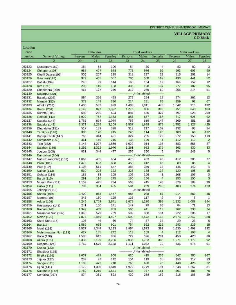
DISTRICT CENSUS HANDBOOK : MEWAT
VILLAGE PRIMARYC D Block -
Persons Males Females Persons Males Females Persons Males Females1 2 20 21 22 23 24 25 26 27 28
Illiterates Total workers Main workersName of Village
Location code
number
063123 Qutabgarh(162) 154 54 100 84 80 4 83 80 3 063124 Chhapera(198) 985 407 578 772 676 96 693 603 90 063125 Kherli Dausa(196) 505 207 298 319 297 22 215 201 14 063126 Gangauli(195) 972 405 567 760 568 192 493 441 52 063127 Dubalu(194) 243 99 144 166 154 12 164 152 12 063128 Kira (199) 298 110 188 335 198 137 277 182 95 063129 Chhachera (200) 467 197 270 319 259 60 265 214 51 063130 Sugarpur (201)063131 Bajarka (202) 854 396 458 276 264 12 274 262 12 063132 Manaki (153) 373 143 230 214 131 83 159 92 67 063133 Alduka (203) 1,405 582 823 1,489 1,011 478 1,042 910 132 063134 Bainsi (204) 2,149 827 1,322 1,276 886 390 751 648 103 063135 Kurthla (205) 689 265 424 887 560 327 797 528 269 063136 Golpuri (143) 1,920 757 1,163 855 667 188 717 625 92 063137 Kairaka (144) 1,768 694 1,074 766 619 147 369 351 18 063138 Sudaka (145) 5,378 2,269 3,109 2,537 1,658 879 1,752 1,327 425 063139 Dhanduka (151) 517 189 328 319 217 102 132 98 34 063140 Tarakpur (146) 385 170 215 240 114 126 188 66 122 063141 Babupur Nuh (147) 765 344 421 327 205 122 272 153 119 063142 Satputiaka (150) 361 146 215 133 129 4 112 110 2 063143 Tain (152) 3,143 1,277 1,866 1,022 914 108 583 556 27 063144 Salaheri (155) 3,292 1,322 1,970 1,261 982 279 863 830 33 063145 Jogipur (105) 821 344 477 255 250 5 254 249 5 063146 Dundaheri (104)063147 Nuh (Rural)(Part) (103) 1,069 435 634 476 433 43 412 385 27 063148 Palla (101) 1,475 637 838 458 412 46 89 85 4 063149 Palri (102) 1,198 511 687 384 369 15 146 142 4 063150 Nalhar (113) 530 208 322 325 188 137 120 105 15 063151 Gehbar (114) 188 83 105 109 106 3 108 105 3 063152 Baroji (115) 291 116 175 160 156 4 153 150 3 063153 Murad Bas (112) 1,159 425 734 563 415 148 379 289 90 063154 Untka (111) 709 304 405 584 289 295 403 274 129 063155 Jakohpur (110)063156 Kherla (109) 2,400 953 1,447 985 928 57 914 869 45 063157 Marora (108) 345 150 195 126 117 9 9 8 1 063158 Adbar (106) 4,249 1,708 2,541 1,676 1,280 396 1,232 1,088 144 063159 Hussainpur (149) 241 100 141 147 79 68 84 71 13 063160 Raipuri (148) 1,342 489 853 560 441 119 262 238 24 063161 Nizampur Nuh (107) 1,348 579 769 502 368 134 222 205 17 063162 Malab (122) 7,876 3,449 4,427 3,690 2,572 1,118 2,575 2,247 328 063163 Khori Nuh (116) 106 46 60 74 37 37 29 23 6 063164 Bai(117) 1,586 685 901 754 522 232 243 225 18 063165 Meoli (118) 5,527 2,344 3,183 1,954 1,573 381 1,630 1,498 132 063166 Mohmmadpur Nuh (119) 427 185 242 113 109 4 112 108 4 063167 Kotla (120) 1,508 612 896 727 526 201 458 428 30 063168 Akera (121) 5,335 2,129 3,206 2,036 1,733 303 1,271 1,179 92 063169 Dehana (124) 3,764 1,576 2,188 1,111 1,032 79 735 674 61 063170 Osrika (123)063171 Shadipur (125)063172 Birsika (126) 1,037 429 608 620 415 205 547 380 167 063173 Jajuka (127) 239 97 142 154 119 35 150 117 33 063174 Sangel (128) 1,183 473 710 766 690 76 448 426 22 063175 Ujina (141) 3,179 1,339 1,840 1,970 1,779 191 1,348 1,267 81 063176 Naushera (142) 2,750 1,219 1,531 938 777 161 561 485 76 063177 Kontalka (267) 874 351 523 420 258 162 215 186 29
-------------Un-inhabited---------------------------Un-inhabited--------------
-------------Un-inhabited--------------
-------------Un-inhabited--------------
-------------Un-inhabited--------------
74
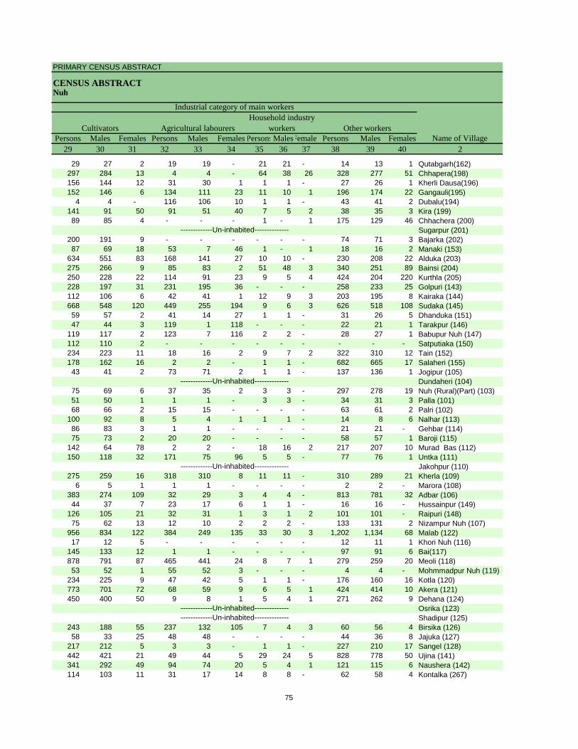
PRIMARY CENSUS ABSTRACT
CENSUS ABSTRACTNuh
Persons Males Females Persons Males Females PersonsMalesFemales Persons Males Females29 30 31 32 33 34 35 36 37 38 39 40 2
CultivatorsName of Village
Household industry workersAgricultural labourers
Industrial category of main workers
Other workers
29 27 2 19 19 - 21 21 - 14 13 1 Qutabgarh(162)297 284 13 4 4 - 64 38 26 328 277 51 Chhapera(198)156 144 12 31 30 1 1 1 - 27 26 1 Kherli Dausa(196)152 146 6 134 111 23 11 10 1 196 174 22 Gangauli(195)
4 4 - 116 106 10 1 1 - 43 41 2 Dubalu(194)141 91 50 91 51 40 7 5 2 38 35 3 Kira (199)89 85 4 - - - 1 - 1 175 129 46 Chhachera (200)
Sugarpur (201)200 191 9 - - - - - - 74 71 3 Bajarka (202)87 69 18 53 7 46 1 - 1 18 16 2 Manaki (153)
634 551 83 168 141 27 10 10 - 230 208 22 Alduka (203)275 266 9 85 83 2 51 48 3 340 251 89 Bainsi (204)250 228 22 114 91 23 9 5 4 424 204 220 Kurthla (205)228 197 31 231 195 36 - - - 258 233 25 Golpuri (143)112 106 6 42 41 1 12 9 3 203 195 8 Kairaka (144)668 548 120 449 255 194 9 6 3 626 518 108 Sudaka (145)59 57 2 41 14 27 1 1 - 31 26 5 Dhanduka (151)47 44 3 119 1 118 - - - 22 21 1 Tarakpur (146)
119 117 2 123 7 116 2 2 - 28 27 1 Babupur Nuh (147)112 110 2 - - - - - - - - - Satputiaka (150)234 223 11 18 16 2 9 7 2 322 310 12 Tain (152)178 162 16 2 2 - 1 1 - 682 665 17 Salaheri (155)43 41 2 73 71 2 1 1 - 137 136 1 Jogipur (105)
Dundaheri (104)75 69 6 37 35 2 3 3 - 297 278 19 Nuh (Rural)(Part) (103)51 50 1 1 1 - 3 3 - 34 31 3 Palla (101)68 66 2 15 15 - - - - 63 61 2 Palri (102)
100 92 8 5 4 1 1 1 - 14 8 6 Nalhar (113)86 83 3 1 1 - - - - 21 21 - Gehbar (114)75 73 2 20 20 - - - - 58 57 1 Baroji (115)
142 64 78 2 2 - 18 16 2 217 207 10 Murad Bas (112)150 118 32 171 75 96 5 5 - 77 76 1 Untka (111)
Jakohpur (110)275 259 16 318 310 8 11 11 - 310 289 21 Kherla (109)
6 5 1 1 1 - - - - 2 2 - Marora (108)383 274 109 32 29 3 4 4 - 813 781 32 Adbar (106)44 37 7 23 17 6 1 1 - 16 16 - Hussainpur (149)
126 105 21 32 31 1 3 1 2 101 101 - Raipuri (148)75 62 13 12 10 2 2 2 - 133 131 2 Nizampur Nuh (107)
956 834 122 384 249 135 33 30 3 1,202 1,134 68 Malab (122)17 12 5 - - - - - - 12 11 1 Khori Nuh (116)
145 133 12 1 1 - - - - 97 91 6 Bai(117)878 791 87 465 441 24 8 7 1 279 259 20 Meoli (118)53 52 1 55 52 3 - - - 4 4 - Mohmmadpur Nuh (119)
234 225 9 47 42 5 1 1 - 176 160 16 Kotla (120)773 701 72 68 59 9 6 5 1 424 414 10 Akera (121)450 400 50 9 8 1 5 4 1 271 262 9 Dehana (124)
Osrika (123)Shadipur (125)
243 188 55 237 132 105 7 4 3 60 56 4 Birsika (126)58 33 25 48 48 - - - - 44 36 8 Jajuka (127)
217 212 5 3 3 - 1 1 - 227 210 17 Sangel (128)442 421 21 49 44 5 29 24 5 828 778 50 Ujina (141)341 292 49 94 74 20 5 4 1 121 115 6 Naushera (142)114 103 11 31 17 14 8 8 - 62 58 4 Kontalka (267)
-------------Un-inhabited---------------------------Un-inhabited--------------
-------------Un-inhabited--------------
-------------Un-inhabited--------------
-------------Un-inhabited--------------
75
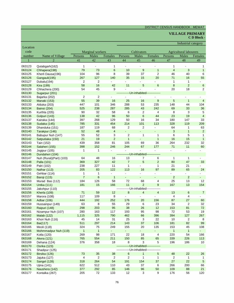
DISTRICT CENSUS HANDBOOK : MEWAT
VILLAGE PRIMARYC D Block -
Persons Males Females Persons Males Females Persons Males Females1 2 41 42 43 44 45 46 47 48 49
Location code
number Name of VillageMarginal workers Cultivators Agricultural labourers
Industrial category
063123 Qutabgarh(162) 1 - 1 - - - 1 - 1 063124 Chhapera(198) 79 73 6 10 9 1 4 3 1 063125 Kherli Dausa(196) 104 96 8 39 37 2 46 40 6 063126 Gangauli(195) 267 127 140 35 15 20 71 16 55 063127 Dubalu(194) 2 2 - - - - 1 1 - 063128 Kira (199) 58 16 42 11 5 6 8 2 6 063129 Chhachera (200) 54 45 9 - - - 20 18 2 063130 Sugarpur (201)063131 Bajarka (202) 2 2 - - - - - - - 063132 Manaki (153) 55 39 16 25 16 9 5 1 4 063133 Alduka (203) 447 101 346 288 53 235 148 44 104 063134 Bainsi (204) 525 238 287 285 43 242 69 33 36 063135 Kurthla (205) 90 32 58 6 2 4 8 3 5 063136 Golpuri (143) 138 42 96 50 6 44 23 19 4 063137 Kairaka (144) 397 268 129 50 16 34 180 147 33 063138 Sudaka (145) 785 331 454 214 101 113 328 119 209 063139 Dhanduka (151) 187 119 68 2 2 - 64 1 63 063140 Tarakpur (146) 52 48 4 - - - 3 1 2 063141 Babupur Nuh (147) 55 52 3 2 1 1 6 5 1 063142 Satputiaka (150) 21 19 2 1 - 1 16 15 1 063143 Tain (152) 439 358 81 105 69 36 264 232 32 063144 Salaheri (155) 398 152 246 244 67 177 71 11 60 063145 Jogipur (105) 1 1 - - - - - - - 063146 Dundaheri (104)063147 Nuh (Rural)(Part) (103) 64 48 16 13 7 6 1 1 - 063148 Palla (101) 369 327 42 7 5 2 80 47 33 063149 Palri (102) 238 227 11 1 - 1 21 21 - 063150 Nalhar (113) 205 83 122 113 16 97 89 65 24 063151 Gehbar (114) 1 1 - - - - - - - 063152 Baroji (115) 7 6 1 - - - 2 2 - 063153 Murad Bas (112) 184 126 58 72 68 4 25 13 12 063154 Untka (111) 181 15 166 11 2 9 167 13 154 063155 Jakohpur (110)063156 Kherla (109) 71 59 12 8 4 4 13 6 7 063157 Marora (108) 117 109 8 - - - 4 4 - 063158 Adbar (106) 444 192 252 176 20 156 87 27 60 063159 Hussainpur (149) 63 8 55 29 6 23 34 2 32 063160 Raipuri (148) 298 203 95 38 26 12 153 81 72 063161 Nizampur Nuh (107) 280 163 117 193 95 98 72 53 19 063162 Malab (122) 1,115 325 790 462 66 396 394 127 267 063163 Khori Nuh (116) 45 14 31 25 3 22 10 2 8 063164 Bai(117) 511 297 214 143 37 106 181 82 99 063165 Meoli (118) 324 75 249 155 20 135 153 45 108 063166 Mohmmadpur Nuh (119) 1 1 - - - - 1 1 - 063167 Kotla (120) 269 98 171 22 18 4 220 54 166 063168 Akera (121) 765 554 211 150 85 65 339 226 113 063169 Dehana (124) 376 358 18 8 3 5 196 186 10 063170 Osrika (123)063171 Shadipur (125)063172 Birsika (126) 73 35 38 6 1 5 48 22 26 063173 Jajuka (127) 4 2 2 2 1 1 2 1 1 063174 Sangel (128) 318 264 54 191 154 37 27 22 5 063175 Ujina (141) 622 512 110 43 37 6 266 200 66 063176 Naushera (142) 377 292 85 146 96 50 109 88 21 063177 Kontalka (267) 205 72 133 12 3 9 176 56 120
-------------Un-inhabited---------------------------Un-inhabited--------------
-------------Un-inhabited--------------
-------------Un-inhabited--------------
-------------Un-inhabited--------------
76
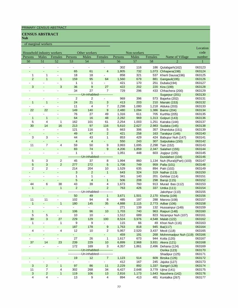
PRIMARY CENSUS ABSTRACT
CENSUS ABSTRACTNuh
Persons Males Females Persons Males Females Persons Males Females50 51 52 53 54 55 56 57 58 2 1
Non-workers
of marginal workersLocation
code number
Household industry workersName of Village
Other workers
- - - - - - 302 116 186 Qutabgarh(162) 063123- - - 65 61 4 1,805 732 1,073 Chhapera(198) 063124
1 1 - 18 18 - 858 321 537 Kherli Dausa(196) 0631252 1 1 159 95 64 1,560 679 881 Gangauli(195) 063126
- - - 1 1 - 421 170 251 Dubalu(194) 0631273 - 3 36 9 27 422 202 220 Kira (199) 063128
- - - 34 27 7 729 296 433 Chhachera (200) 063129Sugarpur (201) 063130
- - - 2 2 - 969 396 573 Bajarka (202) 0631311 1 - 24 21 3 413 203 210 Manaki (153) 063132
- - - 11 4 7 2,298 1,080 1,218 Alduka (203) 06313322 22 - 149 140 9 2,480 1,094 1,386 Bainsi (204) 063134
- - - 76 27 49 1,316 611 705 Kurthla (205) 0631351 1 - 64 16 48 2,282 969 1,313 Golpuri (143) 0631365 4 1 162 101 61 2,254 1,003 1,251 Kairaka (144) 063137
30 14 16 213 97 116 5,610 2,627 2,983 Sudaka (145) 063138- - - 121 116 5 663 306 357 Dhanduka (151) 063139- - - 49 47 2 421 258 163 Tarakpur (146) 063140
3 3 - 44 43 1 853 429 424 Babupur Nuh (147) 063141- - - 4 4 - 550 243 307 Satputiaka (150) 06314211 7 4 59 50 9 3,993 1,695 2,298 Tain (152) 063143
- - - 83 74 9 4,206 1,859 2,347 Salaheri (155) 063144- - - 1 1 - 1,051 448 603 Jogipur (105) 063145
Dundaheri (104) 0631465 3 2 45 37 8 1,994 860 1,134 Nuh (Rural)(Part) (103) 0631475 3 2 277 272 5 1,708 749 959 Palla (101) 0631482 2 - 214 204 10 1,529 635 894 Palri (102) 063149
- - - 3 2 1 643 324 319 Nalhar (113) 063150- - - 1 1 - 341 140 201 Gehbar (114) 063151- - - 5 4 1 506 208 298 Baroji (115) 06315244 6 38 43 39 4 1,673 760 913 Murad Bas (112) 0631531 - 1 2 - 2 763 426 337 Untka (111) 063154
Jakohpur (110) 063155- - - 50 49 1 3,671 1,501 2,170 Kherla (109) 06315611 11 - 102 94 8 485 197 288 Marora (108) 0631571 - 1 180 145 35 4,888 2,115 2,773 Adbar (106) 063158
- - - - - - 271 139 132 Hussainpur (149) 0631591 - 1 106 96 10 1,703 740 963 Raipuri (148) 0631605 5 - 10 10 - 1,512 689 823 Nizampur Nuh (107) 063161
30 3 27 229 129 100 8,524 3,976 4,548 Malab (122) 0631621 - 1 9 9 - 115 66 49 Khori Nuh (116) 063163
- - - 187 178 9 1,763 818 945 Bai(117) 0631644 - 4 12 10 2 5,957 2,520 3,437 Meoli (118) 063165
- - - - - - 459 191 268 Mohmmadpur Nuh (119) 063166- - - 27 26 1 1,617 673 944 Kotla (120) 06316737 14 23 239 229 10 6,899 2,968 3,931 Akera (121) 063168
- - - 172 169 3 4,357 1,861 2,496 Dehana (124) 063169Osrika (123) 063170Shadipur (125) 063171
- - - 19 12 7 1,123 514 609 Birsika (126) 063172- - - - - - 412 167 245 Jajuka (127) 063173
3 2 1 97 86 11 2,229 892 1,337 Sangel (128) 06317411 7 4 302 268 34 6,427 2,648 3,779 Ujina (141) 0631753 2 1 119 106 13 2,816 1,173 1,643 Naushera (142) 0631764 4 - 13 9 4 894 413 481 Kontalka (267) 063177
-------------Un-inhabited---------------------------Un-inhabited--------------
-------------Un-inhabited--------------
-------------Un-inhabited--------------
-------------Un-inhabited--------------
77
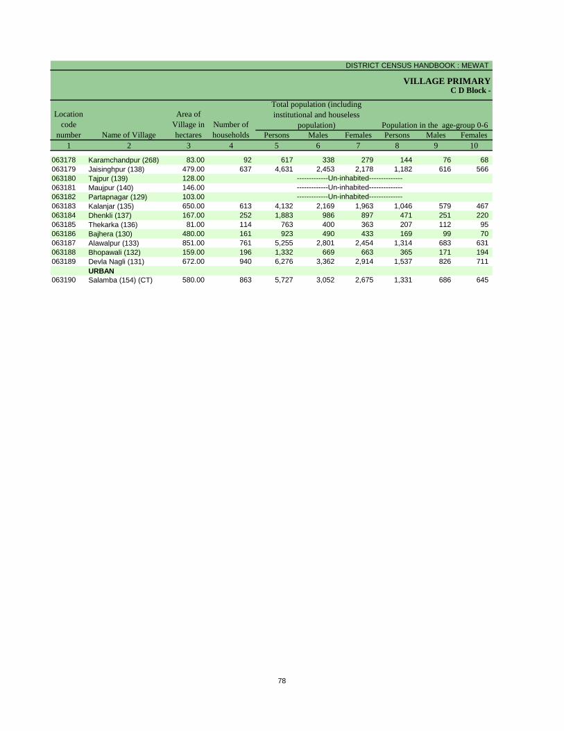
DISTRICT CENSUS HANDBOOK : MEWAT
VILLAGE PRIMARY
Persons Males Females Persons Males Females1 2 3 4 5 6 7 8 9 10
C D Block -
Population in the age-group 0-6Name of Village
Location code
number
Total population (including institutional and houseless
population)Area of
Village in hectares
Number of households
063178 Karamchandpur (268) 83.00 92 617 338 279 144 76 68 063179 Jaisinghpur (138) 479.00 637 4,631 2,453 2,178 1,182 616 566 063180 Tajpur (139) 128.00063181 Maujpur (140) 146.00063182 Partapnagar (129) 103.00063183 Kalanjar (135) 650.00 613 4,132 2,169 1,963 1,046 579 467 063184 Dhenkli (137) 167.00 252 1,883 986 897 471 251 220 063185 Thekarka (136) 81.00 114 763 400 363 207 112 95 063186 Bajhera (130) 480.00 161 923 490 433 169 99 70 063187 Alawalpur (133) 851.00 761 5,255 2,801 2,454 1,314 683 631 063188 Bhopawali (132) 159.00 196 1,332 669 663 365 171 194 063189 Devla Nagli (131) 672.00 940 6,276 3,362 2,914 1,537 826 711
URBAN063190 Salamba (154) (CT) 580.00 863 5,727 3,052 2,675 1,331 686 645
-------------Un-inhabited--------------
-------------Un-inhabited---------------------------Un-inhabited--------------
78
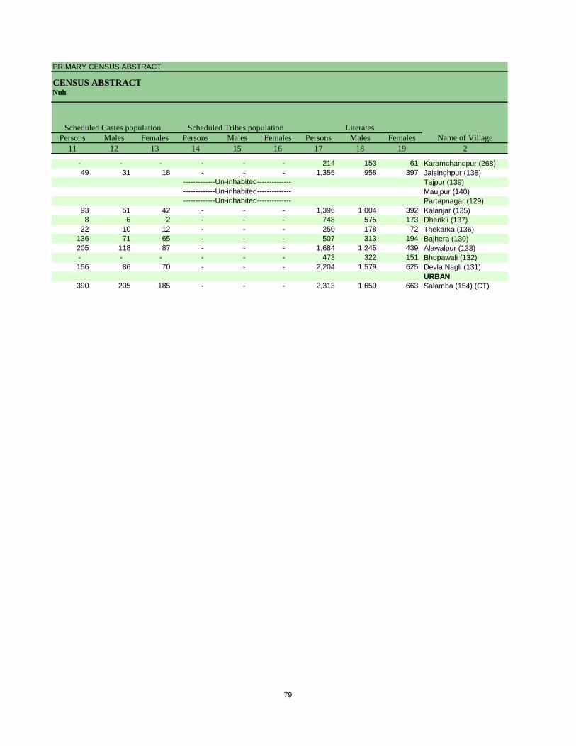
PRIMARY CENSUS ABSTRACT
CENSUS ABSTRACTNuh
Persons Males Females Persons Males Females Persons Males Females11 12 13 14 15 16 17 18 19 2
Scheduled Castes population Scheduled Tribes populationName of Village
Literates
- - - - - - 214 153 61 Karamchandpur (268)49 31 18 - - - 1,355 958 397 Jaisinghpur (138)
Tajpur (139)Maujpur (140)Partapnagar (129)
93 51 42 - - - 1,396 1,004 392 Kalanjar (135)8 6 2 - - - 748 575 173 Dhenkli (137)
22 10 12 - - - 250 178 72 Thekarka (136)136 71 65 - - - 507 313 194 Bajhera (130)205 118 87 - - - 1,684 1,245 439 Alawalpur (133)- - - - - - 473 322 151 Bhopawali (132)156 86 70 - - - 2,204 1,579 625 Devla Nagli (131)
URBAN390 205 185 - - - 2,313 1,650 663 Salamba (154) (CT)
-------------Un-inhabited--------------
-------------Un-inhabited---------------------------Un-inhabited--------------
79
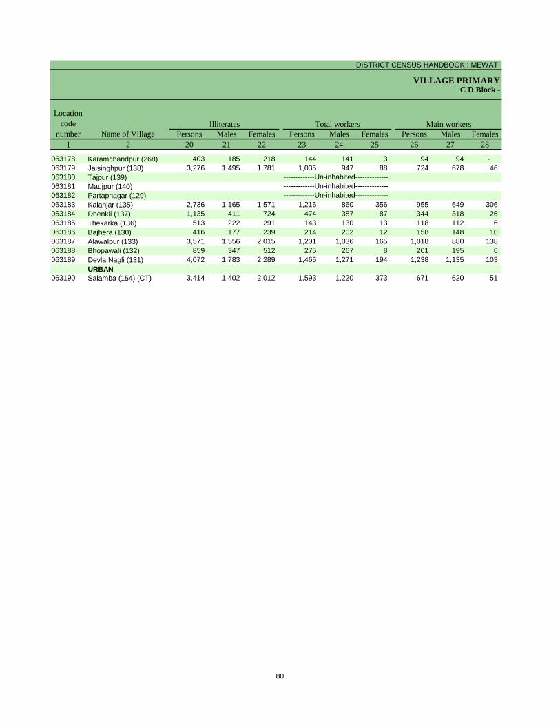
DISTRICT CENSUS HANDBOOK : MEWAT
VILLAGE PRIMARYC D Block -
Persons Males Females Persons Males Females Persons Males Females1 2 20 21 22 23 24 25 26 27 28
Illiterates Total workers Main workersName of Village
Location code
number
063178 Karamchandpur (268) 403 185 218 144 141 3 94 94 - 063179 Jaisinghpur (138) 3,276 1,495 1,781 1,035 947 88 724 678 46 063180 Tajpur (139)063181 Maujpur (140)063182 Partapnagar (129)063183 Kalanjar (135) 2,736 1,165 1,571 1,216 860 356 955 649 306 063184 Dhenkli (137) 1,135 411 724 474 387 87 344 318 26 063185 Thekarka (136) 513 222 291 143 130 13 118 112 6 063186 Bajhera (130) 416 177 239 214 202 12 158 148 10 063187 Alawalpur (133) 3,571 1,556 2,015 1,201 1,036 165 1,018 880 138 063188 Bhopawali (132) 859 347 512 275 267 8 201 195 6 063189 Devla Nagli (131) 4,072 1,783 2,289 1,465 1,271 194 1,238 1,135 103
URBAN063190 Salamba (154) (CT) 3,414 1,402 2,012 1,593 1,220 373 671 620 51
-------------Un-inhabited--------------
-------------Un-inhabited---------------------------Un-inhabited--------------
80
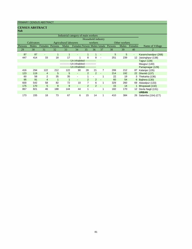
PRIMARY CENSUS ABSTRACT
CENSUS ABSTRACTNuh
Persons Males Females Persons Males Females PersonsMalesFemales Persons Males Females29 30 31 32 33 34 35 36 37 38 39 40 2
CultivatorsName of Village
Household industry workersAgricultural labourers
Industrial category of main workers
Other workers
87 87 - 1 1 - 1 1 - 5 5 - Karamchandpur (268)447 414 33 18 17 1 8 8 - 251 239 12 Jaisinghpur (138)
Tajpur (139)Maujpur (140)Partapnagar (129)
416 294 122 212 122 90 28 21 7 299 212 87 Kalanjar (135)123 119 4 5 5 - 2 2 - 214 192 22 Dhenkli (137)60 58 2 35 35 - 1 - 1 22 19 3 Thekarka (136)95 91 4 1 1 - 2 2 - 60 54 6 Bajhera (130)
600 542 58 82 72 10 7 6 1 329 260 69 Alawalpur (133)175 170 5 9 9 - 2 2 - 15 14 1 Bhopawali (132)867 821 46 188 144 44 1 - 1 182 170 12 Devla Nagli (131)
URBAN173 155 18 73 67 6 15 14 1 410 384 26 Salamba (154) (CT)
-------------Un-inhabited--------------
-------------Un-inhabited---------------------------Un-inhabited--------------
81
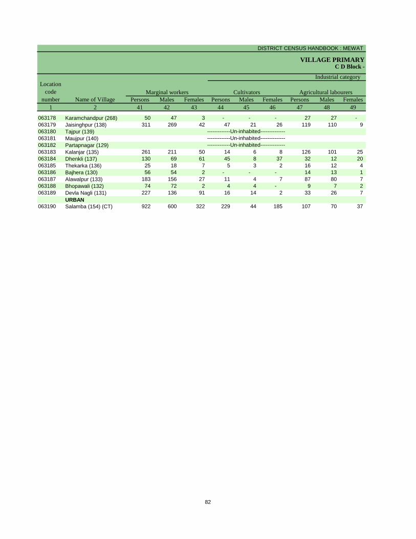
DISTRICT CENSUS HANDBOOK : MEWAT
VILLAGE PRIMARYC D Block -
Persons Males Females Persons Males Females Persons Males Females1 2 41 42 43 44 45 46 47 48 49
Location code
number Name of VillageMarginal workers Cultivators Agricultural labourers
Industrial category
063178 Karamchandpur (268) 50 47 3 - - - 27 27 - 063179 Jaisinghpur (138) 311 269 42 47 21 26 119 110 9 063180 Tajpur (139)063181 Maujpur (140)063182 Partapnagar (129)063183 Kalanjar (135) 261 211 50 14 6 8 126 101 25 063184 Dhenkli (137) 130 69 61 45 8 37 32 12 20 063185 Thekarka (136) 25 18 7 5 3 2 16 12 4 063186 Bajhera (130) 56 54 2 - - - 14 13 1 063187 Alawalpur (133) 183 156 27 11 4 7 87 80 7 063188 Bhopawali (132) 74 72 2 4 4 - 9 7 2 063189 Devla Nagli (131) 227 136 91 16 14 2 33 26 7
URBAN063190 Salamba (154) (CT) 922 600 322 229 44 185 107 70 37
-------------Un-inhabited--------------
-------------Un-inhabited---------------------------Un-inhabited--------------
82
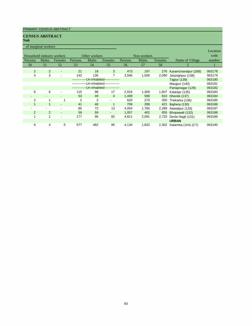
PRIMARY CENSUS ABSTRACT
CENSUS ABSTRACTNuh
Persons Males Females Persons Males Females Persons Males Females50 51 52 53 54 55 56 57 58 2 1
Non-workers
of marginal workersLocation
code number
Household industry workersName of Village
Other workers
2 2 - 21 18 3 473 197 276 Karamchandpur (268) 0631783 3 - 142 135 7 3,596 1,506 2,090 Jaisinghpur (138) 063179
Tajpur (139) 063180Maujpur (140) 063181Partapnagar (129) 063182
6 6 - 115 98 17 2,916 1,309 1,607 Kalanjar (135) 063183- - - 53 49 4 1,409 599 810 Dhenkli (137) 063184
2 1 1 2 2 - 620 270 350 Thekarka (136) 0631851 1 - 41 40 1 709 288 421 Bajhera (130) 063186
- - - 85 72 13 4,054 1,765 2,289 Alawalpur (133) 0631872 2 - 59 59 - 1,057 402 655 Bhopawali (132) 0631881 1 - 177 95 82 4,811 2,091 2,720 Devla Nagli (131) 063189
URBAN9 4 5 577 482 95 4,134 1,832 2,302 Salamba (154) (CT) 063190
-------------Un-inhabited--------------
-------------Un-inhabited---------------------------Un-inhabited--------------
83
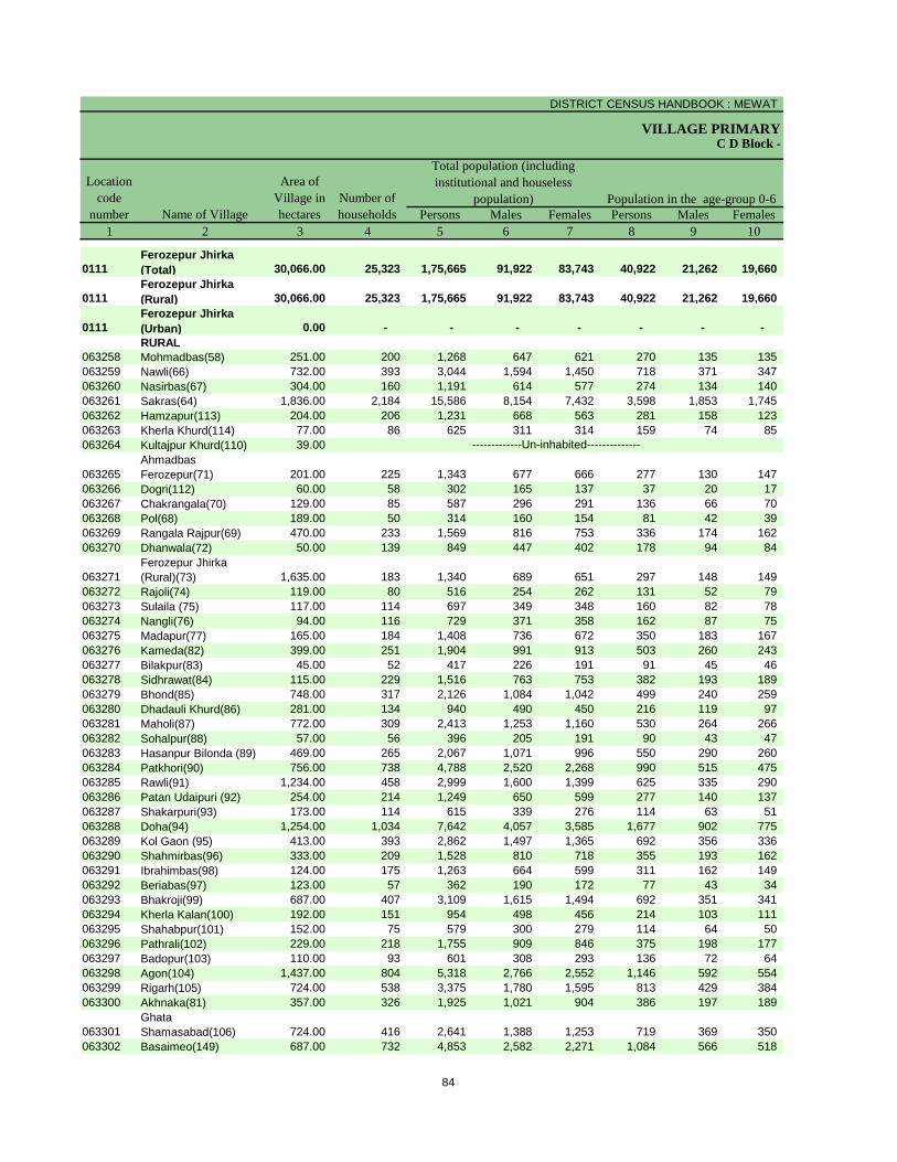
DISTRICT CENSUS HANDBOOK : MEWAT
VILLAGE PRIMARY
Persons Males Females Persons Males Females1 2 3 4 5 6 7 8 9 10
0111Ferozepur Jhirka (Total) 30,066.00 25,323 1,75,665 91,922 83,743 40,922 21,262 19,660
0111Ferozepur Jhirka (Rural) 30,066.00 25,323 1,75,665 91,922 83,743 40,922 21,262 19,660
0111Ferozepur Jhirka (Urban) 0.00 - - - - - - - RURAL
063258 Mohmadbas(58) 251.00 200 1,268 647 621 270 135 135 063259 Nawli(66) 732.00 393 3,044 1,594 1,450 718 371 347 063260 Nasirbas(67) 304.00 160 1,191 614 577 274 134 140 063261 Sakras(64) 1,836.00 2,184 15,586 8,154 7,432 3,598 1,853 1,745 063262 Hamzapur(113) 204.00 206 1,231 668 563 281 158 123 063263 Kherla Khurd(114) 77.00 86 625 311 314 159 74 85 063264 Kultajpur Khurd(110) 39.00
063265Ahmadbas Ferozepur(71) 201.00 225 1,343 677 666 277 130 147
063266 Dogri(112) 60.00 58 302 165 137 37 20 17 063267 Chakrangala(70) 129.00 85 587 296 291 136 66 70 063268 Pol(68) 189.00 50 314 160 154 81 42 39 063269 Rangala Rajpur(69) 470.00 233 1,569 816 753 336 174 162 063270 Dhanwala(72) 50.00 139 849 447 402 178 94 84
063271Ferozepur Jhirka (Rural)(73) 1,635.00 183 1,340 689 651 297 148 149
063272 Rajoli(74) 119.00 80 516 254 262 131 52 79 063273 Sulaila (75) 117.00 114 697 349 348 160 82 78 063274 Nangli(76) 94.00 116 729 371 358 162 87 75 063275 Madapur(77) 165.00 184 1,408 736 672 350 183 167 063276 Kameda(82) 399.00 251 1,904 991 913 503 260 243 063277 Bilakpur(83) 45.00 52 417 226 191 91 45 46 063278 Sidhrawat(84) 115.00 229 1,516 763 753 382 193 189 063279 Bhond(85) 748.00 317 2,126 1,084 1,042 499 240 259 063280 Dhadauli Khurd(86) 281.00 134 940 490 450 216 119 97 063281 Maholi(87) 772.00 309 2,413 1,253 1,160 530 264 266 063282 Sohalpur(88) 57.00 56 396 205 191 90 43 47 063283 Hasanpur Bilonda (89) 469.00 265 2,067 1,071 996 550 290 260 063284 Patkhori(90) 756.00 738 4,788 2,520 2,268 990 515 475 063285 Rawli(91) 1,234.00 458 2,999 1,600 1,399 625 335 290 063286 Patan Udaipuri (92) 254.00 214 1,249 650 599 277 140 137 063287 Shakarpuri(93) 173.00 114 615 339 276 114 63 51 063288 Doha(94) 1,254.00 1,034 7,642 4,057 3,585 1,677 902 775 063289 Kol Gaon (95) 413.00 393 2,862 1,497 1,365 692 356 336 063290 Shahmirbas(96) 333.00 209 1,528 810 718 355 193 162 063291 Ibrahimbas(98) 124.00 175 1,263 664 599 311 162 149 063292 Beriabas(97) 123.00 57 362 190 172 77 43 34 063293 Bhakroji(99) 687.00 407 3,109 1,615 1,494 692 351 341 063294 Kherla Kalan(100) 192.00 151 954 498 456 214 103 111 063295 Shahabpur(101) 152.00 75 579 300 279 114 64 50 063296 Pathrali(102) 229.00 218 1,755 909 846 375 198 177 063297 Badopur(103) 110.00 93 601 308 293 136 72 64 063298 Agon(104) 1,437.00 804 5,318 2,766 2,552 1,146 592 554 063299 Rigarh(105) 724.00 538 3,375 1,780 1,595 813 429 384 063300 Akhnaka(81) 357.00 326 1,925 1,021 904 386 197 189
063301Ghata Shamasabad(106) 724.00 416 2,641 1,388 1,253 719 369 350
063302 Basaimeo(149) 687.00 732 4,853 2,582 2,271 1,084 566 518
C D Block -
Population in the age-group 0-6Name of Village
Location code
number
Total population (including institutional and houseless
population)Area of
Village in hectares
Number of households
-------------Un-inhabited--------------
84
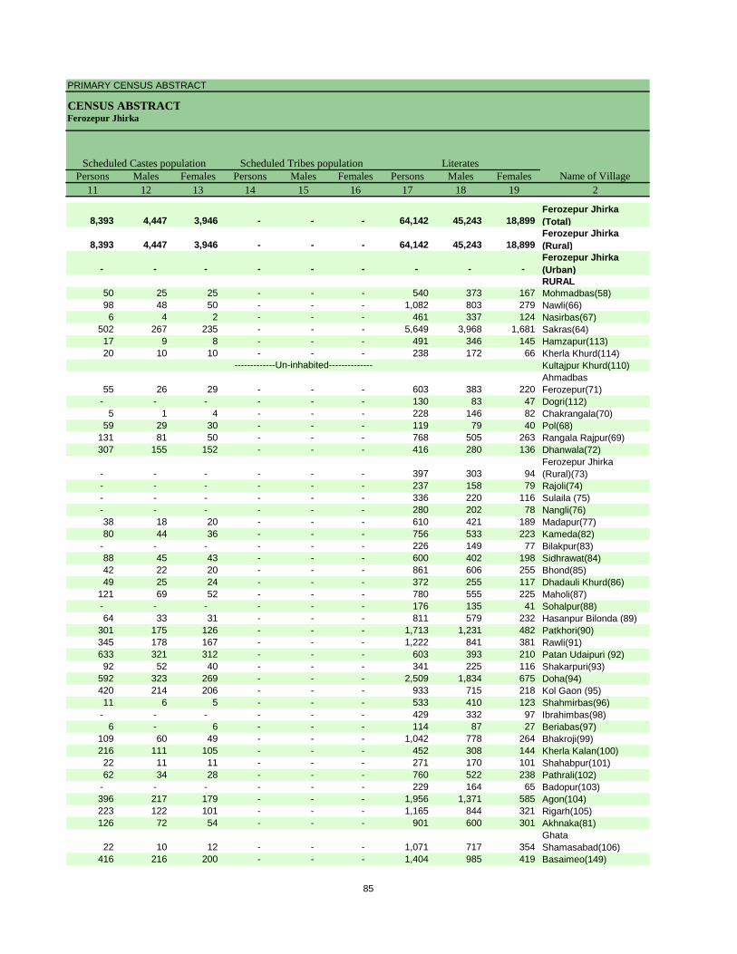
PRIMARY CENSUS ABSTRACT
CENSUS ABSTRACTFerozepur Jhirka
Persons Males Females Persons Males Females Persons Males Females11 12 13 14 15 16 17 18 19 2
8,393 4,447 3,946 - - - 64,142 45,243 18,899 Ferozepur Jhirka (Total)
8,393 4,447 3,946 - - - 64,142 45,243 18,899 Ferozepur Jhirka (Rural)
- - - - - - - - - Ferozepur Jhirka (Urban)RURAL
50 25 25 - - - 540 373 167 Mohmadbas(58)98 48 50 - - - 1,082 803 279 Nawli(66)6 4 2 - - - 461 337 124 Nasirbas(67)
502 267 235 - - - 5,649 3,968 1,681 Sakras(64)17 9 8 - - - 491 346 145 Hamzapur(113)20 10 10 - - - 238 172 66 Kherla Khurd(114)
Kultajpur Khurd(110)
55 26 29 - - - 603 383 220 Ahmadbas Ferozepur(71)
- - - - - - 130 83 47 Dogri(112)5 1 4 - - - 228 146 82 Chakrangala(70)
59 29 30 - - - 119 79 40 Pol(68)131 81 50 - - - 768 505 263 Rangala Rajpur(69)307 155 152 - - - 416 280 136 Dhanwala(72)
- - - - - - 397 303 94 Ferozepur Jhirka (Rural)(73)
- - - - - - 237 158 79 Rajoli(74)- - - - - - 336 220 116 Sulaila (75)- - - - - - 280 202 78 Nangli(76)38 18 20 - - - 610 421 189 Madapur(77)80 44 36 - - - 756 533 223 Kameda(82)
- - - - - - 226 149 77 Bilakpur(83)88 45 43 - - - 600 402 198 Sidhrawat(84)42 22 20 - - - 861 606 255 Bhond(85)49 25 24 - - - 372 255 117 Dhadauli Khurd(86)
121 69 52 - - - 780 555 225 Maholi(87)- - - - - - 176 135 41 Sohalpur(88)64 33 31 - - - 811 579 232 Hasanpur Bilonda (89)
301 175 126 - - - 1,713 1,231 482 Patkhori(90)345 178 167 - - - 1,222 841 381 Rawli(91)633 321 312 - - - 603 393 210 Patan Udaipuri (92)92 52 40 - - - 341 225 116 Shakarpuri(93)
592 323 269 - - - 2,509 1,834 675 Doha(94)420 214 206 - - - 933 715 218 Kol Gaon (95)11 6 5 - - - 533 410 123 Shahmirbas(96)
- - - - - - 429 332 97 Ibrahimbas(98)6 - 6 - - - 114 87 27 Beriabas(97)
109 60 49 - - - 1,042 778 264 Bhakroji(99)216 111 105 - - - 452 308 144 Kherla Kalan(100)22 11 11 - - - 271 170 101 Shahabpur(101)62 34 28 - - - 760 522 238 Pathrali(102)
- - - - - - 229 164 65 Badopur(103)396 217 179 - - - 1,956 1,371 585 Agon(104)223 122 101 - - - 1,165 844 321 Rigarh(105)126 72 54 - - - 901 600 301 Akhnaka(81)
22 10 12 - - - 1,071 717 354 Ghata Shamasabad(106)
416 216 200 - - - 1,404 985 419 Basaimeo(149)
Scheduled Castes population Scheduled Tribes populationName of Village
Literates
-------------Un-inhabited--------------
85
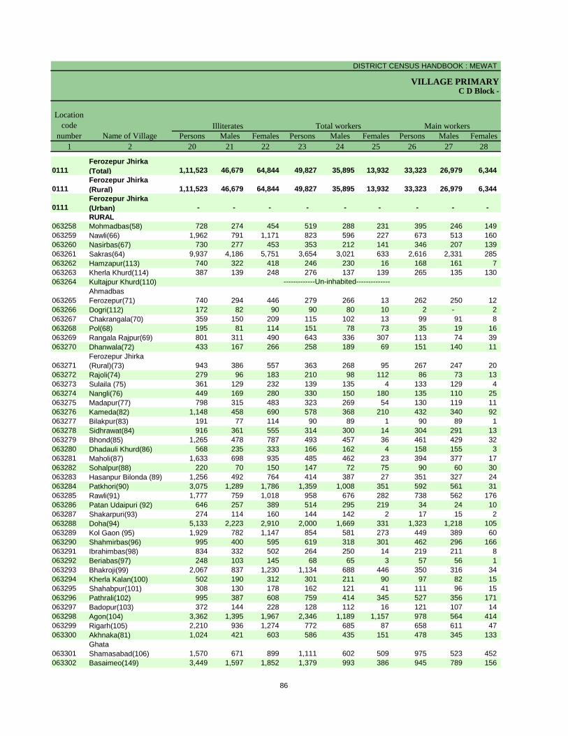
DISTRICT CENSUS HANDBOOK : MEWAT
VILLAGE PRIMARYC D Block -
Persons Males Females Persons Males Females Persons Males Females1 2 20 21 22 23 24 25 26 27 28
0111Ferozepur Jhirka (Total) 1,11,523 46,679 64,844 49,827 35,895 13,932 33,323 26,979 6,344
0111Ferozepur Jhirka (Rural) 1,11,523 46,679 64,844 49,827 35,895 13,932 33,323 26,979 6,344
0111Ferozepur Jhirka (Urban) - - - - - - - - - RURAL
063258 Mohmadbas(58) 728 274 454 519 288 231 395 246 149 063259 Nawli(66) 1,962 791 1,171 823 596 227 673 513 160 063260 Nasirbas(67) 730 277 453 353 212 141 346 207 139 063261 Sakras(64) 9,937 4,186 5,751 3,654 3,021 633 2,616 2,331 285 063262 Hamzapur(113) 740 322 418 246 230 16 168 161 7 063263 Kherla Khurd(114) 387 139 248 276 137 139 265 135 130 063264 Kultajpur Khurd(110)
063265Ahmadbas Ferozepur(71) 740 294 446 279 266 13 262 250 12
063266 Dogri(112) 172 82 90 90 80 10 2 - 2 063267 Chakrangala(70) 359 150 209 115 102 13 99 91 8 063268 Pol(68) 195 81 114 151 78 73 35 19 16 063269 Rangala Rajpur(69) 801 311 490 643 336 307 113 74 39 063270 Dhanwala(72) 433 167 266 258 189 69 151 140 11
063271Ferozepur Jhirka (Rural)(73) 943 386 557 363 268 95 267 247 20
063272 Rajoli(74) 279 96 183 210 98 112 86 73 13 063273 Sulaila (75) 361 129 232 139 135 4 133 129 4 063274 Nangli(76) 449 169 280 330 150 180 135 110 25 063275 Madapur(77) 798 315 483 323 269 54 130 119 11 063276 Kameda(82) 1,148 458 690 578 368 210 432 340 92 063277 Bilakpur(83) 191 77 114 90 89 1 90 89 1 063278 Sidhrawat(84) 916 361 555 314 300 14 304 291 13 063279 Bhond(85) 1,265 478 787 493 457 36 461 429 32 063280 Dhadauli Khurd(86) 568 235 333 166 162 4 158 155 3 063281 Maholi(87) 1,633 698 935 485 462 23 394 377 17 063282 Sohalpur(88) 220 70 150 147 72 75 90 60 30 063283 Hasanpur Bilonda (89) 1,256 492 764 414 387 27 351 327 24 063284 Patkhori(90) 3,075 1,289 1,786 1,359 1,008 351 592 561 31 063285 Rawli(91) 1,777 759 1,018 958 676 282 738 562 176 063286 Patan Udaipuri (92) 646 257 389 514 295 219 34 24 10 063287 Shakarpuri(93) 274 114 160 144 142 2 17 15 2 063288 Doha(94) 5,133 2,223 2,910 2,000 1,669 331 1,323 1,218 105 063289 Kol Gaon (95) 1,929 782 1,147 854 581 273 449 389 60 063290 Shahmirbas(96) 995 400 595 619 318 301 462 296 166 063291 Ibrahimbas(98) 834 332 502 264 250 14 219 211 8 063292 Beriabas(97) 248 103 145 68 65 3 57 56 1 063293 Bhakroji(99) 2,067 837 1,230 1,134 688 446 350 316 34 063294 Kherla Kalan(100) 502 190 312 301 211 90 97 82 15 063295 Shahabpur(101) 308 130 178 162 121 41 111 96 15 063296 Pathrali(102) 995 387 608 759 414 345 527 356 171 063297 Badopur(103) 372 144 228 128 112 16 121 107 14 063298 Agon(104) 3,362 1,395 1,967 2,346 1,189 1,157 978 564 414 063299 Rigarh(105) 2,210 936 1,274 772 685 87 658 611 47 063300 Akhnaka(81) 1,024 421 603 586 435 151 478 345 133
063301Ghata Shamasabad(106) 1,570 671 899 1,111 602 509 975 523 452
063302 Basaimeo(149) 3,449 1,597 1,852 1,379 993 386 945 789 156
Illiterates Total workers Main workersName of Village
Location code
number
-------------Un-inhabited--------------
86
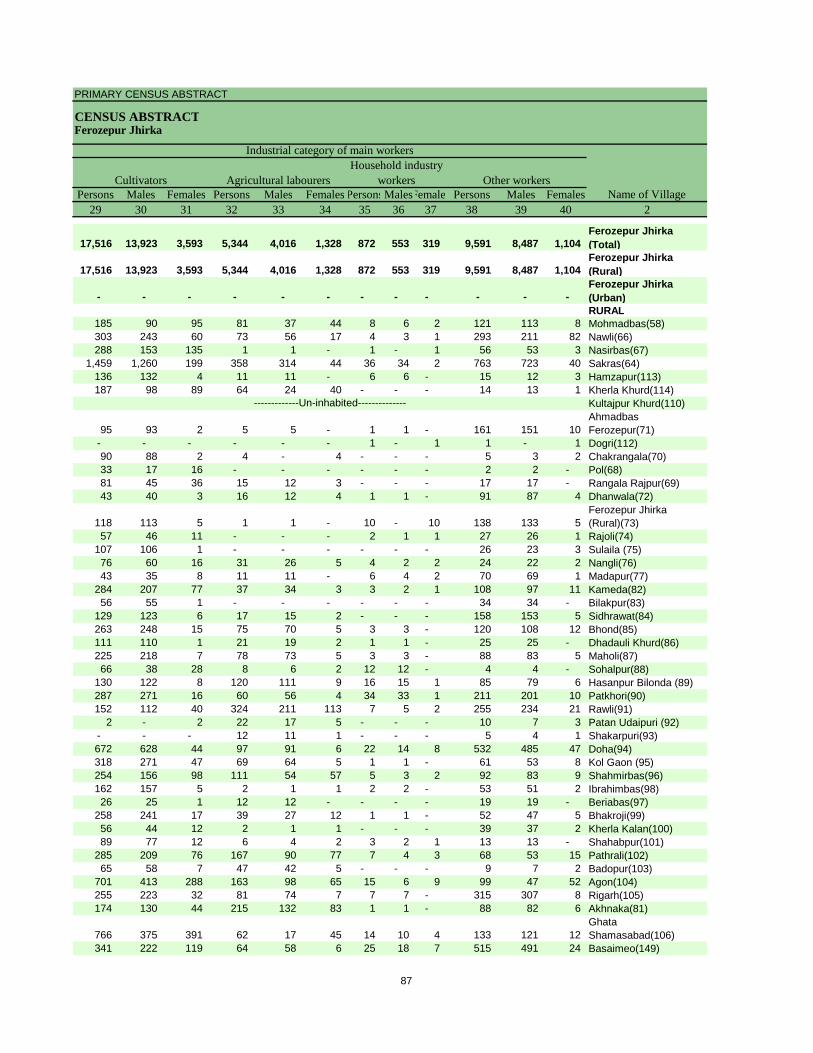
PRIMARY CENSUS ABSTRACT
CENSUS ABSTRACTFerozepur Jhirka
Persons Males Females Persons Males Females PersonsMalesFemales Persons Males Females29 30 31 32 33 34 35 36 37 38 39 40 2
17,516 13,923 3,593 5,344 4,016 1,328 872 553 319 9,591 8,487 1,104 Ferozepur Jhirka (Total)
17,516 13,923 3,593 5,344 4,016 1,328 872 553 319 9,591 8,487 1,104 Ferozepur Jhirka (Rural)
- - - - - - - - - - - - Ferozepur Jhirka (Urban)RURAL
185 90 95 81 37 44 8 6 2 121 113 8 Mohmadbas(58)303 243 60 73 56 17 4 3 1 293 211 82 Nawli(66)288 153 135 1 1 - 1 - 1 56 53 3 Nasirbas(67)
1,459 1,260 199 358 314 44 36 34 2 763 723 40 Sakras(64)136 132 4 11 11 - 6 6 - 15 12 3 Hamzapur(113)187 98 89 64 24 40 - - - 14 13 1 Kherla Khurd(114)
Kultajpur Khurd(110)
95 93 2 5 5 - 1 1 - 161 151 10 Ahmadbas Ferozepur(71)
- - - - - - 1 - 1 1 - 1 Dogri(112)90 88 2 4 - 4 - - - 5 3 2 Chakrangala(70)33 17 16 - - - - - - 2 2 - Pol(68)81 45 36 15 12 3 - - - 17 17 - Rangala Rajpur(69)43 40 3 16 12 4 1 1 - 91 87 4 Dhanwala(72)
118 113 5 1 1 - 10 - 10 138 133 5 Ferozepur Jhirka (Rural)(73)
57 46 11 - - - 2 1 1 27 26 1 Rajoli(74)107 106 1 - - - - - - 26 23 3 Sulaila (75)76 60 16 31 26 5 4 2 2 24 22 2 Nangli(76)43 35 8 11 11 - 6 4 2 70 69 1 Madapur(77)
284 207 77 37 34 3 3 2 1 108 97 11 Kameda(82)56 55 1 - - - - - - 34 34 - Bilakpur(83)
129 123 6 17 15 2 - - - 158 153 5 Sidhrawat(84)263 248 15 75 70 5 3 3 - 120 108 12 Bhond(85)111 110 1 21 19 2 1 1 - 25 25 - Dhadauli Khurd(86)225 218 7 78 73 5 3 3 - 88 83 5 Maholi(87)66 38 28 8 6 2 12 12 - 4 4 - Sohalpur(88)
130 122 8 120 111 9 16 15 1 85 79 6 Hasanpur Bilonda (89)287 271 16 60 56 4 34 33 1 211 201 10 Patkhori(90)152 112 40 324 211 113 7 5 2 255 234 21 Rawli(91)
2 - 2 22 17 5 - - - 10 7 3 Patan Udaipuri (92)- - - 12 11 1 - - - 5 4 1 Shakarpuri(93)672 628 44 97 91 6 22 14 8 532 485 47 Doha(94)318 271 47 69 64 5 1 1 - 61 53 8 Kol Gaon (95)254 156 98 111 54 57 5 3 2 92 83 9 Shahmirbas(96)162 157 5 2 1 1 2 2 - 53 51 2 Ibrahimbas(98)26 25 1 12 12 - - - - 19 19 - Beriabas(97)
258 241 17 39 27 12 1 1 - 52 47 5 Bhakroji(99)56 44 12 2 1 1 - - - 39 37 2 Kherla Kalan(100)89 77 12 6 4 2 3 2 1 13 13 - Shahabpur(101)
285 209 76 167 90 77 7 4 3 68 53 15 Pathrali(102)65 58 7 47 42 5 - - - 9 7 2 Badopur(103)
701 413 288 163 98 65 15 6 9 99 47 52 Agon(104)255 223 32 81 74 7 7 7 - 315 307 8 Rigarh(105)174 130 44 215 132 83 1 1 - 88 82 6 Akhnaka(81)
766 375 391 62 17 45 14 10 4 133 121 12 Ghata Shamasabad(106)
341 222 119 64 58 6 25 18 7 515 491 24 Basaimeo(149)
CultivatorsName of Village
Household industry workersAgricultural labourers
Industrial category of main workers
Other workers
-------------Un-inhabited--------------
87
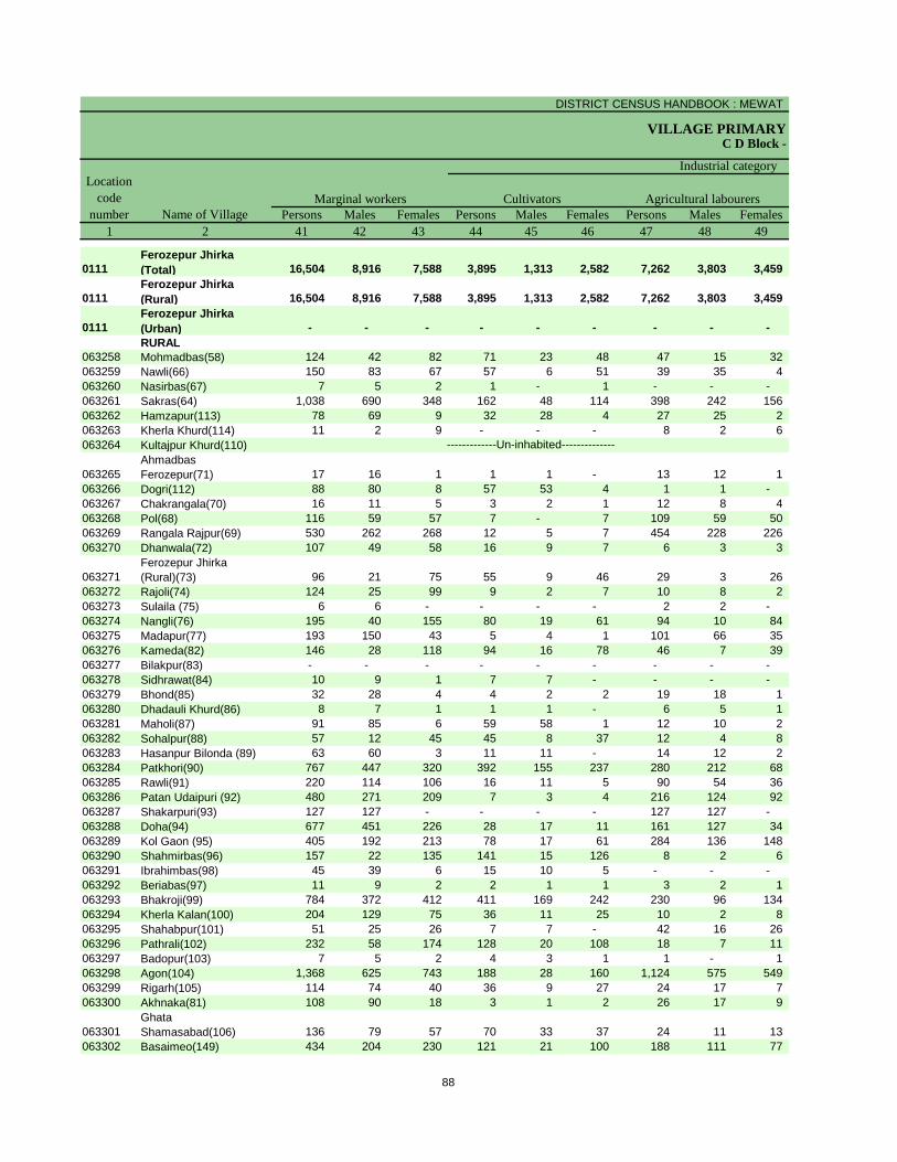
DISTRICT CENSUS HANDBOOK : MEWAT
VILLAGE PRIMARYC D Block -
Persons Males Females Persons Males Females Persons Males Females1 2 41 42 43 44 45 46 47 48 49
0111Ferozepur Jhirka (Total) 16,504 8,916 7,588 3,895 1,313 2,582 7,262 3,803 3,459
0111Ferozepur Jhirka (Rural) 16,504 8,916 7,588 3,895 1,313 2,582 7,262 3,803 3,459
0111Ferozepur Jhirka (Urban) - - - - - - - - - RURAL
063258 Mohmadbas(58) 124 42 82 71 23 48 47 15 32 063259 Nawli(66) 150 83 67 57 6 51 39 35 4 063260 Nasirbas(67) 7 5 2 1 - 1 - - - 063261 Sakras(64) 1,038 690 348 162 48 114 398 242 156 063262 Hamzapur(113) 78 69 9 32 28 4 27 25 2 063263 Kherla Khurd(114) 11 2 9 - - - 8 2 6 063264 Kultajpur Khurd(110)
063265Ahmadbas Ferozepur(71) 17 16 1 1 1 - 13 12 1
063266 Dogri(112) 88 80 8 57 53 4 1 1 - 063267 Chakrangala(70) 16 11 5 3 2 1 12 8 4 063268 Pol(68) 116 59 57 7 - 7 109 59 50 063269 Rangala Rajpur(69) 530 262 268 12 5 7 454 228 226 063270 Dhanwala(72) 107 49 58 16 9 7 6 3 3
063271Ferozepur Jhirka (Rural)(73) 96 21 75 55 9 46 29 3 26
063272 Rajoli(74) 124 25 99 9 2 7 10 8 2 063273 Sulaila (75) 6 6 - - - - 2 2 - 063274 Nangli(76) 195 40 155 80 19 61 94 10 84 063275 Madapur(77) 193 150 43 5 4 1 101 66 35 063276 Kameda(82) 146 28 118 94 16 78 46 7 39 063277 Bilakpur(83) - - - - - - - - - 063278 Sidhrawat(84) 10 9 1 7 7 - - - - 063279 Bhond(85) 32 28 4 4 2 2 19 18 1 063280 Dhadauli Khurd(86) 8 7 1 1 1 - 6 5 1 063281 Maholi(87) 91 85 6 59 58 1 12 10 2 063282 Sohalpur(88) 57 12 45 45 8 37 12 4 8 063283 Hasanpur Bilonda (89) 63 60 3 11 11 - 14 12 2 063284 Patkhori(90) 767 447 320 392 155 237 280 212 68 063285 Rawli(91) 220 114 106 16 11 5 90 54 36 063286 Patan Udaipuri (92) 480 271 209 7 3 4 216 124 92 063287 Shakarpuri(93) 127 127 - - - - 127 127 - 063288 Doha(94) 677 451 226 28 17 11 161 127 34 063289 Kol Gaon (95) 405 192 213 78 17 61 284 136 148 063290 Shahmirbas(96) 157 22 135 141 15 126 8 2 6 063291 Ibrahimbas(98) 45 39 6 15 10 5 - - - 063292 Beriabas(97) 11 9 2 2 1 1 3 2 1 063293 Bhakroji(99) 784 372 412 411 169 242 230 96 134 063294 Kherla Kalan(100) 204 129 75 36 11 25 10 2 8 063295 Shahabpur(101) 51 25 26 7 7 - 42 16 26 063296 Pathrali(102) 232 58 174 128 20 108 18 7 11 063297 Badopur(103) 7 5 2 4 3 1 1 - 1 063298 Agon(104) 1,368 625 743 188 28 160 1,124 575 549 063299 Rigarh(105) 114 74 40 36 9 27 24 17 7 063300 Akhnaka(81) 108 90 18 3 1 2 26 17 9
063301Ghata Shamasabad(106) 136 79 57 70 33 37 24 11 13
063302 Basaimeo(149) 434 204 230 121 21 100 188 111 77
Location code
number Name of VillageMarginal workers Cultivators Agricultural labourers
Industrial category
-------------Un-inhabited--------------
88
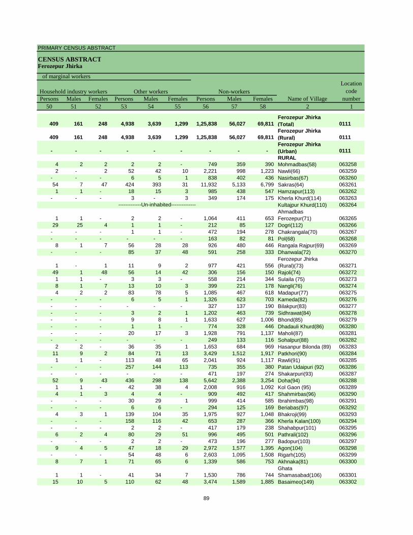
PRIMARY CENSUS ABSTRACT
CENSUS ABSTRACTFerozepur Jhirka
Persons Males Females Persons Males Females Persons Males Females50 51 52 53 54 55 56 57 58 2 1
409 161 248 4,938 3,639 1,299 1,25,838 56,027 69,811 Ferozepur Jhirka (Total) 0111
409 161 248 4,938 3,639 1,299 1,25,838 56,027 69,811 Ferozepur Jhirka (Rural) 0111
- - - - - - - - - Ferozepur Jhirka (Urban) 0111RURAL
4 2 2 2 2 - 749 359 390 Mohmadbas(58) 0632582 - 2 52 42 10 2,221 998 1,223 Nawli(66) 063259
- - - 6 5 1 838 402 436 Nasirbas(67) 06326054 7 47 424 393 31 11,932 5,133 6,799 Sakras(64) 0632611 1 - 18 15 3 985 438 547 Hamzapur(113) 063262
- - - 3 - 3 349 174 175 Kherla Khurd(114) 063263Kultajpur Khurd(110) 063264
1 1 - 2 2 - 1,064 411 653 Ahmadbas Ferozepur(71) 063265
29 25 4 1 1 - 212 85 127 Dogri(112) 063266- - - 1 1 - 472 194 278 Chakrangala(70) 063267- - - - - - 163 82 81 Pol(68) 063268
8 1 7 56 28 28 926 480 446 Rangala Rajpur(69) 063269- - - 85 37 48 591 258 333 Dhanwala(72) 063270
1 - 1 11 9 2 977 421 556 Ferozepur Jhirka (Rural)(73) 063271
49 1 48 56 14 42 306 156 150 Rajoli(74) 0632721 1 - 3 3 - 558 214 344 Sulaila (75) 0632738 1 7 13 10 3 399 221 178 Nangli(76) 0632744 2 2 83 78 5 1,085 467 618 Madapur(77) 063275
- - - 6 5 1 1,326 623 703 Kameda(82) 063276- - - - - - 327 137 190 Bilakpur(83) 063277- - - 3 2 1 1,202 463 739 Sidhrawat(84) 063278- - - 9 8 1 1,633 627 1,006 Bhond(85) 063279- - - 1 1 - 774 328 446 Dhadauli Khurd(86) 063280- - - 20 17 3 1,928 791 1,137 Maholi(87) 063281- - - - - - 249 133 116 Sohalpur(88) 063282
2 2 - 36 35 1 1,653 684 969 Hasanpur Bilonda (89) 06328311 9 2 84 71 13 3,429 1,512 1,917 Patkhori(90) 0632841 1 - 113 48 65 2,041 924 1,117 Rawli(91) 063285
- - - 257 144 113 735 355 380 Patan Udaipuri (92) 063286- - - - - - 471 197 274 Shakarpuri(93) 06328752 9 43 436 298 138 5,642 2,388 3,254 Doha(94) 0632881 1 - 42 38 4 2,008 916 1,092 Kol Gaon (95) 0632894 1 3 4 4 - 909 492 417 Shahmirbas(96) 063290
- - - 30 29 1 999 414 585 Ibrahimbas(98) 063291- - - 6 6 - 294 125 169 Beriabas(97) 063292
4 3 1 139 104 35 1,975 927 1,048 Bhakroji(99) 063293- - - 158 116 42 653 287 366 Kherla Kalan(100) 063294- - - 2 2 - 417 179 238 Shahabpur(101) 063295
6 2 4 80 29 51 996 495 501 Pathrali(102) 063296- - - 2 2 - 473 196 277 Badopur(103) 063297
9 4 5 47 18 29 2,972 1,577 1,395 Agon(104) 063298- - - 54 48 6 2,603 1,095 1,508 Rigarh(105) 063299
8 7 1 71 65 6 1,339 586 753 Akhnaka(81) 063300
1 1 - 41 34 7 1,530 786 744 Ghata Shamasabad(106) 063301
15 10 5 110 62 48 3,474 1,589 1,885 Basaimeo(149) 063302
Non-workers
of marginal workersLocation
code number
Household industry workersName of Village
Other workers
-------------Un-inhabited--------------
89
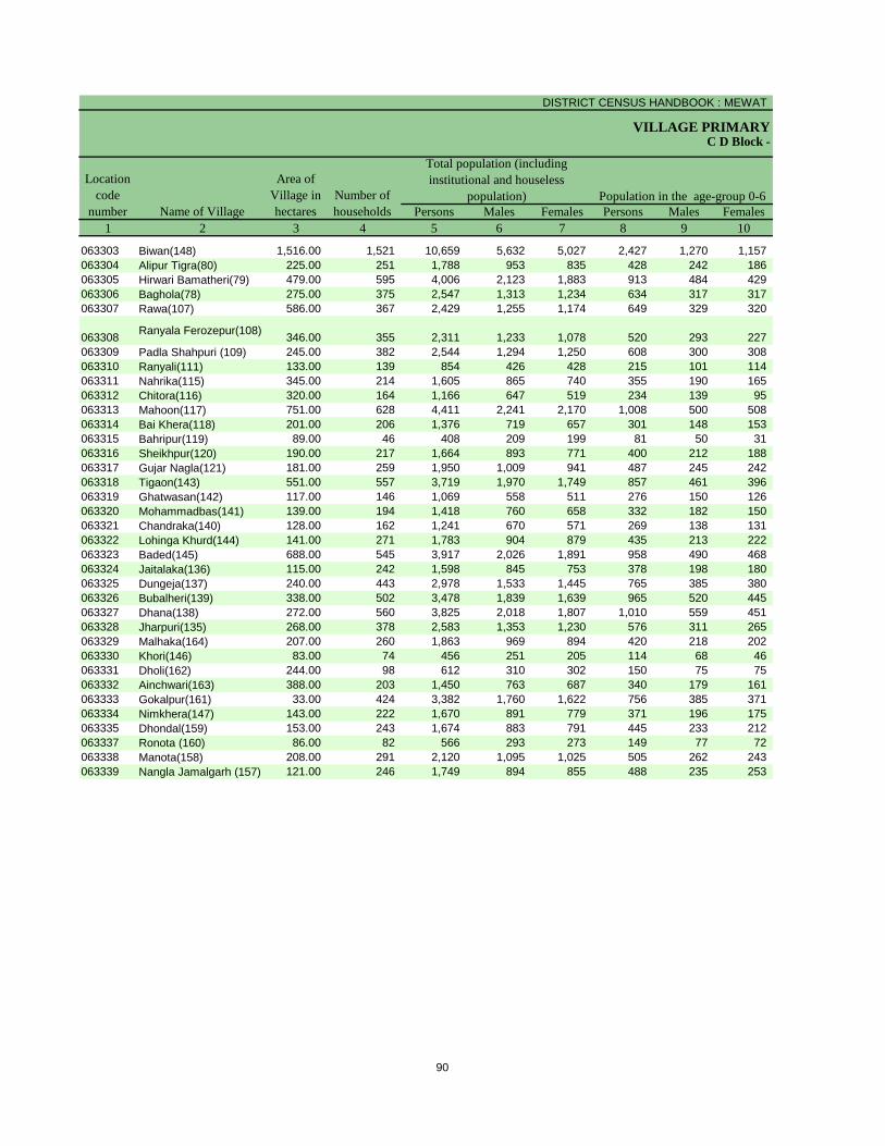
DISTRICT CENSUS HANDBOOK : MEWAT
VILLAGE PRIMARY
Persons Males Females Persons Males Females1 2 3 4 5 6 7 8 9 10
C D Block -
Population in the age-group 0-6Name of Village
Location code
number
Total population (including institutional and houseless
population)Area of
Village in hectares
Number of households
063303 Biwan(148) 1,516.00 1,521 10,659 5,632 5,027 2,427 1,270 1,157 063304 Alipur Tigra(80) 225.00 251 1,788 953 835 428 242 186 063305 Hirwari Bamatheri(79) 479.00 595 4,006 2,123 1,883 913 484 429 063306 Baghola(78) 275.00 375 2,547 1,313 1,234 634 317 317 063307 Rawa(107) 586.00 367 2,429 1,255 1,174 649 329 320
063308 Ranyala Ferozepur(108) 346.00 355 2,311 1,233 1,078 520 293 227 063309 Padla Shahpuri (109) 245.00 382 2,544 1,294 1,250 608 300 308 063310 Ranyali(111) 133.00 139 854 426 428 215 101 114 063311 Nahrika(115) 345.00 214 1,605 865 740 355 190 165 063312 Chitora(116) 320.00 164 1,166 647 519 234 139 95 063313 Mahoon(117) 751.00 628 4,411 2,241 2,170 1,008 500 508 063314 Bai Khera(118) 201.00 206 1,376 719 657 301 148 153 063315 Bahripur(119) 89.00 46 408 209 199 81 50 31 063316 Sheikhpur(120) 190.00 217 1,664 893 771 400 212 188 063317 Gujar Nagla(121) 181.00 259 1,950 1,009 941 487 245 242 063318 Tigaon(143) 551.00 557 3,719 1,970 1,749 857 461 396 063319 Ghatwasan(142) 117.00 146 1,069 558 511 276 150 126 063320 Mohammadbas(141) 139.00 194 1,418 760 658 332 182 150 063321 Chandraka(140) 128.00 162 1,241 670 571 269 138 131 063322 Lohinga Khurd(144) 141.00 271 1,783 904 879 435 213 222 063323 Baded(145) 688.00 545 3,917 2,026 1,891 958 490 468 063324 Jaitalaka(136) 115.00 242 1,598 845 753 378 198 180 063325 Dungeja(137) 240.00 443 2,978 1,533 1,445 765 385 380 063326 Bubalheri(139) 338.00 502 3,478 1,839 1,639 965 520 445 063327 Dhana(138) 272.00 560 3,825 2,018 1,807 1,010 559 451 063328 Jharpuri(135) 268.00 378 2,583 1,353 1,230 576 311 265 063329 Malhaka(164) 207.00 260 1,863 969 894 420 218 202 063330 Khori(146) 83.00 74 456 251 205 114 68 46 063331 Dholi(162) 244.00 98 612 310 302 150 75 75 063332 Ainchwari(163) 388.00 203 1,450 763 687 340 179 161 063333 Gokalpur(161) 33.00 424 3,382 1,760 1,622 756 385 371 063334 Nimkhera(147) 143.00 222 1,670 891 779 371 196 175 063335 Dhondal(159) 153.00 243 1,674 883 791 445 233 212 063337 Ronota (160) 86.00 82 566 293 273 149 77 72 063338 Manota(158) 208.00 291 2,120 1,095 1,025 505 262 243 063339 Nangla Jamalgarh (157) 121.00 246 1,749 894 855 488 235 253
90
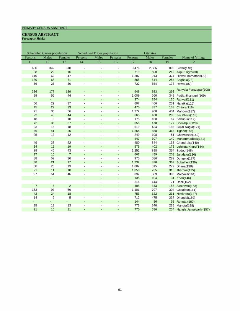
PRIMARY CENSUS ABSTRACT
CENSUS ABSTRACTFerozepur Jhirka
Persons Males Females Persons Males Females Persons Males Females11 12 13 14 15 16 17 18 19 2
Scheduled Castes population Scheduled Tribes populationName of Village
Literates
660 342 318 - - - 3,476 2,586 890 Biwan(148)38 22 16 - - - 719 500 219 Alipur Tigra(80)
110 63 47 - - - 1,287 913 374 Hirwari Bamatheri(79)139 68 71 - - - 868 614 254 Baghola(78)56 26 30 - - - 732 554 178 Rawa(107)
336 177 159 - - - 946 653 293 Ranyala Ferozepur(108)
99 55 44 - - - 1,009 660 349 Padla Shahpuri (109)- - - - - - 374 254 120 Ranyali(111)66 29 37 - - - 697 466 231 Nahrika(115)45 22 23 - - - 470 337 133 Chitora(116)71 35 36 - - - 1,372 968 404 Mahoon(117)92 48 44 - - - 665 460 205 Bai Khera(118)18 8 10 - - - 175 108 67 Bahripur(119)72 35 37 - - - 655 478 177 Sheikhpur(120)33 15 18 - - - 619 434 185 Gujar Nagla(121)66 41 25 - - - 1,254 888 366 Tigaon(143)25 13 12 - - - 249 198 51 Ghatwasan(142)
- - - - - - 447 307 140 Mohammadbas(141)49 27 22 - - - 480 344 136 Chandraka(140)34 15 19 - - - 575 402 173 Lohinga Khurd(144)89 46 43 - - - 1,252 898 354 Baded(145)17 10 7 - - - 667 459 208 Jaitalaka(136)88 52 36 - - - 975 686 289 Dungeja(137)38 21 17 - - - 1,232 870 362 Bubalheri(139)38 25 13 - - - 1,087 815 272 Dhana(138)21 11 10 - - - 1,050 735 315 Jharpuri(135)97 51 46 - - - 892 589 303 Malhaka(164)
- - - - - - 135 104 31 Khori(146)- - - - - - 215 144 71 Dholi(162)
7 5 2 - - - 498 343 155 Ainchwari(163)163 97 66 - - - 1,101 797 304 Gokalpur(161)42 24 18 - - - 753 522 231 Nimkhera(147)14 9 5 - - - 712 475 237 Dhondal(159)
- - - - - - 144 86 58 Ronota (160)25 12 13 - - - 775 540 235 Manota(158)21 10 11 - - - 770 536 234 Nangla Jamalgarh (157)
91
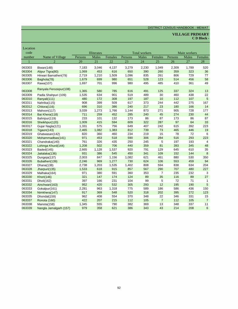
DISTRICT CENSUS HANDBOOK : MEWAT
VILLAGE PRIMARYC D Block -
Persons Males Females Persons Males Females Persons Males Females1 2 20 21 22 23 24 25 26 27 28
Illiterates Total workers Main workersName of Village
Location code
number
063303 Biwan(148) 7,183 3,046 4,137 3,279 2,230 1,049 2,309 1,789 520 063304 Alipur Tigra(80) 1,069 453 616 650 390 260 359 323 36 063305 Hirwari Bamatheri(79) 2,719 1,210 1,509 1,096 835 261 806 729 77 063306 Baghola(78) 1,679 699 980 651 528 123 514 456 58 063307 Rawa(107) 1,697 701 996 980 495 485 410 361 49
063308 Ranyala Ferozepur(108) 1,365 580 785 616 491 125 337 324 13 063309 Padla Shahpuri (109) 1,535 634 901 519 489 30 460 438 22 063310 Ranyali(111) 480 172 308 197 187 10 112 107 5 063311 Nahrika(115) 908 399 509 617 373 244 442 275 167 063312 Chitora(116) 696 310 386 240 217 23 180 166 14 063313 Mahoon(117) 3,039 1,273 1,766 1,144 873 271 905 728 177 063314 Bai Khera(118) 711 259 452 285 240 45 274 230 44 063315 Bahripur(119) 233 101 132 173 86 87 173 86 87 063316 Sheikhpur(120) 1,009 415 594 609 322 287 97 64 33 063317 Gujar Nagla(121) 1,331 575 756 649 407 242 615 392 223 063318 Tigaon(143) 2,465 1,082 1,383 812 739 73 465 446 19 063319 Ghatwasan(142) 820 360 460 234 219 15 78 72 6 063320 Mohammadbas(141) 971 453 518 590 306 284 516 293 223 063321 Chandraka(140) 761 326 435 250 245 5 197 193 4 063322 Lohinga Khurd(144) 1,208 502 706 440 359 81 393 345 48 063323 Baded(145) 2,665 1,128 1,537 920 791 129 645 610 35 063324 Jaitalaka(136) 931 386 545 450 341 109 152 144 8 063325 Dungeja(137) 2,003 847 1,156 1,082 621 461 880 530 350 063326 Bubalheri(139) 2,246 969 1,277 730 624 106 553 459 94 063327 Dhana(138) 2,738 1,203 1,535 1,402 808 594 838 634 204 063328 Jharpuri(135) 1,533 618 915 857 567 290 707 480 227 063329 Malhaka(164) 971 380 591 360 353 7 235 232 3 063330 Khori(146) 321 147 174 124 89 35 116 89 27 063331 Dholi(162) 397 166 231 104 99 5 72 71 1 063332 Ainchwari(163) 952 420 532 305 293 12 195 190 5 063333 Gokalpur(161) 2,281 963 1,318 775 589 186 586 436 150 063334 Nimkhera(147) 917 369 548 520 318 202 395 272 123 063335 Dhondal(159) 962 408 554 370 348 22 346 331 15 063337 Ronota (160) 422 207 215 112 105 7 112 105 7 063338 Manota(158) 1,345 555 790 382 369 13 348 337 11 063339 Nangla Jamalgarh (157) 979 358 621 386 343 43 214 208 6
92
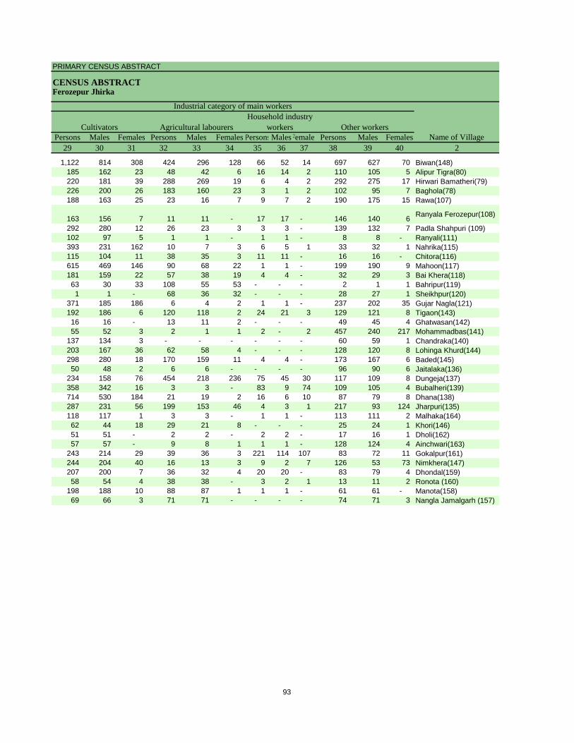
PRIMARY CENSUS ABSTRACT
CENSUS ABSTRACTFerozepur Jhirka
Persons Males Females Persons Males Females PersonsMalesFemales Persons Males Females29 30 31 32 33 34 35 36 37 38 39 40 2
CultivatorsName of Village
Household industry workersAgricultural labourers
Industrial category of main workers
Other workers
1,122 814 308 424 296 128 66 52 14 697 627 70 Biwan(148)185 162 23 48 42 6 16 14 2 110 105 5 Alipur Tigra(80)220 181 39 288 269 19 6 4 2 292 275 17 Hirwari Bamatheri(79)226 200 26 183 160 23 3 1 2 102 95 7 Baghola(78)188 163 25 23 16 7 9 7 2 190 175 15 Rawa(107)
163 156 7 11 11 - 17 17 - 146 140 6 Ranyala Ferozepur(108)
292 280 12 26 23 3 3 3 - 139 132 7 Padla Shahpuri (109)102 97 5 1 1 - 1 1 - 8 8 - Ranyali(111)393 231 162 10 7 3 6 5 1 33 32 1 Nahrika(115)115 104 11 38 35 3 11 11 - 16 16 - Chitora(116)615 469 146 90 68 22 1 1 - 199 190 9 Mahoon(117)181 159 22 57 38 19 4 4 - 32 29 3 Bai Khera(118)63 30 33 108 55 53 - - - 2 1 1 Bahripur(119)1 1 - 68 36 32 - - - 28 27 1 Sheikhpur(120)
371 185 186 6 4 2 1 1 - 237 202 35 Gujar Nagla(121)192 186 6 120 118 2 24 21 3 129 121 8 Tigaon(143)16 16 - 13 11 2 - - - 49 45 4 Ghatwasan(142)55 52 3 2 1 1 2 - 2 457 240 217 Mohammadbas(141)
137 134 3 - - - - - - 60 59 1 Chandraka(140)203 167 36 62 58 4 - - - 128 120 8 Lohinga Khurd(144)298 280 18 170 159 11 4 4 - 173 167 6 Baded(145)50 48 2 6 6 - - - - 96 90 6 Jaitalaka(136)
234 158 76 454 218 236 75 45 30 117 109 8 Dungeja(137)358 342 16 3 3 - 83 9 74 109 105 4 Bubalheri(139)714 530 184 21 19 2 16 6 10 87 79 8 Dhana(138)287 231 56 199 153 46 4 3 1 217 93 124 Jharpuri(135)118 117 1 3 3 - 1 1 - 113 111 2 Malhaka(164)62 44 18 29 21 8 - - - 25 24 1 Khori(146)51 51 - 2 2 - 2 2 - 17 16 1 Dholi(162)57 57 - 9 8 1 1 1 - 128 124 4 Ainchwari(163)
243 214 29 39 36 3 221 114 107 83 72 11 Gokalpur(161)244 204 40 16 13 3 9 2 7 126 53 73 Nimkhera(147)207 200 7 36 32 4 20 20 - 83 79 4 Dhondal(159)58 54 4 38 38 - 3 2 1 13 11 2 Ronota (160)
198 188 10 88 87 1 1 1 - 61 61 - Manota(158)69 66 3 71 71 - - - - 74 71 3 Nangla Jamalgarh (157)
93
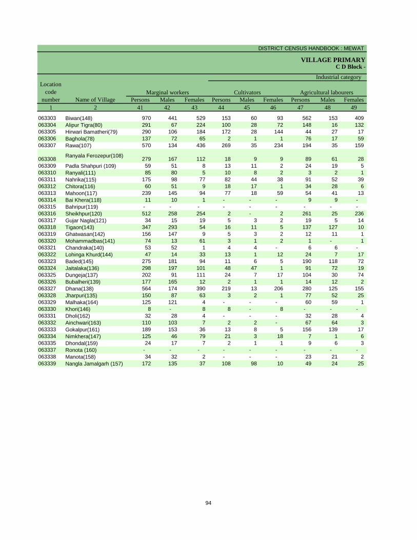
DISTRICT CENSUS HANDBOOK : MEWAT
VILLAGE PRIMARYC D Block -
Persons Males Females Persons Males Females Persons Males Females1 2 41 42 43 44 45 46 47 48 49
Location code
number Name of VillageMarginal workers Cultivators Agricultural labourers
Industrial category
063303 Biwan(148) 970 441 529 153 60 93 562 153 409 063304 Alipur Tigra(80) 291 67 224 100 28 72 148 16 132 063305 Hirwari Bamatheri(79) 290 106 184 172 28 144 44 27 17 063306 Baghola(78) 137 72 65 2 1 1 76 17 59 063307 Rawa(107) 570 134 436 269 35 234 194 35 159
063308 Ranyala Ferozepur(108) 279 167 112 18 9 9 89 61 28 063309 Padla Shahpuri (109) 59 51 8 13 11 2 24 19 5 063310 Ranyali(111) 85 80 5 10 8 2 3 2 1 063311 Nahrika(115) 175 98 77 82 44 38 91 52 39 063312 Chitora(116) 60 51 9 18 17 1 34 28 6 063313 Mahoon(117) 239 145 94 77 18 59 54 41 13 063314 Bai Khera(118) 11 10 1 - - - 9 9 - 063315 Bahripur(119) - - - - - - - - - 063316 Sheikhpur(120) 512 258 254 2 - 2 261 25 236 063317 Gujar Nagla(121) 34 15 19 5 3 2 19 5 14 063318 Tigaon(143) 347 293 54 16 11 5 137 127 10 063319 Ghatwasan(142) 156 147 9 5 3 2 12 11 1 063320 Mohammadbas(141) 74 13 61 3 1 2 1 - 1 063321 Chandraka(140) 53 52 1 4 4 - 6 6 - 063322 Lohinga Khurd(144) 47 14 33 13 1 12 24 7 17 063323 Baded(145) 275 181 94 11 6 5 190 118 72 063324 Jaitalaka(136) 298 197 101 48 47 1 91 72 19 063325 Dungeja(137) 202 91 111 24 7 17 104 30 74 063326 Bubalheri(139) 177 165 12 2 1 1 14 12 2 063327 Dhana(138) 564 174 390 219 13 206 280 125 155 063328 Jharpuri(135) 150 87 63 3 2 1 77 52 25 063329 Malhaka(164) 125 121 4 - - - 60 59 1 063330 Khori(146) 8 - 8 8 - 8 - - - 063331 Dholi(162) 32 28 4 - - - 32 28 4 063332 Ainchwari(163) 110 103 7 2 2 - 67 64 3 063333 Gokalpur(161) 189 153 36 13 8 5 156 139 17 063334 Nimkhera(147) 125 46 79 21 3 18 7 1 6 063335 Dhondal(159) 24 17 7 2 1 1 9 6 3 063337 Ronota (160) - - - - - - - - - 063338 Manota(158) 34 32 2 - - - 23 21 2 063339 Nangla Jamalgarh (157) 172 135 37 108 98 10 49 24 25
94

PRIMARY CENSUS ABSTRACT
CENSUS ABSTRACTFerozepur Jhirka
Persons Males Females Persons Males Females Persons Males Females50 51 52 53 54 55 56 57 58 2 1
Non-workers
of marginal workersLocation
code number
Household industry workersName of Village
Other workers
25 22 3 230 206 24 7,380 3,402 3,978 Biwan(148) 0633031 - 1 42 23 19 1,138 563 575 Alipur Tigra(80) 063304
14 1 13 60 50 10 2,910 1,288 1,622 Hirwari Bamatheri(79) 063305- - - 59 54 5 1,896 785 1,111 Baghola(78) 063306
6 3 3 101 61 40 1,449 760 689 Rawa(107) 063307
5 3 2 167 94 73 1,695 742 953 Ranyala Ferozepur(108) 0633081 1 - 21 20 1 2,025 805 1,220 Padla Shahpuri (109) 0633091 1 - 71 69 2 657 239 418 Ranyali(111) 063310
- - - 2 2 - 988 492 496 Nahrika(115) 0633112 2 - 6 4 2 926 430 496 Chitora(116) 0633121 1 - 107 85 22 3,267 1,368 1,899 Mahoon(117) 063313
- - - 2 1 1 1,091 479 612 Bai Khera(118) 063314- - - - - - 235 123 112 Bahripur(119) 063315- - - 249 233 16 1,055 571 484 Sheikhpur(120) 063316
1 - 1 9 7 2 1,301 602 699 Gujar Nagla(121) 06331712 11 1 182 144 38 2,907 1,231 1,676 Tigaon(143) 063318
- - - 139 133 6 835 339 496 Ghatwasan(142) 0633191 - 1 69 12 57 828 454 374 Mohammadbas(141) 063320
- - - 43 42 1 991 425 566 Chandraka(140) 0633211 - 1 9 6 3 1,343 545 798 Lohinga Khurd(144) 0633221 1 - 73 56 17 2,997 1,235 1,762 Baded(145) 0633231 1 - 158 77 81 1,148 504 644 Jaitalaka(136) 063324
28 12 16 46 42 4 1,896 912 984 Dungeja(137) 0633251 1 - 160 151 9 2,748 1,215 1,533 Bubalheri(139) 0633265 1 4 60 35 25 2,423 1,210 1,213 Dhana(138) 063327
- - - 70 33 37 1,726 786 940 Jharpuri(135) 0633283 2 1 62 60 2 1,503 616 887 Malhaka(164) 063329
- - - - - - 332 162 170 Khori(146) 063330- - - - - - 508 211 297 Dholi(162) 063331
1 - 1 40 37 3 1,145 470 675 Ainchwari(163) 0633329 3 6 11 3 8 2,607 1,171 1,436 Gokalpur(161) 063333
13 3 10 84 39 45 1,150 573 577 Nimkhera(147) 063334- - - 13 10 3 1,304 535 769 Dhondal(159) 063335- - - - - - 454 188 266 Ronota (160) 063337- - - 11 11 - 1,738 726 1,012 Manota(158) 063338- - - 15 13 2 1,363 551 812 Nangla Jamalgarh (157) 063339
95
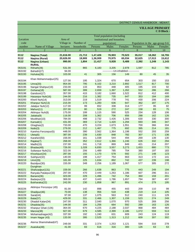
DISTRICT CENSUS HANDBOOK : MEWAT
VILLAGE PRIMARY
Persons Males Females Persons Males Females1 2 3 4 5 6 7 8 9 10
0112 Nagina (Total) 21,616.00 21,713 1,47,426 76,903 70,523 35,017 18,262 16,755 0112 Nagina (Rural) 20,626.00 19,909 1,36,009 70,975 65,034 32,625 17,013 15,612 0112 Nagina (Urban) 990.00 1,804 11,417 5,928 5,489 2,392 1,249 1,143
RURAL063191 Rithath(28) 531.00 865 6,183 3,205 2,978 1,597 812 785 063192 Bahadri(27) 94.00063193 Huhuka(26) 103.00 41 305 156 149 80 45 35
063194 Khan Mohammadpur(25) 127.00 195 1,324 670 654 303 150 153 063195 Umra(20) 954.00 795 6,102 3,210 2,892 1,517 817 700 063196 Nangal Shahpur(19) 233.00 133 853 448 405 195 103 92 063197 Gohana(18) 587.00 399 2,659 1,397 1,262 552 286 266 063198 Gandoori(17) 357.00 415 3,182 1,660 1,522 812 412 400 063199 Hasanpur Nuh(16) 244.00 216 1,382 735 647 353 184 169 063200 Kherli Nuh(14) 313.00 219 1,519 778 741 430 206 224 063201 Khanpur Nuh(13) 215.00 173 1,283 636 647 362 187 175 063202 Jalalpur Nuh(12) 117.00 99 652 338 314 177 95 82 063203 Mahun(11) 207.00 80 519 272 247 158 83 75 063204 Aklimpur Nuh(8) 175.00 199 1,115 590 525 234 128 106 063205 Jaitaka(9) 116.00 208 1,362 706 656 288 162 126 063206 Moolthan(10) 784.00 498 2,732 1,426 1,306 630 330 300 063207 Kansali(1) 431.00 369 2,714 1,420 1,294 693 346 347 063208 Ghaghas(2) 733.00 470 3,224 1,673 1,551 700 366 334 063209 Notki(3) 279.00 212 1,467 775 692 395 214 181 063210 Karehra Ferozepur(5) 448.00 390 2,562 1,364 1,198 552 293 259 063211 Uleta(6) 387.00 239 1,630 848 782 307 171 136 063212 Karaheri(50) 156.00 161 1,038 544 494 269 139 130 063213 Rajaka(7) 268.00 352 2,612 1,366 1,246 626 332 294 063214 Madhi(15) 237.00 241 1,718 869 849 421 214 207 063215 Bhadas(49) 726.00 1,028 6,830 3,557 3,273 1,653 880 773 063216 Sultanpur Nuh(21) 322.00 206 1,489 785 704 380 197 183 063217 Khoshpuri(24) 287.00 155 1,170 578 592 271 148 123 063218 Sukhpuri(32) 140.00 198 1,417 754 663 313 172 141 063219 Umri(29) 181.00 225 1,634 892 742 437 239 198 063220 Bazidpur(30) 155.00 348 2,256 1,189 1,067 577 305 272
063221Dunghran Shahzadpur(131) 159.00 266 1,638 863 775 443 249 194
063222 Ranyala Patakpur(33) 297.00 470 2,449 1,263 1,186 607 296 311 063223 Banarsi(36) 323.00 229 1,496 742 754 360 159 201 063224 Badarpur(23) 369.00 437 3,443 1,786 1,657 794 387 407 063225 Bukharaka(22) 242.00 230 1,858 967 891 474 279 195
063226 Aklimpur Ferozepur (45) 81.00 142 898 455 443 209 110 99 063227 Shadipur(46) 70.00 138 956 518 438 219 114 105 063228 Saral(44) 97.00 137 1,075 563 512 240 111 129 063229 Balai(37) 429.00 331 2,466 1,307 1,159 523 274 249 063230 Dhadoli Kalan(34) 247.00 311 2,040 1,070 970 525 269 256 063231 Dhadola(35) 144.00 184 1,256 664 592 289 163 126 063232 Khanpur Ghati (126) 364.00 670 4,225 2,188 2,037 968 484 484 063233 Marora(38) 927.00 679 4,585 2,399 2,186 1,072 559 513 063234 Mohamadnagar(42) 337.00 192 1,240 631 609 243 124 119 063235 Imam Nagar (43) 133.00 395 2,525 1,313 1,212 609 307 302
063236 Aterna Shamshabad(47) 249.00 331 2,374 1,253 1,121 594 316 278 063237 Asaisika(48) 41.00 83 616 316 300 126 63 63
Name of Village
Location code
number
Total population (including institutional and houseless
population)Area of
Village in hectares
Number of households
C D Block -
Population in the age-group 0-6
-------------Un-inhabited--------------
96
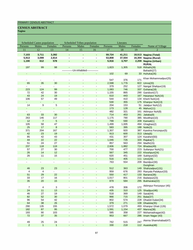
PRIMARY CENSUS ABSTRACT
CENSUS ABSTRACTNagina
Persons Males Females Persons Males Females Persons Males Females11 12 13 14 15 16 17 18 19 2
7,103 3,711 3,392 - - - 59,724 41,211 18,513 Nagina (Total)5,913 3,099 2,814 - - - 53,808 37,504 16,304 Nagina (Rural)1,190 612 578 - - - 5,916 3,707 2,209 Nagina (Urban)
RURAL197 99 98 - - - 1,823 1,305 518 Rithath(28)
Bahadri(27)- - - - - - 102 69 33 Huhuka(26)
- - - - - - 547 376 171 Khan Mohammadpur(25)
65 35 30 - - - 2,598 1,776 822 Umra(20)- - - - - - 379 252 127 Nangal Shahpur(19)223 124 99 - - - 1,083 746 337 Gohana(18)72 42 30 - - - 1,155 865 290 Gandoori(17)43 24 19 - - - 610 443 167 Hasanpur Nuh(16)
106 57 49 - - - 544 410 134 Kherli Nuh(14)- - - - - - 530 355 175 Khanpur Nuh(13)14 9 5 - - - 204 153 51 Jalalpur Nuh(12)
- - - - - - 173 128 45 Mahun(11)- - - - - - 482 321 161 Aklimpur Nuh(8)63 33 30 - - - 714 453 261 Jaitaka(9)
263 146 117 - - - 1,175 790 385 Moolthan(10)12 7 5 - - - 799 590 209 Kansali(1)
105 58 47 - - - 1,499 1,005 494 Ghaghas(2)25 17 8 - - - 583 395 188 Notki(3)
371 204 167 - - - 1,307 920 387 Karehra Ferozepur(5)42 23 19 - - - 913 600 313 Uleta(6)85 42 43 - - - 431 307 124 Karaheri(50)44 22 22 - - - 1,046 726 320 Rajaka(7)51 24 27 - - - 857 563 294 Madhi(15)
237 118 119 - - - 2,606 1,882 724 Bhadas(49)57 27 30 - - - 700 477 223 Sultanpur Nuh(21)26 14 12 - - - 567 345 222 Khoshpuri(24)26 11 15 - - - 620 451 169 Sukhpuri(32)
- - - - - - 516 405 111 Umri(29)- - - - - - 763 554 209 Bazidpur(30)
46 23 23 - - - 512 363 149 Dunghran Shahzadpur(131)
4 4 - - - - 959 676 283 Ranyala Patakpur(33)51 29 22 - - - 550 417 133 Banarsi(36)33 17 16 - - - 1,017 801 216 Badarpur(23)35 20 15 - - - 879 584 295 Bukharaka(22)
7 4 3 - - - 478 306 172 Aklimpur Ferozepur (45)
24 11 13 - - - 435 310 125 Shadipur(46)46 27 19 - - - 518 369 149 Saral(44)82 52 30 - - - 966 715 251 Balai(37)96 54 42 - - - 802 574 228 Dhadoli Kalan(34)64 38 26 - - - 379 271 108 Dhadola(35)
290 135 155 - - - 1,572 1,079 493 Khanpur Ghati (126)182 87 95 - - - 1,591 1,154 437 Marora(38)193 90 103 - - - 585 358 227 Mohamadnagar(42)72 37 35 - - - 953 667 286 Imam Nagar (43)
49 25 24 - - - 762 515 247 Aterna Shamshabad(47)
2 1 1 - - - 330 218 112 Asaisika(48)
Name of VillageLiteratesScheduled Castes population Scheduled Tribes population
-------------Un-inhabited--------------
97
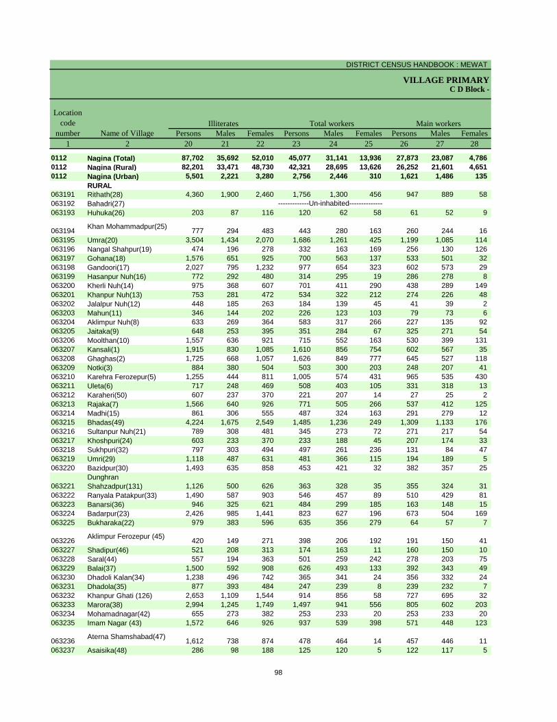
DISTRICT CENSUS HANDBOOK : MEWAT
VILLAGE PRIMARYC D Block -
Persons Males Females Persons Males Females Persons Males Females1 2 20 21 22 23 24 25 26 27 28
0112 Nagina (Total) 87,702 35,692 52,010 45,077 31,141 13,936 27,873 23,087 4,786 0112 Nagina (Rural) 82,201 33,471 48,730 42,321 28,695 13,626 26,252 21,601 4,651 0112 Nagina (Urban) 5,501 2,221 3,280 2,756 2,446 310 1,621 1,486 135
RURAL063191 Rithath(28) 4,360 1,900 2,460 1,756 1,300 456 947 889 58 063192 Bahadri(27)063193 Huhuka(26) 203 87 116 120 62 58 61 52 9
063194 Khan Mohammadpur(25) 777 294 483 443 280 163 260 244 16 063195 Umra(20) 3,504 1,434 2,070 1,686 1,261 425 1,199 1,085 114 063196 Nangal Shahpur(19) 474 196 278 332 163 169 256 130 126 063197 Gohana(18) 1,576 651 925 700 563 137 533 501 32 063198 Gandoori(17) 2,027 795 1,232 977 654 323 602 573 29 063199 Hasanpur Nuh(16) 772 292 480 314 295 19 286 278 8 063200 Kherli Nuh(14) 975 368 607 701 411 290 438 289 149 063201 Khanpur Nuh(13) 753 281 472 534 322 212 274 226 48 063202 Jalalpur Nuh(12) 448 185 263 184 139 45 41 39 2 063203 Mahun(11) 346 144 202 226 123 103 79 73 6 063204 Aklimpur Nuh(8) 633 269 364 583 317 266 227 135 92 063205 Jaitaka(9) 648 253 395 351 284 67 325 271 54 063206 Moolthan(10) 1,557 636 921 715 552 163 530 399 131 063207 Kansali(1) 1,915 830 1,085 1,610 856 754 602 567 35 063208 Ghaghas(2) 1,725 668 1,057 1,626 849 777 645 527 118 063209 Notki(3) 884 380 504 503 300 203 248 207 41 063210 Karehra Ferozepur(5) 1,255 444 811 1,005 574 431 965 535 430 063211 Uleta(6) 717 248 469 508 403 105 331 318 13 063212 Karaheri(50) 607 237 370 221 207 14 27 25 2 063213 Rajaka(7) 1,566 640 926 771 505 266 537 412 125 063214 Madhi(15) 861 306 555 487 324 163 291 279 12 063215 Bhadas(49) 4,224 1,675 2,549 1,485 1,236 249 1,309 1,133 176 063216 Sultanpur Nuh(21) 789 308 481 345 273 72 271 217 54 063217 Khoshpuri(24) 603 233 370 233 188 45 207 174 33 063218 Sukhpuri(32) 797 303 494 497 261 236 131 84 47 063219 Umri(29) 1,118 487 631 481 366 115 194 189 5 063220 Bazidpur(30) 1,493 635 858 453 421 32 382 357 25
063221Dunghran Shahzadpur(131) 1,126 500 626 363 328 35 355 324 31
063222 Ranyala Patakpur(33) 1,490 587 903 546 457 89 510 429 81 063223 Banarsi(36) 946 325 621 484 299 185 163 148 15 063224 Badarpur(23) 2,426 985 1,441 823 627 196 673 504 169 063225 Bukharaka(22) 979 383 596 635 356 279 64 57 7
063226 Aklimpur Ferozepur (45) 420 149 271 398 206 192 191 150 41 063227 Shadipur(46) 521 208 313 174 163 11 160 150 10 063228 Saral(44) 557 194 363 501 259 242 278 203 75 063229 Balai(37) 1,500 592 908 626 493 133 392 343 49 063230 Dhadoli Kalan(34) 1,238 496 742 365 341 24 356 332 24 063231 Dhadola(35) 877 393 484 247 239 8 239 232 7 063232 Khanpur Ghati (126) 2,653 1,109 1,544 914 856 58 727 695 32 063233 Marora(38) 2,994 1,245 1,749 1,497 941 556 805 602 203 063234 Mohamadnagar(42) 655 273 382 253 233 20 253 233 20 063235 Imam Nagar (43) 1,572 646 926 937 539 398 571 448 123
063236 Aterna Shamshabad(47) 1,612 738 874 478 464 14 457 446 11 063237 Asaisika(48) 286 98 188 125 120 5 122 117 5
Name of Village
Location code
numberIlliterates Total workers Main workers
-------------Un-inhabited--------------
98
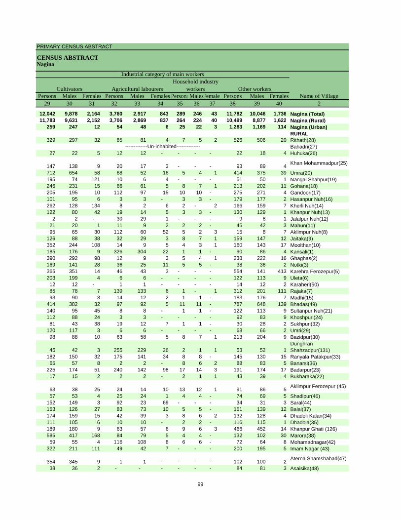
PRIMARY CENSUS ABSTRACT
CENSUS ABSTRACTNagina
Persons Males Females Persons Males Females PersonsMalesFemales Persons Males Females29 30 31 32 33 34 35 36 37 38 39 40 2
12,042 9,878 2,164 3,760 2,917 843 289 246 43 11,782 10,046 1,736 Nagina (Total)11,783 9,631 2,152 3,706 2,869 837 264 224 40 10,499 8,877 1,622 Nagina (Rural)
259 247 12 54 48 6 25 22 3 1,283 1,169 114 Nagina (Urban)RURAL
329 297 32 85 81 4 7 5 2 526 506 20 Rithath(28)Bahadri(27)
27 22 5 12 12 - - - - 22 18 4 Huhuka(26)
147 138 9 20 17 3 - - - 93 89 4 Khan Mohammadpur(25)
712 654 58 68 52 16 5 4 1 414 375 39 Umra(20)195 74 121 10 6 4 - - - 51 50 1 Nangal Shahpur(19)246 231 15 66 61 5 8 7 1 213 202 11 Gohana(18)205 195 10 112 97 15 10 10 - 275 271 4 Gandoori(17)101 95 6 3 3 - 3 3 - 179 177 2 Hasanpur Nuh(16)262 128 134 8 2 6 2 - 2 166 159 7 Kherli Nuh(14)122 80 42 19 14 5 3 3 - 130 129 1 Khanpur Nuh(13)
2 2 - 30 29 1 - - - 9 8 1 Jalalpur Nuh(12)21 20 1 11 9 2 2 2 - 45 42 3 Mahun(11)95 65 30 112 60 52 5 2 3 15 8 7 Aklimpur Nuh(8)
126 88 38 32 29 3 8 7 1 159 147 12 Jaitaka(9)352 244 108 14 9 5 4 3 1 160 143 17 Moolthan(10)185 176 9 326 304 22 1 1 - 90 86 4 Kansali(1)390 292 98 12 9 3 5 4 1 238 222 16 Ghaghas(2)169 141 28 36 25 11 5 5 - 38 36 2 Notki(3)365 351 14 46 43 3 - - - 554 141 413 Karehra Ferozepur(5)203 199 4 6 6 - - - - 122 113 9 Uleta(6)12 12 - 1 1 - - - - 14 12 2 Karaheri(50)85 78 7 139 133 6 1 - 1 312 201 111 Rajaka(7)93 90 3 14 12 2 1 1 - 183 176 7 Madhi(15)
414 382 32 97 92 5 11 11 - 787 648 139 Bhadas(49)140 95 45 8 8 - 1 1 - 122 113 9 Sultanpur Nuh(21)112 88 24 3 3 - - - - 92 83 9 Khoshpuri(24)81 43 38 19 12 7 1 1 - 30 28 2 Sukhpuri(32)
120 117 3 6 6 - - - - 68 66 2 Umri(29)98 88 10 63 58 5 8 7 1 213 204 9 Bazidpur(30)
45 42 3 255 229 26 2 1 1 53 52 1 Dunghran Shahzadpur(131)
182 150 32 175 141 34 8 8 - 145 130 15 Ranyala Patakpur(33)65 57 8 2 2 - 8 6 2 88 83 5 Banarsi(36)
225 174 51 240 142 98 17 14 3 191 174 17 Badarpur(23)17 15 2 2 2 - 2 1 1 43 39 4 Bukharaka(22)
63 38 25 24 14 10 13 12 1 91 86 5 Aklimpur Ferozepur (45)
57 53 4 25 24 1 4 4 - 74 69 5 Shadipur(46)152 149 3 92 23 69 - - - 34 31 3 Saral(44)153 126 27 83 73 10 5 5 - 151 139 12 Balai(37)174 159 15 42 39 3 8 6 2 132 128 4 Dhadoli Kalan(34)111 105 6 10 10 - 2 2 - 116 115 1 Dhadola(35)189 180 9 63 57 6 9 6 3 466 452 14 Khanpur Ghati (126)585 417 168 84 79 5 4 4 - 132 102 30 Marora(38)59 55 4 116 108 8 6 6 - 72 64 8 Mohamadnagar(42)
322 211 111 49 42 7 - - - 200 195 5 Imam Nagar (43)
354 345 9 1 1 - - - - 102 100 2 Aterna Shamshabad(47)
38 36 2 - - - - - - 84 81 3 Asaisika(48)
CultivatorsName of Village
Household industry workersAgricultural labourers
Industrial category of main workers
Other workers
-------------Un-inhabited--------------
99
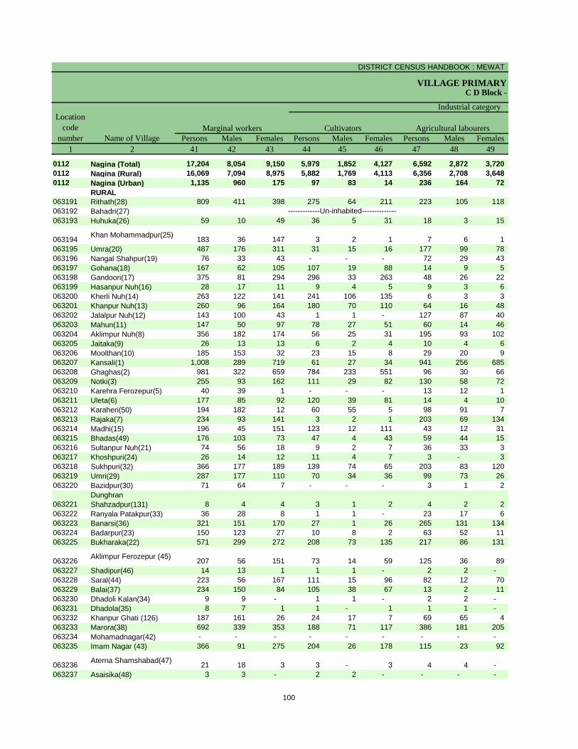
DISTRICT CENSUS HANDBOOK : MEWAT
VILLAGE PRIMARYC D Block -
Persons Males Females Persons Males Females Persons Males Females1 2 41 42 43 44 45 46 47 48 49
0112 Nagina (Total) 17,204 8,054 9,150 5,979 1,852 4,127 6,592 2,872 3,720 0112 Nagina (Rural) 16,069 7,094 8,975 5,882 1,769 4,113 6,356 2,708 3,648 0112 Nagina (Urban) 1,135 960 175 97 83 14 236 164 72
RURAL063191 Rithath(28) 809 411 398 275 64 211 223 105 118 063192 Bahadri(27)063193 Huhuka(26) 59 10 49 36 5 31 18 3 15
063194 Khan Mohammadpur(25) 183 36 147 3 2 1 7 6 1 063195 Umra(20) 487 176 311 31 15 16 177 99 78 063196 Nangal Shahpur(19) 76 33 43 - - - 72 29 43 063197 Gohana(18) 167 62 105 107 19 88 14 9 5 063198 Gandoori(17) 375 81 294 296 33 263 48 26 22 063199 Hasanpur Nuh(16) 28 17 11 9 4 5 9 3 6 063200 Kherli Nuh(14) 263 122 141 241 106 135 6 3 3 063201 Khanpur Nuh(13) 260 96 164 180 70 110 64 16 48 063202 Jalalpur Nuh(12) 143 100 43 1 1 - 127 87 40 063203 Mahun(11) 147 50 97 78 27 51 60 14 46 063204 Aklimpur Nuh(8) 356 182 174 56 25 31 195 93 102 063205 Jaitaka(9) 26 13 13 6 2 4 10 4 6 063206 Moolthan(10) 185 153 32 23 15 8 29 20 9 063207 Kansali(1) 1,008 289 719 61 27 34 941 256 685 063208 Ghaghas(2) 981 322 659 784 233 551 96 30 66 063209 Notki(3) 255 93 162 111 29 82 130 58 72 063210 Karehra Ferozepur(5) 40 39 1 - - - 13 12 1 063211 Uleta(6) 177 85 92 120 39 81 14 4 10 063212 Karaheri(50) 194 182 12 60 55 5 98 91 7 063213 Rajaka(7) 234 93 141 3 2 1 203 69 134 063214 Madhi(15) 196 45 151 123 12 111 43 12 31 063215 Bhadas(49) 176 103 73 47 4 43 59 44 15 063216 Sultanpur Nuh(21) 74 56 18 9 2 7 36 33 3 063217 Khoshpuri(24) 26 14 12 11 4 7 3 - 3 063218 Sukhpuri(32) 366 177 189 139 74 65 203 83 120 063219 Umri(29) 287 177 110 70 34 36 99 73 26 063220 Bazidpur(30) 71 64 7 - - - 3 1 2
063221Dunghran Shahzadpur(131) 8 4 4 3 1 2 4 2 2
063222 Ranyala Patakpur(33) 36 28 8 1 1 - 23 17 6 063223 Banarsi(36) 321 151 170 27 1 26 265 131 134 063224 Badarpur(23) 150 123 27 10 8 2 63 52 11 063225 Bukharaka(22) 571 299 272 208 73 135 217 86 131
063226 Aklimpur Ferozepur (45) 207 56 151 73 14 59 125 36 89 063227 Shadipur(46) 14 13 1 1 1 - 2 2 - 063228 Saral(44) 223 56 167 111 15 96 82 12 70 063229 Balai(37) 234 150 84 105 38 67 13 2 11 063230 Dhadoli Kalan(34) 9 9 - 1 1 - 2 2 - 063231 Dhadola(35) 8 7 1 1 - 1 1 1 - 063232 Khanpur Ghati (126) 187 161 26 24 17 7 69 65 4 063233 Marora(38) 692 339 353 188 71 117 386 181 205 063234 Mohamadnagar(42) - - - - - - - - - 063235 Imam Nagar (43) 366 91 275 204 26 178 115 23 92
063236 Aterna Shamshabad(47) 21 18 3 3 - 3 4 4 - 063237 Asaisika(48) 3 3 - 2 2 - - - -
Name of VillageMarginal workers Cultivators Agricultural labourers
Industrial category Location
code number
-------------Un-inhabited--------------
100
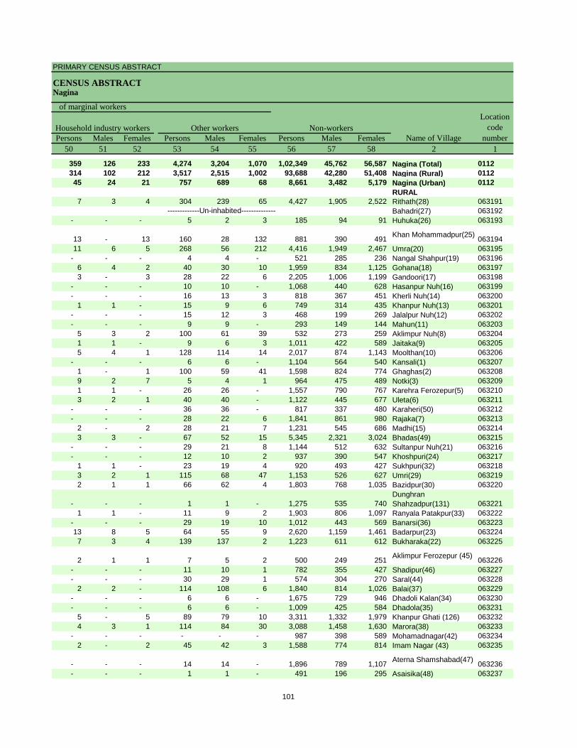
PRIMARY CENSUS ABSTRACT
CENSUS ABSTRACTNagina
Persons Males Females Persons Males Females Persons Males Females50 51 52 53 54 55 56 57 58 2 1
359 126 233 4,274 3,204 1,070 1,02,349 45,762 56,587 Nagina (Total) 0112314 102 212 3,517 2,515 1,002 93,688 42,280 51,408 Nagina (Rural) 011245 24 21 757 689 68 8,661 3,482 5,179 Nagina (Urban) 0112
RURAL7 3 4 304 239 65 4,427 1,905 2,522 Rithath(28) 063191
Bahadri(27) 063192- - - 5 2 3 185 94 91 Huhuka(26) 063193
13 - 13 160 28 132 881 390 491 Khan Mohammadpur(25) 06319411 6 5 268 56 212 4,416 1,949 2,467 Umra(20) 063195
- - - 4 4 - 521 285 236 Nangal Shahpur(19) 0631966 4 2 40 30 10 1,959 834 1,125 Gohana(18) 0631973 - 3 28 22 6 2,205 1,006 1,199 Gandoori(17) 063198
- - - 10 10 - 1,068 440 628 Hasanpur Nuh(16) 063199- - - 16 13 3 818 367 451 Kherli Nuh(14) 063200
1 1 - 15 9 6 749 314 435 Khanpur Nuh(13) 063201- - - 15 12 3 468 199 269 Jalalpur Nuh(12) 063202- - - 9 9 - 293 149 144 Mahun(11) 063203
5 3 2 100 61 39 532 273 259 Aklimpur Nuh(8) 0632041 1 - 9 6 3 1,011 422 589 Jaitaka(9) 0632055 4 1 128 114 14 2,017 874 1,143 Moolthan(10) 063206
- - - 6 6 - 1,104 564 540 Kansali(1) 0632071 - 1 100 59 41 1,598 824 774 Ghaghas(2) 0632089 2 7 5 4 1 964 475 489 Notki(3) 0632091 1 - 26 26 - 1,557 790 767 Karehra Ferozepur(5) 0632103 2 1 40 40 - 1,122 445 677 Uleta(6) 063211
- - - 36 36 - 817 337 480 Karaheri(50) 063212- - - 28 22 6 1,841 861 980 Rajaka(7) 063213
2 - 2 28 21 7 1,231 545 686 Madhi(15) 0632143 3 - 67 52 15 5,345 2,321 3,024 Bhadas(49) 063215
- - - 29 21 8 1,144 512 632 Sultanpur Nuh(21) 063216- - - 12 10 2 937 390 547 Khoshpuri(24) 063217
1 1 - 23 19 4 920 493 427 Sukhpuri(32) 0632183 2 1 115 68 47 1,153 526 627 Umri(29) 0632192 1 1 66 62 4 1,803 768 1,035 Bazidpur(30) 063220
- - - 1 1 - 1,275 535 740 Dunghran Shahzadpur(131) 063221
1 1 - 11 9 2 1,903 806 1,097 Ranyala Patakpur(33) 063222- - - 29 19 10 1,012 443 569 Banarsi(36) 06322313 8 5 64 55 9 2,620 1,159 1,461 Badarpur(23) 0632247 3 4 139 137 2 1,223 611 612 Bukharaka(22) 063225
2 1 1 7 5 2 500 249 251 Aklimpur Ferozepur (45) 063226- - - 11 10 1 782 355 427 Shadipur(46) 063227- - - 30 29 1 574 304 270 Saral(44) 063228
2 2 - 114 108 6 1,840 814 1,026 Balai(37) 063229- - - 6 6 - 1,675 729 946 Dhadoli Kalan(34) 063230- - - 6 6 - 1,009 425 584 Dhadola(35) 063231
5 - 5 89 79 10 3,311 1,332 1,979 Khanpur Ghati (126) 0632324 3 1 114 84 30 3,088 1,458 1,630 Marora(38) 063233
- - - - - - 987 398 589 Mohamadnagar(42) 0632342 - 2 45 42 3 1,588 774 814 Imam Nagar (43) 063235
- - - 14 14 - 1,896 789 1,107 Aterna Shamshabad(47) 063236- - - 1 1 - 491 196 295 Asaisika(48) 063237
Location code
numberHousehold industry workers
Name of VillageOther workers Non-workers
of marginal workers
-------------Un-inhabited--------------
101
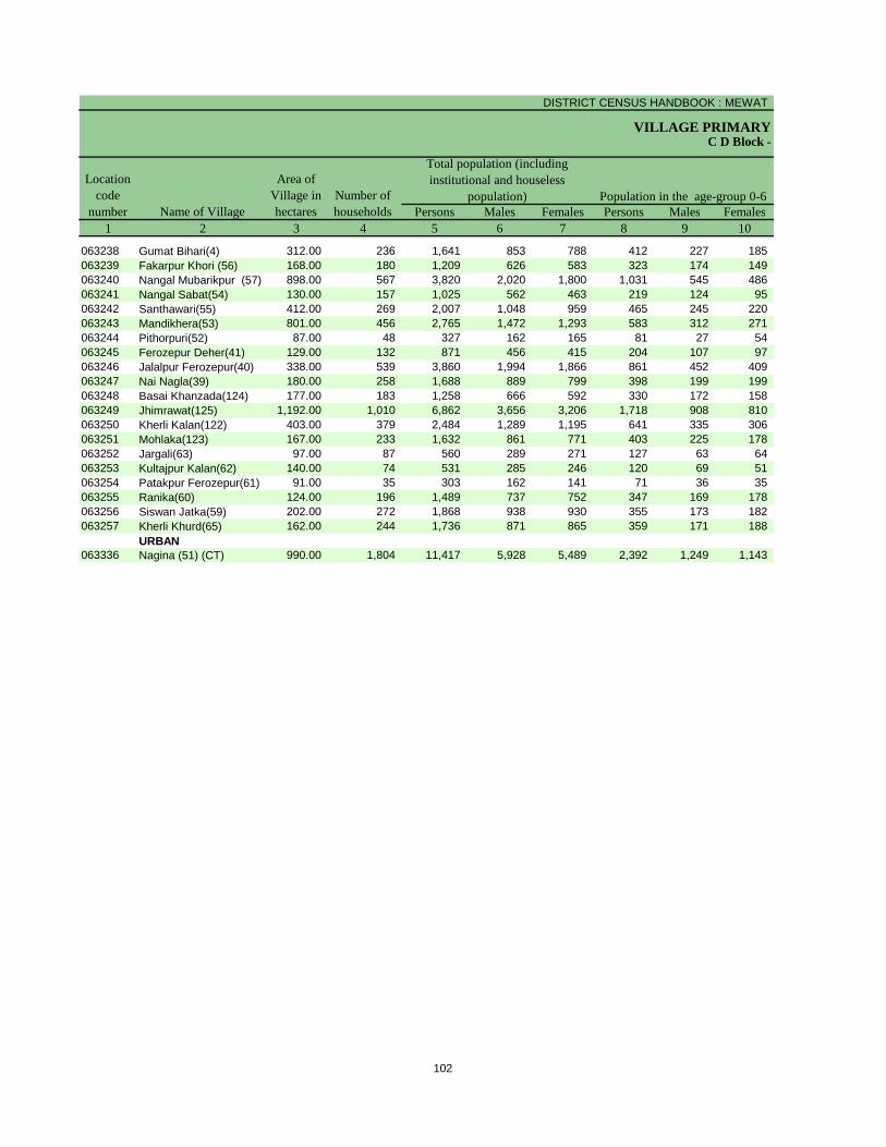
DISTRICT CENSUS HANDBOOK : MEWAT
VILLAGE PRIMARY
Persons Males Females Persons Males Females1 2 3 4 5 6 7 8 9 10
Name of Village
Location code
number
Total population (including institutional and houseless
population)Area of
Village in hectares
Number of households
C D Block -
Population in the age-group 0-6
063238 Gumat Bihari(4) 312.00 236 1,641 853 788 412 227 185 063239 Fakarpur Khori (56) 168.00 180 1,209 626 583 323 174 149 063240 Nangal Mubarikpur (57) 898.00 567 3,820 2,020 1,800 1,031 545 486 063241 Nangal Sabat(54) 130.00 157 1,025 562 463 219 124 95 063242 Santhawari(55) 412.00 269 2,007 1,048 959 465 245 220 063243 Mandikhera(53) 801.00 456 2,765 1,472 1,293 583 312 271 063244 Pithorpuri(52) 87.00 48 327 162 165 81 27 54 063245 Ferozepur Deher(41) 129.00 132 871 456 415 204 107 97 063246 Jalalpur Ferozepur(40) 338.00 539 3,860 1,994 1,866 861 452 409 063247 Nai Nagla(39) 180.00 258 1,688 889 799 398 199 199 063248 Basai Khanzada(124) 177.00 183 1,258 666 592 330 172 158 063249 Jhimrawat(125) 1,192.00 1,010 6,862 3,656 3,206 1,718 908 810 063250 Kherli Kalan(122) 403.00 379 2,484 1,289 1,195 641 335 306 063251 Mohlaka(123) 167.00 233 1,632 861 771 403 225 178 063252 Jargali(63) 97.00 87 560 289 271 127 63 64 063253 Kultajpur Kalan(62) 140.00 74 531 285 246 120 69 51 063254 Patakpur Ferozepur(61) 91.00 35 303 162 141 71 36 35 063255 Ranika(60) 124.00 196 1,489 737 752 347 169 178 063256 Siswan Jatka(59) 202.00 272 1,868 938 930 355 173 182 063257 Kherli Khurd(65) 162.00 244 1,736 871 865 359 171 188
URBAN063336 Nagina (51) (CT) 990.00 1,804 11,417 5,928 5,489 2,392 1,249 1,143
102
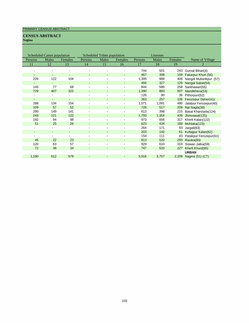
PRIMARY CENSUS ABSTRACT
CENSUS ABSTRACTNagina
Persons Males Females Persons Males Females Persons Males Females11 12 13 14 15 16 17 18 19 2
Name of VillageLiteratesScheduled Castes population Scheduled Tribes population
- - - - - - 744 501 243 Gumat Bihari(4)- - - - - - 467 308 159 Fakarpur Khori (56)226 122 104 - - - 1,395 989 406 Nangal Mubarikpur (57)- - - - - - 456 327 129 Nangal Sabat(54)145 77 68 - - - 844 586 258 Santhawari(55)729 407 322 - - - 1,390 883 507 Mandikhera(53)- - - - - - 126 90 36 Pithorpuri(52)- - - - - - 363 257 106 Ferozepur Deher(41)288 134 154 - - - 1,571 1,091 480 Jalalpur Ferozepur(40)109 57 52 - - - 726 517 209 Nai Nagla(39)290 149 141 - - - 613 398 215 Basai Khanzada(124)243 121 122 - - - 1,793 1,354 439 Jhimrawat(125)192 94 98 - - - 973 656 317 Kherli Kalan(122)51 25 26 - - - 623 434 189 Mohlaka(123)
- - - - - - 264 171 93 Jargali(63)- - - - - - 203 142 61 Kultajpur Kalan(62)- - - - - - 154 111 43 Patakpur Ferozepur(61)45 22 23 - - - 813 520 293 Ranika(60)
120 63 57 - - - 929 610 319 Siswan Jatka(59)72 38 34 - - - 747 520 227 Kherli Khurd(65)
URBAN1,190 612 578 - - - 5,916 3,707 2,209 Nagina (51) (CT)
103
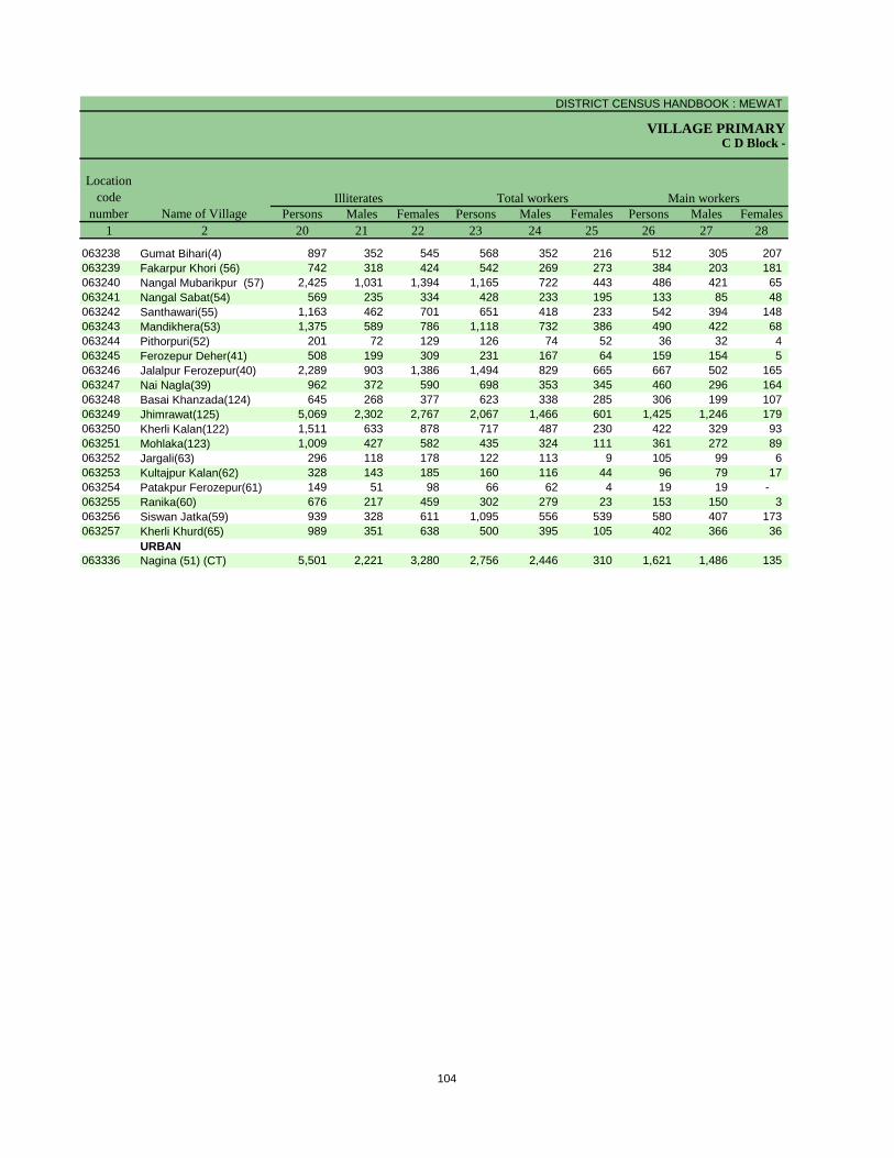
DISTRICT CENSUS HANDBOOK : MEWAT
VILLAGE PRIMARYC D Block -
Persons Males Females Persons Males Females Persons Males Females1 2 20 21 22 23 24 25 26 27 28
Name of Village
Location code
numberIlliterates Total workers Main workers
063238 Gumat Bihari(4) 897 352 545 568 352 216 512 305 207 063239 Fakarpur Khori (56) 742 318 424 542 269 273 384 203 181 063240 Nangal Mubarikpur (57) 2,425 1,031 1,394 1,165 722 443 486 421 65 063241 Nangal Sabat(54) 569 235 334 428 233 195 133 85 48 063242 Santhawari(55) 1,163 462 701 651 418 233 542 394 148 063243 Mandikhera(53) 1,375 589 786 1,118 732 386 490 422 68 063244 Pithorpuri(52) 201 72 129 126 74 52 36 32 4 063245 Ferozepur Deher(41) 508 199 309 231 167 64 159 154 5 063246 Jalalpur Ferozepur(40) 2,289 903 1,386 1,494 829 665 667 502 165 063247 Nai Nagla(39) 962 372 590 698 353 345 460 296 164 063248 Basai Khanzada(124) 645 268 377 623 338 285 306 199 107 063249 Jhimrawat(125) 5,069 2,302 2,767 2,067 1,466 601 1,425 1,246 179 063250 Kherli Kalan(122) 1,511 633 878 717 487 230 422 329 93 063251 Mohlaka(123) 1,009 427 582 435 324 111 361 272 89 063252 Jargali(63) 296 118 178 122 113 9 105 99 6 063253 Kultajpur Kalan(62) 328 143 185 160 116 44 96 79 17 063254 Patakpur Ferozepur(61) 149 51 98 66 62 4 19 19 - 063255 Ranika(60) 676 217 459 302 279 23 153 150 3 063256 Siswan Jatka(59) 939 328 611 1,095 556 539 580 407 173 063257 Kherli Khurd(65) 989 351 638 500 395 105 402 366 36
URBAN063336 Nagina (51) (CT) 5,501 2,221 3,280 2,756 2,446 310 1,621 1,486 135
104
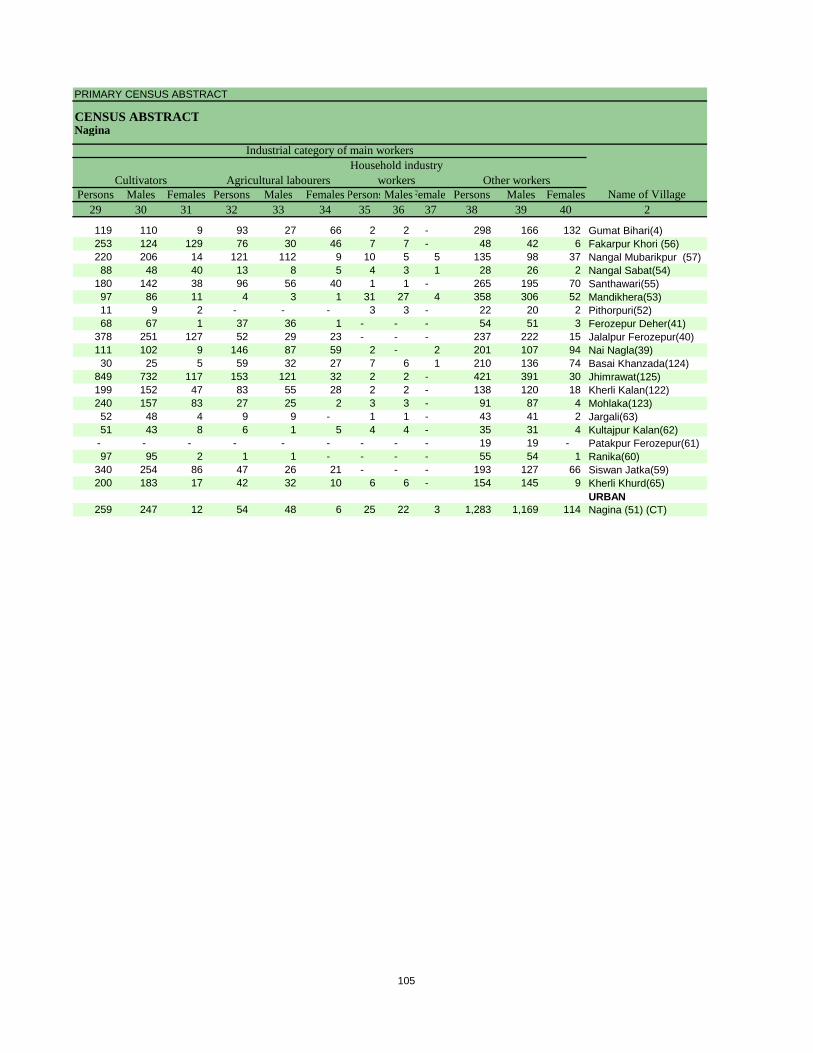
PRIMARY CENSUS ABSTRACT
CENSUS ABSTRACTNagina
Persons Males Females Persons Males Females PersonsMalesFemales Persons Males Females29 30 31 32 33 34 35 36 37 38 39 40 2
CultivatorsName of Village
Household industry workersAgricultural labourers
Industrial category of main workers
Other workers
119 110 9 93 27 66 2 2 - 298 166 132 Gumat Bihari(4)253 124 129 76 30 46 7 7 - 48 42 6 Fakarpur Khori (56)220 206 14 121 112 9 10 5 5 135 98 37 Nangal Mubarikpur (57)88 48 40 13 8 5 4 3 1 28 26 2 Nangal Sabat(54)
180 142 38 96 56 40 1 1 - 265 195 70 Santhawari(55)97 86 11 4 3 1 31 27 4 358 306 52 Mandikhera(53)11 9 2 - - - 3 3 - 22 20 2 Pithorpuri(52)68 67 1 37 36 1 - - - 54 51 3 Ferozepur Deher(41)
378 251 127 52 29 23 - - - 237 222 15 Jalalpur Ferozepur(40)111 102 9 146 87 59 2 - 2 201 107 94 Nai Nagla(39)30 25 5 59 32 27 7 6 1 210 136 74 Basai Khanzada(124)
849 732 117 153 121 32 2 2 - 421 391 30 Jhimrawat(125)199 152 47 83 55 28 2 2 - 138 120 18 Kherli Kalan(122)240 157 83 27 25 2 3 3 - 91 87 4 Mohlaka(123)52 48 4 9 9 - 1 1 - 43 41 2 Jargali(63)51 43 8 6 1 5 4 4 - 35 31 4 Kultajpur Kalan(62)
- - - - - - - - - 19 19 - Patakpur Ferozepur(61)97 95 2 1 1 - - - - 55 54 1 Ranika(60)
340 254 86 47 26 21 - - - 193 127 66 Siswan Jatka(59)200 183 17 42 32 10 6 6 - 154 145 9 Kherli Khurd(65)
URBAN259 247 12 54 48 6 25 22 3 1,283 1,169 114 Nagina (51) (CT)
105
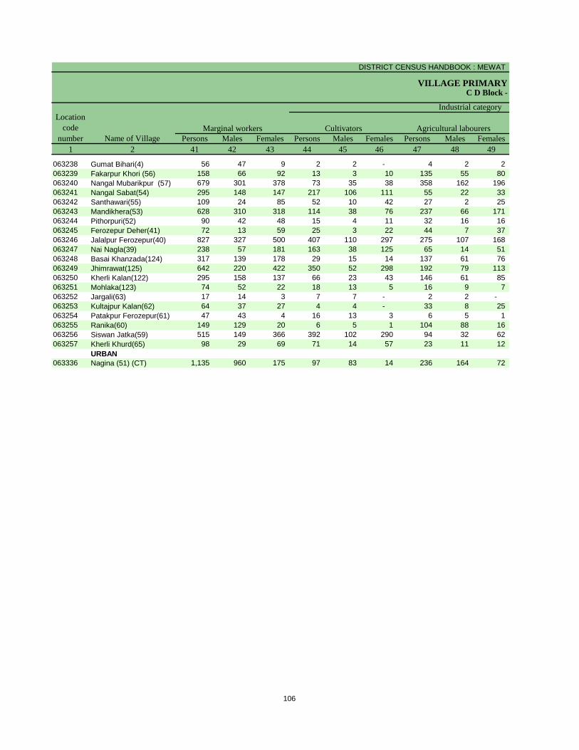
DISTRICT CENSUS HANDBOOK : MEWAT
VILLAGE PRIMARYC D Block -
Persons Males Females Persons Males Females Persons Males Females1 2 41 42 43 44 45 46 47 48 49
Name of VillageMarginal workers Cultivators Agricultural labourers
Industrial category Location
code number
063238 Gumat Bihari(4) 56 47 9 2 2 - 4 2 2 063239 Fakarpur Khori (56) 158 66 92 13 3 10 135 55 80 063240 Nangal Mubarikpur (57) 679 301 378 73 35 38 358 162 196 063241 Nangal Sabat(54) 295 148 147 217 106 111 55 22 33 063242 Santhawari(55) 109 24 85 52 10 42 27 2 25 063243 Mandikhera(53) 628 310 318 114 38 76 237 66 171 063244 Pithorpuri(52) 90 42 48 15 4 11 32 16 16 063245 Ferozepur Deher(41) 72 13 59 25 3 22 44 7 37 063246 Jalalpur Ferozepur(40) 827 327 500 407 110 297 275 107 168 063247 Nai Nagla(39) 238 57 181 163 38 125 65 14 51 063248 Basai Khanzada(124) 317 139 178 29 15 14 137 61 76 063249 Jhimrawat(125) 642 220 422 350 52 298 192 79 113 063250 Kherli Kalan(122) 295 158 137 66 23 43 146 61 85 063251 Mohlaka(123) 74 52 22 18 13 5 16 9 7 063252 Jargali(63) 17 14 3 7 7 - 2 2 - 063253 Kultajpur Kalan(62) 64 37 27 4 4 - 33 8 25 063254 Patakpur Ferozepur(61) 47 43 4 16 13 3 6 5 1 063255 Ranika(60) 149 129 20 6 5 1 104 88 16 063256 Siswan Jatka(59) 515 149 366 392 102 290 94 32 62 063257 Kherli Khurd(65) 98 29 69 71 14 57 23 11 12
URBAN063336 Nagina (51) (CT) 1,135 960 175 97 83 14 236 164 72
106
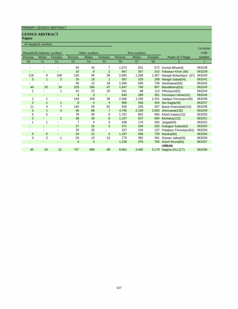
PRIMARY CENSUS ABSTRACT
CENSUS ABSTRACTNagina
Persons Males Females Persons Males Females Persons Males Females50 51 52 53 54 55 56 57 58 2 1
Location code
numberHousehold industry workers
Name of VillageOther workers Non-workers
of marginal workers
- - - 50 43 7 1,073 501 572 Gumat Bihari(4) 063238- - - 10 8 2 667 357 310 Fakarpur Khori (56) 063239118 9 109 130 95 35 2,655 1,298 1,357 Nangal Mubarikpur (57) 063240
3 1 2 20 19 1 597 329 268 Nangal Sabat(54) 063241- - - 30 12 18 1,356 630 726 Santhawari(55) 06324244 20 24 233 186 47 1,647 740 907 Mandikhera(53) 0632431 - 1 42 22 20 201 88 113 Pithorpuri(52) 063244
- - - 3 3 - 640 289 351 Ferozepur Deher(41) 0632451 1 - 144 109 35 2,366 1,165 1,201 Jalalpur Ferozepur(40) 0632462 1 1 8 4 4 990 536 454 Nai Nagla(39) 063247
11 4 7 140 59 81 635 328 307 Basai Khanzada(124) 0632485 1 4 95 88 7 4,795 2,190 2,605 Jhimrawat(125) 0632495 5 - 78 69 9 1,767 802 965 Kherli Kalan(122) 0632502 - 2 38 30 8 1,197 537 660 Mohlaka(123) 0632511 1 - 7 4 3 438 176 262 Jargali(63) 063252
- - - 27 25 2 371 169 202 Kultajpur Kalan(62) 063253- - - 25 25 - 237 100 137 Patakpur Ferozepur(61) 063254
5 5 - 34 31 3 1,187 458 729 Ranika(60) 0632553 2 1 26 13 13 773 382 391 Siswan Jatka(59) 063256
- - - 4 4 - 1,236 476 760 Kherli Khurd(65) 063257URBAN
45 24 21 757 689 68 8,661 3,482 5,179 Nagina (51) (CT) 063336
107
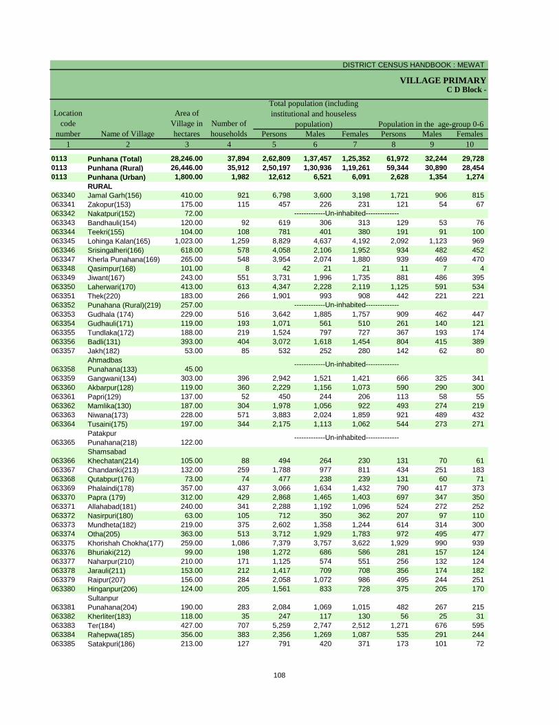
DISTRICT CENSUS HANDBOOK : MEWAT
VILLAGE PRIMARY
Persons Males Females Persons Males Females1 2 3 4 5 6 7 8 9 10
0113 Punhana (Total) 28,246.00 37,894 2,62,809 1,37,457 1,25,352 61,972 32,244 29,728 0113 Punhana (Rural) 26,446.00 35,912 2,50,197 1,30,936 1,19,261 59,344 30,890 28,454 0113 Punhana (Urban) 1,800.00 1,982 12,612 6,521 6,091 2,628 1,354 1,274
RURAL063340 Jamal Garh(156) 410.00 921 6,798 3,600 3,198 1,721 906 815 063341 Zakopur(153) 175.00 115 457 226 231 121 54 67 063342 Nakatpuri(152) 72.00063343 Bandhauli(154) 120.00 92 619 306 313 129 53 76 063344 Teekri(155) 104.00 108 781 401 380 191 91 100 063345 Lohinga Kalan(165) 1,023.00 1,259 8,829 4,637 4,192 2,092 1,123 969 063346 Srisingalheri(166) 618.00 578 4,058 2,106 1,952 934 482 452 063347 Kherla Punahana(169) 265.00 548 3,954 2,074 1,880 939 469 470 063348 Qasimpur(168) 101.00 8 42 21 21 11 7 4 063349 Jiwant(167) 243.00 551 3,731 1,996 1,735 881 486 395 063350 Laherwari(170) 413.00 613 4,347 2,228 2,119 1,125 591 534 063351 Thek(220) 183.00 266 1,901 993 908 442 221 221 063352 Punahana (Rural)(219) 257.00063353 Gudhala (174) 229.00 516 3,642 1,885 1,757 909 462 447 063354 Gudhauli(171) 119.00 193 1,071 561 510 261 140 121 063355 Tundlaka(172) 188.00 219 1,524 797 727 367 193 174 063356 Badli(131) 393.00 404 3,072 1,618 1,454 804 415 389 063357 Jakh(182) 53.00 85 532 252 280 142 62 80
063358Ahmadbas Punahana(133) 45.00
063359 Gangwani(134) 303.00 396 2,942 1,521 1,421 666 325 341 063360 Akbarpur(128) 119.00 360 2,229 1,156 1,073 590 290 300 063361 Papri(129) 137.00 52 450 244 206 113 58 55 063362 Mamlika(130) 187.00 304 1,978 1,056 922 493 274 219 063363 Niwana(173) 228.00 571 3,883 2,024 1,859 921 489 432 063364 Tusaini(175) 197.00 344 2,175 1,113 1,062 544 273 271
063365Patakpur Punahana(218) 122.00
063366Shamsabad Khechatan(214) 105.00 88 494 264 230 131 70 61
063367 Chandanki(213) 132.00 259 1,788 977 811 434 251 183 063368 Qutabpur(176) 73.00 74 477 238 239 131 60 71 063369 Phalaindi(178) 357.00 437 3,066 1,634 1,432 790 417 373 063370 Papra (179) 312.00 429 2,868 1,465 1,403 697 347 350 063371 Allahabad(181) 240.00 341 2,288 1,192 1,096 524 272 252 063372 Nasirpuri(180) 63.00 105 712 350 362 207 97 110 063373 Mundheta(182) 219.00 375 2,602 1,358 1,244 614 314 300 063374 Otha(205) 363.00 513 3,712 1,929 1,783 972 495 477 063375 Khorishah Chokha(177) 259.00 1,086 7,379 3,757 3,622 1,929 990 939 063376 Bhuriaki(212) 99.00 198 1,272 686 586 281 157 124 063377 Naharpur(210) 210.00 171 1,125 574 551 256 132 124 063378 Jarauli(211) 153.00 212 1,417 709 708 356 174 182 063379 Raipur(207) 156.00 284 2,058 1,072 986 495 244 251 063380 Hinganpur(206) 124.00 205 1,561 833 728 375 205 170
063381Sultanpur Punahana(204) 190.00 283 2,084 1,069 1,015 482 267 215
063382 Kherliter(183) 118.00 35 247 117 130 56 25 31 063383 Ter(184) 427.00 707 5,259 2,747 2,512 1,271 676 595 063384 Rahepwa(185) 356.00 383 2,356 1,269 1,087 535 291 244 063385 Satakpuri(186) 213.00 127 791 420 371 173 101 72
Name of Village
Location code
number
Total population (including institutional and houseless
population)Area of
Village in hectares
Number of households
C D Block -
Population in the age-group 0-6
-------------Un-inhabited--------------
-------------Un-inhabited--------------
-------------Un-inhabited--------------
-------------Un-inhabited--------------
108
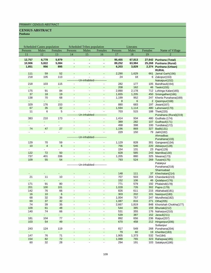
PRIMARY CENSUS ABSTRACT
CENSUS ABSTRACTPunhana
Persons Males Females Persons Males Females Persons Males Females11 12 13 14 15 16 17 18 19 2
12,757 6,778 5,979 - - - 95,455 67,813 27,642 Punhana (Total)10,906 5,822 5,084 - - - 89,252 63,984 25,268 Punhana (Rural)1,851 956 895 - - - 6,203 3,829 2,374 Punhana (Urban)
RURAL111 59 52 - - - 2,290 1,629 661 Jamal Garh(156)218 105 113 - - - 24 18 6 Zakopur(153)
Nakatpuri(152)218 103 115 - - - 282 177 105 Bandhauli(154)- - - - - - 208 162 46 Teekri(155)175 91 84 - - - 2,890 2,178 712 Lohinga Kalan(165)37 18 19 - - - 1,655 1,205 450 Srisingalheri(166)
138 70 68 - - - 1,199 952 247 Kherla Punahana(169)- - - - - - 8 6 2 Qasimpur(168)329 176 153 - - - 880 683 197 Jiwant(167)67 35 32 - - - 1,594 1,114 480 Laherwari(170)11 6 5 - - - 703 515 188 Thek(220)
Punahana (Rural)(219)383 210 173 - - - 1,414 934 480 Gudhala (174)- - - - - - 389 282 107 Gudhauli(171)- - - - - - 498 398 100 Tundlaka(172)74 47 27 - - - 1,196 869 327 Badli(131)
- - - - - - 229 150 79 Jakh(182)Ahmadbas Punahana(133)
129 70 59 - - - 1,129 828 301 Gangwani(134)10 4 6 - - - 766 546 220 Akbarpur(128)
- - - - - - 154 131 23 Papri(129)122 72 50 - - - 828 585 243 Mamlika(130)737 401 336 - - - 1,205 880 325 Niwana(173)109 55 54 - - - 793 524 269 Tusaini(175)
Patakpur Punahana(218)
- - - - - - 148 111 37 Shamsabad Khechatan(214)
21 11 10 - - - 707 503 204 Chandanki(213)- - - - - - 152 106 46 Qutabpur(176)171 91 80 - - - 771 579 192 Phalaindi(178)201 100 101 - - - 1,028 726 302 Papra (179)142 76 66 - - - 826 611 215 Allahabad(181)16 10 6 - - - 303 202 101 Nasirpuri(180)68 32 36 - - - 1,004 757 247 Mundheta(182)69 37 32 - - - 1,087 816 271 Otha(205)74 39 35 - - - 2,667 1,819 848 Khorishah Chokha(177)
109 61 48 - - - 544 385 159 Bhuriaki(212)140 74 66 - - - 531 355 176 Naharpur(210)- - - - - - 539 387 152 Jarauli(211)181 104 77 - - - 892 656 236 Raipur(207)103 54 49 - - - 670 458 212 Hinganpur(206)
243 124 119 - - - 817 549 268 Sultanpur Punahana(204)
- - - - - - 79 60 19 Kherliter(183)147 76 71 - - - 1,905 1,373 532 Ter(184)154 82 72 - - - 1,088 765 323 Rahepwa(185)60 32 28 - - - 294 191 103 Satakpuri(186)
Name of VillageLiteratesScheduled Castes population Scheduled Tribes population
-------------Un-inhabited--------------
-------------Un-inhabited--------------
-------------Un-inhabited--------------
-------------Un-inhabited--------------
109
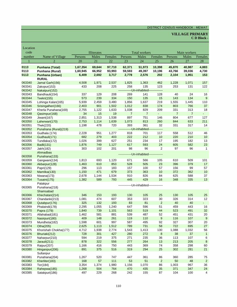
DISTRICT CENSUS HANDBOOK : MEWAT
VILLAGE PRIMARYC D Block -
Persons Males Females Persons Males Females Persons Males Females1 2 20 21 22 23 24 25 26 27 28
0113 Punhana (Total) 1,67,354 69,644 97,710 62,371 51,973 10,398 45,870 40,987 4,883 0113 Punhana (Rural) 1,60,945 66,952 93,993 59,593 49,397 10,196 43,766 39,036 4,730 0113 Punhana (Urban) 6,409 2,692 3,717 2,778 2,576 202 2,104 1,951 153
RURAL063340 Jamal Garh(156) 4,508 1,971 2,537 1,825 1,363 462 1,228 1,071 157 063341 Zakopur(153) 433 208 225 258 135 123 253 131 122 063342 Nakatpuri(152)063343 Bandhauli(154) 337 129 208 269 141 128 40 24 16 063344 Teekri(155) 573 239 334 150 135 15 143 134 9 063345 Lohinga Kalan(165) 5,939 2,459 3,480 1,856 1,637 219 1,555 1,445 110 063346 Srisingalheri(166) 2,403 901 1,502 1,012 838 174 803 766 37 063347 Kherla Punahana(169) 2,755 1,122 1,633 1,038 829 209 331 313 18 063348 Qasimpur(168) 34 15 19 7 7 - 7 7 - 063349 Jiwant(167) 2,851 1,313 1,538 897 751 146 804 677 127 063350 Laherwari(170) 2,753 1,114 1,639 1,073 813 260 844 633 211 063351 Thek(220) 1,198 478 720 393 361 32 331 317 14 063352 Punahana (Rural)(219)063353 Gudhala (174) 2,228 951 1,277 818 701 117 558 512 46 063354 Gudhauli(171) 682 279 403 222 212 10 220 210 10 063355 Tundlaka(172) 1,026 399 627 251 234 17 195 182 13 063356 Badli(131) 1,876 749 1,127 617 593 24 605 582 23 063357 Jakh(182) 303 102 201 98 96 2 97 96 1
063358Ahmadbas Punahana(133)
063359 Gangwani(134) 1,813 693 1,120 671 566 105 610 509 101 063360 Akbarpur(128) 1,463 610 853 528 505 23 396 379 17 063361 Papri(129) 296 113 183 157 100 57 156 99 57 063362 Mamlika(130) 1,150 471 679 373 363 10 372 362 10 063363 Niwana(173) 2,678 1,144 1,534 910 826 84 625 588 37 063364 Tusaini(175) 1,382 589 793 445 429 16 348 335 13
063365Patakpur Punahana(218)
063366Shamsabad Khechatan(214) 346 153 193 130 105 25 130 105 25
063367 Chandanki(213) 1,081 474 607 353 323 30 326 314 12 063368 Qutabpur(176) 325 132 193 83 81 2 40 40 - 063369 Phalaindi(178) 2,295 1,055 1,240 647 596 51 459 443 16 063370 Papra (179) 1,840 739 1,101 563 519 44 523 491 32 063371 Allahabad(181) 1,462 581 881 539 487 52 451 431 20 063372 Nasirpuri(180) 409 148 261 119 110 9 116 107 9 063373 Mundheta(182) 1,598 601 997 587 495 92 327 307 20 063374 Otha(205) 2,625 1,113 1,512 789 731 58 722 695 27 063375 Khorishah Chokha(177) 4,712 1,938 2,774 1,543 1,413 130 1,088 1,032 56 063376 Bhuriaki(212) 728 301 427 280 272 8 38 37 1 063377 Naharpur(210) 594 219 375 271 235 36 113 107 6 063378 Jarauli(211) 878 322 556 277 264 13 213 205 8 063379 Raipur(207) 1,166 416 750 443 369 74 358 298 60 063380 Hinganpur(206) 891 375 516 319 294 25 302 281 21
063381Sultanpur Punahana(204) 1,267 520 747 447 361 86 360 285 75
063382 Kherliter(183) 168 57 111 53 51 2 50 48 2 063383 Ter(184) 3,354 1,374 1,980 1,156 1,070 86 1,003 967 36 063384 Rahepwa(185) 1,268 504 764 470 435 35 371 347 24 063385 Satakpuri(186) 497 229 268 242 155 87 104 100 4
Name of Village
Location code
numberIlliterates Total workers Main workers
-------------Un-inhabited--------------
-------------Un-inhabited--------------
-------------Un-inhabited--------------
-------------Un-inhabited--------------
110
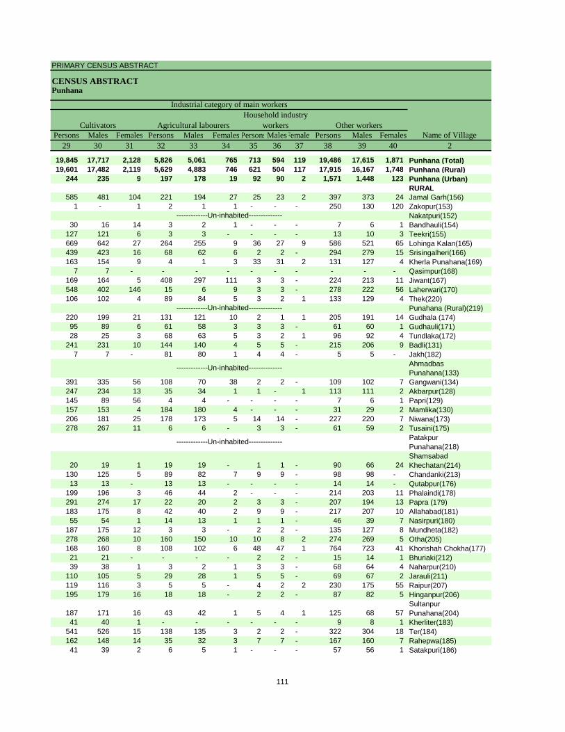
PRIMARY CENSUS ABSTRACT
CENSUS ABSTRACTPunhana
Persons Males Females Persons Males Females PersonsMalesFemales Persons Males Females29 30 31 32 33 34 35 36 37 38 39 40 2
19,845 17,717 2,128 5,826 5,061 765 713 594 119 19,486 17,615 1,871 Punhana (Total)19,601 17,482 2,119 5,629 4,883 746 621 504 117 17,915 16,167 1,748 Punhana (Rural)
244 235 9 197 178 19 92 90 2 1,571 1,448 123 Punhana (Urban)RURAL
585 481 104 221 194 27 25 23 2 397 373 24 Jamal Garh(156)1 - 1 2 1 1 - - - 250 130 120 Zakopur(153)
Nakatpuri(152)30 16 14 3 2 1 - - - 7 6 1 Bandhauli(154)
127 121 6 3 3 - - - - 13 10 3 Teekri(155)669 642 27 264 255 9 36 27 9 586 521 65 Lohinga Kalan(165)439 423 16 68 62 6 2 2 - 294 279 15 Srisingalheri(166)163 154 9 4 1 3 33 31 2 131 127 4 Kherla Punahana(169)
7 7 - - - - - - - - - - Qasimpur(168)169 164 5 408 297 111 3 3 - 224 213 11 Jiwant(167)548 402 146 15 6 9 3 3 - 278 222 56 Laherwari(170)106 102 4 89 84 5 3 2 1 133 129 4 Thek(220)
Punahana (Rural)(219)220 199 21 131 121 10 2 1 1 205 191 14 Gudhala (174)95 89 6 61 58 3 3 3 - 61 60 1 Gudhauli(171)28 25 3 68 63 5 3 2 1 96 92 4 Tundlaka(172)
241 231 10 144 140 4 5 5 - 215 206 9 Badli(131)7 7 - 81 80 1 4 4 - 5 5 - Jakh(182)
Ahmadbas Punahana(133)
391 335 56 108 70 38 2 2 - 109 102 7 Gangwani(134)247 234 13 35 34 1 1 - 1 113 111 2 Akbarpur(128)145 89 56 4 4 - - - - 7 6 1 Papri(129)157 153 4 184 180 4 - - - 31 29 2 Mamlika(130)206 181 25 178 173 5 14 14 - 227 220 7 Niwana(173)278 267 11 6 6 - 3 3 - 61 59 2 Tusaini(175)
Patakpur Punahana(218)
20 19 1 19 19 - 1 1 - 90 66 24 Shamsabad Khechatan(214)
130 125 5 89 82 7 9 9 - 98 98 - Chandanki(213)13 13 - 13 13 - - - - 14 14 - Qutabpur(176)
199 196 3 46 44 2 - - - 214 203 11 Phalaindi(178)291 274 17 22 20 2 3 3 - 207 194 13 Papra (179)183 175 8 42 40 2 9 9 - 217 207 10 Allahabad(181)55 54 1 14 13 1 1 1 - 46 39 7 Nasirpuri(180)
187 175 12 3 3 - 2 2 - 135 127 8 Mundheta(182)278 268 10 160 150 10 10 8 2 274 269 5 Otha(205)168 160 8 108 102 6 48 47 1 764 723 41 Khorishah Chokha(177)21 21 - - - - 2 2 - 15 14 1 Bhuriaki(212)39 38 1 3 2 1 3 3 - 68 64 4 Naharpur(210)
110 105 5 29 28 1 5 5 - 69 67 2 Jarauli(211)119 116 3 5 5 - 4 2 2 230 175 55 Raipur(207)195 179 16 18 18 - 2 2 - 87 82 5 Hinganpur(206)
187 171 16 43 42 1 5 4 1 125 68 57 Sultanpur Punahana(204)
41 40 1 - - - - - - 9 8 1 Kherliter(183)541 526 15 138 135 3 2 2 - 322 304 18 Ter(184)162 148 14 35 32 3 7 7 - 167 160 7 Rahepwa(185)41 39 2 6 5 1 - - - 57 56 1 Satakpuri(186)
CultivatorsName of Village
Household industry workersAgricultural labourers
Industrial category of main workers
Other workers
-------------Un-inhabited--------------
-------------Un-inhabited--------------
-------------Un-inhabited--------------
-------------Un-inhabited--------------
111
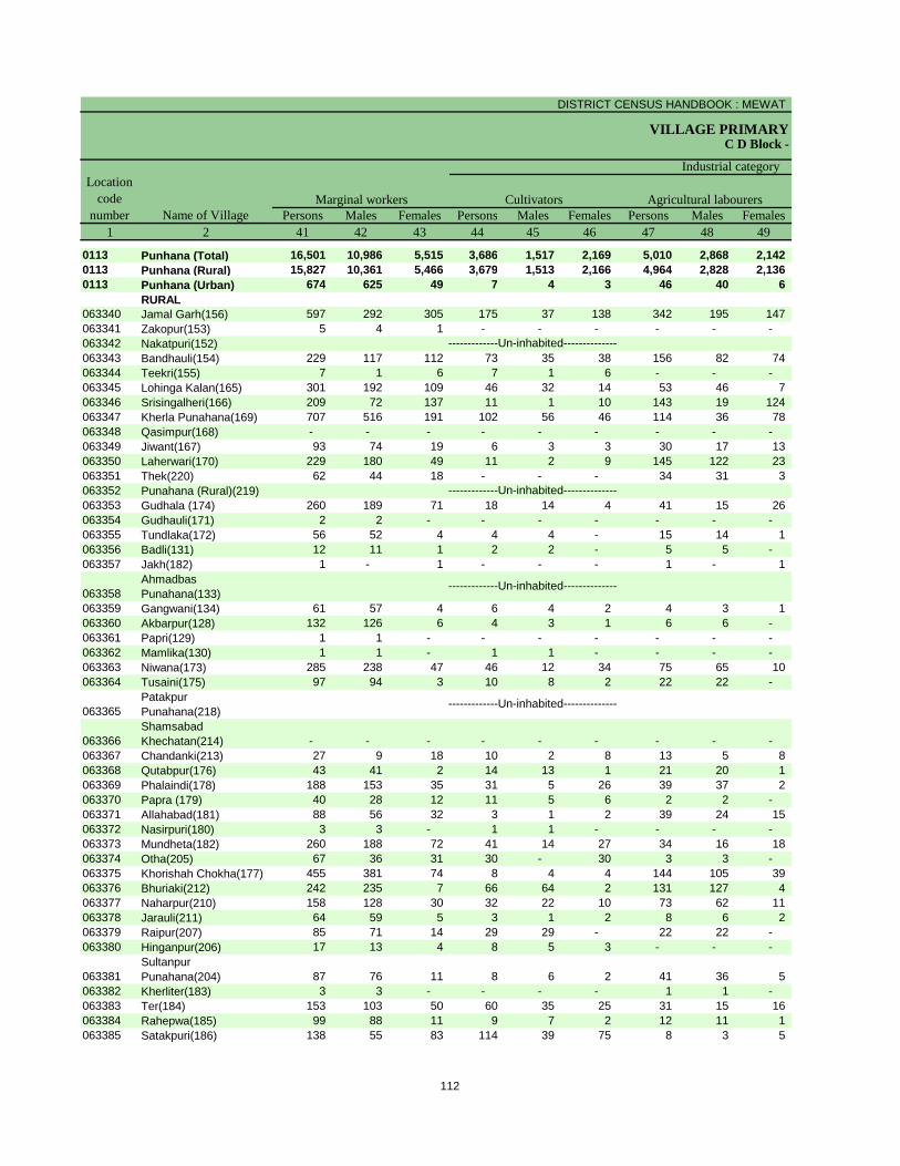
DISTRICT CENSUS HANDBOOK : MEWAT
VILLAGE PRIMARYC D Block -
Persons Males Females Persons Males Females Persons Males Females1 2 41 42 43 44 45 46 47 48 49
0113 Punhana (Total) 16,501 10,986 5,515 3,686 1,517 2,169 5,010 2,868 2,142 0113 Punhana (Rural) 15,827 10,361 5,466 3,679 1,513 2,166 4,964 2,828 2,136 0113 Punhana (Urban) 674 625 49 7 4 3 46 40 6
RURAL063340 Jamal Garh(156) 597 292 305 175 37 138 342 195 147 063341 Zakopur(153) 5 4 1 - - - - - - 063342 Nakatpuri(152)063343 Bandhauli(154) 229 117 112 73 35 38 156 82 74 063344 Teekri(155) 7 1 6 7 1 6 - - - 063345 Lohinga Kalan(165) 301 192 109 46 32 14 53 46 7 063346 Srisingalheri(166) 209 72 137 11 1 10 143 19 124 063347 Kherla Punahana(169) 707 516 191 102 56 46 114 36 78 063348 Qasimpur(168) - - - - - - - - - 063349 Jiwant(167) 93 74 19 6 3 3 30 17 13 063350 Laherwari(170) 229 180 49 11 2 9 145 122 23 063351 Thek(220) 62 44 18 - - - 34 31 3 063352 Punahana (Rural)(219)063353 Gudhala (174) 260 189 71 18 14 4 41 15 26 063354 Gudhauli(171) 2 2 - - - - - - - 063355 Tundlaka(172) 56 52 4 4 4 - 15 14 1 063356 Badli(131) 12 11 1 2 2 - 5 5 - 063357 Jakh(182) 1 - 1 - - - 1 - 1
063358Ahmadbas Punahana(133)
063359 Gangwani(134) 61 57 4 6 4 2 4 3 1 063360 Akbarpur(128) 132 126 6 4 3 1 6 6 - 063361 Papri(129) 1 1 - - - - - - - 063362 Mamlika(130) 1 1 - 1 1 - - - - 063363 Niwana(173) 285 238 47 46 12 34 75 65 10 063364 Tusaini(175) 97 94 3 10 8 2 22 22 -
063365Patakpur Punahana(218)
063366Shamsabad Khechatan(214) - - - - - - - - -
063367 Chandanki(213) 27 9 18 10 2 8 13 5 8 063368 Qutabpur(176) 43 41 2 14 13 1 21 20 1 063369 Phalaindi(178) 188 153 35 31 5 26 39 37 2 063370 Papra (179) 40 28 12 11 5 6 2 2 - 063371 Allahabad(181) 88 56 32 3 1 2 39 24 15 063372 Nasirpuri(180) 3 3 - 1 1 - - - - 063373 Mundheta(182) 260 188 72 41 14 27 34 16 18 063374 Otha(205) 67 36 31 30 - 30 3 3 - 063375 Khorishah Chokha(177) 455 381 74 8 4 4 144 105 39 063376 Bhuriaki(212) 242 235 7 66 64 2 131 127 4 063377 Naharpur(210) 158 128 30 32 22 10 73 62 11 063378 Jarauli(211) 64 59 5 3 1 2 8 6 2 063379 Raipur(207) 85 71 14 29 29 - 22 22 - 063380 Hinganpur(206) 17 13 4 8 5 3 - - -
063381Sultanpur Punahana(204) 87 76 11 8 6 2 41 36 5
063382 Kherliter(183) 3 3 - - - - 1 1 - 063383 Ter(184) 153 103 50 60 35 25 31 15 16 063384 Rahepwa(185) 99 88 11 9 7 2 12 11 1 063385 Satakpuri(186) 138 55 83 114 39 75 8 3 5
Name of VillageMarginal workers Cultivators Agricultural labourers
Industrial category Location
code number
-------------Un-inhabited--------------
-------------Un-inhabited--------------
-------------Un-inhabited--------------
-------------Un-inhabited--------------
112
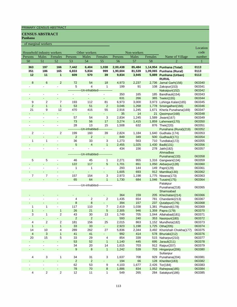
PRIMARY CENSUS ABSTRACT
CENSUS ABSTRACTPunhana
Persons Males Females Persons Males Females Persons Males Females50 51 52 53 54 55 56 57 58 2 1
363 197 166 7,442 6,404 1,038 2,00,438 85,484 1,14,954 Punhana (Total) 0113351 186 165 6,833 5,834 999 1,90,604 81,539 1,09,065 Punhana (Rural) 011312 11 1 609 570 39 9,834 3,945 5,889 Punhana (Urban) 0113
RURAL8 6 2 72 54 18 4,973 2,237 2,736 Jamal Garh(156) 063340
- - - 5 4 1 199 91 108 Zakopur(153) 063341Nakatpuri(152) 063342
- - - - - - 350 165 185 Bandhauli(154) 063343- - - - - - 631 266 365 Teekri(155) 063344
9 2 7 193 112 81 6,973 3,000 3,973 Lohinga Kalan(165) 0633452 1 1 53 51 2 3,046 1,268 1,778 Srisingalheri(166) 063346
21 9 12 470 415 55 2,916 1,245 1,671 Kherla Punahana(169) 063347- - - - - - 35 14 21 Qasimpur(168) 063348- - - 57 54 3 2,834 1,245 1,589 Jiwant(167) 063349- - - 73 56 17 3,274 1,415 1,859 Laherwari(170) 063350- - - 28 13 15 1,508 632 876 Thek(220) 063351
Punahana (Rural)(219) 0633522 - 2 199 160 39 2,824 1,184 1,640 Gudhala (174) 063353
- - - 2 2 - 849 349 500 Gudhauli(171) 0633541 1 - 36 33 3 1,273 563 710 Tundlaka(172) 063355
- - - 5 4 1 2,455 1,025 1,430 Badli(131) 063356- - - - - - 434 156 278 Jakh(182) 063357
Ahmadbas Punahana(133) 063358
5 5 - 46 45 1 2,271 955 1,316 Gangwani(134) 063359- - - 122 117 5 1,701 651 1,050 Akbarpur(128) 063360- - - 1 1 - 293 144 149 Papri(129) 063361- - - - - - 1,605 693 912 Mamlika(130) 063362
7 7 - 157 154 3 2,973 1,198 1,775 Niwana(173) 063363- - - 65 64 1 1,730 684 1,046 Tusaini(175) 063364
Patakpur Punahana(218) 063365
- - - - - - 364 159 205 Shamsabad Khechatan(214) 063366
- - - 4 2 2 1,435 654 781 Chandanki(213) 063367- - - 8 8 - 394 157 237 Qutabpur(176) 063368
1 1 - 117 110 7 2,419 1,038 1,381 Phalaindi(178) 0633691 - 1 26 21 5 2,305 946 1,359 Papra (179) 0633703 1 2 43 30 13 1,749 705 1,044 Allahabad(181) 063371
- - - 2 2 - 593 240 353 Nasirpuri(180) 0633724 2 2 181 156 25 2,015 863 1,152 Mundheta(182) 0633731 - 1 33 33 - 2,923 1,198 1,725 Otha(205) 063374
14 10 4 289 262 27 5,836 2,344 3,492 Khorishah Chokha(177) 0633754 3 1 41 41 - 992 414 578 Bhuriaki(212) 063376
20 15 5 33 29 4 854 339 515 Naharpur(210) 063377- - - 53 52 1 1,140 445 695 Jarauli(211) 063378- - - 34 20 14 1,615 703 912 Raipur(207) 063379- - - 9 8 1 1,242 539 703 Hinganpur(206) 063380
4 3 1 34 31 3 1,637 708 929 Sultanpur Punahana(204) 063381
- - - 2 2 - 194 66 128 Kherliter(183) 063382- - - 62 53 9 4,103 1,677 2,426 Ter(184) 063383- - - 78 70 8 1,886 834 1,052 Rahepwa(185) 063384
4 2 2 12 11 1 549 265 284 Satakpuri(186) 063385
Location code
numberHousehold industry workers
Name of VillageOther workers Non-workers
of marginal workers
-------------Un-inhabited--------------
-------------Un-inhabited--------------
-------------Un-inhabited--------------
-------------Un-inhabited--------------
113
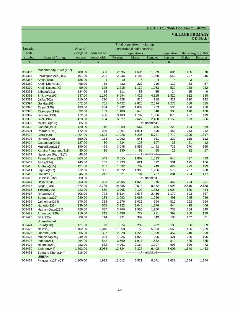
DISTRICT CENSUS HANDBOOK : MEWAT
VILLAGE PRIMARY
Persons Males Females Persons Males Females1 2 3 4 5 6 7 8 9 10
Name of Village
Location code
number
Total population (including institutional and houseless
population)Area of
Village in hectares
Number of households
C D Block -
Population in the age-group 0-6
063386 Mohammadpur Ter (187) 180.00 393 2,995 1,606 1,389 805 435 370 063387 Ferozepur Meo(203) 191.00 282 2,246 1,186 1,060 542 297 245 063388 Amka(188) 185.00 1 10 6 4 4 3 1 063389 Khajli Khurd(189) 68.00 58 432 222 210 110 53 57 063390 Khajli Kalan(190) 90.00 325 2,215 1,132 1,083 520 258 262 063391 Bilhaka(191) 184.00 15 111 56 55 24 15 9 063392 Shikrawa(192) 937.00 1,176 8,544 4,429 4,115 1,820 922 898 063393 Jalika(202) 110.00 220 1,528 810 718 322 180 142 063394 Gulalta(201) 672.00 781 5,422 2,828 2,594 1,273 658 615 063395 Rajpur(195) 133.00 264 1,992 1,039 953 536 286 250 063396 Rasoolpur(194) 92.00 189 1,188 640 548 300 170 130 063397 Jehtana(193) 172.00 458 3,403 1,797 1,606 876 457 419 063398 Siroli(196) 423.00 704 5,027 2,627 2,400 1,159 593 566 063399 Milakpuri(200) 85.00063400 Gubradi(197) 120.00 149 1,009 544 465 223 124 99 063401 Phardari(198) 172.00 290 1,907 1,011 896 455 243 212 063402 Bisru(199) 1,094.00 1,623 11,926 6,205 5,721 2,712 1,395 1,317 063403 Runera(208) 150.00 153 1,092 541 551 230 118 112 063404 Gabanspur(209) 127.00 30 234 127 107 33 21 12 063405 Mubarikpur(216) 390.00 423 3,048 1,556 1,492 735 370 365 063406 Karaira Punahana(215) 35.00 16 130 62 68 29 12 17 063407 Nakanpur (Part)(217) 48.00063408 Paima Khera(233) 363.00 549 3,555 1,862 1,693 840 427 413 063409 Barka(234) 145.00 162 1,233 621 612 331 175 156 063410 Andhaki(235) 131.00 207 1,532 789 743 422 223 199 063411 Laphuri(237) 212.00 385 2,622 1,366 1,256 575 287 288 063412 Ghira(236) 345.00 217 1,521 794 727 381 204 177 063413 Basdalla(232) 200.00063414 Hajipur(231) 263.00 293 2,005 1,029 976 455 224 231 063415 Singar(238) 1,572.00 2,785 19,885 10,513 9,372 4,698 2,510 2,188 063416 Tirwara(230) 423.00 550 3,965 2,102 1,863 1,004 520 484 063417 Dadauli(221) 708.00 728 5,114 2,678 2,436 1,170 603 567 063418 Sumahra(222) 280.00 288 2,093 1,067 1,026 491 245 246 063419 Jakhokhar(224) 176.00 313 1,976 1,022 954 516 252 264 063420 Naheda(223) 339.00 565 3,822 2,046 1,776 844 438 406 063421 Hathan Gaon(227) 728.00 537 3,706 1,956 1,750 733 384 349 063422 Aminabad(226) 116.00 212 1,438 727 711 399 200 199 063423 Bikti(225) 80.00 114 731 382 349 183 102 81
063424Shamshabad Khurd(228) 121.00 79 574 282 292 135 66 69
063425 Nai(229) 1,102.00 1,818 11,658 6,155 5,503 2,665 1,406 1,259 063426 Jharokri(239) 266.00 327 2,328 1,229 1,099 457 248 209 063427 Mhuziaba(240) 249.00 261 1,925 1,020 905 421 226 195 063428 Indana(241) 264.00 542 3,599 1,917 1,682 810 425 385 063429 Neemka(242) 422.00 582 4,061 2,154 1,907 998 526 472 063430 Bichhor(243) 1,692.00 2,033 13,824 7,326 6,498 3,003 1,540 1,463 063431 Samand Khera(244) 118.00
URBAN063432 Pingwan (127) (CT) 1,800.00 1,982 12,612 6,521 6,091 2,628 1,354 1,274
-------------Un-inhabited--------------
-------------Un-inhabited--------------
-------------Un-inhabited--------------
-------------Un-inhabited--------------
114
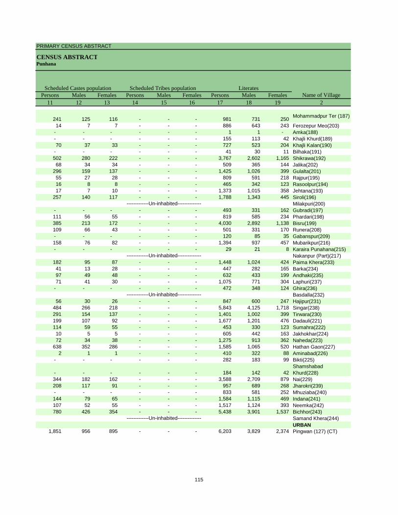
PRIMARY CENSUS ABSTRACT
CENSUS ABSTRACTPunhana
Persons Males Females Persons Males Females Persons Males Females11 12 13 14 15 16 17 18 19 2
Name of VillageLiteratesScheduled Castes population Scheduled Tribes population
241 125 116 - - - 981 731 250 Mohammadpur Ter (187)
14 7 7 - - - 886 643 243 Ferozepur Meo(203)- - - - - - 1 1 - Amka(188)- - - - - - 155 113 42 Khajli Khurd(189)70 37 33 - - - 727 523 204 Khajli Kalan(190)
- - - - - - 41 30 11 Bilhaka(191)502 280 222 - - - 3,767 2,602 1,165 Shikrawa(192)68 34 34 - - - 509 365 144 Jalika(202)
296 159 137 - - - 1,425 1,026 399 Gulalta(201)55 27 28 - - - 809 591 218 Rajpur(195)16 8 8 - - - 465 342 123 Rasoolpur(194)17 7 10 - - - 1,373 1,015 358 Jehtana(193)
257 140 117 - - - 1,788 1,343 445 Siroli(196)Milakpuri(200)
- - - - - - 493 331 162 Gubradi(197)111 56 55 - - - 819 585 234 Phardari(198)385 213 172 - - - 4,030 2,892 1,138 Bisru(199)109 66 43 - - - 501 331 170 Runera(208)- - - - - - 120 85 35 Gabanspur(209)158 76 82 - - - 1,394 937 457 Mubarikpur(216)- - - - - - 29 21 8 Karaira Punahana(215)
Nakanpur (Part)(217)182 95 87 - - - 1,448 1,024 424 Paima Khera(233)41 13 28 - - - 447 282 165 Barka(234)97 49 48 - - - 632 433 199 Andhaki(235)71 41 30 - - - 1,075 771 304 Laphuri(237)
- - - - - - 472 348 124 Ghira(236)Basdalla(232)
56 30 26 - - - 847 600 247 Hajipur(231)484 266 218 - - - 5,843 4,125 1,718 Singar(238)291 154 137 - - - 1,401 1,002 399 Tirwara(230)199 107 92 - - - 1,677 1,201 476 Dadauli(221)114 59 55 - - - 453 330 123 Sumahra(222)10 5 5 - - - 605 442 163 Jakhokhar(224)72 34 38 - - - 1,275 913 362 Naheda(223)
638 352 286 - - - 1,585 1,065 520 Hathan Gaon(227)2 1 1 - - - 410 322 88 Aminabad(226)
- - - - - - 282 183 99 Bikti(225)
- - - - - - 184 142 42 Shamshabad Khurd(228)
344 182 162 - - - 3,588 2,709 879 Nai(229)208 117 91 - - - 957 689 268 Jharokri(239)- - - - - - 833 581 252 Mhuziaba(240)144 79 65 - - - 1,584 1,115 469 Indana(241)107 52 55 - - - 1,517 1,124 393 Neemka(242)780 426 354 - - - 5,438 3,901 1,537 Bichhor(243)
Samand Khera(244)URBAN
1,851 956 895 - - - 6,203 3,829 2,374 Pingwan (127) (CT)
-------------Un-inhabited--------------
-------------Un-inhabited--------------
-------------Un-inhabited--------------
-------------Un-inhabited--------------
115
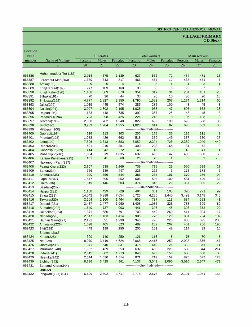
DISTRICT CENSUS HANDBOOK : MEWAT
VILLAGE PRIMARYC D Block -
Persons Males Females Persons Males Females Persons Males Females1 2 20 21 22 23 24 25 26 27 28
Name of Village
Location code
numberIlliterates Total workers Main workers
063386 Mohammadpur Ter (187) 2,014 875 1,139 627 555 72 484 471 13 063387 Ferozepur Meo(203) 1,360 543 817 466 454 12 458 451 7 063388 Amka(188) 9 5 4 4 3 1 4 3 1 063389 Khajli Khurd(189) 277 109 168 93 88 5 92 87 5 063390 Khajli Kalan(190) 1,488 609 879 351 317 34 201 181 20 063391 Bilhaka(191) 70 26 44 30 20 10 30 20 10 063392 Shikrawa(192) 4,777 1,827 2,950 1,790 1,582 208 1,274 1,214 60 063393 Jalika(202) 1,019 445 574 385 285 100 48 45 3 063394 Gulalta(201) 3,997 1,802 2,195 1,035 988 47 696 668 28 063395 Rajpur(195) 1,183 448 735 392 367 25 48 45 3 063396 Rasoolpur(194) 723 298 425 226 218 8 196 188 8 063397 Jehtana(193) 2,030 782 1,248 822 692 130 623 588 35 063398 Siroli(196) 3,239 1,284 1,955 1,028 941 87 695 659 36 063399 Milakpuri(200)063400 Gubradi(197) 516 213 303 200 165 35 119 111 8 063401 Phardari(198) 1,088 426 662 518 369 149 357 330 27 063402 Bisru(199) 7,896 3,313 4,583 3,052 2,324 728 2,389 1,940 449 063403 Runera(208) 591 210 381 403 238 165 81 72 9 063404 Gabanspur(209) 114 42 72 45 42 3 42 41 1 063405 Mubarikpur(216) 1,654 619 1,035 637 495 142 403 350 53 063406 Karaira Punahana(215) 101 41 60 26 25 1 3 3 - 063407 Nakanpur (Part)(217)063408 Paima Khera(233) 2,107 838 1,269 738 715 23 560 538 22 063409 Barka(234) 786 339 447 228 222 6 178 173 5 063410 Andhaki(235) 900 356 544 386 285 101 370 276 94 063411 Laphuri(237) 1,547 595 952 605 505 100 484 429 55 063412 Ghira(236) 1,049 446 603 374 345 29 357 335 22 063413 Basdalla(232)063414 Hajipur(231) 1,158 429 729 484 381 103 370 271 99 063415 Singar(238) 14,042 6,388 7,654 5,725 4,285 1,440 3,493 3,148 345 063416 Tirwara(230) 2,564 1,100 1,464 900 787 113 634 593 41 063417 Dadauli(221) 3,437 1,477 1,960 1,408 1,085 323 788 699 89 063418 Sumahra(222) 1,640 737 903 441 396 45 393 373 20 063419 Jakhokhar(224) 1,371 580 791 709 449 260 411 394 17 063420 Naheda(223) 2,547 1,133 1,414 905 776 129 831 724 107 063421 Hathan Gaon(227) 2,121 891 1,230 946 726 220 903 695 208 063422 Aminabad(226) 1,028 405 623 489 282 207 451 256 195 063423 Bikti(225) 449 199 250 200 151 49 114 98 16
063424Shamshabad Khurd(228) 390 140 250 121 116 5 75 70 5
063425 Nai(229) 8,070 3,446 4,624 2,668 2,415 253 2,023 1,876 147 063426 Jharokri(239) 1,371 540 831 475 449 26 382 371 11 063427 Mhuziaba(240) 1,092 439 653 632 403 229 558 344 214 063428 Indana(241) 2,015 802 1,213 846 693 153 688 650 38 063429 Neemka(242) 2,544 1,030 1,514 871 719 152 825 697 128 063430 Bichhor(243) 8,386 3,425 4,961 4,133 3,043 1,090 3,020 2,547 473 063431 Samand Khera(244)
URBAN063432 Pingwan (127) (CT) 6,409 2,692 3,717 2,778 2,576 202 2,104 1,951 153
-------------Un-inhabited--------------
-------------Un-inhabited--------------
-------------Un-inhabited--------------
-------------Un-inhabited--------------
116

PRIMARY CENSUS ABSTRACT
CENSUS ABSTRACTPunhana
Persons Males Females Persons Males Females PersonsMalesFemales Persons Males Females29 30 31 32 33 34 35 36 37 38 39 40 2
CultivatorsName of Village
Household industry workersAgricultural labourers
Industrial category of main workers
Other workers
145 139 6 77 73 4 - - - 262 259 3 Mohammadpur Ter (187)
145 142 3 1 1 - 2 2 - 310 306 4 Ferozepur Meo(203)1 - 1 - - - - - - 3 3 - Amka(188)
23 22 1 37 34 3 - - - 32 31 1 Khajli Khurd(189)79 70 9 36 33 3 2 2 - 84 76 8 Khajli Kalan(190)12 11 1 1 1 - - - - 17 8 9 Bilhaka(191)
475 446 29 72 69 3 9 8 1 718 691 27 Shikrawa(192)1 1 - 1 1 - 1 1 - 45 42 3 Jalika(202)
410 399 11 160 151 9 9 8 1 117 110 7 Gulalta(201)22 21 1 2 1 1 - - - 24 23 1 Rajpur(195)75 71 4 48 45 3 2 2 - 71 70 1 Rasoolpur(194)
244 217 27 19 17 2 11 11 - 349 343 6 Jehtana(193)335 320 15 50 39 11 2 2 - 308 298 10 Siroli(196)
Milakpuri(200)62 57 5 5 5 - - - - 52 49 3 Gubradi(197)
108 101 7 40 36 4 17 17 - 192 176 16 Phardari(198)1,260 880 380 233 213 20 21 16 5 875 831 44 Bisru(199)
33 29 4 3 3 - - - - 45 40 5 Runera(208)18 17 1 19 19 - - - - 5 5 - Gabanspur(209)
139 104 35 9 8 1 4 4 - 251 234 17 Mubarikpur(216)2 2 - - - - - - - 1 1 - Karaira Punahana(215)
Nakanpur (Part)(217)254 251 3 7 7 - 15 12 3 284 268 16 Paima Khera(233)
8 8 - 50 47 3 1 1 - 119 117 2 Barka(234)93 75 18 204 145 59 2 1 1 71 55 16 Andhaki(235)
129 116 13 48 37 11 5 5 - 302 271 31 Laphuri(237)134 128 6 8 6 2 5 5 - 210 196 14 Ghira(236)
Basdalla(232)246 153 93 49 49 - 9 6 3 66 63 3 Hajipur(231)
1,741 1,546 195 230 182 48 71 56 15 1,451 1,364 87 Singar(238)297 282 15 17 13 4 9 8 1 311 290 21 Tirwara(230)336 296 40 107 93 14 12 12 - 333 298 35 Dadauli(221)257 242 15 18 17 1 13 12 1 105 102 3 Sumahra(222)200 191 9 11 10 1 1 1 - 199 192 7 Jakhokhar(224)446 361 85 21 19 2 1 1 - 363 343 20 Naheda(223)613 464 149 242 184 58 4 3 1 44 44 - Hathan Gaon(227)115 103 12 22 14 8 1 - 1 313 139 174 Aminabad(226)63 51 12 4 3 1 - - - 47 44 3 Bikti(225)
54 50 4 9 8 1 - - - 12 12 - Shamshabad Khurd(228)
1,055 1,030 25 236 224 12 27 5 22 705 617 88 Nai(229)239 230 9 64 62 2 7 7 - 72 72 - Jharokri(239)99 92 7 18 16 2 6 3 3 435 233 202 Mhuziaba(240)
259 242 17 16 11 5 17 14 3 396 383 13 Indana(241)333 303 30 42 24 18 56 28 28 394 342 52 Neemka(242)
1,202 1,055 147 523 376 147 24 19 5 1,271 1,097 174 Bichhor(243)Samand Khera(244)URBAN
244 235 9 197 178 19 92 90 2 1,571 1,448 123 Pingwan (127) (CT)
-------------Un-inhabited--------------
-------------Un-inhabited--------------
-------------Un-inhabited--------------
-------------Un-inhabited--------------
117
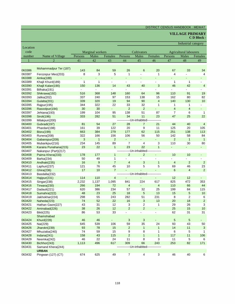
DISTRICT CENSUS HANDBOOK : MEWAT
VILLAGE PRIMARYC D Block -
Persons Males Females Persons Males Females Persons Males Females1 2 41 42 43 44 45 46 47 48 49
Name of VillageMarginal workers Cultivators Agricultural labourers
Industrial category Location
code number
063386 Mohammadpur Ter (187) 143 84 59 26 6 20 67 33 34 063387 Ferozepur Meo(203) 8 3 5 1 - 1 4 - 4 063388 Amka(188) - - - - - - - - - 063389 Khajli Khurd(189) 1 1 - - - - 1 1 - 063390 Khajli Kalan(190) 150 136 14 43 40 3 46 42 4 063391 Bilhaka(191) - - - - - - - - - 063392 Shikrawa(192) 516 368 148 160 64 96 110 91 19 063393 Jalika(202) 337 240 97 153 138 15 162 80 82 063394 Gulalta(201) 339 320 19 94 90 4 140 130 10 063395 Rajpur(195) 344 322 22 33 32 1 1 1 - 063396 Rasoolpur(194) 30 30 - 2 2 - 4 4 - 063397 Jehtana(193) 199 104 95 138 51 87 7 6 1 063398 Siroli(196) 333 282 51 34 11 23 47 25 22 063399 Milakpuri(200)063400 Gubradi(197) 81 54 27 28 7 21 44 40 4 063401 Phardari(198) 161 39 122 20 9 11 125 20 105 063402 Bisru(199) 663 384 279 177 62 115 251 138 113 063403 Runera(208) 322 166 156 106 56 50 142 58 84 063404 Gabanspur(209) 3 1 2 - - - 2 1 1 063405 Mubarikpur(216) 234 145 89 7 4 3 110 30 80 063406 Karaira Punahana(215) 23 22 1 23 22 1 - - - 063407 Nakanpur (Part)(217)063408 Paima Khera(233) 178 177 1 2 2 - 10 10 - 063409 Barka(234) 50 49 1 - - - - - - 063410 Andhaki(235) 16 9 7 4 3 1 4 2 2 063411 Laphuri(237) 121 76 45 10 5 5 69 46 23 063412 Ghira(236) 17 10 7 - - - 6 4 2 063413 Basdalla(232)063414 Hajipur(231) 114 110 4 - - - 12 12 - 063415 Singar(238) 2,232 1,137 1,095 841 224 617 825 472 353 063416 Tirwara(230) 266 194 72 4 - 4 110 66 44 063417 Dadauli(221) 620 386 234 57 32 25 199 84 115 063418 Sumahra(222) 48 23 25 18 5 13 15 5 10 063419 Jakhokhar(224) 298 55 243 282 51 231 8 2 6 063420 Naheda(223) 74 52 22 16 3 13 20 18 2 063421 Hathan Gaon(227) 43 31 12 3 2 1 29 26 3 063422 Aminabad(226) 38 26 12 2 2 - 25 15 10 063423 Bikti(225) 86 53 33 - - - 62 31 31
063424Shamshabad Khurd(228) 46 46 - 3 3 - 5 5 -
063425 Nai(229) 645 539 106 59 35 24 93 43 50 063426 Jharokri(239) 93 78 15 2 1 1 14 11 3 063427 Mhuziaba(240) 74 59 15 9 8 1 6 5 1 063428 Indana(241) 158 43 115 2 1 1 117 11 106 063429 Neemka(242) 46 22 24 11 8 3 11 5 6 063430 Bichhor(243) 1,113 496 617 309 66 243 253 82 171 063431 Samand Khera(244)
URBAN063432 Pingwan (127) (CT) 674 625 49 7 4 3 46 40 6
-------------Un-inhabited--------------
-------------Un-inhabited--------------
-------------Un-inhabited--------------
-------------Un-inhabited--------------
118
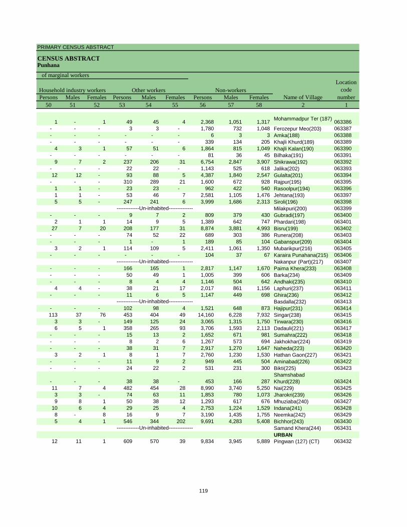
PRIMARY CENSUS ABSTRACT
CENSUS ABSTRACTPunhana
Persons Males Females Persons Males Females Persons Males Females50 51 52 53 54 55 56 57 58 2 1
Location code
numberHousehold industry workers
Name of VillageOther workers Non-workers
of marginal workers
1 - 1 49 45 4 2,368 1,051 1,317 Mohammadpur Ter (187) 063386- - - 3 3 - 1,780 732 1,048 Ferozepur Meo(203) 063387- - - - - - 6 3 3 Amka(188) 063388- - - - - - 339 134 205 Khajli Khurd(189) 063389
4 3 1 57 51 6 1,864 815 1,049 Khajli Kalan(190) 063390- - - - - - 81 36 45 Bilhaka(191) 063391
9 7 2 237 206 31 6,754 2,847 3,907 Shikrawa(192) 063392- - - 22 22 - 1,143 525 618 Jalika(202) 06339312 12 - 93 88 5 4,387 1,840 2,547 Gulalta(201) 063394
- - - 310 289 21 1,600 672 928 Rajpur(195) 0633951 1 - 23 23 - 962 422 540 Rasoolpur(194) 0633961 1 - 53 46 7 2,581 1,105 1,476 Jehtana(193) 0633975 5 - 247 241 6 3,999 1,686 2,313 Siroli(196) 063398
Milakpuri(200) 063399- - - 9 7 2 809 379 430 Gubradi(197) 063400
2 1 1 14 9 5 1,389 642 747 Phardari(198) 06340127 7 20 208 177 31 8,874 3,881 4,993 Bisru(199) 063402
- - - 74 52 22 689 303 386 Runera(208) 063403- - - 1 - 1 189 85 104 Gabanspur(209) 063404
3 2 1 114 109 5 2,411 1,061 1,350 Mubarikpur(216) 063405- - - - - - 104 37 67 Karaira Punahana(215) 063406
Nakanpur (Part)(217) 063407- - - 166 165 1 2,817 1,147 1,670 Paima Khera(233) 063408- - - 50 49 1 1,005 399 606 Barka(234) 063409- - - 8 4 4 1,146 504 642 Andhaki(235) 063410
4 4 - 38 21 17 2,017 861 1,156 Laphuri(237) 063411- - - 11 6 5 1,147 449 698 Ghira(236) 063412
Basdalla(232) 063413- - - 102 98 4 1,521 648 873 Hajipur(231) 063414113 37 76 453 404 49 14,160 6,228 7,932 Singar(238) 063415
3 3 - 149 125 24 3,065 1,315 1,750 Tirwara(230) 0634166 5 1 358 265 93 3,706 1,593 2,113 Dadauli(221) 063417
- - - 15 13 2 1,652 671 981 Sumahra(222) 063418- - - 8 2 6 1,267 573 694 Jakhokhar(224) 063419- - - 38 31 7 2,917 1,270 1,647 Naheda(223) 063420
3 2 1 8 1 7 2,760 1,230 1,530 Hathan Gaon(227) 063421- - - 11 9 2 949 445 504 Aminabad(226) 063422- - - 24 22 2 531 231 300 Bikti(225) 063423
- - - 38 38 - 453 166 287 Shamshabad Khurd(228) 063424
11 7 4 482 454 28 8,990 3,740 5,250 Nai(229) 0634253 3 - 74 63 11 1,853 780 1,073 Jharokri(239) 0634269 8 1 50 38 12 1,293 617 676 Mhuziaba(240) 063427
10 6 4 29 25 4 2,753 1,224 1,529 Indana(241) 0634288 - 8 16 9 7 3,190 1,435 1,755 Neemka(242) 0634295 4 1 546 344 202 9,691 4,283 5,408 Bichhor(243) 063430
Samand Khera(244) 063431URBAN
12 11 1 609 570 39 9,834 3,945 5,889 Pingwan (127) (CT) 063432
-------------Un-inhabited--------------
-------------Un-inhabited--------------
-------------Un-inhabited--------------
-------------Un-inhabited--------------
119

Urban PCA-Town wise Primary Census Abstract
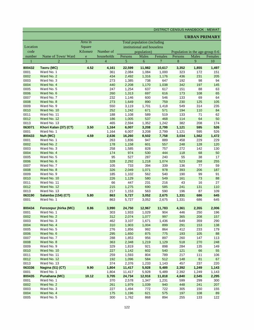
DISTRICT CENSUS HANDBOOK : MEWAT
URBAN PRIMARY
Persons Males Females Persons Males Females1 2 3 4 5 6 7 8 9 10
800432 Taoru (MC) 4.52 4,161 22,599 11,982 10,617 3,352 1,855 1,497 0001 Ward No. 1 361 2,084 1,084 1,000 323 172 151 0002 Ward No. 2 434 2,492 1,316 1,176 436 231 205 0003 Ward No. 3 273 1,385 738 647 192 98 94 0004 Ward No. 4 440 2,208 1,170 1,038 342 197 145 0005 Ward No. 5 247 1,254 637 617 151 88 63 0006 Ward No. 6 260 1,313 697 616 173 108 65 0007 Ward No. 7 232 1,146 600 546 133 69 64 0008 Ward No. 8 273 1,649 890 759 230 125 105 0009 Ward No. 9 550 3,119 1,701 1,418 549 314 235 0010 Ward No. 10 252 1,242 671 571 194 110 84 0011 Ward No. 11 188 1,108 589 519 133 71 62 0012 Ward No. 12 186 1,005 537 468 114 64 50 0013 Ward No. 13 465 2,594 1,352 1,242 382 208 174 063071 Khori Kalan (37) (CT) 3.50 1,164 6,007 3,208 2,799 1,121 595 526 0001 Ward No. 1 1,164 6,007 3,208 2,799 1,121 595 526 800433 Nuh (MC) 4.59 2,636 16,260 8,502 7,758 3,034 1,562 1,472 0001 Ward No. 1 263 1,836 947 889 458 229 229 0002 Ward No. 2 178 1,158 601 557 248 128 120 0003 Ward No. 3 258 1,585 828 757 272 142 130 0004 Ward No. 4 174 974 530 444 118 68 50 0005 Ward No. 5 95 527 287 240 55 38 17 0006 Ward No. 6 328 2,292 1,218 1,074 523 268 255 0007 Ward No. 7 105 733 394 339 136 77 59 0008 Ward No. 8 326 2,049 1,071 978 393 206 187 0009 Ward No. 9 185 1,102 562 540 190 99 91 0010 Ward No. 10 226 1,129 580 549 161 73 88 0011 Ward No. 11 66 447 231 216 43 16 27 0012 Ward No. 12 215 1,275 690 585 241 131 110 0013 Ward No. 13 217 1,153 563 590 196 87 109 063190 Salamba (154) (CT) 5.80 863 5,727 3,052 2,675 1,331 686 645 0001 Ward No. 1 863 5,727 3,052 2,675 1,331 686 645
800434 Ferozepur jhirka (MC) 8.86 3,990 24,750 12,967 11,783 4,361 2,355 2,006 0001 Ward No. 1 303 1,933 1,029 904 446 250 196 0002 Ward No. 2 312 2,074 1,077 997 365 208 157 0003 Ward No. 3 462 3,107 1,671 1,436 649 359 290 0004 Ward No. 4 310 1,903 1,004 899 291 153 138 0005 Ward No. 5 276 1,856 992 864 412 233 179 0006 Ward No. 6 295 1,650 875 775 193 105 88 0007 Ward No. 7 288 1,853 956 897 260 147 113 0008 Ward No. 8 363 2,348 1,219 1,129 518 270 248 0009 Ward No. 9 329 1,819 921 898 284 135 149 0010 Ward No. 10 227 1,142 602 540 121 66 55 0011 Ward No. 11 259 1,593 804 789 217 111 106 0012 Ward No. 12 192 1,096 584 512 148 81 67 0013 Ward No. 13 374 2,376 1,233 1,143 457 237 220 063336 Nagina (51) (CT) 9.90 1,804 11,417 5,928 5,489 2,392 1,249 1,143 0001 Ward No. 1 1,804 11,417 5,928 5,489 2,392 1,249 1,143 800435 Punahana (MC) 10.12 3,705 24,734 12,916 11,818 4,840 2,545 2,295 0001 Ward No. 1 370 2,578 1,347 1,231 599 299 300 0002 Ward No. 2 261 1,979 1,039 940 448 241 207 0003 Ward No. 3 227 1,494 772 722 305 150 155 0004 Ward No. 4 175 1,196 621 575 197 108 89 0005 Ward No. 5 300 1,762 868 894 255 133 122
Population in the age-group 0-6Name of Town/ Ward
Location code
number
Total population (including institutional and houseless
population)
Area in Square
Kilometre
Number of households
122
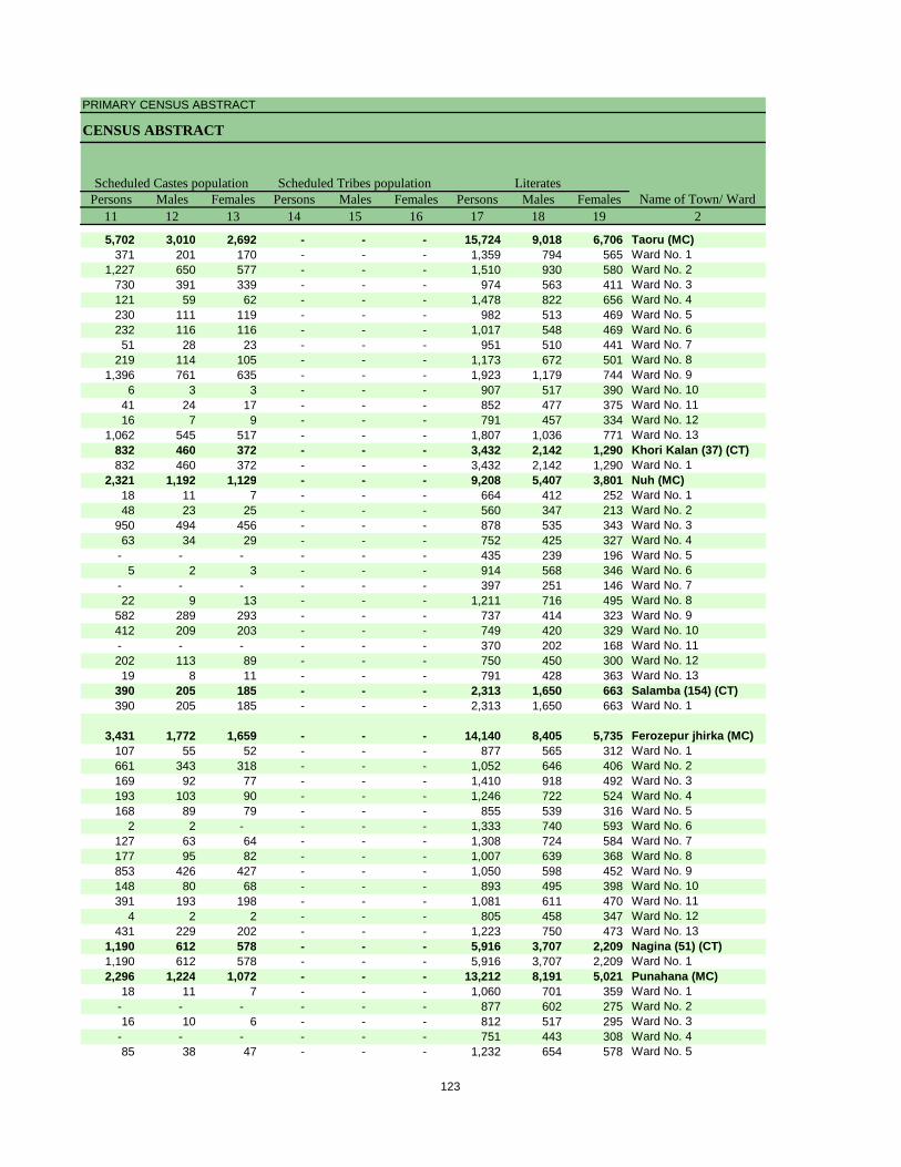
PRIMARY CENSUS ABSTRACT
CENSUS ABSTRACT
Persons Males Females Persons Males Females Persons Males Females11 12 13 14 15 16 17 18 19 2
5,702 3,010 2,692 - - - 15,724 9,018 6,706 Taoru (MC)371 201 170 - - - 1,359 794 565 Ward No. 1
1,227 650 577 - - - 1,510 930 580 Ward No. 2730 391 339 - - - 974 563 411 Ward No. 3121 59 62 - - - 1,478 822 656 Ward No. 4230 111 119 - - - 982 513 469 Ward No. 5232 116 116 - - - 1,017 548 469 Ward No. 651 28 23 - - - 951 510 441 Ward No. 7
219 114 105 - - - 1,173 672 501 Ward No. 81,396 761 635 - - - 1,923 1,179 744 Ward No. 9
6 3 3 - - - 907 517 390 Ward No. 1041 24 17 - - - 852 477 375 Ward No. 1116 7 9 - - - 791 457 334 Ward No. 12
1,062 545 517 - - - 1,807 1,036 771 Ward No. 13832 460 372 - - - 3,432 2,142 1,290 Khori Kalan (37) (CT)832 460 372 - - - 3,432 2,142 1,290 Ward No. 1
2,321 1,192 1,129 - - - 9,208 5,407 3,801 Nuh (MC)18 11 7 - - - 664 412 252 Ward No. 148 23 25 - - - 560 347 213 Ward No. 2
950 494 456 - - - 878 535 343 Ward No. 363 34 29 - - - 752 425 327 Ward No. 4
- - - - - - 435 239 196 Ward No. 55 2 3 - - - 914 568 346 Ward No. 6
- - - - - - 397 251 146 Ward No. 722 9 13 - - - 1,211 716 495 Ward No. 8
582 289 293 - - - 737 414 323 Ward No. 9412 209 203 - - - 749 420 329 Ward No. 10- - - - - - 370 202 168 Ward No. 11202 113 89 - - - 750 450 300 Ward No. 1219 8 11 - - - 791 428 363 Ward No. 13
390 205 185 - - - 2,313 1,650 663 Salamba (154) (CT)390 205 185 - - - 2,313 1,650 663 Ward No. 1
3,431 1,772 1,659 - - - 14,140 8,405 5,735 Ferozepur jhirka (MC)107 55 52 - - - 877 565 312 Ward No. 1661 343 318 - - - 1,052 646 406 Ward No. 2169 92 77 - - - 1,410 918 492 Ward No. 3193 103 90 - - - 1,246 722 524 Ward No. 4168 89 79 - - - 855 539 316 Ward No. 5
2 2 - - - - 1,333 740 593 Ward No. 6127 63 64 - - - 1,308 724 584 Ward No. 7177 95 82 - - - 1,007 639 368 Ward No. 8853 426 427 - - - 1,050 598 452 Ward No. 9148 80 68 - - - 893 495 398 Ward No. 10391 193 198 - - - 1,081 611 470 Ward No. 11
4 2 2 - - - 805 458 347 Ward No. 12431 229 202 - - - 1,223 750 473 Ward No. 13
1,190 612 578 - - - 5,916 3,707 2,209 Nagina (51) (CT)1,190 612 578 - - - 5,916 3,707 2,209 Ward No. 12,296 1,224 1,072 - - - 13,212 8,191 5,021 Punahana (MC)
18 11 7 - - - 1,060 701 359 Ward No. 1- - - - - - 877 602 275 Ward No. 216 10 6 - - - 812 517 295 Ward No. 3
- - - - - - 751 443 308 Ward No. 485 38 47 - - - 1,232 654 578 Ward No. 5
Scheduled Castes population Scheduled Tribes population LiteratesName of Town/ Ward
123
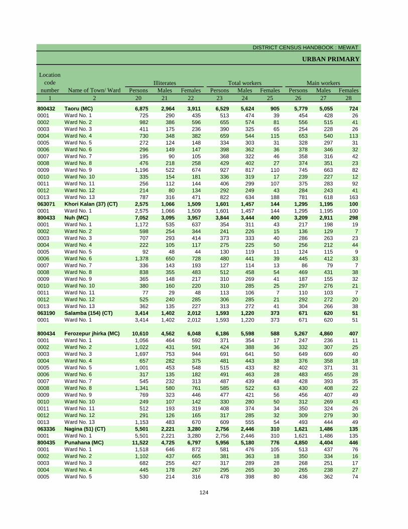
DISTRICT CENSUS HANDBOOK : MEWAT
URBAN PRIMARY
Persons Males Females Persons Males Females Persons Males Females1 2 20 21 22 23 24 25 26 27 28
800432 Taoru (MC) 6,875 2,964 3,911 6,529 5,624 905 5,779 5,055 724 0001 Ward No. 1 725 290 435 513 474 39 454 428 26 0002 Ward No. 2 982 386 596 655 574 81 556 515 41 0003 Ward No. 3 411 175 236 390 325 65 254 228 26 0004 Ward No. 4 730 348 382 659 544 115 653 540 113 0005 Ward No. 5 272 124 148 334 303 31 328 297 31 0006 Ward No. 6 296 149 147 398 362 36 378 346 32 0007 Ward No. 7 195 90 105 368 322 46 358 316 42 0008 Ward No. 8 476 218 258 429 402 27 374 351 23 0009 Ward No. 9 1,196 522 674 927 817 110 745 663 82 0010 Ward No. 10 335 154 181 336 319 17 239 227 12 0011 Ward No. 11 256 112 144 406 299 107 375 283 92 0012 Ward No. 12 214 80 134 292 249 43 284 243 41 0013 Ward No. 13 787 316 471 822 634 188 781 618 163 063071 Khori Kalan (37) (CT) 2,575 1,066 1,509 1,601 1,457 144 1,295 1,195 100 0001 Ward No. 1 2,575 1,066 1,509 1,601 1,457 144 1,295 1,195 100 800433 Nuh (MC) 7,052 3,095 3,957 3,844 3,444 400 3,209 2,911 298 0001 Ward No. 1 1,172 535 637 354 311 43 217 198 19 0002 Ward No. 2 598 254 344 241 226 15 136 129 7 0003 Ward No. 3 707 293 414 373 333 40 286 263 23 0004 Ward No. 4 222 105 117 275 225 50 256 212 44 0005 Ward No. 5 92 48 44 130 119 11 124 115 9 0006 Ward No. 6 1,378 650 728 480 441 39 445 412 33 0007 Ward No. 7 336 143 193 127 114 13 86 79 7 0008 Ward No. 8 838 355 483 512 458 54 469 431 38 0009 Ward No. 9 365 148 217 310 269 41 187 155 32 0010 Ward No. 10 380 160 220 310 285 25 297 276 21 0011 Ward No. 11 77 29 48 113 106 7 110 103 7 0012 Ward No. 12 525 240 285 306 285 21 292 272 20 0013 Ward No. 13 362 135 227 313 272 41 304 266 38 063190 Salamba (154) (CT) 3,414 1,402 2,012 1,593 1,220 373 671 620 51 0001 Ward No. 1 3,414 1,402 2,012 1,593 1,220 373 671 620 51
800434 Ferozepur jhirka (MC) 10,610 4,562 6,048 6,186 5,598 588 5,267 4,860 407 0001 Ward No. 1 1,056 464 592 371 354 17 247 236 11 0002 Ward No. 2 1,022 431 591 424 388 36 332 307 25 0003 Ward No. 3 1,697 753 944 691 641 50 649 609 40 0004 Ward No. 4 657 282 375 481 443 38 376 358 18 0005 Ward No. 5 1,001 453 548 515 433 82 402 371 31 0006 Ward No. 6 317 135 182 491 463 28 483 455 28 0007 Ward No. 7 545 232 313 487 439 48 428 393 35 0008 Ward No. 8 1,341 580 761 585 522 63 430 408 22 0009 Ward No. 9 769 323 446 477 421 56 456 407 49 0010 Ward No. 10 249 107 142 330 280 50 312 269 43 0011 Ward No. 11 512 193 319 408 374 34 350 324 26 0012 Ward No. 12 291 126 165 317 285 32 309 279 30 0013 Ward No. 13 1,153 483 670 609 555 54 493 444 49 063336 Nagina (51) (CT) 5,501 2,221 3,280 2,756 2,446 310 1,621 1,486 135 0001 Ward No. 1 5,501 2,221 3,280 2,756 2,446 310 1,621 1,486 135 800435 Punahana (MC) 11,522 4,725 6,797 5,956 5,180 776 4,850 4,404 446 0001 Ward No. 1 1,518 646 872 581 476 105 513 437 76 0002 Ward No. 2 1,102 437 665 381 363 18 350 334 16 0003 Ward No. 3 682 255 427 317 289 28 268 251 17 0004 Ward No. 4 445 178 267 295 265 30 265 238 27 0005 Ward No. 5 530 214 316 478 398 80 436 362 74
Illiterates Total workers Main workersName of Town/ Ward
Location code
number
124
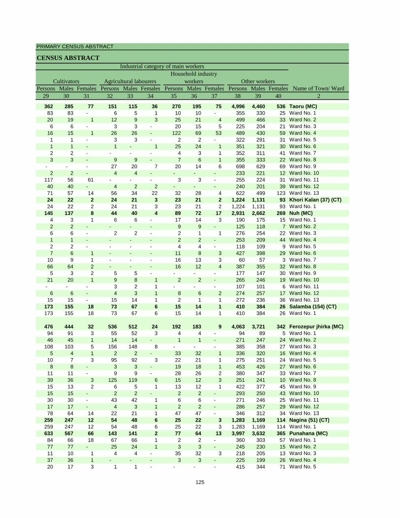
PRIMARY CENSUS ABSTRACT
CENSUS ABSTRACT
Persons Males Females Persons Males Females Persons Males Females Persons Males Females29 30 31 32 33 34 35 36 37 38 39 40 2
362 285 77 151 115 36 270 195 75 4,996 4,460 536 Taoru (MC)83 83 - 6 5 1 10 10 - 355 330 25 Ward No. 120 19 1 12 9 3 25 21 4 499 466 33 Ward No. 26 6 - 3 3 - 20 15 5 225 204 21 Ward No. 3
16 15 1 26 26 - 122 69 53 489 430 59 Ward No. 41 1 - 3 3 - 2 2 - 322 291 31 Ward No. 51 1 - 1 - 1 25 24 1 351 321 30 Ward No. 62 2 - - - - 4 3 1 352 311 41 Ward No. 73 3 - 9 9 - 7 6 1 355 333 22 Ward No. 8
- - - 27 20 7 20 14 6 698 629 69 Ward No. 92 2 - 4 4 - - - - 233 221 12 Ward No. 10
117 56 61 - - - 3 3 - 255 224 31 Ward No. 1140 40 - 4 2 2 - - - 240 201 39 Ward No. 1271 57 14 56 34 22 32 28 4 622 499 123 Ward No. 1324 22 2 24 21 3 23 21 2 1,224 1,131 93 Khori Kalan (37) (CT)24 22 2 24 21 3 23 21 2 1,224 1,131 93 Ward No. 1
145 137 8 44 40 4 89 72 17 2,931 2,662 269 Nuh (MC)4 3 1 6 6 - 17 14 3 190 175 15 Ward No. 12 2 - - - - 9 9 - 125 118 7 Ward No. 26 6 - 2 2 - 2 1 1 276 254 22 Ward No. 31 1 - - - - 2 2 - 253 209 44 Ward No. 42 2 - - - - 4 4 - 118 109 9 Ward No. 57 6 1 - - - 11 8 3 427 398 29 Ward No. 6
10 9 1 - - - 16 13 3 60 57 3 Ward No. 766 64 2 - - - 16 12 4 387 355 32 Ward No. 85 3 2 5 5 - - - - 177 147 30 Ward No. 9
21 20 1 9 8 1 2 2 - 265 246 19 Ward No. 10- - - 3 2 1 - - - 107 101 6 Ward No. 11
6 6 - 4 3 1 8 6 2 274 257 17 Ward No. 1215 15 - 15 14 1 2 1 1 272 236 36 Ward No. 13
173 155 18 73 67 6 15 14 1 410 384 26 Salamba (154) (CT)173 155 18 73 67 6 15 14 1 410 384 26 Ward No. 1
476 444 32 536 512 24 192 183 9 4,063 3,721 342 Ferozepur jhirka (MC)94 91 3 55 52 3 4 4 - 94 89 5 Ward No. 146 45 1 14 14 - 1 1 - 271 247 24 Ward No. 2
108 103 5 156 148 8 - - - 385 358 27 Ward No. 35 4 1 2 2 - 33 32 1 336 320 16 Ward No. 4
10 7 3 95 92 3 22 21 1 275 251 24 Ward No. 58 8 - 3 3 - 19 18 1 453 426 27 Ward No. 6
11 11 - 9 9 - 28 26 2 380 347 33 Ward No. 739 36 3 125 119 6 15 12 3 251 241 10 Ward No. 815 13 2 6 5 1 13 12 1 422 377 45 Ward No. 915 15 - 2 2 - 2 2 - 293 250 43 Ward No. 1030 30 - 43 42 1 6 6 - 271 246 25 Ward No. 1117 17 - 4 3 1 2 2 - 286 257 29 Ward No. 1278 64 14 22 21 1 47 47 - 346 312 34 Ward No. 13
259 247 12 54 48 6 25 22 3 1,283 1,169 114 Nagina (51) (CT)259 247 12 54 48 6 25 22 3 1,283 1,169 114 Ward No. 1633 567 66 143 141 2 77 64 13 3,997 3,632 365 Punahana (MC)84 66 18 67 66 1 2 2 - 360 303 57 Ward No. 177 77 - 25 24 1 3 3 - 245 230 15 Ward No. 211 10 1 4 4 - 35 32 3 218 205 13 Ward No. 337 36 1 - - - 3 3 - 225 199 26 Ward No. 420 17 3 1 1 - - - - 415 344 71 Ward No. 5
CultivatorsName of Town/ Ward
Household industry workersAgricultural labourers
Industrial category of main workers
Other workers
125
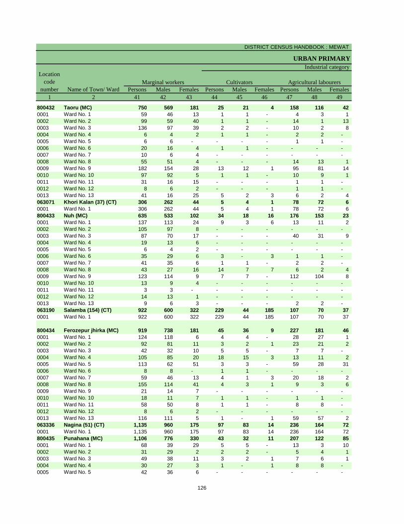
DISTRICT CENSUS HANDBOOK : MEWAT
URBAN PRIMARY
Persons Males Females Persons Males Females Persons Males Females1 2 41 42 43 44 45 46 47 48 49
800432 Taoru (MC) 750 569 181 25 21 4 158 116 42 0001 Ward No. 1 59 46 13 1 1 - 4 3 1 0002 Ward No. 2 99 59 40 1 1 - 14 1 13 0003 Ward No. 3 136 97 39 2 2 - 10 2 8 0004 Ward No. 4 6 4 2 1 1 - 2 2 - 0005 Ward No. 5 6 6 - - - - 1 1 - 0006 Ward No. 6 20 16 4 1 1 - - - - 0007 Ward No. 7 10 6 4 - - - - - - 0008 Ward No. 8 55 51 4 - - - 14 13 1 0009 Ward No. 9 182 154 28 13 12 1 95 81 14 0010 Ward No. 10 97 92 5 1 1 - 10 9 1 0011 Ward No. 11 31 16 15 - - - 1 1 - 0012 Ward No. 12 8 6 2 - - - 1 1 - 0013 Ward No. 13 41 16 25 5 2 3 6 2 4 063071 Khori Kalan (37) (CT) 306 262 44 5 4 1 78 72 6 0001 Ward No. 1 306 262 44 5 4 1 78 72 6 800433 Nuh (MC) 635 533 102 34 18 16 176 153 23 0001 Ward No. 1 137 113 24 9 3 6 13 11 2 0002 Ward No. 2 105 97 8 - - - - - - 0003 Ward No. 3 87 70 17 - - - 40 31 9 0004 Ward No. 4 19 13 6 - - - - - - 0005 Ward No. 5 6 4 2 - - - - - - 0006 Ward No. 6 35 29 6 3 - 3 1 1 - 0007 Ward No. 7 41 35 6 1 1 - 2 2 - 0008 Ward No. 8 43 27 16 14 7 7 6 2 4 0009 Ward No. 9 123 114 9 7 7 - 112 104 8 0010 Ward No. 10 13 9 4 - - - - - - 0011 Ward No. 11 3 3 - - - - - - - 0012 Ward No. 12 14 13 1 - - - - - - 0013 Ward No. 13 9 6 3 - - - 2 2 - 063190 Salamba (154) (CT) 922 600 322 229 44 185 107 70 37 0001 Ward No. 1 922 600 322 229 44 185 107 70 37
800434 Ferozepur jhirka (MC) 919 738 181 45 36 9 227 181 46 0001 Ward No. 1 124 118 6 4 4 - 28 27 1 0002 Ward No. 2 92 81 11 3 2 1 23 21 2 0003 Ward No. 3 42 32 10 5 5 - 7 7 - 0004 Ward No. 4 105 85 20 18 15 3 13 11 2 0005 Ward No. 5 113 62 51 3 3 - 59 28 31 0006 Ward No. 6 8 8 - 1 1 - - - - 0007 Ward No. 7 59 46 13 4 1 3 20 18 2 0008 Ward No. 8 155 114 41 4 3 1 9 3 6 0009 Ward No. 9 21 14 7 - - - - - - 0010 Ward No. 10 18 11 7 1 1 - 1 1 - 0011 Ward No. 11 58 50 8 1 1 - 8 8 - 0012 Ward No. 12 8 6 2 - - - - - - 0013 Ward No. 13 116 111 5 1 - 1 59 57 2 063336 Nagina (51) (CT) 1,135 960 175 97 83 14 236 164 72 0001 Ward No. 1 1,135 960 175 97 83 14 236 164 72 800435 Punahana (MC) 1,106 776 330 43 32 11 207 122 85 0001 Ward No. 1 68 39 29 5 5 - 13 3 10 0002 Ward No. 2 31 29 2 2 2 - 5 4 1 0003 Ward No. 3 49 38 11 3 2 1 7 6 1 0004 Ward No. 4 30 27 3 1 - 1 8 8 - 0005 Ward No. 5 42 36 6 - - - - - -
Location code
number Name of Town/ WardMarginal workers Cultivators Agricultural labourers
Industrial category
126
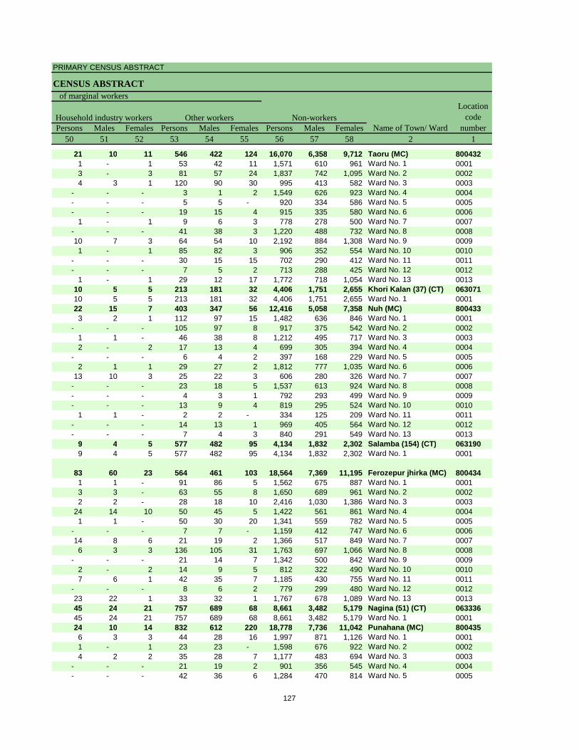
PRIMARY CENSUS ABSTRACT
CENSUS ABSTRACT
Persons Males Females Persons Males Females Persons Males Females50 51 52 53 54 55 56 57 58 2 1
21 10 11 546 422 124 16,070 6,358 9,712 Taoru (MC) 8004321 - 1 53 42 11 1,571 610 961 Ward No. 1 00013 - 3 81 57 24 1,837 742 1,095 Ward No. 2 00024 3 1 120 90 30 995 413 582 Ward No. 3 0003
- - - 3 1 2 1,549 626 923 Ward No. 4 0004- - - 5 5 - 920 334 586 Ward No. 5 0005- - - 19 15 4 915 335 580 Ward No. 6 0006
1 - 1 9 6 3 778 278 500 Ward No. 7 0007- - - 41 38 3 1,220 488 732 Ward No. 8 000810 7 3 64 54 10 2,192 884 1,308 Ward No. 9 00091 - 1 85 82 3 906 352 554 Ward No. 10 0010
- - - 30 15 15 702 290 412 Ward No. 11 0011- - - 7 5 2 713 288 425 Ward No. 12 0012
1 - 1 29 12 17 1,772 718 1,054 Ward No. 13 001310 5 5 213 181 32 4,406 1,751 2,655 Khori Kalan (37) (CT) 06307110 5 5 213 181 32 4,406 1,751 2,655 Ward No. 1 000122 15 7 403 347 56 12,416 5,058 7,358 Nuh (MC) 8004333 2 1 112 97 15 1,482 636 846 Ward No. 1 0001
- - - 105 97 8 917 375 542 Ward No. 2 00021 1 - 46 38 8 1,212 495 717 Ward No. 3 00032 - 2 17 13 4 699 305 394 Ward No. 4 0004
- - - 6 4 2 397 168 229 Ward No. 5 00052 1 1 29 27 2 1,812 777 1,035 Ward No. 6 0006
13 10 3 25 22 3 606 280 326 Ward No. 7 0007- - - 23 18 5 1,537 613 924 Ward No. 8 0008- - - 4 3 1 792 293 499 Ward No. 9 0009- - - 13 9 4 819 295 524 Ward No. 10 0010
1 1 - 2 2 - 334 125 209 Ward No. 11 0011- - - 14 13 1 969 405 564 Ward No. 12 0012- - - 7 4 3 840 291 549 Ward No. 13 0013
9 4 5 577 482 95 4,134 1,832 2,302 Salamba (154) (CT) 0631909 4 5 577 482 95 4,134 1,832 2,302 Ward No. 1 0001
83 60 23 564 461 103 18,564 7,369 11,195 Ferozepur jhirka (MC) 8004341 1 - 91 86 5 1,562 675 887 Ward No. 1 00013 3 - 63 55 8 1,650 689 961 Ward No. 2 00022 2 - 28 18 10 2,416 1,030 1,386 Ward No. 3 0003
24 14 10 50 45 5 1,422 561 861 Ward No. 4 00041 1 - 50 30 20 1,341 559 782 Ward No. 5 0005
- - - 7 7 - 1,159 412 747 Ward No. 6 000614 8 6 21 19 2 1,366 517 849 Ward No. 7 00076 3 3 136 105 31 1,763 697 1,066 Ward No. 8 0008
- - - 21 14 7 1,342 500 842 Ward No. 9 00092 - 2 14 9 5 812 322 490 Ward No. 10 00107 6 1 42 35 7 1,185 430 755 Ward No. 11 0011
- - - 8 6 2 779 299 480 Ward No. 12 001223 22 1 33 32 1 1,767 678 1,089 Ward No. 13 001345 24 21 757 689 68 8,661 3,482 5,179 Nagina (51) (CT) 06333645 24 21 757 689 68 8,661 3,482 5,179 Ward No. 1 000124 10 14 832 612 220 18,778 7,736 11,042 Punahana (MC) 8004356 3 3 44 28 16 1,997 871 1,126 Ward No. 1 00011 - 1 23 23 - 1,598 676 922 Ward No. 2 00024 2 2 35 28 7 1,177 483 694 Ward No. 3 0003
- - - 21 19 2 901 356 545 Ward No. 4 0004- - - 42 36 6 1,284 470 814 Ward No. 5 0005
Non-workersLocation
code number
Household industry workersName of Town/ Ward
Other workers
of marginal workers
127
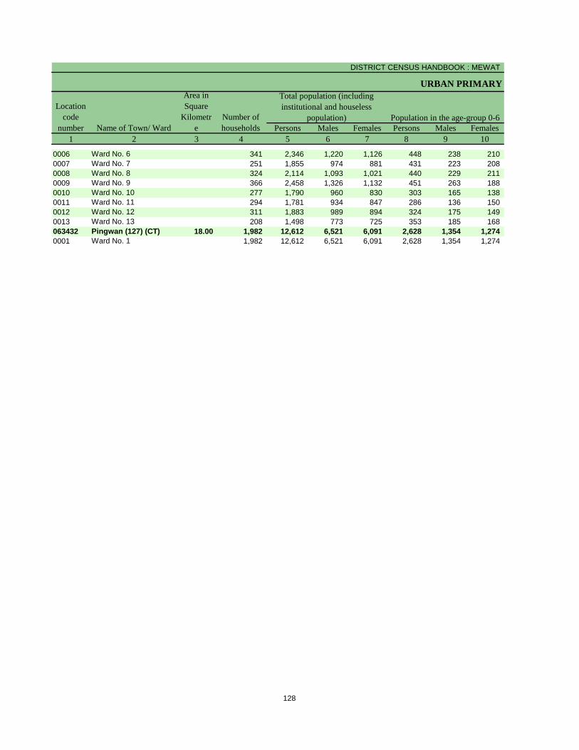
DISTRICT CENSUS HANDBOOK : MEWAT
URBAN PRIMARY
Persons Males Females Persons Males Females1 2 3 4 5 6 7 8 9 10
Population in the age-group 0-6Name of Town/ Ward
Location code
number
Total population (including institutional and houseless
population)
Area in Square
Kilometre
Number of households
0006 Ward No. 6 341 2,346 1,220 1,126 448 238 210 0007 Ward No. 7 251 1,855 974 881 431 223 208 0008 Ward No. 8 324 2,114 1,093 1,021 440 229 211 0009 Ward No. 9 366 2,458 1,326 1,132 451 263 188 0010 Ward No. 10 277 1,790 960 830 303 165 138 0011 Ward No. 11 294 1,781 934 847 286 136 150 0012 Ward No. 12 311 1,883 989 894 324 175 149 0013 Ward No. 13 208 1,498 773 725 353 185 168 063432 Pingwan (127) (CT) 18.00 1,982 12,612 6,521 6,091 2,628 1,354 1,274 0001 Ward No. 1 1,982 12,612 6,521 6,091 2,628 1,354 1,274
128
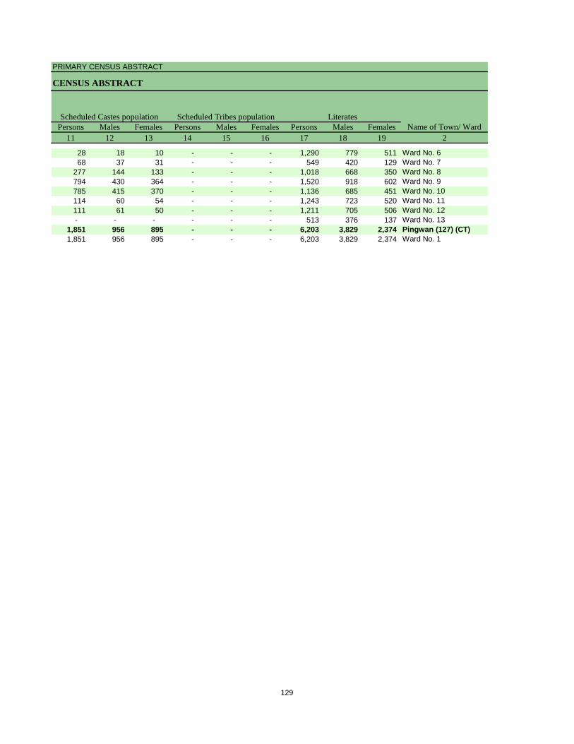
PRIMARY CENSUS ABSTRACT
CENSUS ABSTRACT
Persons Males Females Persons Males Females Persons Males Females11 12 13 14 15 16 17 18 19 2
Scheduled Castes population Scheduled Tribes population LiteratesName of Town/ Ward
28 18 10 - - - 1,290 779 511 Ward No. 668 37 31 - - - 549 420 129 Ward No. 7
277 144 133 - - - 1,018 668 350 Ward No. 8794 430 364 - - - 1,520 918 602 Ward No. 9785 415 370 - - - 1,136 685 451 Ward No. 10114 60 54 - - - 1,243 723 520 Ward No. 11111 61 50 - - - 1,211 705 506 Ward No. 12- - - - - - 513 376 137 Ward No. 13
1,851 956 895 - - - 6,203 3,829 2,374 Pingwan (127) (CT)1,851 956 895 - - - 6,203 3,829 2,374 Ward No. 1
129
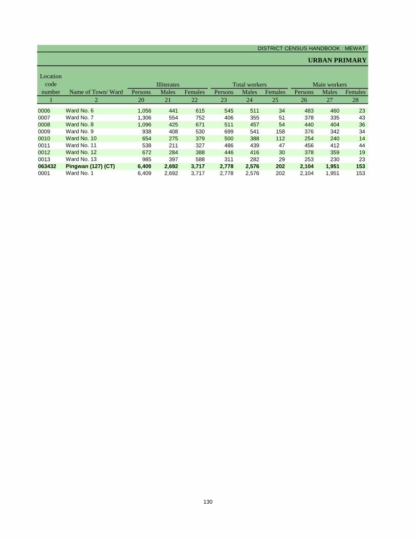
DISTRICT CENSUS HANDBOOK : MEWAT
URBAN PRIMARY
Persons Males Females Persons Males Females Persons Males Females1 2 20 21 22 23 24 25 26 27 28
Illiterates Total workers Main workersName of Town/ Ward
Location code
number
0006 Ward No. 6 1,056 441 615 545 511 34 483 460 23 0007 Ward No. 7 1,306 554 752 406 355 51 378 335 43 0008 Ward No. 8 1,096 425 671 511 457 54 440 404 36 0009 Ward No. 9 938 408 530 699 541 158 376 342 34 0010 Ward No. 10 654 275 379 500 388 112 254 240 14 0011 Ward No. 11 538 211 327 486 439 47 456 412 44 0012 Ward No. 12 672 284 388 446 416 30 378 359 19 0013 Ward No. 13 985 397 588 311 282 29 253 230 23 063432 Pingwan (127) (CT) 6,409 2,692 3,717 2,778 2,576 202 2,104 1,951 153 0001 Ward No. 1 6,409 2,692 3,717 2,778 2,576 202 2,104 1,951 153
130
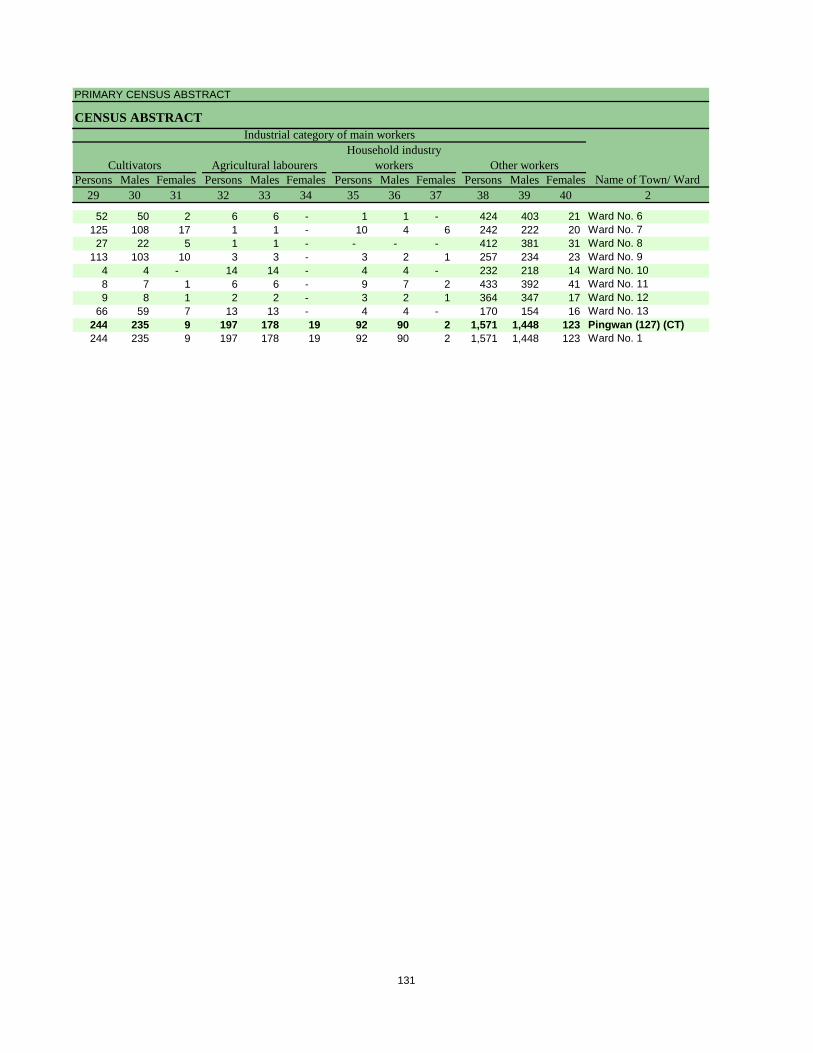
PRIMARY CENSUS ABSTRACT
CENSUS ABSTRACT
Persons Males Females Persons Males Females Persons Males Females Persons Males Females29 30 31 32 33 34 35 36 37 38 39 40 2
CultivatorsName of Town/ Ward
Household industry workersAgricultural labourers
Industrial category of main workers
Other workers
52 50 2 6 6 - 1 1 - 424 403 21 Ward No. 6125 108 17 1 1 - 10 4 6 242 222 20 Ward No. 727 22 5 1 1 - - - - 412 381 31 Ward No. 8
113 103 10 3 3 - 3 2 1 257 234 23 Ward No. 94 4 - 14 14 - 4 4 - 232 218 14 Ward No. 108 7 1 6 6 - 9 7 2 433 392 41 Ward No. 119 8 1 2 2 - 3 2 1 364 347 17 Ward No. 12
66 59 7 13 13 - 4 4 - 170 154 16 Ward No. 13244 235 9 197 178 19 92 90 2 1,571 1,448 123 Pingwan (127) (CT)244 235 9 197 178 19 92 90 2 1,571 1,448 123 Ward No. 1
131
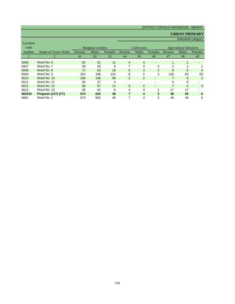
DISTRICT CENSUS HANDBOOK : MEWAT
URBAN PRIMARY
Persons Males Females Persons Males Females Persons Males Females1 2 41 42 43 44 45 46 47 48 49
Location code
number Name of Town/ WardMarginal workers Cultivators Agricultural labourers
Industrial category
0006 Ward No. 6 62 51 11 4 4 - 1 1 - 0007 Ward No. 7 28 20 8 7 4 3 2 1 1 0008 Ward No. 8 71 53 18 5 3 2 9 5 4 0009 Ward No. 9 323 199 124 8 5 3 126 63 63 0010 Ward No. 10 246 148 98 2 2 - 7 5 2 0011 Ward No. 11 30 27 3 - - - 5 5 - 0012 Ward No. 12 68 57 11 2 2 - 7 4 3 0013 Ward No. 13 58 52 6 4 3 1 17 17 - 063432 Pingwan (127) (CT) 674 625 49 7 4 3 46 40 6 0001 Ward No. 1 674 625 49 7 4 3 46 40 6
132
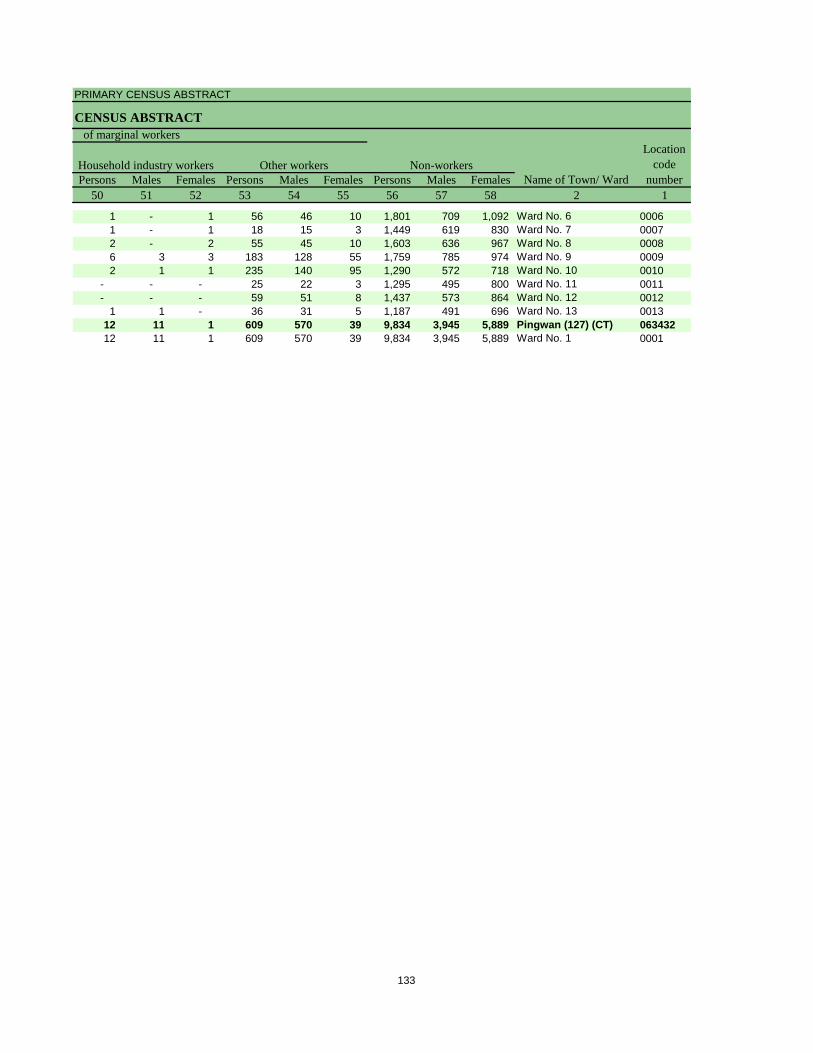
PRIMARY CENSUS ABSTRACT
CENSUS ABSTRACT
Persons Males Females Persons Males Females Persons Males Females50 51 52 53 54 55 56 57 58 2 1
Non-workersLocation
code number
Household industry workersName of Town/ Ward
Other workers
of marginal workers
1 - 1 56 46 10 1,801 709 1,092 Ward No. 6 00061 - 1 18 15 3 1,449 619 830 Ward No. 7 00072 - 2 55 45 10 1,603 636 967 Ward No. 8 00086 3 3 183 128 55 1,759 785 974 Ward No. 9 00092 1 1 235 140 95 1,290 572 718 Ward No. 10 0010
- - - 25 22 3 1,295 495 800 Ward No. 11 0011- - - 59 51 8 1,437 573 864 Ward No. 12 0012
1 1 - 36 31 5 1,187 491 696 Ward No. 13 001312 11 1 609 570 39 9,834 3,945 5,889 Pingwan (127) (CT) 06343212 11 1 609 570 39 9,834 3,945 5,889 Ward No. 1 0001
133

Section – II
Tables based on Households Amenities and Assets
(Rural /Urban) at District and Sub-District level

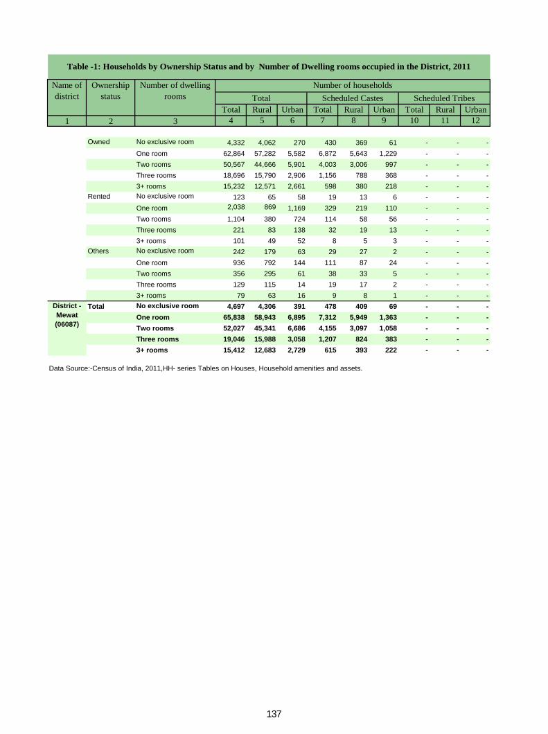
Total Rural Urban Total Rural Urban Total Rural Urban1 2 3 4 5 6 7 8 9 10 11 12
Owned No exclusive room 4,332 4,062 270 430 369 61 - - -One room 62,864 57,282 5,582 6,872 5,643 1,229 - - -Two rooms 50,567 44,666 5,901 4,003 3,006 997 - - -Three rooms 18,696 15,790 2,906 1,156 788 368 - - -3+ rooms 15,232 12,571 2,661 598 380 218 - - -
Rented No exclusive room 123 65 58 19 13 6 - - -One room 2,038 869 1,169 329 219 110 - - -Two rooms 1,104 380 724 114 58 56 - - -Three rooms 221 83 138 32 19 13 - - -3+ rooms 101 49 52 8 5 3 - - -
Others No exclusive room 242 179 63 29 27 2 - - -One room 936 792 144 111 87 24 - - -Two rooms 356 295 61 38 33 5 - - -Three rooms 129 115 14 19 17 2 - - -3+ rooms 79 63 16 9 8 1 - - -
Total No exclusive room 4,697 4,306 391 478 409 69 - - -One room 65,838 58,943 6,895 7,312 5,949 1,363 - - -Two rooms 52,027 45,341 6,686 4,155 3,097 1,058 - - -Three rooms 19,046 15,988 3,058 1,207 824 383 - - -3+ rooms 15,412 12,683 2,729 615 393 222 - - -
Data Source:-Census of India, 2011,HH- series Tables on Houses, Household amenities and assets.
District - Mewat (06087)
Table -1: Households by Ownership Status and by Number of Dwelling rooms occupied in the District, 2011
Name of district
Number of householdsTotal Scheduled Castes Scheduled Tribes
Ownership status
Number of dwelling rooms
137
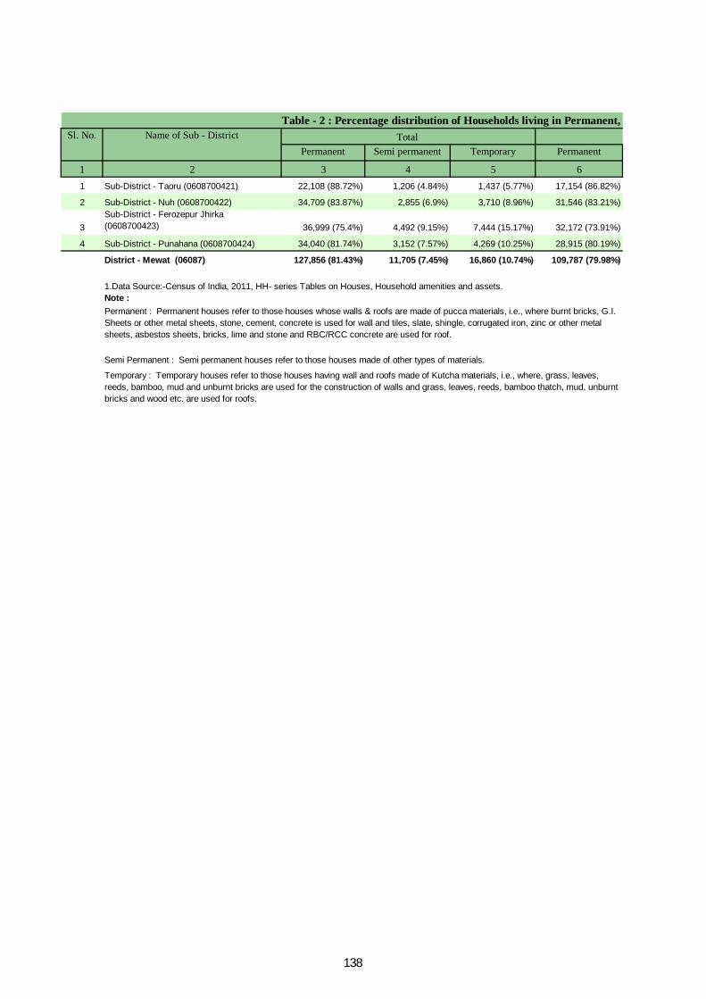
Permanent Semi permanent Temporary Permanent
1 2 3 4 5 61 Sub-District - Taoru (0608700421) 22,108 (88.72%) 1,206 (4.84%) 1,437 (5.77%) 17,154 (86.82%)
2 Sub-District - Nuh (0608700422) 34,709 (83.87%) 2,855 (6.9%) 3,710 (8.96%) 31,546 (83.21%)
3Sub-District - Ferozepur Jhirka (0608700423) 36,999 (75.4%) 4,492 (9.15%) 7,444 (15.17%) 32,172 (73.91%)
4 Sub-District - Punahana (0608700424) 34,040 (81.74%) 3,152 (7.57%) 4,269 (10.25%) 28,915 (80.19%)
District - Mewat (06087) 127,856 (81.43%) 11,705 (7.45%) 16,860 (10.74%) 109,787 (79.98%)
Note :
Sl. No. Name of Sub - District Total
1.Data Source:-Census of India, 2011, HH- series Tables on Houses, Household amenities and assets.
Permanent : Permanent houses refer to those houses whose walls & roofs are made of pucca materials, i.e., where burnt bricks, G.I. Sheets or other metal sheets, stone, cement, concrete is used for wall and tiles, slate, shingle, corrugated iron, zinc or other metal sheets, asbestos sheets, bricks, lime and stone and RBC/RCC concrete are used for roof.
Semi Permanent : Semi permanent houses refer to those houses made of other types of materials.
Temporary : Temporary houses refer to those houses having wall and roofs made of Kutcha materials, i.e., where, grass, leaves, reeds, bamboo, mud and unburnt bricks are used for the construction of walls and grass, leaves, reeds, bamboo thatch, mud, unburnt bricks and wood etc. are used for roofs.
Table - 2 : Percentage distribution of Households living in Permanent,
138
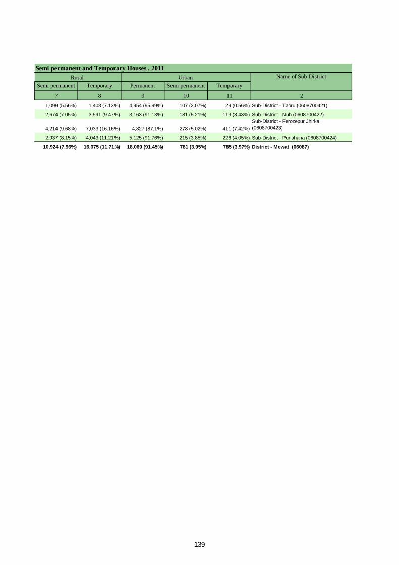
Semi permanent Temporary Permanent Semi permanent Temporary
7 8 9 10 11 21,099 (5.56%) 1,408 (7.13%) 4,954 (95.99%) 107 (2.07%) 29 (0.56%) Sub-District - Taoru (0608700421)
2,674 (7.05%) 3,591 (9.47%) 3,163 (91.13%) 181 (5.21%) 119 (3.43%) Sub-District - Nuh (0608700422)
4,214 (9.68%) 7,033 (16.16%) 4,827 (87.1%) 278 (5.02%) 411 (7.42%)Sub-District - Ferozepur Jhirka (0608700423)
2,937 (8.15%) 4,043 (11.21%) 5,125 (91.76%) 215 (3.85%) 226 (4.05%) Sub-District - Punahana (0608700424)
10,924 (7.96%) 16,075 (11.71%) 18,069 (91.45%) 781 (3.95%) 785 (3.97%) District - Mewat (06087)
Semi permanent and Temporary Houses , 2011Urban Name of Sub-DistrictRural
139

Tap water from treated source
Tap water from untreated source
Covered well Un-covered well
1 2 3 4 5 6 7 81 Total 24,920 8,786 (35.26%) 5,118 (20.54%) 81 (0.33%) 153 (0.61%)
Rural 19,759 5,136 (25.99%) 4,682 (23.7%) 76 (0.38%) 137 (0.69%)Urban 5,161 3,650 (70.72%) 436 (8.45%) 5 (0.1%) 16 (0.31%)
2 Total 41,384 11,804 (28.52%) 7,449 (18%) 1,423 (3.44%) 5,465 (13.21%)Rural 37,913 9,701 (25.59%) 6,833 (18.02%) 1,267 (3.34%) 5,414 (14.28%)Urban 3,471 2,103 (60.59%) 616 (17.75%) 156 (4.49%) 51 (1.47%)
3 Total 49,073 9,884 (20.14%) 4,845 (9.87%) 1,257 (2.56%) 9,917 (20.21%)Rural 43,531 6,369 (14.63%) 4,048 (9.3%) 1,220 (2.8%) 9,857 (22.64%)Urban 5,542 3,515 (63.42%) 797 (14.38%) 37 (0.67%) 60 (1.08%)
4 Total 41,643 5,238 (12.58%) 4,892 (11.75%) 746 (1.79%) 7,360 (17.67%)Rural 36,058 3,405 (9.44%) 3,968 (11%) 719 (1.99%) 7,316 (20.29%)Urban 5,585 1,833 (32.82%) 924 (16.54%) 27 (0.48%) 44 (0.79%)Total 157,020 35,712 (22.74%) 22,304 (14.2%) 3,507 (2.23%) 22,895 (14.58%)Rural 137,261 24,611 (17.93%) 19,531 (14.23%) 3,282 (2.39%) 22,724 (16.56%)Urban 19,759 11,101 (56.18%) 2,773 (14.03%) 225 (1.14%) 171 (0.87%)
Data Source:-Census of India, 2011,HH- series Tables on Houses, Household amenities and assets.
Table -3 : Number and Percentage of Households Sl. No.
Name of Sub-District
Total/ Rural/ Urban
Total Number of households
Number and percentage of Household
Note: Percentage is given in brackets after the number of households.
Sub-District - Taoru
(0608700421)
Sub-District - Nuh
(0608700422)
Sub-District - Ferozepur Jhirka
(0608700423)
Sub-District - Punahana
(0608700424)
District - Mewat (06087)
140
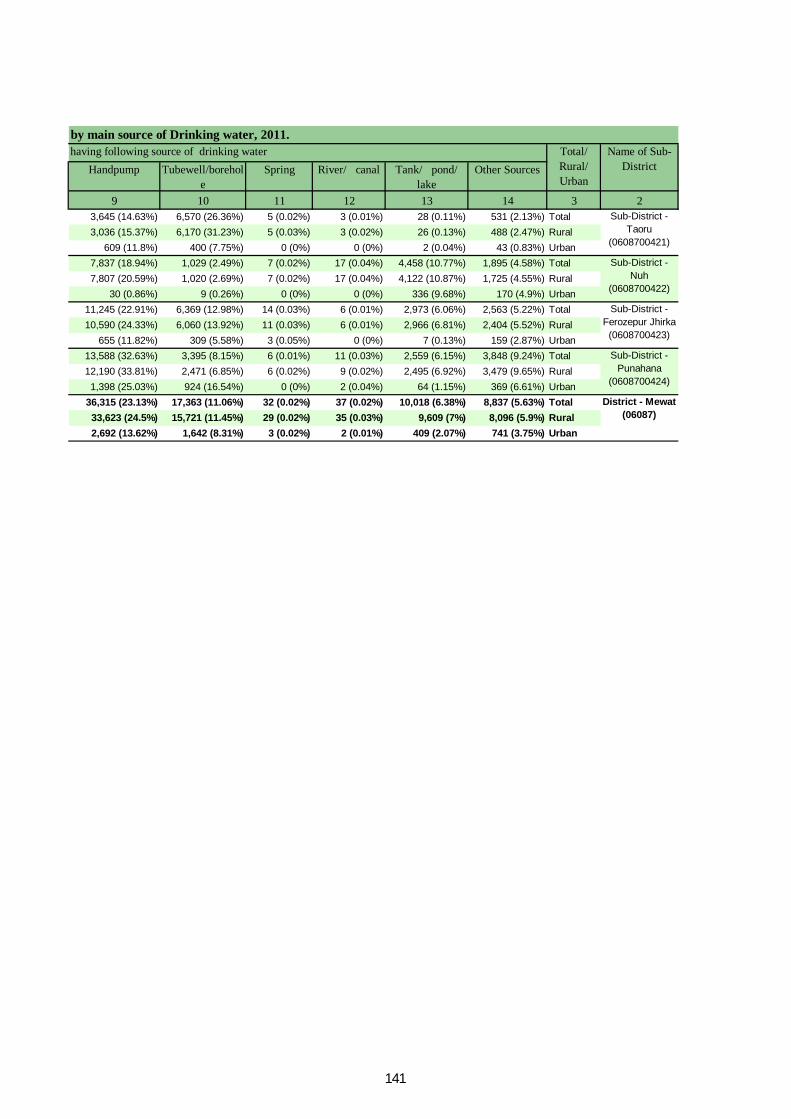
Handpump Tubewell/borehole
Spring River/ canal Tank/ pond/ lake
Other Sources
9 10 11 12 13 14 3 23,645 (14.63%) 6,570 (26.36%) 5 (0.02%) 3 (0.01%) 28 (0.11%) 531 (2.13%) Total3,036 (15.37%) 6,170 (31.23%) 5 (0.03%) 3 (0.02%) 26 (0.13%) 488 (2.47%) Rural
609 (11.8%) 400 (7.75%) 0 (0%) 0 (0%) 2 (0.04%) 43 (0.83%) Urban7,837 (18.94%) 1,029 (2.49%) 7 (0.02%) 17 (0.04%) 4,458 (10.77%) 1,895 (4.58%) Total7,807 (20.59%) 1,020 (2.69%) 7 (0.02%) 17 (0.04%) 4,122 (10.87%) 1,725 (4.55%) Rural
30 (0.86%) 9 (0.26%) 0 (0%) 0 (0%) 336 (9.68%) 170 (4.9%) Urban11,245 (22.91%) 6,369 (12.98%) 14 (0.03%) 6 (0.01%) 2,973 (6.06%) 2,563 (5.22%) Total10,590 (24.33%) 6,060 (13.92%) 11 (0.03%) 6 (0.01%) 2,966 (6.81%) 2,404 (5.52%) Rural
655 (11.82%) 309 (5.58%) 3 (0.05%) 0 (0%) 7 (0.13%) 159 (2.87%) Urban13,588 (32.63%) 3,395 (8.15%) 6 (0.01%) 11 (0.03%) 2,559 (6.15%) 3,848 (9.24%) Total12,190 (33.81%) 2,471 (6.85%) 6 (0.02%) 9 (0.02%) 2,495 (6.92%) 3,479 (9.65%) Rural1,398 (25.03%) 924 (16.54%) 0 (0%) 2 (0.04%) 64 (1.15%) 369 (6.61%) Urban
36,315 (23.13%) 17,363 (11.06%) 32 (0.02%) 37 (0.02%) 10,018 (6.38%) 8,837 (5.63%) Total33,623 (24.5%) 15,721 (11.45%) 29 (0.02%) 35 (0.03%) 9,609 (7%) 8,096 (5.9%) Rural2,692 (13.62%) 1,642 (8.31%) 3 (0.02%) 2 (0.01%) 409 (2.07%) 741 (3.75%) Urban
by main source of Drinking water, 2011.Name of Sub-
Districthaving following source of drinking water Total/
Rural/ Urban
Sub-District - Taoru
(0608700421)
Sub-District - Nuh
(0608700422)
Sub-District - Ferozepur Jhirka
(0608700423)
Sub-District - Punahana
(0608700424)
District - Mewat (06087)
141
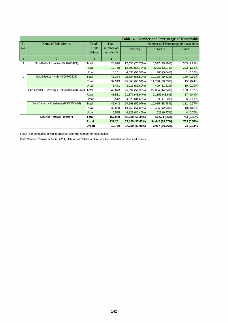
Electricity Kerosene Solar
1 2 3 4 5 6 71 Total 24,920 17,630 (70.75%) 6,327 (25.39%) 303 (1.22%)
Rural 19,759 12,800 (64.78%) 6,067 (30.7%) 302 (1.53%)Urban 5,161 4,830 (93.59%) 260 (5.04%) 1 (0.02%)
2 Total 41,384 28,384 (68.59%) 12,128 (29.31%) 160 (0.39%)Rural 37,913 25,368 (66.91%) 11,728 (30.93%) 150 (0.4%)Urban 3,471 3,016 (86.89%) 400 (11.52%) 10 (0.29%)
3 Total 49,073 25,697 (52.36%) 22,054 (44.94%) 180 (0.37%)Rural 43,531 21,172 (48.64%) 21,156 (48.6%) 174 (0.4%)Urban 5,542 4,525 (81.65%) 898 (16.2%) 6 (0.11%)
4 Total 41,643 24,598 (59.07%) 16,025 (38.48%) 111 (0.27%)Rural 36,058 19,769 (54.83%) 15,496 (42.98%) 107 (0.3%)Urban 5,585 4,829 (86.46%) 529 (9.47%) 4 (0.07%)Total 157,020 96,309 (61.34%) 56,534 (36%) 754 (0.48%)Rural 137,261 79,109 (57.63%) 54,447 (39.67%) 733 (0.53%)Urban 19,759 17,200 (87.05%) 2,087 (10.56%) 21 (0.11%)
Data Source:-Census of India, 2011, HH- series Tables on Houses, Household amenities and assets.
Table- 4 : Number and Percentage of Households Sl. No.
Name of Sub-District Total/ Rural/ Urban
Total number of households
Number and Percentage of households
Note: Percentage is given in brackets after the number of households.
Sub-District - Taoru (0608700421)
Sub-District - Nuh (0608700422)
Sub-District - Ferozepur Jhirka (0608700423)
Sub-District - Punahana (0608700424)
District - Mewat (06087)
142
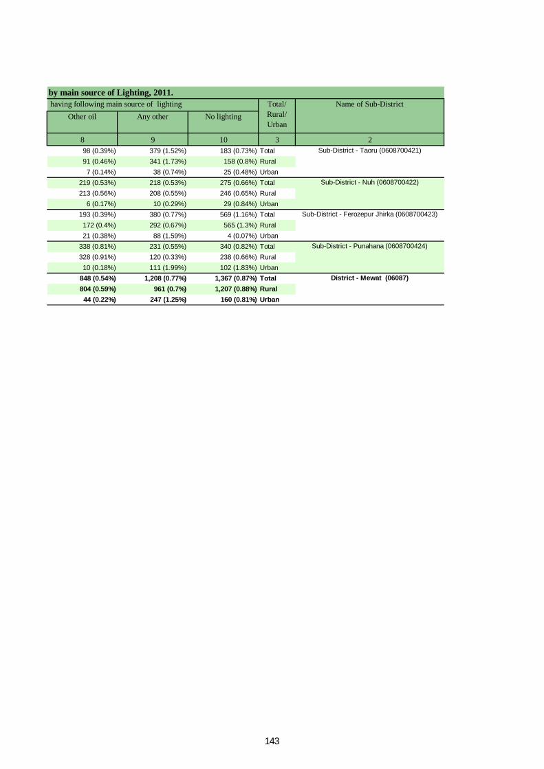
Other oil Any other No lighting
8 9 10 3 298 (0.39%) 379 (1.52%) 183 (0.73%) Total91 (0.46%) 341 (1.73%) 158 (0.8%) Rural7 (0.14%) 38 (0.74%) 25 (0.48%) Urban
219 (0.53%) 218 (0.53%) 275 (0.66%) Total213 (0.56%) 208 (0.55%) 246 (0.65%) Rural
6 (0.17%) 10 (0.29%) 29 (0.84%) Urban193 (0.39%) 380 (0.77%) 569 (1.16%) Total172 (0.4%) 292 (0.67%) 565 (1.3%) Rural21 (0.38%) 88 (1.59%) 4 (0.07%) Urban
338 (0.81%) 231 (0.55%) 340 (0.82%) Total328 (0.91%) 120 (0.33%) 238 (0.66%) Rural10 (0.18%) 111 (1.99%) 102 (1.83%) Urban
848 (0.54%) 1,208 (0.77%) 1,367 (0.87%) Total804 (0.59%) 961 (0.7%) 1,207 (0.88%) Rural44 (0.22%) 247 (1.25%) 160 (0.81%) Urban
Name of Sub-Districtby main source of Lighting, 2011. having following main source of lighting Total/
Rural/ Urban
Sub-District - Taoru (0608700421)
Sub-District - Nuh (0608700422)
Sub-District - Ferozepur Jhirka (0608700423)
Sub-District - Punahana (0608700424)
District - Mewat (06087)
143
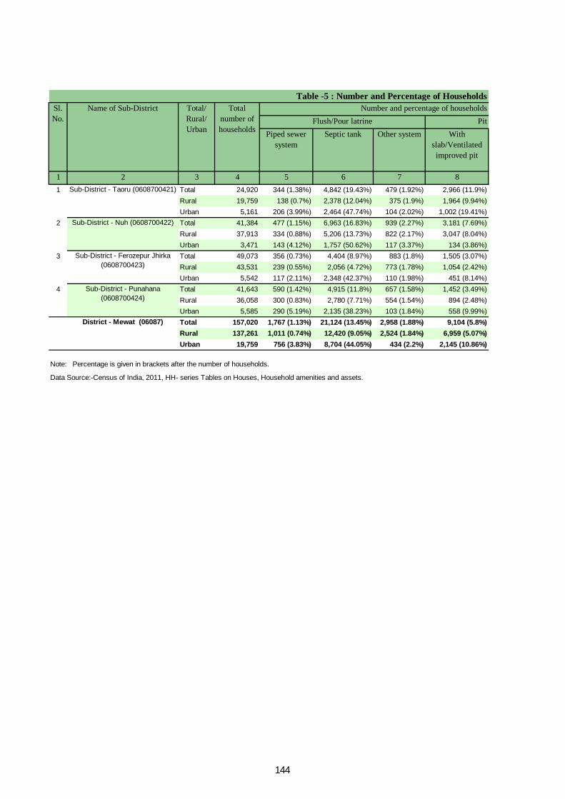
Pit Piped sewer
systemSeptic tank Other system With
slab/Ventilated improved pit
1 2 3 4 5 6 7 81 Total 24,920 344 (1.38%) 4,842 (19.43%) 479 (1.92%) 2,966 (11.9%)
Rural 19,759 138 (0.7%) 2,378 (12.04%) 375 (1.9%) 1,964 (9.94%)Urban 5,161 206 (3.99%) 2,464 (47.74%) 104 (2.02%) 1,002 (19.41%)
2 Total 41,384 477 (1.15%) 6,963 (16.83%) 939 (2.27%) 3,181 (7.69%)Rural 37,913 334 (0.88%) 5,206 (13.73%) 822 (2.17%) 3,047 (8.04%)Urban 3,471 143 (4.12%) 1,757 (50.62%) 117 (3.37%) 134 (3.86%)
3 Total 49,073 356 (0.73%) 4,404 (8.97%) 883 (1.8%) 1,505 (3.07%)Rural 43,531 239 (0.55%) 2,056 (4.72%) 773 (1.78%) 1,054 (2.42%)Urban 5,542 117 (2.11%) 2,348 (42.37%) 110 (1.98%) 451 (8.14%)
4 Total 41,643 590 (1.42%) 4,915 (11.8%) 657 (1.58%) 1,452 (3.49%)Rural 36,058 300 (0.83%) 2,780 (7.71%) 554 (1.54%) 894 (2.48%)Urban 5,585 290 (5.19%) 2,135 (38.23%) 103 (1.84%) 558 (9.99%)Total 157,020 1,767 (1.13%) 21,124 (13.45%) 2,958 (1.88%) 9,104 (5.8%)Rural 137,261 1,011 (0.74%) 12,420 (9.05%) 2,524 (1.84%) 6,959 (5.07%)Urban 19,759 756 (3.83%) 8,704 (44.05%) 434 (2.2%) 2,145 (10.86%)
Data Source:-Census of India, 2011, HH- series Tables on Houses, Household amenities and assets.
Note: Percentage is given in brackets after the number of households.
Sub-District - Taoru (0608700421)
Sub-District - Nuh (0608700422)
Sub-District - Ferozepur Jhirka (0608700423)
Sub-District - Punahana (0608700424)
District - Mewat (06087)
Table -5 : Number and Percentage of Households Sl. No.
Name of Sub-District Total/ Rural/ Urban
Total number of households
Flush/Pour latrine Number and percentage of households
144
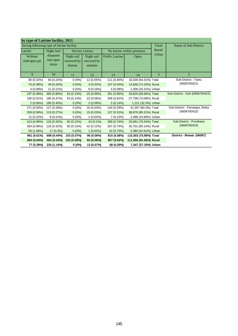
LatrineWithout
slab/open pitNight soil
removed by human
Night soil serviced by
animals
Public Latrine Open
9 10 11 12 13 14 3 280 (0.32%) 60 (0.24%) 0 (0%) 12 (0.05%) 111 (0.45%) 16,026 (64.31%) Total76 (0.38%) 49 (0.25%) 0 (0%) 4 (0.02%) 107 (0.54%) 14,668 (74.23%) Rural4 (0.08%) 11 (0.21%) 0 (0%) 8 (0.16%) 4 (0.08%) 1,358 (26.31%) Urban
197 (0.48%) 369 (0.89%) 53 (0.13%) 25 (0.06%) 351 (0.85%) 28,829 (69.66%) Total195 (0.51%) 180 (0.47%) 53 (0.14%) 22 (0.06%) 346 (0.91%) 27,708 (73.08%) Rural
2 (0.06%) 189 (5.45%) 0 (0%) 3 (0.09%) 5 (0.14%) 1,121 (32.3%) Urban271 (0.55%) 127 (0.26%) 0 (0%) 16 (0.03%) 144 (0.29%) 41,367 (84.3%) Total259 (0.59%) 119 (0.27%) 0 (0%) 15 (0.03%) 137 (0.31%) 38,879 (89.31%) Rural12 (0.22%) 8 (0.14%) 0 (0%) 1 (0.02%) 7 (0.13%) 2,488 (44.89%) Urban
413 (0.99%) 133 (0.32%) 50 (0.12%) 43 (0.1%) 309 (0.74%) 33,081 (79.44%) Total354 (0.98%) 116 (0.32%) 50 (0.14%) 42 (0.12%) 267 (0.74%) 30,701 (85.14%) Rural59 (1.06%) 17 (0.3%) 0 (0%) 1 (0.02%) 42 (0.75%) 2,380 (42.61%) Urban
961 (0.61%) 689 (0.44%) 103 (0.07%) 96 (0.06%) 915 (0.58%) 119,303 (75.98%) Total884 (0.64%) 464 (0.34%) 103 (0.08%) 83 (0.06%) 857 (0.62%) 111,956 (81.56%) Rural77 (0.39%) 225 (1.14%) 0 (0%) 13 (0.07%) 58 (0.29%) 7,347 (37.18%) Urban
Sub-District - Taoru (0608700421)
Sub-District - Nuh (0608700422)
Sub-District - Ferozepur Jhirka (0608700423)
Sub-District - Punahana (0608700424)
District - Mewat (06087)
by type of Latrine facility, 2011Name of Sub-District
No latrine within premisesNight Soil disposed into open
drain
Service Latrine having following type of latrine facility Total/
Rural/ Urban
145
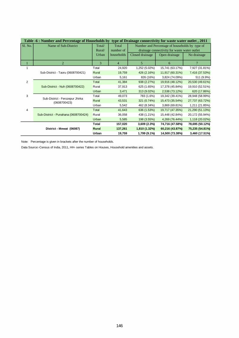
Closed drainage Open drainage No drainage
1 2 3 4 5 6 71 Total 24,920 1,252 (5.02%) 15,741 (63.17%) 7,927 (31.81%)
Rural 19,759 426 (2.16%) 11,917 (60.31%) 7,416 (37.53%)Urban 5,161 826 (16%) 3,824 (74.09%) 511 (9.9%)
2 Total 41,384 938 (2.27%) 19,916 (48.12%) 20,530 (49.61%)Rural 37,913 625 (1.65%) 17,378 (45.84%) 19,910 (52.51%)Urban 3,471 313 (9.02%) 2,538 (73.12%) 620 (17.86%)
3 Total 49,073 783 (1.6%) 19,342 (39.41%) 28,948 (58.99%)Rural 43,531 321 (0.74%) 15,473 (35.54%) 27,737 (63.72%)Urban 5,542 462 (8.34%) 3,869 (69.81%) 1,211 (21.85%)
4 Total 41,643 636 (1.53%) 19,717 (47.35%) 21,290 (51.13%)Rural 36,058 438 (1.21%) 15,448 (42.84%) 20,172 (55.94%)Urban 5,585 198 (3.55%) 4,269 (76.44%) 1,118 (20.02%)Total 157,020 3,609 (2.3%) 74,716 (47.58%) 78,695 (50.12%)Rural 137,261 1,810 (1.32%) 60,216 (43.87%) 75,235 (54.81%)Urban 19,759 1,799 (9.1%) 14,500 (73.38%) 3,460 (17.51%)
Data Source:-Census of India, 2011, HH- series Tables on Houses, Household amenities and assets.
Note: Percentage is given in brackets after the number of households.
Sub-District - Taoru (0608700421)
Sub-District - Nuh (0608700422)
Sub-District - Ferozepur Jhirka (0608700423)
Sub-District - Punahana (0608700424)
District - Mewat (06087)
Table -6 : Number and Percentage of Households by type of Drainage connectivity for waste water outlet , 2011 Sl. No. Name of Sub-District Total/
Rural/ Urban
Total number of households
Number and Percentage of households by type of drainage connectivity for waste water outlet
146
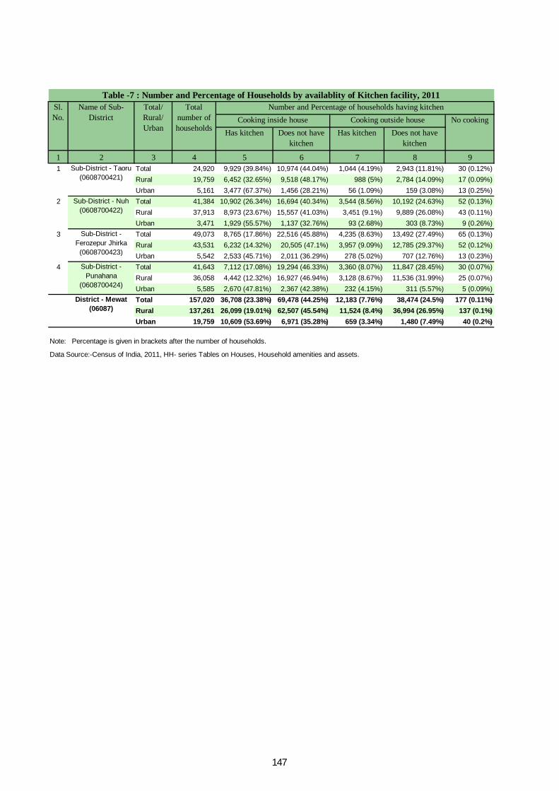
Has kitchen Does not have kitchen
Has kitchen Does not have kitchen
1 2 3 4 5 6 7 8 91 Total 24,920 9,929 (39.84%) 10,974 (44.04%) 1,044 (4.19%) 2,943 (11.81%) 30 (0.12%)
Rural 19,759 6,452 (32.65%) 9,518 (48.17%) 988 (5%) 2,784 (14.09%) 17 (0.09%)Urban 5,161 3,477 (67.37%) 1,456 (28.21%) 56 (1.09%) 159 (3.08%) 13 (0.25%)
2 Total 41,384 10,902 (26.34%) 16,694 (40.34%) 3,544 (8.56%) 10,192 (24.63%) 52 (0.13%)Rural 37,913 8,973 (23.67%) 15,557 (41.03%) 3,451 (9.1%) 9,889 (26.08%) 43 (0.11%)Urban 3,471 1,929 (55.57%) 1,137 (32.76%) 93 (2.68%) 303 (8.73%) 9 (0.26%)
3 Total 49,073 8,765 (17.86%) 22,516 (45.88%) 4,235 (8.63%) 13,492 (27.49%) 65 (0.13%)Rural 43,531 6,232 (14.32%) 20,505 (47.1%) 3,957 (9.09%) 12,785 (29.37%) 52 (0.12%)Urban 5,542 2,533 (45.71%) 2,011 (36.29%) 278 (5.02%) 707 (12.76%) 13 (0.23%)
4 Total 41,643 7,112 (17.08%) 19,294 (46.33%) 3,360 (8.07%) 11,847 (28.45%) 30 (0.07%)Rural 36,058 4,442 (12.32%) 16,927 (46.94%) 3,128 (8.67%) 11,536 (31.99%) 25 (0.07%)Urban 5,585 2,670 (47.81%) 2,367 (42.38%) 232 (4.15%) 311 (5.57%) 5 (0.09%)Total 157,020 36,708 (23.38%) 69,478 (44.25%) 12,183 (7.76%) 38,474 (24.5%) 177 (0.11%)Rural 137,261 26,099 (19.01%) 62,507 (45.54%) 11,524 (8.4%) 36,994 (26.95%) 137 (0.1%)Urban 19,759 10,609 (53.69%) 6,971 (35.28%) 659 (3.34%) 1,480 (7.49%) 40 (0.2%)
Data Source:-Census of India, 2011, HH- series Tables on Houses, Household amenities and assets.
Note: Percentage is given in brackets after the number of households.
Sub-District - Taoru (0608700421)
Sub-District - Nuh (0608700422)
Sub-District - Ferozepur Jhirka
(0608700423)
Sub-District - Punahana
(0608700424)
District - Mewat (06087)
Table -7 : Number and Percentage of Households by availablity of Kitchen facility, 2011Sl. No.
Name of Sub-District
Total/ Rural/ Urban
Total number of households
Number and Percentage of households having kitchenCooking inside house Cooking outside house No cooking
147
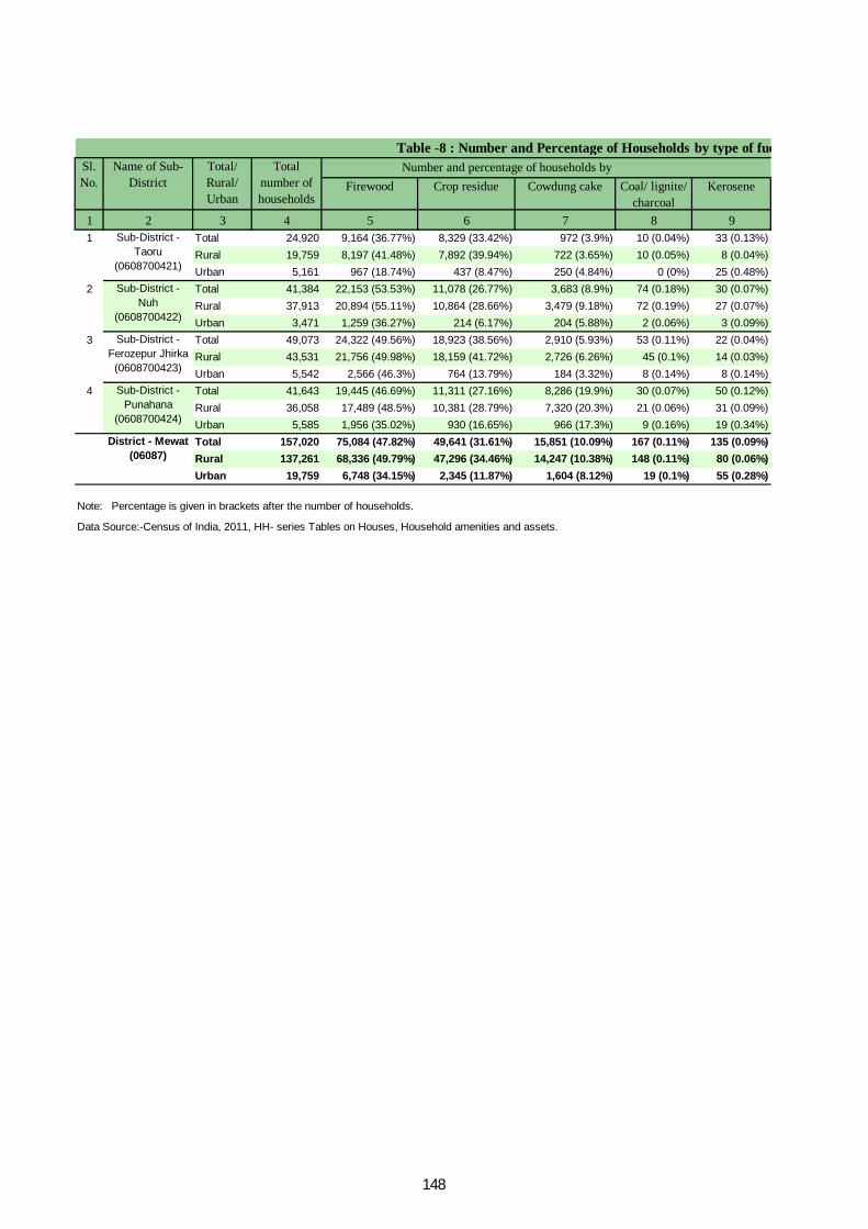
Firewood Crop residue Cowdung cake Coal/ lignite/ charcoal
Kerosene
1 2 3 4 5 6 7 8 91 Total 24,920 9,164 (36.77%) 8,329 (33.42%) 972 (3.9%) 10 (0.04%) 33 (0.13%)
Rural 19,759 8,197 (41.48%) 7,892 (39.94%) 722 (3.65%) 10 (0.05%) 8 (0.04%)Urban 5,161 967 (18.74%) 437 (8.47%) 250 (4.84%) 0 (0%) 25 (0.48%)
2 Total 41,384 22,153 (53.53%) 11,078 (26.77%) 3,683 (8.9%) 74 (0.18%) 30 (0.07%)Rural 37,913 20,894 (55.11%) 10,864 (28.66%) 3,479 (9.18%) 72 (0.19%) 27 (0.07%)Urban 3,471 1,259 (36.27%) 214 (6.17%) 204 (5.88%) 2 (0.06%) 3 (0.09%)
3 Total 49,073 24,322 (49.56%) 18,923 (38.56%) 2,910 (5.93%) 53 (0.11%) 22 (0.04%)Rural 43,531 21,756 (49.98%) 18,159 (41.72%) 2,726 (6.26%) 45 (0.1%) 14 (0.03%)Urban 5,542 2,566 (46.3%) 764 (13.79%) 184 (3.32%) 8 (0.14%) 8 (0.14%)
4 Total 41,643 19,445 (46.69%) 11,311 (27.16%) 8,286 (19.9%) 30 (0.07%) 50 (0.12%)Rural 36,058 17,489 (48.5%) 10,381 (28.79%) 7,320 (20.3%) 21 (0.06%) 31 (0.09%)Urban 5,585 1,956 (35.02%) 930 (16.65%) 966 (17.3%) 9 (0.16%) 19 (0.34%)Total 157,020 75,084 (47.82%) 49,641 (31.61%) 15,851 (10.09%) 167 (0.11%) 135 (0.09%)Rural 137,261 68,336 (49.79%) 47,296 (34.46%) 14,247 (10.38%) 148 (0.11%) 80 (0.06%)Urban 19,759 6,748 (34.15%) 2,345 (11.87%) 1,604 (8.12%) 19 (0.1%) 55 (0.28%)
Data Source:-Census of India, 2011, HH- series Tables on Houses, Household amenities and assets.
by type of fuel used for Cooking, 2011 Number and percentage of households bySl.
No. Name of Sub-
DistrictTotal/ Rural/ Urban
Total number of households
Table -8 : Number and Percentage of Households
Note: Percentage is given in brackets after the number of households.
Sub-District - Taoru
(0608700421)
Sub-District - Nuh
(0608700422)
Sub-District - Ferozepur Jhirka
(0608700423)
Sub-District - Punahana
(0608700424)
District - Mewat (06087)
148
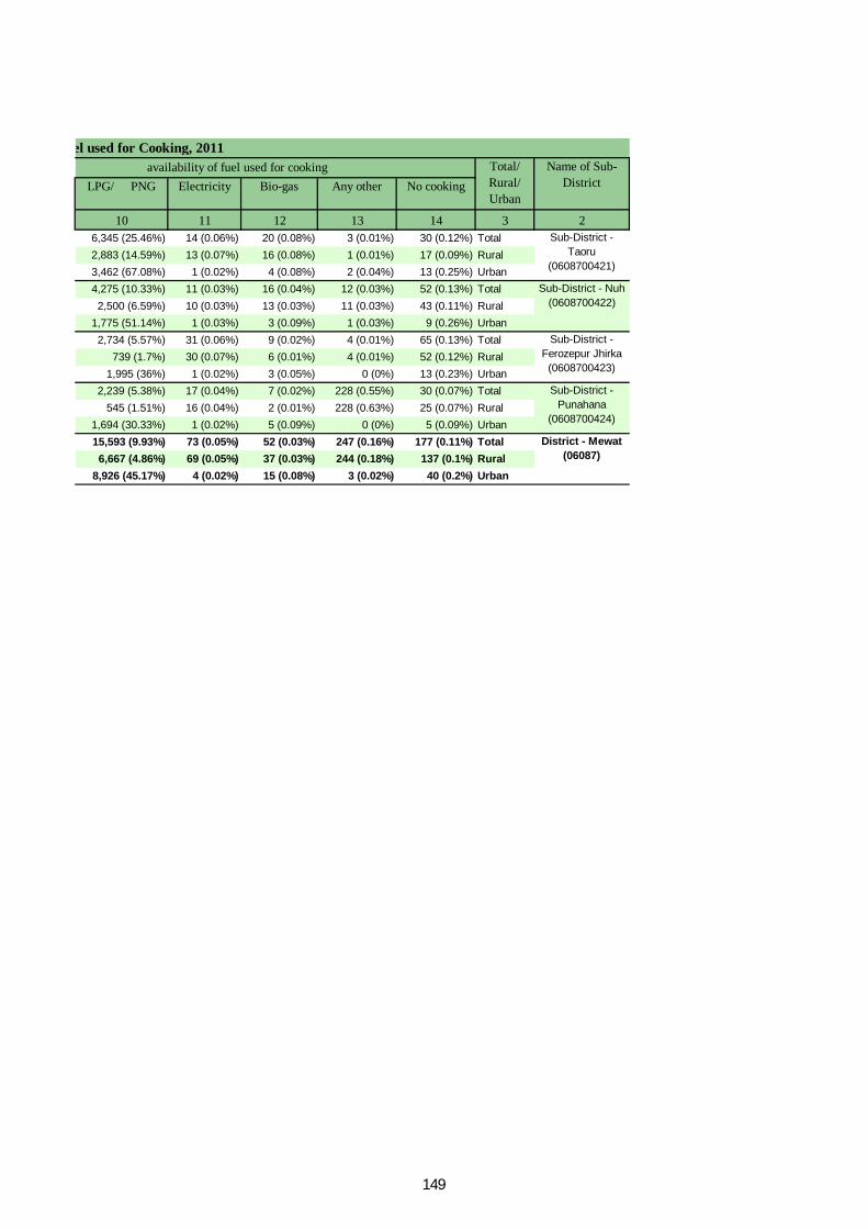
LPG/ PNG Electricity Bio-gas Any other No cooking
10 11 12 13 14 3 26,345 (25.46%) 14 (0.06%) 20 (0.08%) 3 (0.01%) 30 (0.12%) Total2,883 (14.59%) 13 (0.07%) 16 (0.08%) 1 (0.01%) 17 (0.09%) Rural3,462 (67.08%) 1 (0.02%) 4 (0.08%) 2 (0.04%) 13 (0.25%) Urban4,275 (10.33%) 11 (0.03%) 16 (0.04%) 12 (0.03%) 52 (0.13%) Total2,500 (6.59%) 10 (0.03%) 13 (0.03%) 11 (0.03%) 43 (0.11%) Rural
1,775 (51.14%) 1 (0.03%) 3 (0.09%) 1 (0.03%) 9 (0.26%) Urban2,734 (5.57%) 31 (0.06%) 9 (0.02%) 4 (0.01%) 65 (0.13%) Total
739 (1.7%) 30 (0.07%) 6 (0.01%) 4 (0.01%) 52 (0.12%) Rural1,995 (36%) 1 (0.02%) 3 (0.05%) 0 (0%) 13 (0.23%) Urban
2,239 (5.38%) 17 (0.04%) 7 (0.02%) 228 (0.55%) 30 (0.07%) Total545 (1.51%) 16 (0.04%) 2 (0.01%) 228 (0.63%) 25 (0.07%) Rural
1,694 (30.33%) 1 (0.02%) 5 (0.09%) 0 (0%) 5 (0.09%) Urban15,593 (9.93%) 73 (0.05%) 52 (0.03%) 247 (0.16%) 177 (0.11%) Total6,667 (4.86%) 69 (0.05%) 37 (0.03%) 244 (0.18%) 137 (0.1%) Rural
8,926 (45.17%) 4 (0.02%) 15 (0.08%) 3 (0.02%) 40 (0.2%) Urban
by type of fuel used for Cooking, 2011 availability of fuel used for cooking Name of Sub-
DistrictTotal/ Rural/ Urban
Sub-District - Taoru
(0608700421)
Sub-District - Nuh (0608700422)
Sub-District - Ferozepur Jhirka
(0608700423)
Sub-District - Punahana
(0608700424)
District - Mewat (06087)
149
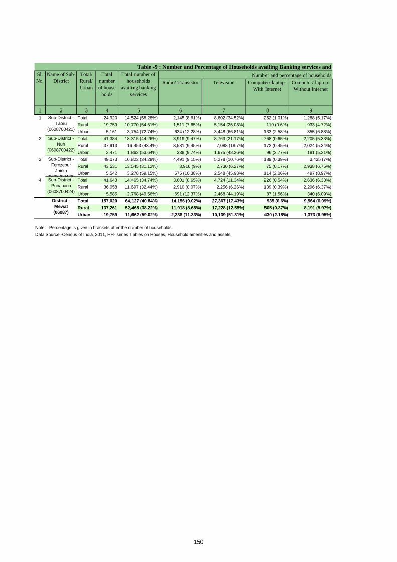
Radio/ Transistor Television Computer/ laptop- With Internet
Computer/ laptop- Without Internet
1 2 3 4 5 6 7 8 91 Total 24,920 14,524 (58.28%) 2,145 (8.61%) 8,602 (34.52%) 252 (1.01%) 1,288 (5.17%)
Rural 19,759 10,770 (54.51%) 1,511 (7.65%) 5,154 (26.08%) 119 (0.6%) 933 (4.72%)Urban 5,161 3,754 (72.74%) 634 (12.28%) 3,448 (66.81%) 133 (2.58%) 355 (6.88%)
2 Total 41,384 18,315 (44.26%) 3,919 (9.47%) 8,763 (21.17%) 268 (0.65%) 2,205 (5.33%)Rural 37,913 16,453 (43.4%) 3,581 (9.45%) 7,088 (18.7%) 172 (0.45%) 2,024 (5.34%)Urban 3,471 1,862 (53.64%) 338 (9.74%) 1,675 (48.26%) 96 (2.77%) 181 (5.21%)
3 Total 49,073 16,823 (34.28%) 4,491 (9.15%) 5,278 (10.76%) 189 (0.39%) 3,435 (7%)Rural 43,531 13,545 (31.12%) 3,916 (9%) 2,730 (6.27%) 75 (0.17%) 2,938 (6.75%)Urban 5,542 3,278 (59.15%) 575 (10.38%) 2,548 (45.98%) 114 (2.06%) 497 (8.97%)
4 Total 41,643 14,465 (34.74%) 3,601 (8.65%) 4,724 (11.34%) 226 (0.54%) 2,636 (6.33%)Rural 36,058 11,697 (32.44%) 2,910 (8.07%) 2,256 (6.26%) 139 (0.39%) 2,296 (6.37%)Urban 5,585 2,768 (49.56%) 691 (12.37%) 2,468 (44.19%) 87 (1.56%) 340 (6.09%)Total 157,020 64,127 (40.84%) 14,156 (9.02%) 27,367 (17.43%) 935 (0.6%) 9,564 (6.09%)Rural 137,261 52,465 (38.22%) 11,918 (8.68%) 17,228 (12.55%) 505 (0.37%) 8,191 (5.97%)Urban 19,759 11,662 (59.02%) 2,238 (11.33%) 10,139 (51.31%) 430 (2.18%) 1,373 (6.95%)
Data Source:-Census of India, 2011, HH- series Tables on Houses, Household amenities and assets.Note: Percentage is given in brackets after the number of households.
Sub-District - Taoru
(0608700421)
Sub-District - Nuh
(0608700422)
Sub-District - Ferozepur
Jhirka (0608700423)Sub-District -
Punahana (0608700424)
District - Mewat (06087)
Table -9 : Number and Percentage of Households availing Banking services and Total
number of house
holds
Total number of households
availing banking services
Number and percentage of households Sl. No.
Name of Sub-District
Total/ Rural/ Urban
150
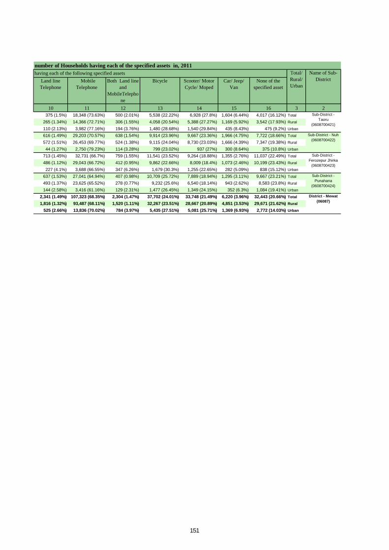
Land line Telephone
Mobile Telephone
Both Land line and
MobileTelephone
Bicycle Scooter/ Motor Cycle/ Moped
Car/ Jeep/ Van
None of the specified asset
10 11 12 13 14 15 16 3 2375 (1.5%) 18,348 (73.63%) 500 (2.01%) 5,538 (22.22%) 6,928 (27.8%) 1,604 (6.44%) 4,017 (16.12%) Total
265 (1.34%) 14,366 (72.71%) 306 (1.55%) 4,058 (20.54%) 5,388 (27.27%) 1,169 (5.92%) 3,542 (17.93%) Rural
110 (2.13%) 3,982 (77.16%) 194 (3.76%) 1,480 (28.68%) 1,540 (29.84%) 435 (8.43%) 475 (9.2%) Urban
616 (1.49%) 29,203 (70.57%) 638 (1.54%) 9,914 (23.96%) 9,667 (23.36%) 1,966 (4.75%) 7,722 (18.66%) Total
572 (1.51%) 26,453 (69.77%) 524 (1.38%) 9,115 (24.04%) 8,730 (23.03%) 1,666 (4.39%) 7,347 (19.38%) Rural
44 (1.27%) 2,750 (79.23%) 114 (3.28%) 799 (23.02%) 937 (27%) 300 (8.64%) 375 (10.8%) Urban
713 (1.45%) 32,731 (66.7%) 759 (1.55%) 11,541 (23.52%) 9,264 (18.88%) 1,355 (2.76%) 11,037 (22.49%) Total
486 (1.12%) 29,043 (66.72%) 412 (0.95%) 9,862 (22.66%) 8,009 (18.4%) 1,073 (2.46%) 10,199 (23.43%) Rural
227 (4.1%) 3,688 (66.55%) 347 (6.26%) 1,679 (30.3%) 1,255 (22.65%) 282 (5.09%) 838 (15.12%) Urban
637 (1.53%) 27,041 (64.94%) 407 (0.98%) 10,709 (25.72%) 7,889 (18.94%) 1,295 (3.11%) 9,667 (23.21%) Total
493 (1.37%) 23,625 (65.52%) 278 (0.77%) 9,232 (25.6%) 6,540 (18.14%) 943 (2.62%) 8,583 (23.8%) Rural
144 (2.58%) 3,416 (61.16%) 129 (2.31%) 1,477 (26.45%) 1,349 (24.15%) 352 (6.3%) 1,084 (19.41%) Urban
2,341 (1.49%) 107,323 (68.35%) 2,304 (1.47%) 37,702 (24.01%) 33,748 (21.49%) 6,220 (3.96%) 32,443 (20.66%) Total
1,816 (1.32%) 93,487 (68.11%) 1,520 (1.11%) 32,267 (23.51%) 28,667 (20.89%) 4,851 (3.53%) 29,671 (21.62%) Rural
525 (2.66%) 13,836 (70.02%) 784 (3.97%) 5,435 (27.51%) 5,081 (25.71%) 1,369 (6.93%) 2,772 (14.03%) Urban
Sub-District - Taoru
(0608700421)
Sub-District - Nuh (0608700422)
Sub-District - Ferozepur Jhirka
(0608700423)
Sub-District - Punahana
(0608700424)
District - Mewat (06087)
number of Households having each of the specified assets in, 2011 having each of the following specified assets Name of Sub-
DistrictTotal/ Rural/ Urban
151

ORGI - HARYANA English – (10-2011)
Directorate of Census Operations, Haryana Ministry of Home Affairs,
Government of India, Janganana Bhawan, Plot No. 2-B, Sector-19 A,
Madhya Marg, Chandigarh-160019
Email: [email protected] Website: http://www.censusindia.gov.in


