19
Biotope networking for three quarries Project by the Heidelberger Biotopschutz e. V. association for the 2014 Quarry Life Award - Final Report -
Biotope networking for three quarries
Project by the Heidelberger Biotopschutz e. V.
association for the 2014 Quarry Life Award
- Final Report -
Biotope networking for three quarries
- Final Report -
Contents
1. Initial situation1.1 Objectives
2. Implementation2.1. Conception and development activities for internal networking2.2. Conception and development activities for external networking2.3. Conception and development activities within the areas2.4. Maintenance activities2.5. Monitoring
3. Future tasks
4. Summary
5. Attachment
Biotope networking for three quarries
1. Initial situation:
The Heidelberg Rohrbach district used to feature three shell limestone quarries:
1. Leimen quarry (HeidelbergCement, left open, nature reserve)2. Rohrbach quarry (HeidelbergCement, recultivated, landscape conservation area)3. „Farmers‘ quarry“ Emmertsgrundweg (left open, § 32-c biotope)
All three former extraction sites are particularly rich in species, located close to one another, but also isolated fromeach other by barriers of groves, and hence only usable as “insular biotopes” for many species.The NGO Heidelberger Biotopschutz e. V. (HBS) has been looking after nature conservation areas and spawningwaters within the forest and in the open land districts all around the quarries for many years, and also the naturereserve at the Rohrbach quarry since the year 2000. It hence virtually suggested itself to network all the natureconservation areas, and also include the nature reserve at the Leimen quarry (a small part of which is located in theHeidelberg district) in this concept
1.1 Objectives:
HBS is aiming to network all three quarries by means of corridors that can be used by as many species as possibleto enable
a.) their migration,b.) distribution, andc.) an immigration of species
Biotope networking for three quarries
2. Implementation2.1. Conception and development activities for internal networking
Two routes were selected for the internal networking of the quarries:
1. The former extended Oberklammweg2. Former meadows and vineyards in the cadastral districts Münchberg and Mannebusch
The following development activities were required for this:
The former Oberklammweg had completely reverted to scrubland since its abandonment for use. The shrubs wereremoved, and gravel was laid out. This activity was performed by a contractor upon the initiative of the lowernature conservation authority. The result was the central part of the “grey networking corridor”
Scrubby meadows and abandoned vineyards supplemented the concept as compensation areas of the L 600 roadconstruction operations at the Heidelberg/Leimen border. After their initial treatment with a forest mulcher as partof the creation of the compensation areas by the road builders, the areas had completely reverted to scrublandagain when they were handed over to the City of Heidelberg two years ago. This had partly also be caused by thelack of an access route. HBS built an access route on its own account and in cooperation with the lower landconsolidation authority. The area can hence be reached again and kept open. The once more required initialtreatment with the forest mulcher was performed by HBS. This initial treatment measure was also supported bythe game tenants in the manual work with saws and chainsaws.
Biotope networking for three quarries
2.2. Conception and development activities for external networking
Five routes were selected for networking the quarries to the outside into the city forest and open country district:
1. A historic ravine (“Staig-Hohle”)2. The northern embankment / compensation area of the newly built highway L 6003. The former truck access route to the recultivation area at the Rohrbach quarry4. A strip of meadow at the Rohrbach quarry recultivation area in the wine-growing area5. The remainder of a meadow area with direct connection to a gorge biotope in the forest (“Hirschhorn-Grund”)6. The embankment of a former slag heap at the edge of the vineyards of Clauer winery
The following development activities were required for this:
• Trees and shrubs needed to be cut back at the Staig ravine• An access road needed to be built in the embankment of the L 600• The former truck access route still needs to be developed for networking with the Emmertsgrund valley• The strip of meadowland had already been wrested from the recultivatable wine-growing area in negotiations 10years ago and maintained by HBS ever since then. Since May 2014, this is also where the HBS panel on the subjectof edges/seams/passages as biotope structures is placed as part of the geological nature park‘s adventure hikingtrail• A strip of meadow to the “Hirschhorn-Grund“ gorge could be acquired from the Clauer winery and therebysecured• The overgrowth of the embankment of the former slag heap was cut back to the trunk in cooperation with theClauer winery
Biotope networking for three quarries
2.3. Conception and development activities within the areas
The following “stepping stone biotopes” were created in addition to this in order to upgrade the areas:
1. A dense network of small bodies of water that is constantly expanded (potential spawning sites for amphibians)2. Clearance cairns and gravel fills (reptiles, insects)3. Heaps of brushwood and stacks of wood (reptiles, amphibians, insects)4. Dry stone walls5. Free loess walls at ravines (insects, reptiles)
These structures are
a.) partly kept in a consistent condition by maintenance activities
b.) left to succession and regularly re-established again
This approach provides further contributes to the internal diversification of the areas
Biotope networking for three quarries
2.4. Maintenance activities
As opposed to development activities, maintenance activities are recurring interventions. These interventions areas a rule defined in maintenance plans. Based on the experience of HBS, the biologist Franz Auer and lower natureconservation authority have elaborated a maintenance plan for the Rohrbach quarry. Maintenance plans are alsoprovided for the compensation and networking areas.
Meadow areas are traditionally mowed in sections at scheduled intervals and the cuttings collected afterwards.This is particularly important for counteracting the eutrophication of the areas and for maintaining the ability toalways offer suitable habitats for the development cycles of butterflies. Fauna-friendly mowing methods coupledwith small-scale processing call for significant investments in terms of time and technology. HBS meets thesedemands with its own fleet of historic agricultural technology and special machines for alpine farming. In 2014,however, maintaining the areas in keeping with our wishes and objectives was nonetheless nearly impossibleowing to the weather in July and August. This problem affected the whole of Europe, with many mountain pasturesnot mowed before September or even not at all – there are years like that, but the overall concept is hardly marredby them.
The maintenance of the gravelled areas was a new issue for HBS in 2014. It goes without saying that these areasare to be kept open without resorting to herbicides, which is no simple task. The rainy summer also presented aparticular challenge here. The overgrowing of gravelled areas can only be kept in check by regular interventions.Besides hoes, heather scythes and front-loaders, the power harrow newly acquired in 2014 has proven itsusefulness for this at the two wheeled tractor, also for small and steep areas!
Biotope networking for three quarries
2.5. Monitoring
Any statement about the “value” of a nature conservation area can only be arrived at if qualified information isprovided about the species found there. Where plant species are concerned, mapping can be useful for this. Butthe quality of this mapping is highly dependent on the survey period and weather-related fluctuations. Mapping ismeanwhile only of limited use for surveying animal species because of the mobility of the individual animals. Onesolution here is a survey across a longer period of time. This surveying of species and individuals is referred to asmonitoring and particularly required for animal species with longer generation and development cycles. HBS hastherefore been surveying the spawn and larvae of amphibians or breeding pairs of birds for many years, forexample.
The surveying is done in a targeted manner, but also spontaneously and randomly:
• Surveying of bodies of water at specific dates during the spawning season of the grass frogs• Surveying in the performance of maintenance and development activities (HBS‘ largest data source)• Surveying as part of excursions or guided tours of the wine and culture adventure hiking trail
Some results of the monitoring are documented in the attachment.
Biotope networking for three quarries
3. Future tasks
The activities implemented for the QLA are only a small, but highly important time window in the overall project.The upgrading of the areas and intensification of the teamwork with the cooperation partners as part of the QLAform the basis for continuous maintenance and the implementation of further development measures. The shadingtrees and shrubs on the “eagle-owl rockface” in the Heidelberg section of the Leimen quarry are for example to beforced back in the coming months. The connection to the Emmertsgrund valley and historic quarries by way of theformer truck access route to the recultivation area is to be opened up as a “grey corridor”. Further small bodies ofwater will be created in the coming months as additional stepping stone biotopes.
The visitor guidance connected with the geological nature park’s educational „wine and culture adventure hikingtrail“ is to be enlivened and integrated in the education concept for sustainable development. The increasedbiodiversity will also continue to be documented in the monitoring in future, rendering it visible, understandableand experienceable for scientists, authorities and citizens
Biotope networking for three quarries
4. Summary
• Development activitiesFor legal reasons and from a protection of species perspective, the development activities such as removingtrees and shrubs, laying of gravel and establishment of waterbodies already had to be realized before March.Further activities will follow from October in the “grey corridor” to the north.
• Maintenance activitiesThe maintenance of the gravelled and meadow areas was primarily performed in June. Considerable rainfallsin July and August provided for strong plant growth abut also a lack of harvesting opportunities whereproduce for drying (hay) is concerned. This has made it considerably more difficult to keep some areas open.
• MonitoringThe dry June has benefited many bird and butterfly species, as well as reptiles, while the drying out of somespawning waters meant that many amphibians lost all of their larvae. Yellow-bellied-toads were able to makeuse of the wet July as a “second spring”. Additional waterbodies for spawning help to increase theirreproductive success.
• Cooperation partnersThe lower land consolidation authority could be won over to the idea of completing a “green corridor” fromthe Leimen quarry to the Rohrbach quarry by way of the L 600 compensation area (cutting across theDormenacker ravine) and by integrating an area looked after by the lower nature conservation authority. Thisinvolves the redefinition of a property and leaving it to the City of Heidelberg. The maintenance will also becarried out by HBS in this case
Biotope networking for three quarries
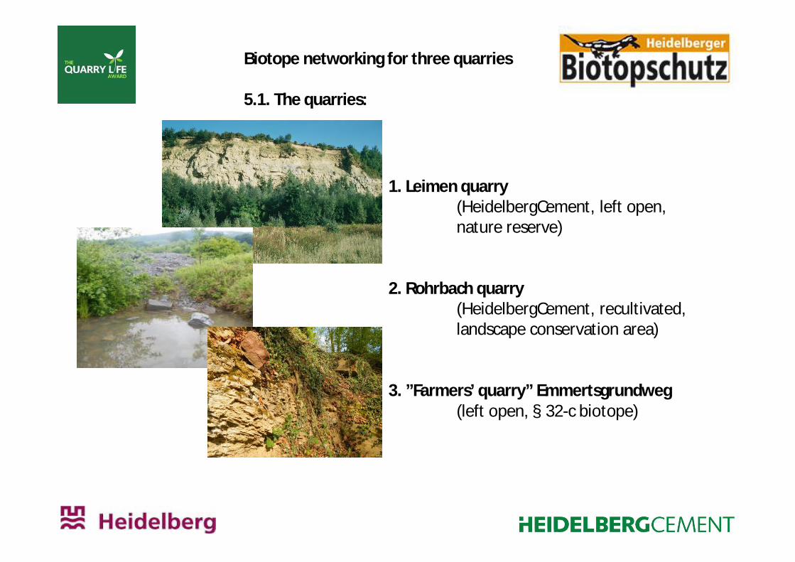
5.1. The quarries:
1. Leimen quarry(HeidelbergCement, left open,nature reserve)
2. Rohrbach quarry(HeidelbergCement, recultivated,landscape conservation area)
3. ”Farmers’ quarry” Emmertsgrundweg(left open, § 32-c biotope)
Biotope networking for three quarries
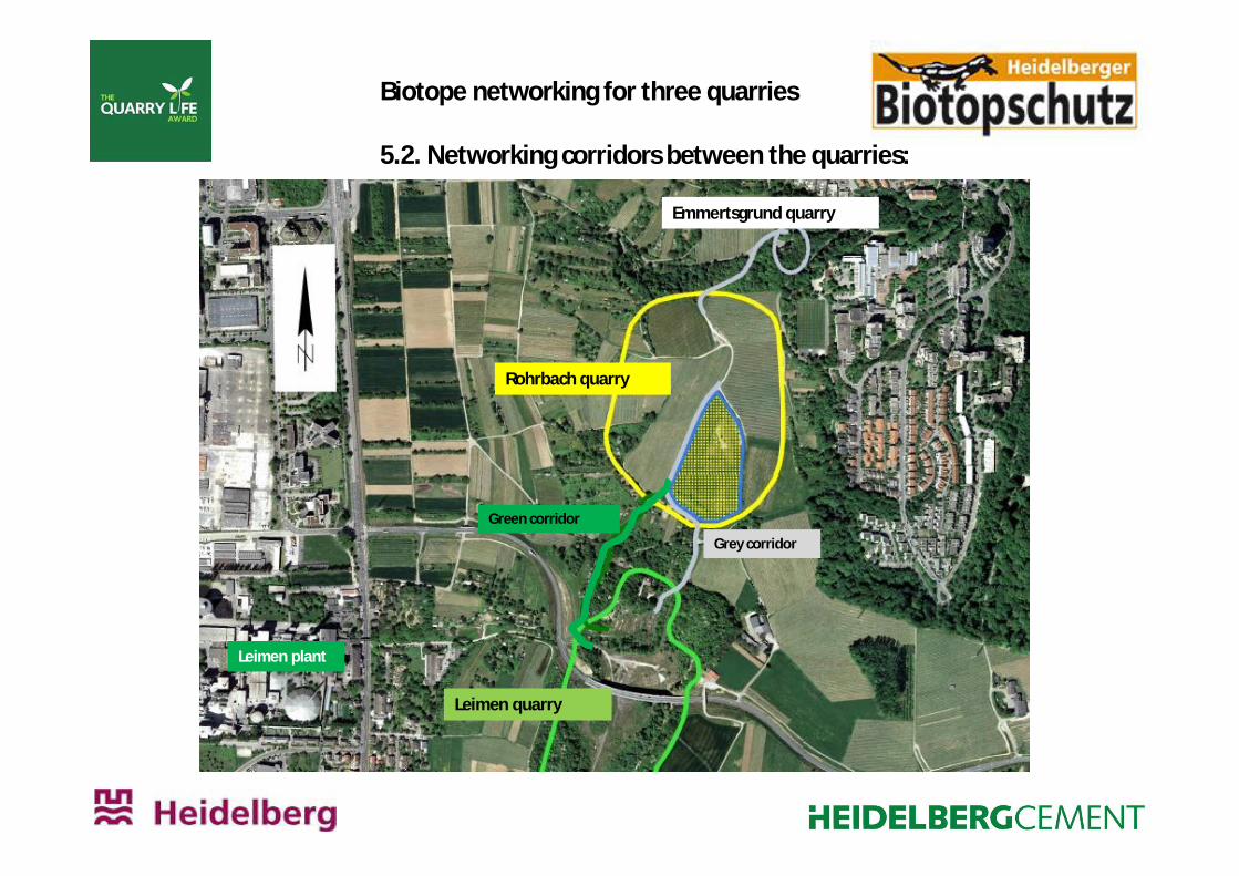
5.2. Networking corridors between the quarries:
Green corridor
Grey corridor
Rohrbach quarry
Leimen quarry
Leimen plant
Emmertsgrund quarry
1. Staig ravine 3. Connection toEmmertsgrund valley
Biotope networking for three quarries
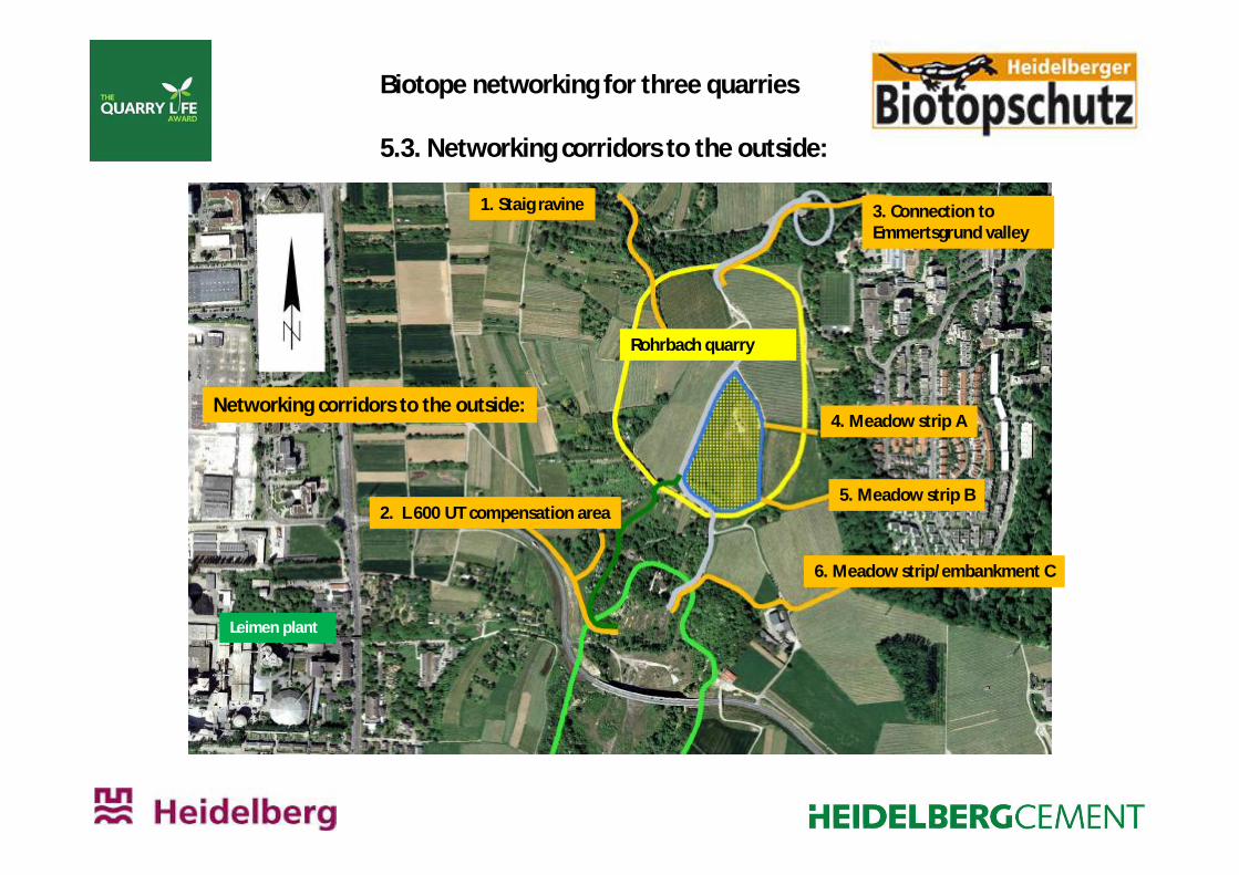
5.3. Networking corridors to the outside:
Leimen plant
Rohrbach quarry
4. Meadow strip A
5. Meadow strip B
6. Meadow strip/embankment C
Networking corridors to the outside:
2. L 600 UT compensation area
Biotope networking for three quarries
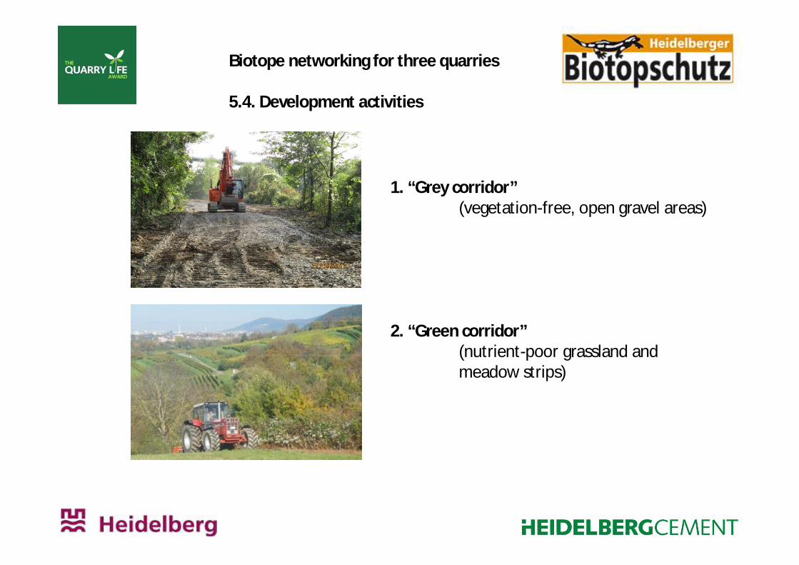
5.4. Development activities
1. “Grey corridor”(vegetation-free, open gravel areas)
2. “Green corridor”(nutrient-poor grassland andmeadow strips)
Biotope networking for three quarries
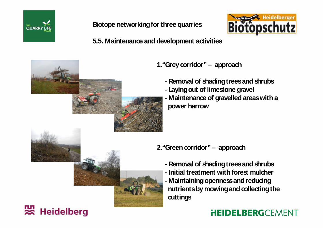
5.5. Maintenance and development activities
1.“Grey corridor” – approach
- Removal of shading trees and shrubs- Laying out of limestone gravel- Maintenance of gravelled areas with a
power harrow
2.“Green corridor” – approach
- Removal of shading trees and shrubs- Initial treatment with forest mulcher- Maintaining openness and reducing
nutrients by mowing and collecting thecuttings
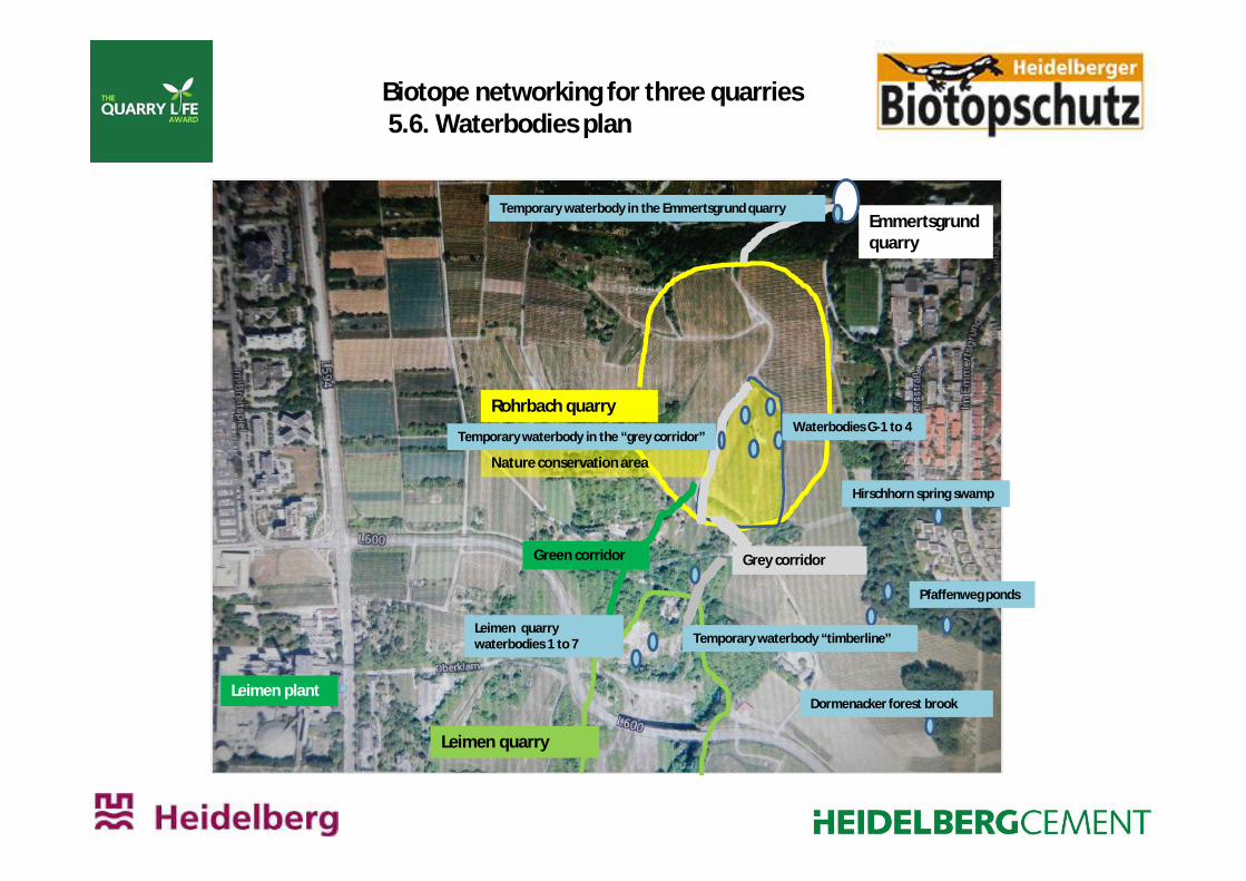
Biotope networking for three quarries5.6. Waterbodies plan
Leimen quarry
Emmertsgrundquarry
Leimen plant
Nature conservation area
Grey corridorGreen corridor
Rohrbach quarryWaterbodies G-1 to 4
Temporary waterbody in the Emmertsgrund quarry
Temporary waterbody in the “grey corridor”
Hirschhorn spring swamp
Dormenacker forest brook
Temporary waterbody “timberline”Leimen quarrywaterbodies 1 to 7
Pfaffenweg ponds
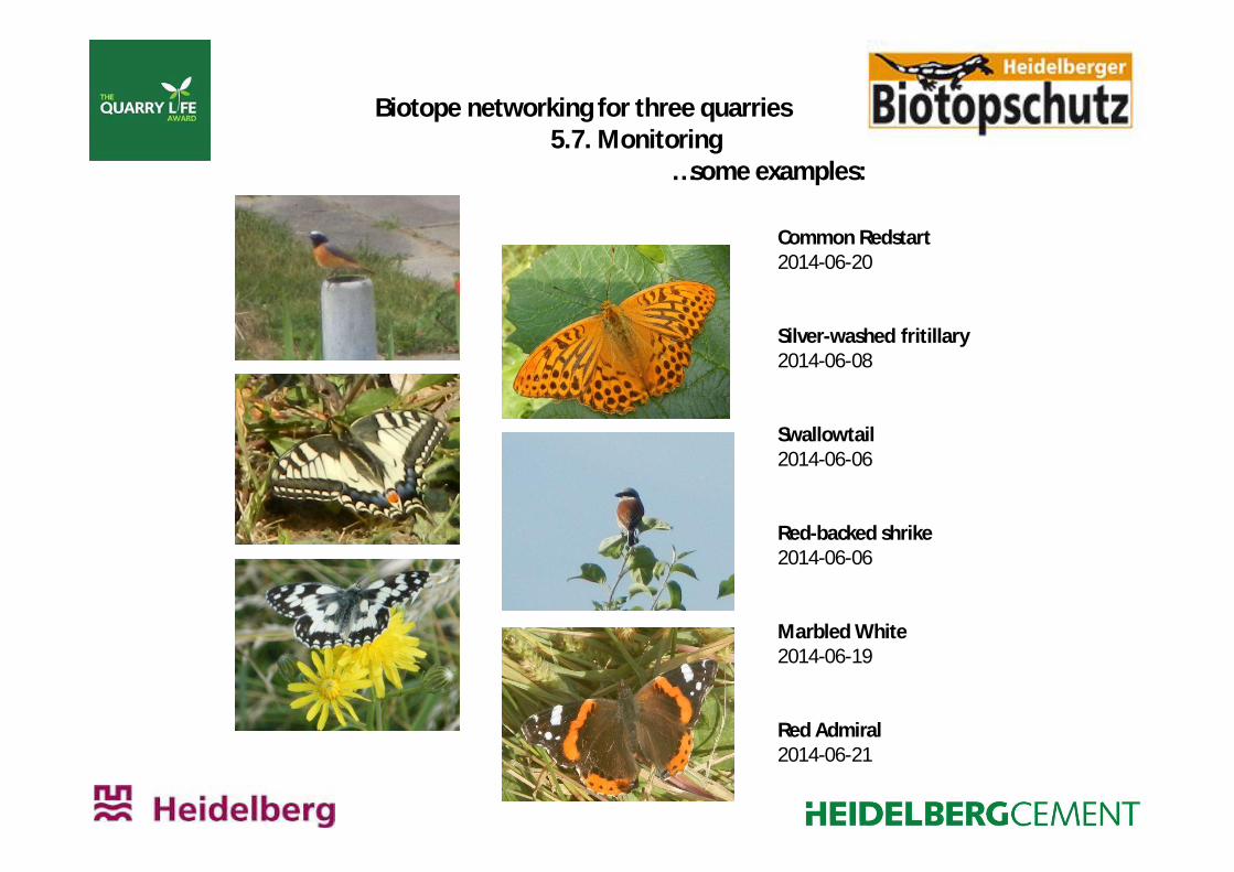
Biotope networking for three quarries5.7. Monitoring
…some examples:
Common Redstart2014-06-20
Silver-washed fritillary2014-06-08
Swallowtail2014-06-06
Red-backed shrike2014-06-06
Marbled White2014-06-19
Red Admiral2014-06-21
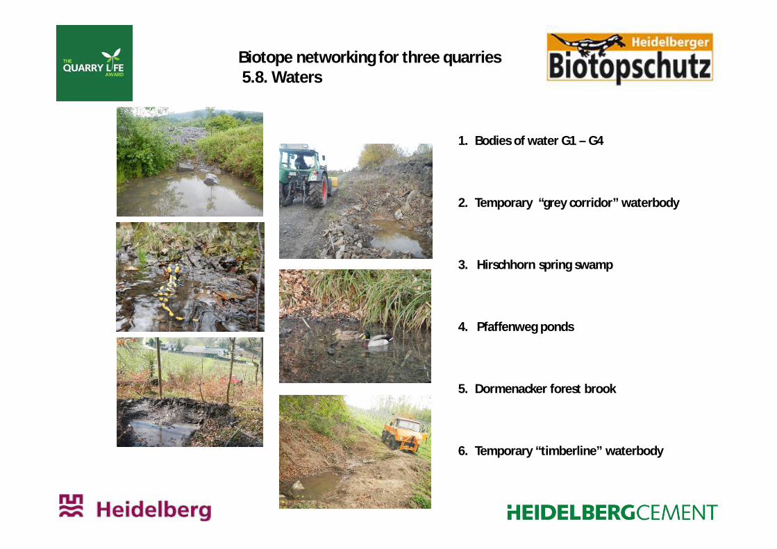
Biotope networking for three quarries5.8. Waters
1. Bodies of water G1 – G4
2. Temporary “grey corridor” waterbody
3. Hirschhorn spring swamp
4. Pfaffenweg ponds
5. Dormenacker forest brook
6. Temporary “timberline” waterbody
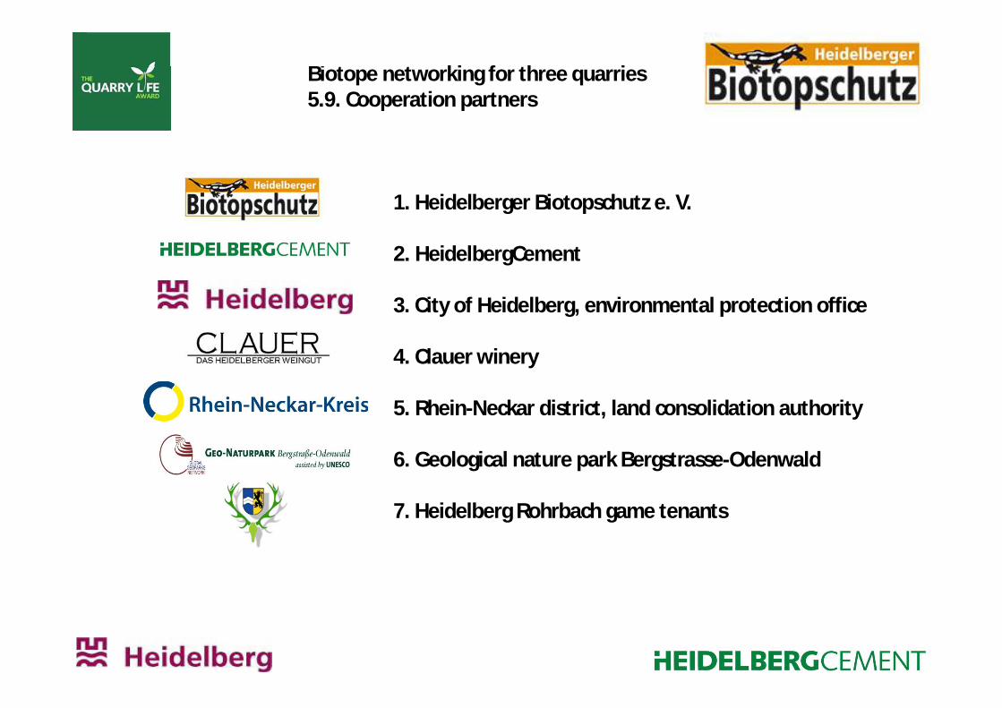
Biotope networking for three quarries5.9. Cooperation partners
1. Heidelberger Biotopschutz e. V.
2. HeidelbergCement
3. City of Heidelberg, environmental protection office
4. Clauer winery
5. Rhein-Neckar district, land consolidation authority
6. Geological nature park Bergstrasse-Odenwald
7. Heidelberg Rohrbach game tenants


