Ž . Global and Planetary Change 18 1998 175–187 Onset of aridity in southern Western Australia—a preliminary palaeomagnetic appraisal Hongbo Zheng a, ) , Karl-Heinz Wyrwoll b , Zhengxiang Li a , Chris McA Powell a a Department of Geology and Geophysics, The UniÕersity of Western Australia, Nedlands, WA 6907, Australia b Department of Geography, The UniÕersity of Western Australia, Nedlands, WA 6907, Australia Received 15 December 1996; accepted 24 June 1997 Abstract The timing of the onset of full arid conditions in southern Western Australia during the late Cenozoic remains uncertain. The playas and associated sedimentary sequences preserved as part of the Tertiary palaeodrainage networks, which are widely developed in Western Australia, provide the stratigraphic evidence necessary to resolve this issue. Lake Lefroy forms part of a chain of playas that occur in the eastern Yilgarn Craton. These lake chains are the remnants of a once external palaeodrainage system, developed in pre-Eocene times. Eocene non-marine to marginal marine sequences were deposited in the palaeodrainage as channel infills. The low relief area of the palaeodrainage featured a permanent to semi-permanent lacustrine environment during post-Eocene times, and fine-grained red–brown clastic clay up to 10 m in thickness was deposited over an extensive area. A significant hydrological transition, as inferred by the litho-sedimentary change from freshwater clay to evaporitic gypsum-dominated sedimentation, took place in the late Cenozoic. The extensive freshwater system changed to the salinerdeflation playas that characterises this landscape today. A detailed palaeomagnetic study was carried out on the lacustrine clay unit and the overlying evaporitic gypsum unit in Lake Lefroy. Results from drill core and pit wall exposures have provided the first time constraints for these sequences. Age estimates, based on extrapolation from the BrunhesrMatuyama geomagnetic boundary, suggest that the gypsum-dominated sedimentation and by inference, full arid conditions in Lake Lefroy, commenced within the Brunhes Normal Polarity Chron, probably within the last 500 Ka. This age is considerably younger than previously thought, but appears to bear some correspondence to similar claims to the age of the onset of aridity in southeast and central Australia. Evidence emerging from the inland dune field to the surrounding oceans suggests a trend of increasing aridity during the Quaternary in Australia. The onset of full aridity may well indicate that the impact of global glacial–interglacial cycles on Australian climate, especially the large scale glacial ‘dryness’ resulted from the 100 Ka astronomic variations reached beyond its threshold. q 1998 Elsevier Science B.V. All rights reserved. Keywords: Lake Lefroy; Western Australia; palaeomagnetic dating; onset of aridity 1. Introduction Widespread severe aridity characterises the physi- cal environment in Australia. Our present under- ) Corresponding author. E-mail: [email protected]standing of the timing of the onset of full arid conditions is sparse. Geomorphological evidence from central and southeastern Australia suggests that these conditions may have set in during the Quater- Ž . nary An et al., 1986; Chen and Barton, 1991 , although the first sign of aridification might have 0921-8181r98r$19.00 q 1998 Elsevier Science B.V. All rights reserved. Ž . PII S0921-8181 98 00019-8
Transcript
Ž .Global and Planetary Change 18 1998 175–187
Onset of aridity in southern Western Australia—a preliminarypalaeomagnetic appraisal
Hongbo Zheng a,), Karl-Heinz Wyrwoll b, Zhengxiang Li a, Chris McA Powell a
a Department of Geology and Geophysics, The UniÕersity of Western Australia, Nedlands, WA 6907, Australiab Department of Geography, The UniÕersity of Western Australia, Nedlands, WA 6907, Australia
Received 15 December 1996; accepted 24 June 1997
Abstract
The timing of the onset of full arid conditions in southern Western Australia during the late Cenozoic remains uncertain.The playas and associated sedimentary sequences preserved as part of the Tertiary palaeodrainage networks, which arewidely developed in Western Australia, provide the stratigraphic evidence necessary to resolve this issue. Lake Lefroy formspart of a chain of playas that occur in the eastern Yilgarn Craton. These lake chains are the remnants of a once externalpalaeodrainage system, developed in pre-Eocene times. Eocene non-marine to marginal marine sequences were deposited inthe palaeodrainage as channel infills. The low relief area of the palaeodrainage featured a permanent to semi-permanentlacustrine environment during post-Eocene times, and fine-grained red–brown clastic clay up to 10 m in thickness wasdeposited over an extensive area. A significant hydrological transition, as inferred by the litho-sedimentary change fromfreshwater clay to evaporitic gypsum-dominated sedimentation, took place in the late Cenozoic. The extensive freshwatersystem changed to the salinerdeflation playas that characterises this landscape today. A detailed palaeomagnetic study wascarried out on the lacustrine clay unit and the overlying evaporitic gypsum unit in Lake Lefroy. Results from drill core andpit wall exposures have provided the first time constraints for these sequences. Age estimates, based on extrapolation fromthe BrunhesrMatuyama geomagnetic boundary, suggest that the gypsum-dominated sedimentation and by inference, fullarid conditions in Lake Lefroy, commenced within the Brunhes Normal Polarity Chron, probably within the last 500 Ka.This age is considerably younger than previously thought, but appears to bear some correspondence to similar claims to theage of the onset of aridity in southeast and central Australia. Evidence emerging from the inland dune field to thesurrounding oceans suggests a trend of increasing aridity during the Quaternary in Australia. The onset of full aridity maywell indicate that the impact of global glacial–interglacial cycles on Australian climate, especially the large scale glacial‘dryness’ resulted from the 100 Ka astronomic variations reached beyond its threshold. q 1998 Elsevier Science B.V. Allrights reserved.
Keywords: Lake Lefroy; Western Australia; palaeomagnetic dating; onset of aridity
1. Introduction
Widespread severe aridity characterises the physi-cal environment in Australia. Our present under-
standing of the timing of the onset of full aridconditions is sparse. Geomorphological evidencefrom central and southeastern Australia suggests thatthese conditions may have set in during the Quater-
Ž .nary An et al., 1986; Chen and Barton, 1991 ,although the first sign of aridification might have
0921-8181r98r$19.00 q 1998 Elsevier Science B.V. All rights reserved.Ž .PII S0921-8181 98 00019-8
( )H. Zheng et al.rGlobal and Planetary Change 18 1998 175–187176
Žalready been present during the Miocene Bowler,.1976 .
Widespread evidence from Tertiary fauna andsedimentary sequences suggests that rainforest vege-tation dominated the Australian landscape from the
ŽPalaeocene through most of the Miocene Kemp,.1978 . Furthermore, fossil data for the Miocene sug-
gest rainforest persisted in the east and southeast ofAustralia, with open-forest in southern central Wes-
Ž .tern Australia Bint, 1981 . However, data for thistime are sparse and the geographic coverage is poor,though sufficient to indicate the beginnings of vege-tation diversification by the middle Miocene.
Ž .A recent study An et al., 1986 of the magne-tostratigraphy of Quaternary lacustrine and evapo-ritic sequences from ancient Lake Bungunnia in theMurray Basin provided time constraints on the for-mation of arid landforms in the region. Age esti-mates suggested that the onset of full aridity in this
part of Australia is of Middle Quaternary, and proba-bly falls within the last 500 Ka. Despite possibleregional differences, this time inference is reinforced
Ž .by a similar study Chen and Barton, 1991 of LakeAmadeus in central Australia, where the shift fromwet conditions to widespread aridity was palaeomag-netically dated at about 900 Ka.
The Cenozoic climatic history of southern West-ern Australia is poorly known. The timing of theonset of full aridity is uncertain. The traditional viewsuggests that aridification started in the mid-Miocene.This contention is, in part, based on the claim thatsignificant flow in the major early Tertiary
Žpalaeochannels ceased by mid-Miocene times Van.de Graaff et al., 1977 .
Ž .Parker 1988 , after having studied the paly-nomorph assemblage in the evaporitic depositsŽ .Roysalt Formation in Lake Lefroy, identified aflora genus which indicated an arid vegetation as-
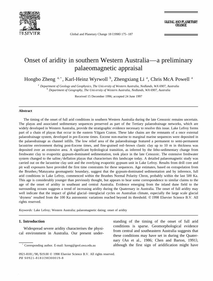
Fig. 1. Location map of study area and Tertiary palaeodrainage systems in southwestern Australia.
( )H. Zheng et al.rGlobal and Planetary Change 18 1998 175–187 177
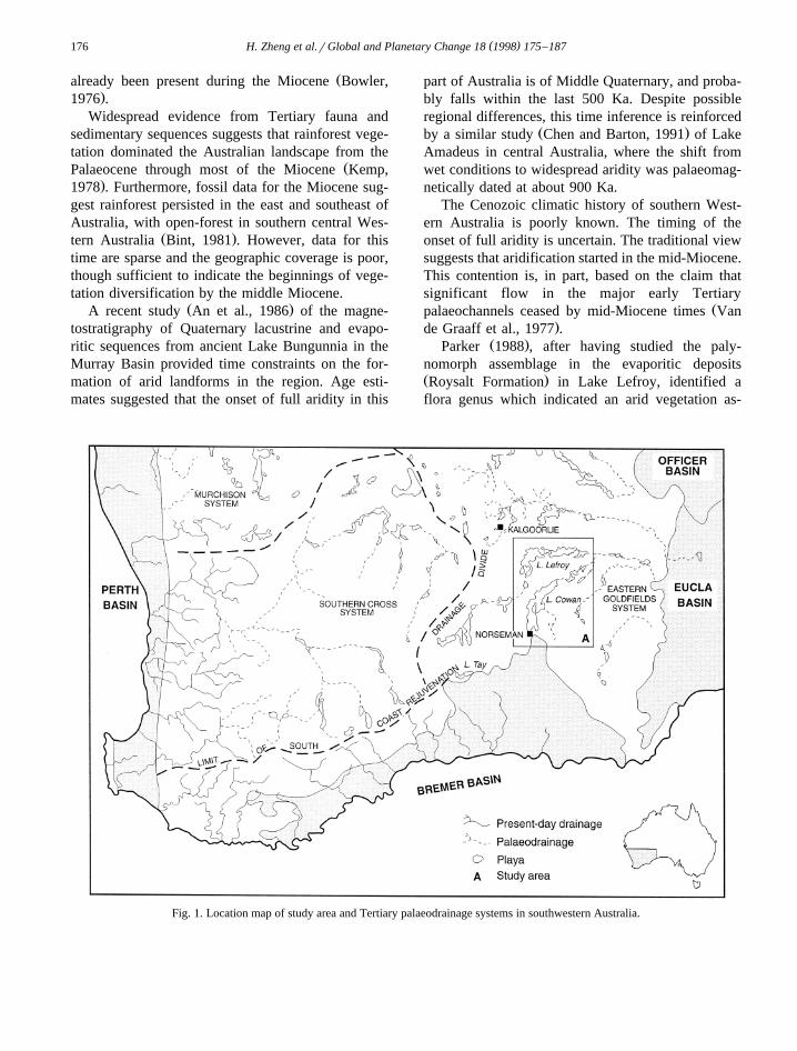
Fig. 2. Geomorphology of Lake Lefroy.
( )H. Zheng et al.rGlobal and Planetary Change 18 1998 175–187178
semblage not dissimilar to that presently surroundingLake Lefroy. It was claimed that this flora genus waslate Miocene or Early Pliocene in age, thus dating
Ž .the onset of gypsum precipitation and aridity in theŽ .Lake Lefroy basin Parker, 1988 . However Bint
Ž .1981 , who studied the pollen assemblage recoveredŽ .from the sediments of nearby Lake Tay Fig. 1 ,
suggested that regional phytogeographic differentia-tion of the flora of southern Australia was lesspronounced in the early Pliocene than generally sup-posed. In his view, a wetter regional climate with awarm temperate open-forest may have persisted wellinto the Pliocene.
Ž .Recent geomorphological work by Clarke 1993has established a general stratigraphic framework forthe Cenozoic sequences preserved in the Lake Lefroyregion. In this, the successions of extensive non-fos-siliferous, yellow, brown, and red alluvial and lacus-trine sediments and associated saline sediments andmultiple eolian units were termed as the RedmineGroup. He also recognised that a marked sedimentchange from the siliciclastic-dominated RevengeFormation to the evaporitic Roysalt Formation repre-sents a significant shift in the lake hydrology. Clarke
Ž .used the palynological inferences of Parker 1988and proposed that this change took place in latest
Ž .Miocene or Early Pliocene Clarke, 1993 .This paper presents the results of a sedimentologi-
cal and palaeomagnetic study of drill cores and openpit sections of the lacustrine sequences from Lake
Ž .Lefroy Figs. 1 and 2 . The aims are to further ourunderstanding of major Quaternary climatic and en-vironmental changes in southern Western Australia.A specific aim is to date the onset of aridity in theregion by using palaeomagnetic techniques.
2. Geological setting
2.1. Palaeodrainages in Western Australia
Tertiary palaeodrainage systems are widely devel-oped in Western Australia. They are characterised bya series of saline lakes which are either partly con-nected or are isolated along current topographic lowsŽ .Fig. 1 . The incision of these palaeochannels isthought to have been pre-Eocene, possibly even Per-mian or Jurassic. Significant flow in the palaeorivers
probably ceased before the mid-Miocene. Thepalaeodrainage patterns are preserved because of thetectonic stability of the region, and accompanying
Ž .low rates of erosion Van de Graaff et al., 1977 .The palaeochannels contain thick sequences ofCenozoic sediments. These have been extensivelydrilled and are well exposed in mine sections.
2.2. Geomorphological and morphostratigraphic fea-tures of Lake Lefroy area
Lake Lefroy is one of the playa lake chains thatoccupy the relict Tertiary palaeodrainage networks inthe Eastern Gold Field. The Lefroy palaeoriver used
Ž .to drain east towards the Eucla Basin Jones, 1990Ž .Fig. 1 . The general geomorphology of Lake Lefroy
Ž .has been outlined by Clarke 1994 . The major geo-morphological features and morphostratigraphic unitsare depicted in Fig. 2.
Along the western and northern shores of LakeLefroy Archaean and occasional Tertiary rocks out-crop as low cliffs. Erosional lake margin processesdominate this region with isolated occurrences ofdeltaic formsrdeposits where streams discharge intothe lake.
In contrast, depositional processes dominate thesouthern and eastern lake shores. Lunette dunes,often composed of bedded mud and quartz sand, arecharacteristic of these depositional processes. In someareas up to three stratigraphic generations of lunettescan be recognised, each having its own depositionalcharacteristics. Details of these lunettes includingtheir ages, palaeoenvironmental significance will beprovided elsewhere. For information on sedimento-logical features and hydrological implications of
Ž .lunette dunes, refer to Bowler 1983 .Islands are common on Lake Lefroy, those of
particular interest to this study being Alpha, Beta andŽ .Gamma Islands Fig. 2 . These islands are essentially
relict gypsum dunes composed of cross-bedded gyp-sarenite.
The present-day lake is essentially hyper-saline.Water depth seldom exceeds half a meter. Fuller lakestages are known to have occurred, associated withextreme hydrological events. Much of the lake sur-face is usually covered by a thin halite crust.
Climate in the Kambalda region is semi-arid, witha mean annual rainfall of 266 mm and annual pan
( )H. Zheng et al.rGlobal and Planetary Change 18 1998 175–187 179
evaporation of 2410 mm. The dominant wind direc-Ž .tion recorded in Kalgoorlie Fig. 1 is from the east,
but the strongest winds are from the west and north.Strong westerlies predominate in winter, with strongnortherlies in summer.
Extensive drilling and open pit mining by West-ern Mining have been carried out in the last fewyears in the lake region, and this has provided largeamounts of data on the stratigraphy of the Cenozoicsequences beneath the lake.
3. Stratigraphy of the Lefroy palaeodrainage infill
The stratigraphy of about 100 m of Cenozoicsediments preserved in the Lefroy palaeodrainage
Ž .has been described by Clarke 1993 . He divided thepalaeodrainage infills into the Eocene Eundynie
Ž .Group Cockbain, 1968 and the post-Eocene Red-mine Group. The Eundynie Group is equivalent to
Ž .the Plantagenet Group Cockbain, 1968 in the Bre-mer Basin, and lower Eucla Group in the EuclaBasin. The lower Redmine Group is a time equiva-lent to the upper Eucla Group.
The Eundynie Group in the Lefroy palaeodrainageconsists of the non-marine to marginal marine de-posits, and it rests unconformably on Archaean andProterozoic basement. Several formations within the
Žgroup Hampton Sandstone, Pidinga Formation and.Princess Royal Spongolite have also been proposed
Ž .by Clarke 1993 . The lower part of the group islargely composed of laminated red–brown to greensilts, white, grey or black carbonaceous clays andlignite. Palynomorphs recovered from the lower partof the carbonaceous sand and clay unit indicate lateMiddle to Late Eocene age. The pollen assemblage isdominated by Nothofagus species which indicatesrainforest communities.
The Redmine Group consists mainly of red–brownsilts, clays and minor sand of lacustrine and fluvial
Ž .origin Revenge Formation . The clay unit is lightlymottled and weathered in places, and contains occa-sional gypsum layers, indicating intermittent shallowwater levels and possibly complete dryness. Theupper part of the group contains bedded gypsum andis associated with eolian gypsum and sand lunette
Ž .dunes on the lake margins Roysalt Formation . Thereare two distinct types of gypsum in the unit, selenite
and gypsarenite. Selenite is used to describe gypsumdeposits in which more than 50% of the sample iscomposed of transparent crystals of gypsum with
Ž .grain size coarser than 2 mm Warren, 1982 . Gyp-sarenite is defined as gypsum which contains at least50% sand-sized gypsum grains. Although the origi-nal definition does not have a genetic connotation,the thin layers of gypsarenite found in the RoysaltFormation were almost certainly the result of defla-tion.
The lithological change from the siliciclastic Re-venge Formation to the evaporitic Roysalt Formationclearly represents a significant hydrological changein lake hydrology. As already noted the age of this
Žtransition is doubtful Parker, 1988; Clarke, 1993;.Bint, 1981 . Recently obtained palynomorphs from
the middle of the Roysalt Formation at the DeltaSouth Open Pit during this study indicate a Eucalyp-tus dominated community, but no firm claim can bemade on the age of the unit on the basis of the pollenassemblage.
4. Palaeomagnetic studies
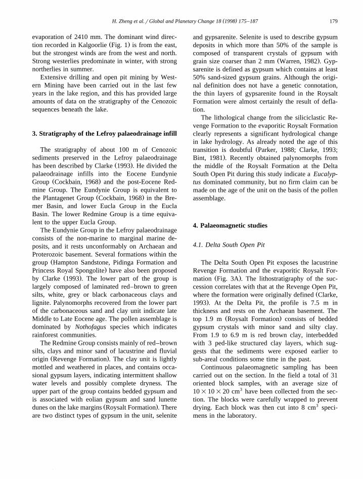
4.1. Delta South Open Pit
The Delta South Open Pit exposes the lacustrineRevenge Formation and the evaporitic Roysalt For-
Ž .mation Fig. 3A . The lithostratigraphy of the suc-cession correlates with that at the Revenge Open Pit,
Žwhere the formation were originally defined Clarke,.1993 . At the Delta Pit, the profile is 7.5 m in
thickness and rests on the Archaean basement. TheŽ .top 1.9 m Roysalt Formation consists of bedded
gypsum crystals with minor sand and silty clay.From 1.9 to 6.9 m is red brown clay, interbeddedwith 3 ped-like structured clay layers, which sug-gests that the sediments were exposed earlier tosub-areal conditions some time in the past.
Continuous palaeomagnetic sampling has beencarried out on the section. In the field a total of 31oriented block samples, with an average size of10=10=20 cm3 have been collected from the sec-tion. The blocks were carefully wrapped to preventdrying. Each block was then cut into 8 cm3 speci-mens in the laboratory.
()
H.Z
henget
al.rG
lobalandP
lanetaryC
hange18
1998175
–187
180
Ž . Ž . Ž .Fig. 3. Lithostratigraphy of: A Delta South Open Pit section; B Delta Island section; and C Eastern margin section.
( )H. Zheng et al.rGlobal and Planetary Change 18 1998 175–187 181
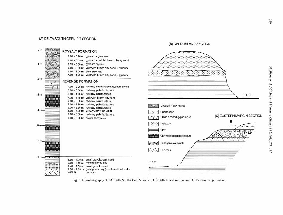
Progressive demagnetisation was used to isolatethe primary, or characteristic, remanence directions.
Ž .Alternating field AF demagnetisation up to 100 mTat an interval of 5 mT was used whenever possible.Some samples were subjected to thermal demagneti-sation up to 5508C at intervals of 508C. The natural
Ž .remanent magnetisation NRM and remanent mag-netisations of all samples were measured using acryogenic magnetometer situated, together with the
Ž .thermal demagnetiser 2G Enterprise , in a mag-netic–field-free space. The magnetostratigraphy of
the section is shown in Fig. 4, together with thestandard polarity time scale.
The BrunhesrMatuyama boundary is in the top-most part of the Revenge Formation, at a depth of2.9 m. Samples above 2.9 m are all normally magne-tised. Sampling intervals are large for this part of thesection due to a high content of gypsum crystals.
Most samples between 2.9 m to 7.28 m arereversed. The normal event between 5.8 m to 6.0 mis assigned to be the Olduvai geomagnetic sub-chron.Note the directional erratic period between 3.74 m
Fig. 4. Lithology and palaeomagnetic polarity for Delta South Open Pit. For legends, refer to Fig. 3.
( )H. Zheng et al.rGlobal and Planetary Change 18 1998 175–187182
Fig. 5. Lithology and palaeomagnetic polarity for Core LD4813.
( )H. Zheng et al.rGlobal and Planetary Change 18 1998 175–187 183
and 3.86 m. Vector analysis of the directions alongprogressive demagnetisation of these samples iso-lated two main components. The normal componentŽ .usually isolated after 50 mT probably representsthe depositional remanent magnetisation during theJaramillo normal sub-chron, and the reversed compo-nent is the overprint of the Matuyama formed duringthe process of weathering. The MatuyamarGaussboundary was found to be at 7.28 m. The boundarybetween the Roysalt Formation and the RevengeFormation is about 500 Ka if the Revenge Formationwas deposited at a constant rate.
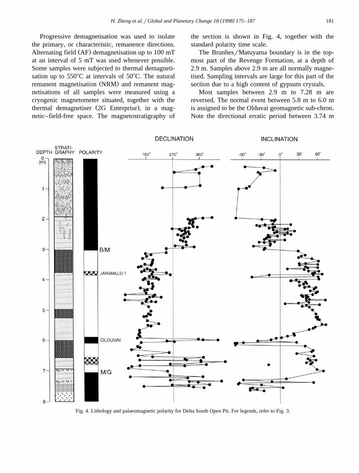
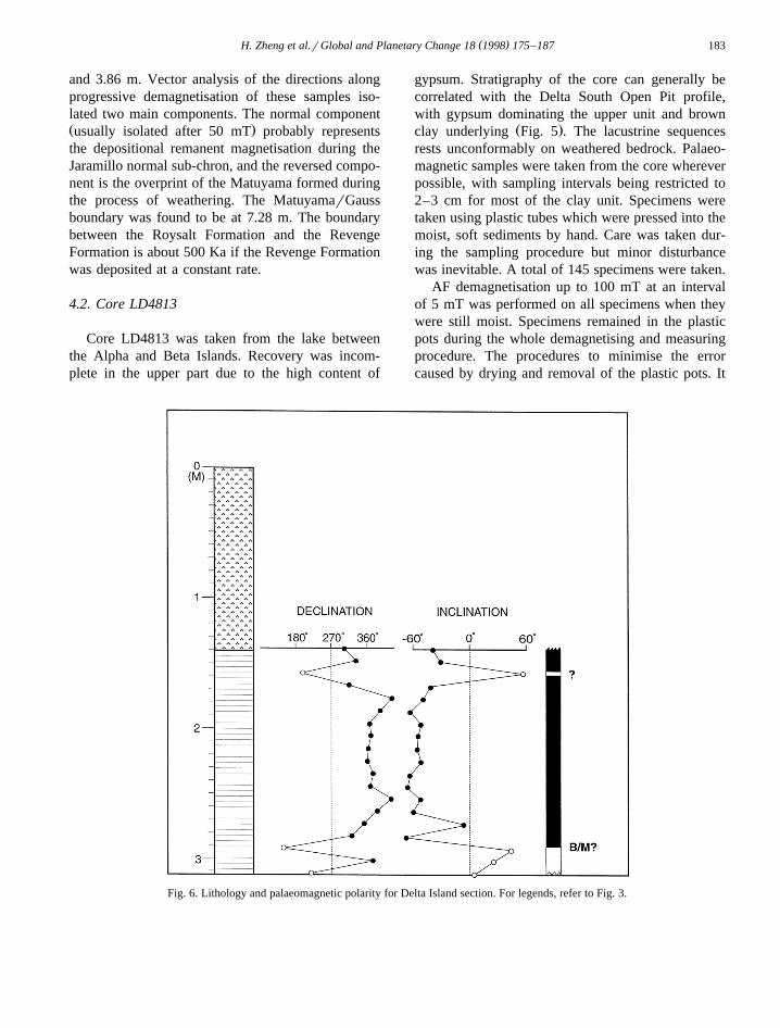
4.2. Core LD4813
Core LD4813 was taken from the lake betweenthe Alpha and Beta Islands. Recovery was incom-plete in the upper part due to the high content of
gypsum. Stratigraphy of the core can generally becorrelated with the Delta South Open Pit profile,with gypsum dominating the upper unit and brown
Ž .clay underlying Fig. 5 . The lacustrine sequencesrests unconformably on weathered bedrock. Palaeo-magnetic samples were taken from the core whereverpossible, with sampling intervals being restricted to2–3 cm for most of the clay unit. Specimens weretaken using plastic tubes which were pressed into themoist, soft sediments by hand. Care was taken dur-ing the sampling procedure but minor disturbancewas inevitable. A total of 145 specimens were taken.
AF demagnetisation up to 100 mT at an intervalof 5 mT was performed on all specimens when theywere still moist. Specimens remained in the plasticpots during the whole demagnetising and measuringprocedure. The procedures to minimise the errorcaused by drying and removal of the plastic pots. It
Fig. 6. Lithology and palaeomagnetic polarity for Delta Island section. For legends, refer to Fig. 3.
( )H. Zheng et al.rGlobal and Planetary Change 18 1998 175–187184
is also partly for this reason that only AF demagneti-sation was used.
The inclinations of the specimens, together withthe interpreted magnetostratigraphy of the core, areplotted in Fig. 5. The prominent feature of themagnetostratigraphy is that samples above 5.3 m andbelow 8.5 m are mostly normally magnetised. Thesection in between possesses both normal and re-versed magnetisations. By comparing this magne-tostratigraphy with that of the Delta South Open Pitsection, we conclude that the mixed magnetozonebetween 5.3 and 8.5 m can be assigned to be theMatuyama Reversed Chron, although it is hard toconfirm which subchron the normal specimens be-long to. It is for this reason that only the BrM andMrG boundaries are given in Fig. 5.
Another feature is the overall shallowing of theinclinations for most reversed samples. Li has stu-died the diamond drill core samples of the Mt Eclipse
Sandstone and suggested that the samples carried aŽpredominant drilling-induced remanence Li et al.,
.1991 . If so the drilling-induced magnetisation couldcause the shallowing of inclinations for the reversedsamples.
4.3. Delta Island section
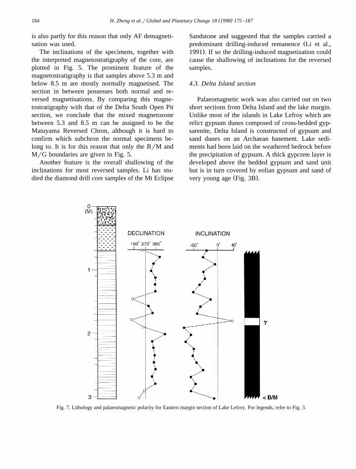
Palaeomagnetic work was also carried out on twoshort sections from Delta Island and the lake margin.Unlike most of the islands in Lake Lefroy which arerelict gypsum dunes composed of cross-bedded gyp-sarenite, Delta Island is constructed of gypsum andsand dunes on an Archaean basement. Lake sedi-ments had been laid on the weathered bedrock beforethe precipitation of gypsum. A thick gypcrete layer isdeveloped above the bedded gypsum and sand unitbut is in turn covered by eolian gypsum and sand of
Ž .very young age Fig. 3B .
Fig. 7. Lithology and palaeomagnetic polarity for Eastern margin section of Lake Lefroy. For legends, refer to Fig. 3.
( )H. Zheng et al.rGlobal and Planetary Change 18 1998 175–187 185
The lower part of the section was studied palaeo-magnetically. A reversed sample was found near thecontact of the clayrbedded gypsum units, the natureof which is unknown. All samples are normallymagnetised, except for the three near the bottom of
Ž .the section Fig. 6 . The three reversed samples wereprovisionally attributed to the Matuyama ReversedPolarity Chron, given that the Delta Island Sectionstratigraphically resembles the two sections dis-cussed above. However, three samples are not enoughto define a geomagnetic chron. The palaeomagneticstudy on Delta Island Section also dated the contactbetween the gypsumrclay units to be younger thanthe BrM boundary.
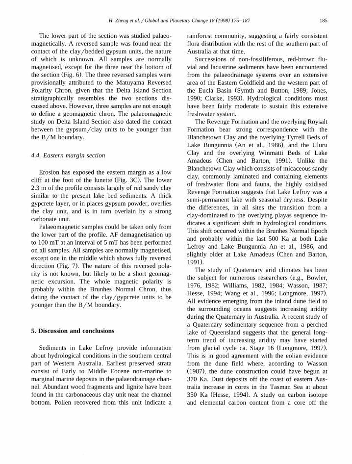
4.4. Eastern margin section
Erosion has exposed the eastern margin as a lowŽ .cliff at the foot of the lunette Fig. 3C . The lower
2.3 m of the profile consists largely of red sandy claysimilar to the present lake bed sediments. A thickgypcrete layer, or in places gypsum powder, overliesthe clay unit, and is in turn overlain by a strongcarbonate unit.
Palaeomagnetic samples could be taken only fromthe lower part of the profile. AF demagnetisation upto 100 mT at an interval of 5 mT has been performedon all samples. All samples are normally magnetised,except one in the middle which shows fully reversed
Ž .direction Fig. 7 . The nature of this reversed pola-rity is not known, but likely to be a short geomag-netic excursion. The whole magnetic polarity isprobably within the Brunhes Normal Chron, thusdating the contact of the clayrgypcrete units to beyounger than the BrM boundary.
5. Discussion and conclusions
Sediments in Lake Lefroy provide informationabout hydrological conditions in the southern centralpart of Western Australia. Earliest preserved strataconsist of Early to Middle Eocene non-marine tomarginal marine deposits in the palaeodrainage chan-nel. Abundant wood fragments and lignite have beenfound in the carbonaceous clay unit near the channelbottom. Pollen recovered from this unit indicate a
rainforest community, suggesting a fairly consistentflora distribution with the rest of the southern part ofAustralia at that time.
Successions of non-fossiliferous, red-brown flu-vial and lacustrine sediments have been encounteredfrom the palaeodrainage systems over an extensivearea of the Eastern Goldfield and the western part of
Žthe Eucla Basin Symth and Button, 1989; Jones,.1990; Clarke, 1993 . Hydrological conditions must
have been fairly moderate to sustain this extensivefreshwater system.
The Revenge Formation and the overlying RoysaltFormation bear strong correspondence with theBlanchetown Clay and the overlying Tyrrell Beds of
Ž .Lake Bungunnia An et al., 1986 , and the UluruClay and the overlying Winmatti Beds of Lake
Ž .Amadeus Chen and Barton, 1991 . Unlike theBlanchetown Clay which consists of micaceous sandyclay, commonly laminated and containing elementsof freshwater flora and fauna, the highly oxidisedRevenge Formation suggests that Lake Lefroy was asemi-permanent lake with seasonal dryness. Despitethe differences, in all sites the transition from aclay-dominated to the overlying playas sequence in-dicates a significant shift in hydrological conditions.This shift occurred within the Brunhes Normal Epochand probably within the last 500 Ka at both LakeLefroy and Lake Bungunnia An et al., 1986, and
Žslightly older at Lake Amadeus Chen and Barton,.1991 .
The study of Quaternary arid climates has beenŽthe subject for numerous researchers e.g., Bowler,
1976, 1982; Williams, 1982, 1984; Wasson, 1987;.Hesse, 1994; Wang et al., 1996; Longmore, 1997 .
All evidence emerging from the inland dune field tothe surrounding oceans suggests increasing aridityduring the Quaternary in Australia. A recent study ofa Quaternary sedimentary sequence from a perchedlake of Queensland suggests that the general long-term trend of increasing aridity may have started
Ž .from glacial cycle ca. Stage 16 Longmore, 1997 .This is in good agreement with the eolian evidencefrom the dune field where, according to WassonŽ .1987 , the dune construction could have begun at370 Ka. Dust deposits off the coast of eastern Aus-tralia increase in cores in the Tasman Sea at about
Ž .350 Ka Hesse, 1994 . A study on carbon isotopeand elemental carbon content from a core off the
( )H. Zheng et al.rGlobal and Planetary Change 18 1998 175–187186
northwest Australia also suggests an increasing arid-ity in the Australian continent over the last 300 Ka.
In exploring the causes of aridity in Australia,Ž .Williams 1984 listed five factors which are respon-
sible for the development of arid conditions in theAustralian continent. The northward drift of Aus-tralian continent to its present latitudinal position is,by far, the most important. The break up of theGondwanaland of which Australia was once a part,triggered the Cenozoic cooling of the southern ocean,leading to the build-up of the Antarctic ice sheet andprobably the onset of the Northern Hemisphereglaciations. Orbital forcing became more prominentin driving the glacial interglacial cycles during theQuaternary, as recorded in the Chinese loess depositsŽ . Že.g., Kukla, 1987 and deep-sea sediments e.g.,
.Imbrie et al., 1984 . The Australian Quaternary cli-mates may have well followed the global glacial–in-terglacial variations in a form of different magnitudeof glacial ‘dryness’. The trend of increasing aridityin Australia shows correspondence with general in-crease of dust deposition in the Chinese Loess Plateau
Ž .over the last 530 Ka Rea, 1994 , after the climaticperiodicity shifted from 400 Ka dominance to 100
Ž .Ka dominance Liu et al., 1993 around about 900-600 Ka. This also corresponds with the occurrence oflargest glaciations at Scandinavia and Barents SeaŽ .Mangerud et al., 1996 during the last 900 Ka whenthe 100 Ka astronomic cycle became important. Theonset of full aridity in Australia may well indicatethat the impact of global glacial–interglacial cycleson Australian climate, especially the large scale ‘dry-ness’, resulted from the 100 Ka variations reached
Ž .beyond its threshold Williams, 1994 .
Acknowledgements
This is part of a cooperative project between TheUniversity of Western Australian and Western Min-
Ž .ing WMC and funded by a postgraduate researchscholarship of The University of Western Australia.Help from Dr. Bob Watchorn, Dr. Kim Hein, andMr. Colin Woolward of WMC is gratefully acknowl-edged. Prof. John Dodson and Jijun Lu assisted withthe pollen analysis. Prof. Jim Bowler and Dr. Mau-reen Longmore critically reviewed the manuscript.Dr. John Glover kindly improved the English of the
manuscript. Permission to publish was granted byWMC through B. Watchron. Tectonic Special Re-search Centre Publication No. 8.
References
An, Z.S., Bowler, J.M., Opdyke, N.D., Macumber, P.G., Firman,J.B., 1986. Palaeomagnetic stratigraphy of Lake Bungunnia:Plio- Pleistocene precursor of aridity in the Murray Basin,southeastern Australia. Palaeogeography, Palaeoclimatology,Palaeoecology 54, 219–239.
Bint, A.N., 1981. An Early Pliocene pollen assemblage from LakeTay, south-western Australia, and its phytogeographic implica-tions. Aust. J. Bot. 29, 277–291.
Bowler, J.M., 1976. Aridity in Australia: age, origins and expres-sion in aeolian landforms and sediments. Earth Sci. Rev. 12,279–310.
Bowler, J., 1982. Aridity in the late Tertiary and Quaternary ofŽ .Australia. In: Barker, W.R., Greenslade, P.J.M. Eds. , Evolu-
tion of the Flora and Fauna of arid Australia. Peacock Publica-tions, pp. 35–45.
Bowler, J.M., 1983. Lunettes as indices of hydrologic change: areview of Australian evidence. Proc. R. Soc. Victoria 95,147–168.
Chen, X.Y., Barton, C.E., 1991. Onset of aridity and dune-build-ing in central Australia: sedimentological and magnetostrati-graphic evidence from Lake Amadeus. Palaeogeography,Palaeoclimatology, Palaeoecology 84, 55–73.
Clarke, J.D.A., 1993. Stratigraphy of the Lefroy and Cowanpalaeodrainages, Western Australia. J. R. Soc. Western Aust.76, 13–23.
Clarke, J.D.A., 1994. Geomorphology of the Kambalda region,Western Australia. Aust. J. Earth Sci. 41, 229–239.
Cockbain, A.E., 1968. The stratigraphy of the Plantagenet Group,Western Australia. Geol. Survey Western Aust. Ann. Rep.1967, 99–101.
Hesse, P.P., 1994. The record of continental dust from Australiain Tasman Sea sediments. Q. Sci. Rev. 13, 257–272.
Imbrie, J., Hays, J.D., Martinson, D.G., McIntyre, A., Mix, A.C.,Morley, J.J., Pisias, N.G., Prell, W.L., Shackleton, N.J., 1984.The orbital theory of Pleistocene climate: support from arevised chronology of the marine d 18 O record. In: Berger, A.,
Ž .Imbrie, J., Hays, J., Kukla, G., Saltzman, B. Eds. , Mi-lankovitch and Climate, Part 1. Plenum Reidel, Dordrecht, pp.269–305.
Jones, B.G., 1990. Cretaceous and Tertiary sedimentation on thewestern margin of the Eucla Basin. Aust. J. Earth Sci. 37,317–329.
Kemp, E.M., 1978. Tertiary climatic evolution and vegetationhistory in the southeast Indian Ocean region. Palaeogeogra-phy, Palaeoclimatology, Palaeoecology 24, 169–208.
Kukla, G., 1987. Loess stratigraphy in central China. Q. Sci. Rev.6, 191–219.
Li, Z.X., Powell, C., McA and Morris, D.G., 1991. Syn-deforma-tional and drilling-induced remanent magnetisation from dia-
( )H. Zheng et al.rGlobal and Planetary Change 18 1998 175–187 187
mond drill cores of the Mt. Eclipse Sandstone, central Aus-tralia. Aust. J. Earth Sci. 38, 473–484.
Liu, T.S., Ding, Z.L., Yu, Z.W., Rutter, N., 1993. Susceptibilitytime series of the Baoji section and the bearings on palaeocli-matic periodicities in the last 2.5 Ma. Q. Int. 17, 33–38.
Longmore, M.E., 1997. Aridity in Australia: Pleistocene recordsof palaeohydrological and palaeoecological change from theperched lake sediments of Fraser Island, Queensland, Aus-
Ž .tralia. Q. Int. in press .Mangerud, J., Jansen, E., Landvik, J.Y., 1996. Late Cenozoic
history of the Scandinavian and Barents Sea ice sheets. GlobalPlanet. Change 12, 11–26.
Parker, F., 1988. Palynology of samples from Lake Lefroy. Kam-Ž .balda Nickel Operations Western Mining Geology Depart-
ment Technical Report 2922.Rea, D., 1994. The palaeoclimatic record provided by aeolian
deposition in the deep sea: the geologic history of wind. Rev.Geophys. 32, 159–195.
Symth, P.R., Button, A., 1989. Gold exploration in the Tertiarypalaeodrainage systems of Western Australia. In: Bhappu,
Ž .R.B., Harton, R.J. Eds. , World Gold ’89. Gold Forum onTechnology and Practices. Proceedings of the First Joint Inter-national Meetings Between the Society of Mining Engineersand the Australasian Institute of Mining and Metallurgy. Reno,NV. pp. 262–269.
Van de Graaff, W.J.E., Crowe, R.J., Bunting, J.A., Jackson, M.J.,1977. Relict of early Cenozoic drainage in arid WesternAustralia. Z. Geomorphol. 21, 379–400.
Wang, X., Bird, M., van der Karrs, S., Kershaw, P., Bishop, P.,1996. Reconstruction of the last 300 Ka fire history of theAustralian continent from a deep sea core off NW Australia.In: Geol. Soc. Aust., Abstracts No. 41, 13th Australian Geo-logical Convention, Canberra. p. 459.
Warren, J.K., 1982. The hydrological settings, occurrence andsignificance of gypsum in late Quaternary salt lakes in SouthAustralia. Sedimentology 29, 609–637.
Wasson, R.J., 1987. Desert dune building, dust raising and palaeo-climate in the Southern Hemisphere during the last 280,000
Ž .years. In: Donnelly, T.H., Wasson, R.J. Eds. , CLIMANZ 3:Proceedings of the 3rd Symposium on the Late QuaternaryClimatic History of Australia. pp. 123–137.
Williams, D.L.G., 1982. Multiple episodes of Pleistocene dune-building at the end of the Head of Spencer Gulf, SouthAustralia. Search 13, 88–90.
Williams, M.A.J., 1984. Cenozoic evolution of arid Australia. In:Ž .Cogger, H.G., Cameron, E.E. Eds. , Arid Australia. Aus-
tralian Museum, Sydney, pp. 59–78.Williams, M.A.J., 1994. Cenozoic climatic changes in deserts: a