DEPARTMENT OF PLANNING & ECONOMIC DEVELOPMENT Nicolle Goodman, Director CITY OF SAINT PAUL 25 West Fourth Street, Ste. 1400 Telephone: 651-266-6700 Melvin Carter, Mayor Saint Paul, MN 55102 Facsimile: 651-266-6549 MEMORANDUM TO: Heritage Preservation Commissioners FROM: George Gause, Heritage Preservation Supervisor RE: November 30, 2020 HPC meeting – System for Survey Two main documents of the Heritage Preservation Commission (HPC) discuss survey as a major component of the duties given to the HPC: Legislative Code Sec. 73.04. - Powers and duties of the commission. (2) Survey. The commission shall conduct a continuing survey of all areas, places, buildings, structures or similar objects in the city which the commission, on the basis of information available or presented to it, has reason to believe are or will be eligible for designation as heritage preservation sites. Certified Local Government Agreement 1. As a Certified Local Government (CLG) established under the provisions of “Guidelines of Implementation of Certified Local Government Programs in Minnesota” and 36 CFR 61.5 and 61.7, made a part of this agreement by reference, the City of St. Paul agrees to: c. Maintain a system for survey and inventory of historic properties. The attached draft System for Survey is a basic framework of initiating and planning surveys to identify historic resources in the City of Saint Paul. It is intended that this will be the plan until 2030 as long as an annual budget allotment is received from the City. The HPC Survey & Designation committee discussed the draft on November 2, 2020. We will discuss this document and the recommendations at the November 30 HPC meeting. This document is a draft. Input, comments and suggestions are welcome. - End -
Transcript
DEPARTMENT OF PLANNING & ECONOMIC DEVELOPMENT Nicolle Goodman, Director
CITY OF SAINT PAUL 25 West Fourth Street, Ste. 1400 Telephone: 651-266-6700 Melvin Carter, Mayor Saint Paul, MN 55102 Facsimile: 651-266-6549
MEMORANDUM TO: Heritage Preservation Commissioners FROM: George Gause, Heritage Preservation Supervisor RE: November 30, 2020 HPC meeting – System for Survey
Two main documents of the Heritage Preservation Commission (HPC) discuss survey as a major component of the duties given to the HPC: Legislative Code Sec. 73.04. - Powers and duties of the commission.
(2) Survey. The commission shall conduct a continuing survey of all areas, places, buildings, structures or similar objects in the city which the commission, on the basis of information available or presented to it, has reason to believe are or will be eligible for designation as heritage preservation sites.
Certified Local Government Agreement
1. As a Certified Local Government (CLG) established under the provisions of “Guidelines of Implementation of Certified Local Government Programs in Minnesota” and 36 CFR 61.5 and 61.7, made a part of this agreement by reference, the City of St. Paul agrees to:
c. Maintain a system for survey and inventory of historic properties. The attached draft System for Survey is a basic framework of initiating and planning surveys to identify historic resources in the City of Saint Paul. It is intended that this will be the plan until 2030 as long as an annual budget allotment is received from the City. The HPC Survey & Designation committee discussed the draft on November 2, 2020. We will discuss this document and the recommendations at the November 30 HPC meeting. This document is a draft. Input, comments and suggestions are welcome.
- End -
System for Survey: City of Saint Paul 2021-2030 November 12, 2020 *Draft
A survey can provide information about the context and history of Saint Paul. This System of Survey is a basic framework of initiating and planning historic context studies, reconnaissance or intensive surveys to identify, evaluate, map and document historic properties or resources in the City of Saint Paul.
Survey Types There are two varieties of survey; Historic Context Surveys and Historic Surveys. Historic context surveys look at larger areas and can be focused on an overarching resource such as fire stations or parks. Historic surveys study individual structures in varying extents to determine integrity and eligibility.
Context Survey A historic context survey seeks to identify the overarching historic resources of an area. The Secretary of the Interior's Standards for Archeology and Historic Preservation defines a historic context as: an organizational framework that groups information about related historic properties based on a theme, geographical area, and period of time.1 Its primary purpose is to provide the necessary historical framework for identifying and evaluating resources. Context surveys can be developed around any subject; however, they are often narrowed by year of study, resource type, or geographic area. Historic contexts can also be developed at a variety of scales appropriate for Reconnaissance (Phase I) or Intensive (Phase II) surveys as well as for local, state, and regional planning efforts. The estimate cost of a context study ranges from $25,000-$70,000.
Additional information on writing historic contexts can be found in the 2009 National Park Service (NPS) document “The Components of a Historic Context”. Applicable NPS guidelines should be used to guide content and format of historic context surveys. Any context survey document is expected to include, at a minimum:
1. Summary of what the context encompasses; 2. General historical background of the subject(s); 3. Explanation of the context’s parameters (methodology of study); 4. Information relevant to the development of the context’s theme(s) or area(s) of significance; 5. Identification of the property types associated with the context; 6. Relevance using each of the National Register Criteria; and 7. Bibliography.
Historic Resource Surveys The NPS defines a survey as “a process of identifying and gathering data on a community’s historic resources. It includes field survey—the physical search for and recording of historic resources on the ground—but it also includes planning and background research before field survey begins, organization and presentation of survey data as the survey proceeds, and the development of inventories.” Surveys
1 Bulletin 24, 6.
Saint Paul System for Survey
November 12, 2020* Draft
2
are used for identification of historic resources and future planning. If a previous survey was conducted more than ten (10) years from the current date typically a resurvey of the area is necessary.
All historic and architectural surveys must be conducted under the direction of a professional with education and experience that meet the Secretary of the Interior’s Professional Qualification Standards. It may be necessary to seek multiple professionals to ensure a thorough understanding of the applicable historic contexts. Volunteers and those without professional training may work with or under the direction of a Principal Investigator who meets the qualifications.
Phases of Historic Surveys Surveys are completed at one of two levels: Reconnaissance/windshield (Phase I) or Intensive (Phase II).
Reconnaissance Survey (Phase I) Reconnaissance surveys are typically reserved for areas where no survey had occurred in the past. Reconnaissance surveys are used to identify areas of concentration that can be the focus of an intensive survey.
The intent of a reconnaissance survey, sometimes called a windshield survey, is to collect data on an area that has not been previously surveyed. Generally, this is the primary work used to gain an understanding of the character and resources in an area for possible intensive survey or study of individual sites and thematic areas. The survey is intended to make recommendations for additional intensive survey work. Reconnaissance surveys don’t determine eligibility.
Intensive Survey (Phase II) Intensive surveys document all buildings, structures, sites, and objects in detail to evaluate the potential as a historic resource. In addition to a field survey to review the physical attributes of a property, research is also performed to understand the historic and cultural significance of a property. Intensive surveys determine eligibility.
Considerations with Surveys
Boundaries A survey requires clearly established geographic limits of the study area. The rationale behind the boundaries must be explained in the methodology section of the report. Boundaries for reconnaissance surveys do not need to be justified by historical association or research. However, Intensive survey boundaries are justified by research, integrity and context.
Significance2 Significance is the association of a property with different aspects such as architecture, archeology, engineering, cultures, people, or events. A property must possess significance to be considered a historic resource. How the property relates to the context of the area is an important consideration.
Integrity3 Integrity addresses how a property conveys significance. There are a set series of aspects to consider: location, design, setting, materials, workmanship, feeling, and association.
Community support The level of community support for designation is helpful when evaluating areas for survey. It may become apparent that the community is fully behind designation or that there is a need to provide further education about what survey and designation are prior to commencing a survey.
Cost The estimated cost for a reconnaissance survey is $150-$200 per parcel. The estimated cost of intensive survey is $200-$250 per parcel. Complex properties or sites may cost more.
These cost include: Fieldwork in the survey area (photographs, completing inventory forms, etc.) Primary and secondary research4 (records, census, directories, newspapers, literature,5 etc.) Maps (survey area, historic, photo key, etc.) Updating existing city contexts Participation in neighborhood meetings Project update meetings with City staff Completion of an illustrated survey report detailing the research, findings and recommendations
How is Survey Information Used? Historic resource surveys are a essential planning and development tool. The information learned is used to understand, identify, evaluate, and protect potential historic and cultural resources.
Section 1066 review requires federal agencies to consider the effect of their activities on potential historic properties. Survey information is a component of conducting environmental reviews to identify potential adverse effects, and avoiding, minimizing, or mitigating adverse effects.
Historic surveys compile information about communities, people, and properties. The information gathered provides details about the historic character of an area and can be incorporated in community plans to assist in making informed decisions for use of potential historic and cultural resources.
4 U.S. Department of the Interior, National Park Service, National Register Bulletin 24: Guidelines for Local Surveys: A Basis for Preservation Planning (1977, rev. 1985), Accessed 31 August 2020, https://www.nps.gov/nr/publications/bulletins/nrb24/nrb24.pdf, 29, 69-70; National Park Service, Archeology and Historic Preservation: Secretary of Interior’s Standards for Identification, Secretary of the Interior’s Guidelines for Identification, Accessed 31 August 2020, https://www.nps.gov/history/local-law/arch_stnds_2.htm. 5 https://mn.gov/admin/assets/surveymanual_tcm36-327675.pdf pg. 5 6 https://www.achp.gov/protecting-historic-properties/section-106-process/introduction-section-106
A survey has a role with emergency disaster response where it is critical to have knowledge about the potential historic resources in the community. For more information about disaster planning in Minnesota, see Thinking About the Unthinkable: A Disaster Plan for Historic Properties in Minnesota.7
Surveys provide information that contribute to research and education. Survey information can be used to teach about architecture, provide information about the history of a property and/or community, and to help us understand our role as stewards of our environments and communities. Survey reports and associated materials are available to the public.
Tools that Utilize Surveys
Neighborhood Plans A Neighborhood Plan is a community-led framework for guiding the future development and growth of an identified area. An essential component is the community involvement in the process by taking the lead in producing the plan for the area. Neighborhood plans should identify character which is important to residents and can include specific objectives and strategies to protect neighborhood character. Architectural Design Standards Another mechanism is to established a set of standards required to maintain specific characteristics for an area. The standards would be established into the City of Saint Paul Zoning Code and administered by the Department of Safety and Inspections (DSI). Standards would need to be created. Demolition Delay Demolition delay establishes a hold on the issuance of a city demolition permit for structures that meet specific established criteria. The delay is a period during which other options can be explored. A demolition delay ordinance would need to be created in Saint Paul to utilize this option. Façade Easements Property owners of historic buildings designated at the national, state or local level could elect to donate a façade easement to a participating non-profit agency. Preservation easements protect the exterior facades of a building. An easement "runs with the land" – meaning it is perpetual and remains in place when the property is sold. This is the only tool, beside local designation, that has the potential to halt demolition. Designation A possible outcome of a survey is designation that recognizes the importance of a building or district’s historical, architectural, cultural or geographical value in a community. There are three types of designation (national, state and local) that can be applied to an individual building or to a collection of buildings. The designation types have differing criteria and degrees of regulation, though a property can potentially be designated as all three types. Local designation could protect from demolition and historically insensitive alterations that can damage neighborhood and architectural character.
Legislative Hearings Properties that are classified by City Inspectors as a Category 3 vacant building go before the Legislative Officer for a public hearing and receive a recommendation that is then forwarded to the City Council for action. A survey can keep potential historic resources from being demolished.
Issues That May Affect Potential Historic Resources Natural Disaster Knowledge of potential historic resources can assist in planning a response to a natural disaster. Information about the building’s construction, materials and other details can help first responders and protect potential historic resources which may have sustained damage. Perceived threat to area It’s important to understand the concerns of a community. Threats could be direct or indirect and may begin as minor impacts which accumulate over a period and lead to major impacts. Using previous survey and context information along with permit records and planning information, direct and indirect impact patterns in the area could be identified. Patterns of demolition Occasionally, areas may experience an increase in new construction which could negatively affect potential historic resources. Patterns can be traced through permit records and a survey should be considered for these areas. Emergency Requests Occasionally staff receive requests from the public to survey a particular area due to a circumstance that is occurring. When reviewing emergency requests to conduct surveys in Saint Paul, staff will apply the following criteria to identify and address survey priorities:
If the area has been surveyed previously Level of threat (Immediate, Possible or No known threat) Potential for historic and/or cultural significance Community support for the survey and identification of historic resources
Emergency requests are handled on a case-by-case basis according to these criteria. City staff can assist with these requests.
Community-Led Survey
As a City agency, Heritage Preservation has a set plan for future context, reconnaissance or intensive surveys. Communities may desire a different timeframe for completion of a survey. Communities can organize to accomplish a community-led surveys to address their needs. Community-led means that members of the community would be responsible for funding a consultant, assisting with aspects of research and creating final recommendations. Community-led survey can play an important and complementary role in recording historic resources for planning and preservation.
Saint Paul System for Survey
November 12, 2020* Draft
6
There are several key points that need to be considered when sponsoring a survey: Consultants
Professional consultants must be retained to accomplish the survey and oversee any volunteers. Consultant duties and expectations should be described in an RFP and ultimately a survey contract. Consultants must be professionals with the education and experience that meets the Secretary of the Interior’s Professional Qualification Standards. It may be necessary to seek multiple professionals to ensure a thorough survey or to execute various parts of the work.
Research
The community can assist with archival research, verbal research and survey fieldwork. The requirements for research can differ depending on project expectations or survey types. Research is necessary for adequate documentation and analysis. The Minnesota Historic and Architectural Survey Manual8 can provide further direction.
Boundaries The community, along with their consultants and City staff, should clearly establish the geographic limits of the study area. The rationale behind the survey boundary must be clearly articulated in the methodology section of the final report.9 Boundaries may need to be justified by historical association.
Survey Report The results of surveys need to be synthesized in a report that compiles the data. The depth of information will vary according to the level of survey. Reports will include various information such as (but not limited to) a description of the project, results, boundary map, list of inventoried properties and any historic ephemera like photos, drawings or maps.
Funding
Minnesota Historical and Cultural Heritage (‘Legacy’) Grants:
• Large Grant (annual): Over $10,000, projects must be completed within 6-18 months. The application process can take approximately 5 months (requires a preapplication). Matching funds are needed when submitting final application.
• Small Grant (quarterly): Less than $10,000, projects must be completed in 12 months. Matching funds are needed when submitting final application. For more information: https://www.mnhs.org/preservation/legacy-grants
City Staff
City of Saint Paul staff are available to provide advice and review draft documents. City staff should be part of periodic check-ins with the consultant and community. The city requests a copy of the final document for the record.
8 Minnesota Historical Society Historic and Architectural Survey Manual. Heritage Preservation Department, Revised 6/2017. https://mn.gov/admin/assets/surveymanual_tcm36-327675.pdf 9 https://www.nps.gov/subjects/nationalregister/upload/Boundaries-Completed.pdf Accessed
Equity City staff evaluate how a survey could affect a neighborhood. Consideration and discussion of the social, economic, historical, cultural and environmental impacts can be considered.
When reviewing proposed survey projects, staff will evaluate to make sure Saint Paul’s equity goals are addressed. Specifically; ’How we grow, develop and invest over the next 20 years must be done in a way that reduces racial and social disparities in jobs, income, housing cost burden, education and homeownership.’- Saint Paul Comprehensive Plan
Policy Recommendations
Ideally, survey in the city of Saint Paul should be an ongoing annual workplan item, accomplishing one per year. The recommended plan for survey is to focus on needed historic context surveys, facilitate reconnaissance surveys of areas where little is known and promote intensive surveys of areas identified as potential districts. This document makes recommendations that would inform our workplan until 2030. After 2030, the recommendations should be reevaluated.
Policy for HRA properties
Any Housing and Redevelopment Authority (HRA) properties should be researched to determine potential historic resources status. Identification of sites/districts that are potential historic resources will help in future planning efforts. PED-HP staff shall maintain a list of HRA properties that includes known heritage preservation information.
Policy for City projects
Identifying historic resources in and surrounding a project area aids decision makers in understanding the history and contexts of a site, developing plans and identifying impacts that may need to be avoided, altered, and/or mitigated. Early planning stages for large projects should include survey of the site(s) and surrounding area.
City Budget
An annual budget is needed for staff to accomplish ongoing survey. It is recommended that an annual amount of $55,000 to $75,000 be allocated depending on the survey type and size.
Saint Paul System for Survey
November 12, 2020* Draft
8
Survey Priority Recommendations
Surveys require time and funding. This list has been developed with the understanding that due to limited staff (and other duties) only one survey is possible annually. The recommendations have been divided into multiple types to represent various concentrations of potential survey. If a situation arises that has not been anticipated, staff will utilize the critical decision-making criteria to evaluate if a survey not on the list should/could receive priority. The list is focused to avoid overwhelming lists of possibilities. These recommendations represent work plan/budget items for the next ten years. This is not a comprehensive list, just the top items to be considered.
In 1983 over 100 volunteers and student interns assisted in a survey of Ramsey County. Although long out-of-date, the records of this effort give us information on area historic resources. Since 1983, approximately 17% of the city has been resurveyed.
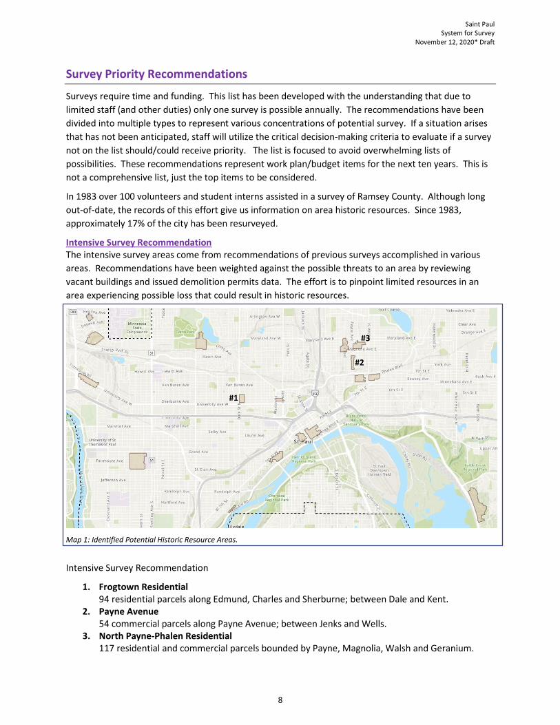
Intensive Survey Recommendation The intensive survey areas come from recommendations of previous surveys accomplished in various areas. Recommendations have been weighted against the possible threats to an area by reviewing vacant buildings and issued demolition permits data. The effort is to pinpoint limited resources in an area experiencing possible loss that could result in historic resources.
1. Frogtown Residential 94 residential parcels along Edmund, Charles and Sherburne; between Dale and Kent.
2. Payne Avenue 54 commercial parcels along Payne Avenue; between Jenks and Wells.
3. North Payne-Phalen Residential 117 residential and commercial parcels bounded by Payne, Magnolia, Walsh and Geranium.
#1
#2
#3
Saint Paul System for Survey
November 12, 2020* Draft
9
Reconnaissance Survey Recommendation
Reconnaissance survey has two focus areas; 1) areas where some research and information that have been accomplished previously (but no survey) and 2) areas where next to nothing is known.
The focus areas’ boundaries represent a concentration of pre-1929 structures where potential historic resources would likely be found. Recommendations have been weighted against the possible threats to an area by reviewing vacant buildings and issued demolition permits. The effort is to pinpoint limited resources in an area experiencing possible loss that could result in historic resources.
Map 2: Concentrated Areas of Pre-1929 Structures which little is known.
Reconnaissance Recommendation: Little Known Areas These are areas that were built before 1929, but little is known about potential historic resources. Preliminary investigations may alter the boundary to be studied.
1. D2-White Bear & Minnehaha 2. D6-Marion & Cottage 3. D10-Ryde & Hatch (Naming: District Council & cross streets)
#1
#2
#3
Saint Paul System for Survey
November 12, 2020* Draft
10
Map 3: Concentrated Areas of Pre-1929 Structures which historic resource information is available.
Reconnaissance Recommendation: Known Areas These are areas that the 1983 survey and other projects have identified multiple historic resources. Formal survey is needed due to development and demolition that is active in these areas
1. D3-West Saint Paul ‘Winslow’ 2. D8-Central Saint Paul ‘Milton’ 3. D12-St. Anthony ‘Commonwealth’ (Naming: District Council & central street)
Saint Paul System for Survey
November 12, 2020* Draft
11
Context Survey
City-wide context survey is a proactive, systematic study of topic areas within a municipality in order to identify sites of value according to a defined list of criteria. An outcome of the survey will be greater clarity about the location and value of the city’s cultural heritage resources.
City-Wide Context Recommendation
1. Underrepresented People. Exploration of persons, time frames and themes of underrepresented people in Saint Paul. Beginning effort by doing literature research and compiling documentation that will lead to future context research. A request for proposals would detail this item and future survey steps that would come from information learned.
2. The Green Book Saint Paul sites. The Green Book (1936–67) was a travel guide published in the period before passage of Civil Rights Act of 1964 that identified businesses that would accept African American customers to make travel comfortable and safe. The study would compile a comprehensive list of these locations in Saint Paul and potential integrity.
3. Post-WWII Development, Mid-Century Modernism. Mid-century modern is an American design movement that was popular from 1945 to 1969. It is typically characterized by clean, simple lines.
Thematic Context Recommendation
A thematic survey would be a comprehensive collection of works and associations with a particular connection. The theme could be a person, peoples, sites or items that had a prominent role in Saint Paul’s development and history. As of late, there have been challenges resulting in loss from the following three architects.
Clarence Wesley "Cap" Wigington (1883-1967) was a renowned architect. He served 34 years as senior designer for the City of Saint Paul, Minnesota's architectural office when the city had an ambitious building program. While sixty of his buildings still stand in St. Paul, only four are recognized on the National Register of Historic Places.
Cass Gilbert (1859-1934) was a prominent American architect; he served as president of the American Institute of Architects in 1908–09. Gilbert started a practice in St. Paul with James Knox Taylor from 1882 until 1898. Many of his area buildings are still standing, including more than a dozen private residences on Summit Avenue.
Charles Albert Hausler (1889-1971) was an American architect. Over his long career he had a major impact on the built environment of Saint Paul, Minnesota. As the first person to hold the office of city architect, he designed many public buildings, including Saint Paul's three Carnegie libraries. He also designed churches, commercial buildings, and homes.


![St. Paul daily globe (Saint Paul, Minn.) 1888-09-05 [p 2] · 2017. 12. 15. · 2 THE SAINT PAUL DAILY GLOBE: WEDNESDAY MORNING, SEPTEMBER 5, 1888. SAINT PAUL. CHIT CHAT CORNER. Editors](https://static.documents.pub/doc/80x56/60af10202e534975804f4b01/st-paul-daily-globe-saint-paul-minn-1888-09-05-p-2-2017-12-15-2-the.jpg)


![The Saint Paul globe (Saint Paul, Minn.) 1903-04-18 [p 7]](https://static.documents.pub/doc/80x56/619f25408a76c32a2b4b0754/the-saint-paul-globe-saint-paul-minn-1903-04-18-p-7.jpg)
